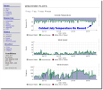
Without much experience with these guys (breitbart.com), here was their header: Greenland just broke the record for the coldest July day ever recorded in the Northern Hemisphere at -33C and a graph below:
http://www.breitbart.com/big-government/2017/07/07/delingpole-record-breaking-cold-in-greenland-alarmists-look-an-arctic-squirrel/
From the AER's Dr. Judah Cohen (Atmospheric and Environmental Research) she cites this following a summary: http://www.aer.com/science-research/climate-weather/arctic-oscillation
Will have to see where this shifts to in August.
http://www.breitbart.com/big-government/2017/07/07/delingpole-record-breaking-cold-in-greenland-alarmists-look-an-arctic-squirrel/
From the AER's Dr. Judah Cohen (Atmospheric and Environmental Research) she cites this following a summary: http://www.aer.com/science-research/climate-weather/arctic-oscillation
July 16, 2017
Dr. Judah Cohen from Atmospheric and Environmental Research (AER) recently embarked on an experimental process of regular research, review, and analysis of the Arctic Oscillation (AO). This analysis is intended to provide researchers and practitioners real-time insights on one of North America’s and Europe’s leading drivers for extreme and persistent temperature patterns.
With the start of spring I will be transitioning to a spring/summer schedule, which is once every two weeks. Snow accumulation forecasts will be replaced by precipitation accumulation forecasts. Also there will be less emphasis on ice and snow boundary conditions (which are both now in their seasonal decline) and their influence on hemispheric weather.
Summary
The Arctic Oscillation (AO) is currently positive and is predicted to trend slowly negative through the end of the week towards neutral. The forecast is for the AO to remain neutral next week, likely a sign of uncertainty.
The current positive AO is reflective of mostly negative pressure/geopotential height anomalies across the Arctic and mostly positive pressure/geopotential height anomalies across the mid-latitudes. The North Atlantic Oscillation (NAO) is also currently positive with negative pressure/geopotential height anomalies across Greenland and Iceland.
For much of the week ridging/positive geopotential height anomalies and warm temperatures will dominate Western Europe while troughing/negative geopotential height anomalies and cool temperatures will dominate Eastern Europe.
However, by the weekend and into next week the pattern is predicted to flip when troughing/negative geopotential height anomalies and cooler temperatures will dominate Western Europe while ridging/positive geopotential height anomalies and warm temperatures will dominate Eastern Europe.
The general theme for the atmospheric circulation across North America is more of the same with a general continuation of ridging/positive geopotential height anomalies centered across western North America contributing to weak/moderate troughing in eastern North America. This will likely keep the sustained heat focused in the Western United States (US) with closer to seasonable temperatures in the Eastern US.
For East Asia, the model forecast is for initially ridging/positive geopotential height anomalies and above normal temperatures giving way to more troughing/negative geopotential height anomalies over the next two weeks.
Impacts
We are in the heart of summer in the Northern Hemisphere (NH) and I continue to expect persistence to remain relatively strong. Despite positive geopotential height anomalies in the Arctic and high latitude blocking characterizing the spring, the summer has so far been mostly the opposite with negative geopotential height anomalies widespread across the Arctic and a lack of high latitude blocking or a positive AO. This favors ridging/positive geopotential height anomalies across the mid-latitudes. The ridging in the mid-latitudes has been focused across the Western US in North America and across Europe and East Asia in Eurasia. Underneath the ridging, the greatest positive departures from normal temperatures have been observed so far this summer. The most persistent troughing/negative geopotential height anomalies across the mid-latitudes have been in Western Asia. Underneath the troughing, the greatest negative departures from normal temperatures have been observed so far this summer. There has also been some weak troughing in Eastern North America with mixed and close to seasonable temperatures.
I expect little change in the average summer temperatures with above normal temperatures for Europe, East Asia, Western Canada and the Western US. The one region where temperatures will likely average below normal is Western Asia. In Southeast Canada and the Eastern US temperatures are likely to average close to normal. The models are predicting a change across Eurasia to end the month of July with more troughing/negative geopotential height anomalies and cooler temperatures for both Europe and East Asia. I do believe that there are summers when the weather pattern in June and July transitions to a different pattern in August and therefore it is possible that troughing, which has been mostly absent from Europe and East Asia so far this summer could become more common in August.
Will have to see where this shifts to in August.

