Looks like Europe will finally be experiencing more winter weather as we head into early February. What weather models are hinting at lately is a severe cold outbreak setting up this weekend into next week. A so-called Beast from the East will push extreme cold and also develop some snow towards the west and south.
The pattern over Europe and the North Atlantic has been strongly progressive over the past few weeks. In other words, this means we are seeing system after system moving from the Atlantic into the continent, delivering unsettled weather conditions regionally. But now, the general patterns are slowly coming together into a more
wintery mode.
The weather models do hint that the European continent is setting a stage for a potentially quite
significant cold outbreak, spreading into Scandinavia this week and then also towards western and central Europe early next week.
Once the cold reaches higher moisture further south, winter storms are likely to form and bring
snow for some regions. One frontal wave will cross eastern Europe on Thursday, with one system also over the UK.
Another, a potentially more significant snowstorm is forecast across central and western Europe over the weekend into early next week.
NEGATIVE NAO PHASE – GENERAL FLOW FROM THE ARCTIC
The final days of 2020 had the
new world record for surface pressure readings set in Mongolia, caused by a frigid cold air with near -55 °C over eastern Siberia (Russia). As this Arctic cold from Siberia spread towards the Pacific, it resulted in another record-setting setup for the North Pacific. A monster extratropical storm occurred, and pushed the minimum central pressure at 921 mbar, smashing the previous pressure records in the region.
But why is this important now? These large scale weather systems were so extreme and anomalous, that their dynamics sent the atmospheric waves up into the upper parts of our atmosphere, called the stratosphere. The result was a disruption of the polar vortex aloft and started a
major sudden stratospheric warming (SSW) event and lead to vortex collapse.

After the Polar Vortex collapse through early January, the weather patterns across the Northern Hemisphere are becoming very dynamic and progressive over the past few weeks. As it often happens, a strong blocking ridge develops over the polar/arctic region with a strong high-pressure system built over Greenland.
As we can see from the chart above, Greenland blocking High persists also into February, and it also extends across the whole Arctic region and the North Pole on the other side of the polar region to Alaska. This means the general flow is coming up from the northeast, across Arctic Russia towards Europe. And it brings a *lot* colder air mass towards our continent, the pure continental Polar air mass.
Actually, this is a typical negative NAO (
North Atlantic Oscillation) phase. The
negative NAO phase represents the reverse with a weaker than usual difference in pressure. Winds from the east and north-east are more frequent, bringing with them cold air, while the adjusted position of the jet stream leads to weaker and less frequent storms.

While the opposite is the
positive NAO phase (left image) which represents a stronger than usual difference in pressure between the two regions. Winds from the west dominate, bringing with them warm air, while the position of the jet stream enables stronger and more frequent storms to travel across the Atlantic. These support mild, stormy, and wet winter conditions in northern Europe.
BEAST FROM THE EAST
The term Beast from the East is a phrase used to describe cold and wintry conditions as a result of a
polar continental air mass. This happens when the surface pressure is high over Scandinavia and the Arctic region, so the flow is from the east-northeast and it delivers a polar continental air mass into western and central Europe, reaching the UK as well.
When this happens during the winter months, cold air is drawn in from the Eurasian landmass, bringing the cold and wintry conditions that give rise to the Beast from the East term. Polar continental air only reaches western and central Europe between November and April.

What does it mean for the general weather? It brings
much colder air into parts of Europe, so the morning temperatures could push below -15 to -20°C in many areas across western and central Europe.
For the UK for example, the characteristics of the air depend on the length of the sea track during its passage from Europe to the British Isles. The air is inherently very cold and dry and if it reaches southern Britain, with a short sea track over the English Channel, the weather is characterized by clear skies and severe frost.
With a longer sea track over the North Sea, the air becomes unstable and moisture is added, giving rise to showers of rain or snow, especially near the east coast of Britain. The UK’s lowest temperatures usually occur in this air mass, even lower than -10 °C at night, and sometimes remaining below freezing all day.
EXTREME COLD DEVELOPS OVER SCANDINAVIA
The patterns over Europe begin shifting into more wintery mode through mid this week, as the strong upper High over the Arctic region expands into the sub-polar regions, extending also towards Scandanavia.
Further south, three synoptic-scale systems are seen. One large depression over western Russia, over traveling across eastern Europe, and another weak low over the UK and Ireland.

As we focus on the European territory now, let’s take a closer look over the two frontal systems on Thursday. The system traveling east across eastern Europe will bring very heavy snow from northeast Germany on Wednesday night into early morning Thursday. Then the winter storm continues east quite fast across northern Poland and Belarus until Thursday evening.

There will be a sharp gradient of
heavy snow vs. heavy rain along the warm front. Portions of northern Poland and central Belarus could be blanket by around 15-20 cm of snow, even more locally. Especially heavy snow bands develop to the north of the warm front where moisture will be very high and precipitation stays as snow most of the time. But it will be wet snow, dry snow further north into the Baltic region.

The western system over the British Isles will begin Wednesday this week when the weather will stay cold in the north with sleet and snow possible across Scotland. England, Wales, and Northern Ireland will be milder with showers or longer spells of rain in the south.
Thursday and Friday become uncertain but there is a frontal system moving across northern portions of the UK and Ireland with colder air from the north moving southwards along with strengthening easterly winds.
Including some
heavy snowfall potential, precisely across Scotland. Some weather models forecast a deep snowpack for the Highlands. Attached below is the 5-day snowfall chart for western Europe, based on the ICON model. Strong east-southeast upslope flow will introduce heavy orographic snowfall into the Highlands and could potentially lead to
50-80 cm of snow until the end of the week.
Further east, some potential for a decent amount of snow is also across northern Germany into southern Denmark as snowfall could occur to the north of the warm front associated with the new frontal system on Sunday. (See more details below)

Thanks to the high pressure expected to build over Scandinavia as we head into the second half of this week, this will lead to the development of strong easterly winds across the northern portions of Europe over the weekend. The result is normally a sharp
continental cold air from Russia towards the west, spreading across southern Scandinavia, the Baltic region, Poland, and Germany towards the UK.

Thanks to the weak surface low traveling across eastern Europe, the cold pool gradually spreads into Scandinavia and the Balti region on Thursday. With temperatures quite significantly lower than normal for early February, probably 10-12 °C below.
Further south, rather a stable pattern across southern Europe and the Mediterranean region maintains unusually warm weather, with locally mild temperatures expected.
NEW WINTER STORM OVER THE WEEKEND
As the time passes into the second half of this week, the persistent upper-level high over the far northern Europe maintains a deep cold, advection from east-northeast towards western Europe.
The general steering flow then turns the Atlantic depressions further south of their typical trajectory, so storms are moving across the Bay of Biscay into France and the Alps. A large area of low surface pressure will develop accordingly.

This hints nothing else than a healthy advection of continental air mass from northern Russia, Scandinavia, and the Baltic region further west-southwest. It will be a polar continental air mass, the typical air mass for the term
Beast from the East.
We can see a large and very intense pool of
frigid cold air mass over Russia, with almost 20 °C below normal environment. Part of this air mass will be gradually spreading west towards the UK, then turning south into France as well.
The temperature forecast is definitely trending towards a
deep freeze similar to the Beast from the East experienced three years ago, in 2018. A new frontal system emerges into western Europe Saturday night through Sunday morning, and the winter precipitation is forecast to increase from northern Germany to Denmark and across the North Sea into the UK.

It will be cold enough to support
snow. So the weekend might turn much colder with strong easterly winds driving in higher moisture and heavy snow showers from the North Sea into portions of eastern England and Scotland.
Snow accumulations could be quite high in places, depending on how heavy the snow bands could develop. A much colder air mass spreads over the country from Sunday into Monday and Tuesday, with a more widespread risk of lowland snow Monday night and into Tuesday morning across England and Wales.

While a much much warmer air mass will maintain and even intensify over Southeast Europe. Thanks to the deepening pressure over the western Mediterranean in response to the cooling pattern expanding from the north.
This releases southerly winds from the subtropical region towards the southeastern portions of Europe, so a rather extreme warm advection takes place into the Balkan peninsula, Turkey, and the Black Sea region over the weekend. Temperatures will locally be very high and could easily exceed 20 °C in western Turkey.
ATLANTIC ATMOSPHERIC RIVER COULD BRING LOT OF SNOW NEXT WEEK
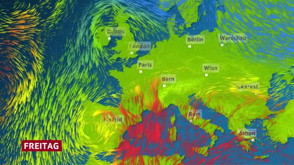
What is lately trending on the weather models regarding the pattern next week is a rather impressive setup across the European continent and the North Atlantic. The attached surface pressure chart below covers a large area, extending across the whole North Atlantic across Europe into western Europe.
We can see there is likely that the powerful upper High (hint 1055 over Greenland) will maintain across the Arctic region, while to the south, a train of winter storm systems will travel across the Atlantic from west to east.
This is an
atmospheric river, a term that describes the delivery of high moisture from the Atlantic into southern portions of Europe, so a typical negative NAO phase as we described above.

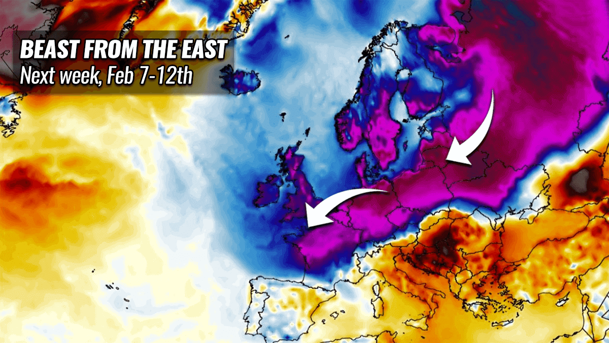
This means a lot of moisture is moving in from the west (Atlantic), but at the same time, a large cold pool of
polar continental air mass maintains across the northern portions of Europe. Pockets of this air mass keep pushing further south towards central and western Europe throughout next week.
So a deep freeze could spark Beast from the East to experience the cold air from the east to engulf the UK and Ireland after the next weekend. The turning flow to the northeast should bring some very cold air and the door to a so-called ‘
The Beast‘.
It will be a challenging forecast for the next week, as the frontal systems with snow strongly depend on the position of the upper waves. The general picture does, however, remain *very* favorable for the winter weather period to keep a large part of Europe very cold.
As long as the strong blocking high remains over the Arctic region and northern Europe, the cold advection will deliver cold to the south and west.

As we can judge from the chart for the mid-next week above, a large part of Europe could experience below normal temperatures. Especially across the northern half, but potentially also across western and central Europe. How far south and how intense the cold pool will be, is still rather uncertain, as this is about a week ahead forecast.
But the attached chart is the ensemble model forecast from the ECMWF model, so we have a general trend that is up for Europe next week. Chances are undoubtedly there that some days of deep freeze could develop, but things need to be monitored further to see how this finally evolves.
The other question besides the severe cold will be the snow potential. The interaction of the persistent atmospheric river from the Atlantic with the cold coming from the north could spark some severe
winter storms and deep snow amounts could accumulate in some regions. Attached below is the total snowfall over the next 10 days. Some areas might get into serious winter weather troubles.

Nevertheless, snow potential is quite high for many countries, thanks to the general winter weather mode developing after this weekend’s pattern flip with the arrival of the
Beast from the East continental Polar air mass.
***The images used in this article were provided by
Windy,
Wxcharts, and
NOAA.