Hello Goyacobol, I did think that flash was odd, but it happened right at the beginning of the eruption, so it might have been some volcanic detritus flung up by the original explosion, lighting up as it expanded in the less dense atmosphere. Just my thoughts on it.
You are using an out of date browser. It may not display this or other websites correctly.
You should upgrade or use an alternative browser.
You should upgrade or use an alternative browser.
Volcanoes Erupting All Over
- Thread starter Laura
- Start date
Strange. My first thought was strobes by an airplane flying across the field of view at close range from the observer, i.e between the volcano and the camera. But then notice when crossing the smoke plume there's no blink, which could mean that it is crossing behind the smoke plume. Actually, strobe lights on commercial aircraft blink at a slower pace than that seen here. Unless the video is sped up… Questions, questions.
Never thought about the video being "sped up", if so that would make the object seem to be very fast. Nothing was mentioned so maybe it was just an observation plane/helicopter. Most likely it is a time-lapsed clip. Sorry for the distraction.
it might have been some volcanic detritus flung up by the original explosion, lighting up as it expanded in the less dense atmosphere.
That is possibility too I suppose. It was the volcano explosion that is the more important event I think.
Thanks for the feedback.
I noticed what looks like a meteor streaking from the left to right about 19 seconds into the first video. It seemed kind of strange so I did some screen shots pausing for the different flashes. I spliced them together (not perfectly but just to give an idea of the path).
Does this seem a bit odd to anyone?
Strange. My first thought was strobes by an airplane flying across the field of view at close range from the observer, i.e between the volcano and the camera. But then notice when crossing the smoke plume there's no blink, which could mean that it is crossing behind the smoke plume. Actually, strobe lights on commercial aircraft blink at a slower pace than that seen here. Unless the video is sped up… Questions, questions.
Interesting, did not noticed that!, went to find if someone-channel UFO like- had something, because they had appeared in the past around-near the Popocateptel's.
Find one video that shows in slow motion, zoom and with real velocity-time, because it is indeed sped up in te above video. At minute 5:38 youtube (5:47 at the webcamsdemexico time) it appears and, it seems to "disappear" and "appear" several times following a path to the right, and the"light" seems to shrink? every time it does that
There is this other video, in which the "light" appear +- the same position, at 6:49 youtube (4:55 VolcanoYT-Cenapred) but it takes another route, it "dissapears" for an instant at 7:15 but the stars behind do not, at 7:02 there seems to be another "light"-lighter following it, until they cannot be seen 7:37.
Curiously, Popocateptl's volcano has snow. Had read reports in which people seems to be surprised but, "experts" mentioned that is common in summer because there are more rains.
Add: Sorry Music Man and goyacobol, did not see your latest post, still, I think those "lights" seem to have direction?
Last edited:
Sorry Music Man and goyacobol, did not see your latest post, still, I think those "lights" seem to have direction?
I think so too. I don't think it was any volcanic "detritus" since it traveled so far from the left and kept on moving. The normal speed video makes it look like many UFO videos with the blinking on/off or in/out. I have noticed that these sightings tend to have that in common. There is a general direction followed but there is a kind of wobble and slight increase and decrease in the speed which most planes don't do unless there might be a more windy situation. I guess I think UFO because to me it is still unknown what it really was. The smaller lights following nearby are another thing I have noticed too.

_https://www.jma.go.jp/en/volcano/forecast_02_20180915040007.html said:Azumayama Volcanic Warning (Near the crater)
13:00 JST, 15 September 2018
Near-crater Warning (Level 2, Do not approach the crater) issued for Azumayama.
Volcanic Alert Level upgraded from 1 to 2.
Refrain from entering the danger zone in the following local municipalities.
Fukushima: Fukushima-shi, Inawashiro-machi ---

After the earthquake and tsunami in Indonesia, the volcano Mount Soputan erupts.
Volcano erupts on Indonesia's Sulawesi days after fatal earthquake & tsunami -- Sott.net
Natural disasters continue to plague Indonesia, with the Mount Soputan volcano erupting on the island of Sulawesi just days after a devastating tsunami, triggered by a massive earthquake, struck the island, killing hundreds.
After months of increased seismic activity, the Soputan volcano finally blew off steam on Wednesday morning, sending an ash column as high as 4,000 meters into the air. Ash plumes are now moving in the west and northwest direction, with an alert level III issued for the active volcano.
Communities residing within a 6.5 km radius of the summit are being advised to stay clear of the area due to potential threats of lava flow and dangers from the ash clouds. Locals who chose to stay in the vicinity of Soputan are being instructed to wear face masks to cover the nose and mouth, in order to avoid respiratory problems.
So far there have been no reports of casualties or damage on the island, already heavily devastated by last Friday's quake and tsunami which claimed the lives of over 1,300 people.
Volcano erupts on Indonesia's Sulawesi days after fatal earthquake & tsunami -- Sott.net
Three of California’s volcanoes are still considered to be a very high threat, along with 15 others nationwide, according to the first update of the federal government’s volcano threat assessment in more than a decade. Mount Shasta in Siskiyou County, the Lassen Volcanic Center in Shasta County and the Long Valley Caldera that includes the Mammoth Lakes area in Mono County remain in the highest risk category as defined by the U.S. Geological Survey
2018 U.S. Volcanic Threat Assessment Released
_http://bigislandnow.com/2018/10/24/2018-u-s-volcanic-threat-assessment-released/
By Big Island Now October 24, 2018
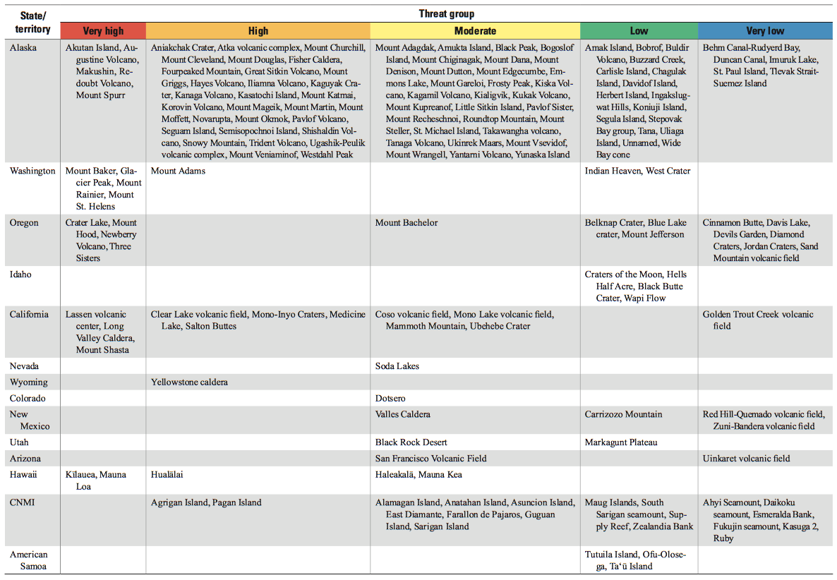
The U.S. Geological Survey systematically assesses U.S. volcanoes considered to be active or potentially active, and publishes a volcanic threat assessment that ranks the volcanoes based on 24 hazard and exposure factors. Last published in 2005, this 2018 update considers (1) field and laboratory research that adds or removes volcanoes from the list of potentially active volcanoes, and (2) updates the hazard and exposure factors used to produce a relative threat ranking of volcanoes.
Snip:
New activity/unrest was reported for 3 volcanoes between October 17 and 23, 2018. During the same period, ongoing activity was reported for 15 volcanoes.
New activity/unrest: Kerinci, Indonesia | Kuchinoerabujima, Ryukyu Islands (Japan) | Sarychev Peak, Matua Island (Russia).
Ongoing activity: Aira, Kyushu (Japan) | Dukono, Halmahera (Indonesia) | Ebeko, Paramushir Island (Russia) | Etna, Sicily (Italy) | Fuego, Guatemala | Ibu, Halmahera (Indonesia) | Kadovar, Papua New Guinea | Krakatau, Indonesia | Merapi, Central Java (Indonesia) | Piton de la Fournaise, Reunion Island (France) | Sabancaya, Peru | Santa Maria, Guatemala | Sheveluch, Central Kamchatka (Russia) | Turrialba, Costa Rica | Veniaminof, United States.

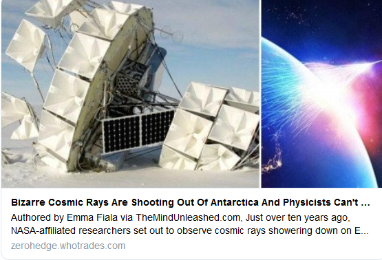
October 18, 2018
A fountain of high-energy particles that resembles an upside-down cosmic-ray shower is detected for the second time by the Antarctic Impulsive Transient Antenna.
Dave on Twitter
Bizarre Cosmic Rays Are Shooting Out Of Antarctica And Physicists Can't Explain It
23 Oct 2018
(MIAC #129) Politics of Divide Conquer to Protect the Flow of Food & Energy (741)
Adapt 2030 Published on Oct 26, 2018
Current: 10-27-18
Météo Pyrénées on Twitter
Andorra Lovers on Twitter
Last edited:
Recent blast from famous Krakatoa
posted on RT: Indonesia's Krakatau volcano creates its own lightning during magnificent eruption (VIDEO)
See also Anak Krakatau volcano news & eruption update (Indonesia > Sunda Strait) / 1-29 Oct, 2018 / VolcanoDiscoveryMother Nature produced a light show made of lava when Indonesia's Krakatau volcano erupted, scattering fiery specks and volcanic lightning into the night sky. The entire display was caught on video.
The beautiful footage shows the volcano, known for its violent eruptions, shoot ash and lava from its crater in a way that can only be described as mesmerizing. [...]
But what was even more dazzling was that the volcano managed to create its own lightning, a rare and remarkable occurrence that only takes place when the conditions of the eruption - from lava temperature to the size of the ash plumes - are just right.
The Krakatau volcano, situated in the Sunda Straight between the Indonesian islands of Java and Sumatra, has seen increased activity since June. It sits on the chain of active volcanoes along the Pacific rim that is often called the 'Ring of Fire.'
What i am missing here is an efford to connect the dots. Outbreaks are building up slowly, there is a statistical hazard, etc. Same with earthquakes, they build up with smaller quakes, then die down again. Nobody knows. Do not try to understand.
The electric universe theory gives two handles, with increasing viscosity of the lava due to bubbling in silicon rich magma exposed to cosmic rays, and a pulling pushing force of the solar wind on the earths crust having sometimes a trigger effect in fault zones when polarity alters.
Earth master and also duchsinse use a 3d program, picturing the earth, to feed the data into, to get a feel for the progession and placement of earth related events. That really helps imo, for it allows the imagination to work, and the intuition to focus on the state of the earth..
zak
The Living Force
Source of the great A.D. 1257 mystery eruption unveiled, Samalas volcano, Rinjani Volcanic Complex, Indonesia
The rest of the papers here:Based on ice core archives of sulfate and tephra deposition, one of the largest volcanic eruptions of the historic period and of the past 7,000 y occurred in A.D. 1257. However the source of this “mystery eruption” remained unknown. Drawing on a robust body of new evidence from radiocarbon dates, tephra geochemistry, stratigraphic data, a medieval chronicle, this study argues that the source of this eruption is Samalas volcano, part of the Mount Rinjani Volcanic Complex on Lombok Island, Indonesia. These results solve a conundrum that has puzzled glaciologists, volcanologists, and climatologists for more than three decades. In addition, the identification of this volcano gives rise to the existence of a forgotten Pompeii in the Far East.
Source of the great A.D. 1257 mystery eruption unveiled, Samalas volcano, Rinjani Volcanic Complex, Indonesia
The eruption investigation that marked the Middle Ages in video, i found only the french version:
Translated from Russian by Microsoft
On Kurila volcano Ebeko threw a pillar of ashes to a height of three kilometers: На Курилах вулкан Эбеко выбросил столб пепла на высоту три километра: кадры с места …
Translated from Spanish by Microsoft
POPOCATEPETL volcano imminent eruption? Population at risk, the other... via@YouTube

Salton Buttes lava domes: Mud volcano threatens railroad track and state highway, California
TW on November 02, 2018
Snip:
One of the mud geysers near the town of Niland, California's Imperial County, is growing rapidly, threatening nearby railroad track and state highway which may soon have to be closed.
This area consists of a group of volcanoes in the Niland Field, known as Salton Buttes, Salton Sea Mud Volcanoes and locally as the Davis-Schrimpf Seep Field. You can explore the area in detail using map below.
The field is located close to the southeastern rim of the Salton Sea and consists of about 7 km2 (4.3 mi2)-long row of five lava domes, named Mullet Island, North Red Hill, Obsidian Butte, Rock Hill and South Red Hill. They are closely associated with a fumarolic field and a geothermal field, and there is evidence of buried volcanoes underground.
According to officials, one of the mud geysers in the field recently moved about 18 m (60 feet) in just one day and is now threatening crucial infrastructure in the area.
The geyser is located approximately 1 km (0.6 miles) south of the intersection of SR -111 (Highway 111) and Gillespie Road in Imperial County and is releasing water and carbon dioxide.

Hawaii Volcano Eruption Emergency Proclamation Extended (Oct. 31, 2018)
Published on Oct 31, 2018 / 2:02
On Kurila volcano Ebeko threw a pillar of ashes to a height of three kilometers: На Курилах вулкан Эбеко выбросил столб пепла на высоту три километра: кадры с места …
Translated from Spanish by Microsoft
POPOCATEPETL volcano imminent eruption? Population at risk, the other... via
Salton Buttes lava domes: Mud volcano threatens railroad track and state highway, California
TW on November 02, 2018
Snip:
One of the mud geysers near the town of Niland, California's Imperial County, is growing rapidly, threatening nearby railroad track and state highway which may soon have to be closed.
This area consists of a group of volcanoes in the Niland Field, known as Salton Buttes, Salton Sea Mud Volcanoes and locally as the Davis-Schrimpf Seep Field. You can explore the area in detail using map below.
The field is located close to the southeastern rim of the Salton Sea and consists of about 7 km2 (4.3 mi2)-long row of five lava domes, named Mullet Island, North Red Hill, Obsidian Butte, Rock Hill and South Red Hill. They are closely associated with a fumarolic field and a geothermal field, and there is evidence of buried volcanoes underground.
According to officials, one of the mud geysers in the field recently moved about 18 m (60 feet) in just one day and is now threatening crucial infrastructure in the area.
The geyser is located approximately 1 km (0.6 miles) south of the intersection of SR -111 (Highway 111) and Gillespie Road in Imperial County and is releasing water and carbon dioxide.
Hawaii Volcano Eruption Emergency Proclamation Extended (Oct. 31, 2018)
Published on Oct 31, 2018 / 2:02
Translated from Russian by Microsoft
On Kurila volcano Ebeko threw a pillar of ashes to a height of three kilometers: На Курилах вулкан Эбеко выбросил столб пепла на высоту три километра: кадры с места …
Volcano Ebeko on Kuril Islands Spews Ash 2.8 Miles (VIDEO)
The volcano Ebeko on Paramushir Island, in Russia’s Kuril Islands archipelago, spewed out a column of ash to a height of 4.5 kilometers (2.8 miles), the press service of the Russian Emergencies Ministry's department in the Far Eastern Sakhalin Region said in a statement on Sunday.
"On November 4, the emergencies control center of the Russian Emergencies Ministry's department in the Sakhalin Region received information that the Ebeko volcano was seen spewing ash to a height of up to 4.5 kilometers. The plume of ash has moved to the northeast of the volcano, to a distance of up to five kilometers," the statement read.
The town of Severo-Kurilsk, located seven kilometer away from the volcano, has not experienced ash fall, the statement added.
According to the statement, the situation on the island is non-life threatening for local residents.
Ebeko awoke from dormancy in 2016 and has repeatedly spewn ash since then.
What i am missing here is an efford to connect the dots. Outbreaks are building up slowly, there is a statistical hazard, etc. Same with earthquakes, they build up with smaller quakes, then die down again. Nobody knows. Do not try to understand.
The electric universe theory gives two handles, with increasing viscosity of the lava due to bubbling in silicon rich magma exposed to cosmic rays, and a pulling pushing force of the solar wind on the earths crust having sometimes a trigger effect in fault zones when polarity alters.
Earth master and also duchsinse use a 3d program, picturing the earth, to feed the data into, to get a feel for the progession and placement of earth related events. That really helps imo, for it allows the imagination to work, and the intuition to focus on the state of the earth..
Hello cope, I think sometimes we fail to take into account the gravitational effect of the Earth and the Moon/Sun, which I have read somewhere can move the Earth's crust up to 30 cm. I'm sure this would loosen up a few of the fault lines and precipitate earthquakes and other volcanic activity. Couple this with other stimuli such as the solar wind and the electrical impact of the stream of positive protons from the sun and of course it will be virtually unpredictable, although I consider that "Dutchsinse" seems to be headed in the right direction with his theories.
Hello cope, I think sometimes we fail to take into account the gravitational effect of the Earth and the Moon/Sun, which I have read somewhere can move the Earth's crust up to 30 cm. I'm sure this would loosen up a few of the fault lines and precipitate earthquakes and other volcanic activity. Couple this with other stimuli such as the solar wind and the electrical impact of the stream of positive protons from the sun and of course it will be virtually unpredictable, although I consider that "Dutchsinse" seems to be headed in the right direction with his theories.
It is a nice subject to make a study on i think. i just mentioned 2 things, but there are dozens thinkable, moving in and out of relevance.
Some just put or drain pressure, some trigger, some block or ´grease´.
To see the solar wind influence, one could make a record of the quakes and eruptions in local time, as that gives the sun´s position, and then statistically analize the data, also against data of the intensity and fase of the solar winds cycle and magnetic components.
Some very longwave vibrations, modulations on cosmic waves, like the Betelgeuse blast, could resonate here and do all kinds of stuff.
Human emotions could have an effect in that category, too?
Dutch´ ideas, come to him as he juggles the 3d earth model, the standing wave in the magma, making equally spaced earthquakes on the ground on the crests, or an eruption if there happens to be a vulcano, do seem to make sense, and are entertaining, too.
Last edited:
Trending content
-

-

-
Thread 'Coronavirus Pandemic: Apocalypse Now! Or exaggerated scare story?'
- wanderingthomas
Replies: 30K