Volcanoes Erupting All Over

Underwater coastal eruptions and largest vent videos

Just came across these two youtube videos. Unfortunately there is very little information included with them concerning location , dates etc; but they seem indicative of increased underwater volcanic/venting 'opening up' activity. Imagine such phenomena on a much larger scale! :wow:

After some initial searching, I still haven't been able to obtain further info.


Undersea Volcano Eruptions Caught On Video:

https://www.youtube.com/watch?v=HZqsh5Cnl2o

Largest volcano vent found underwater:

https://www.youtube.com/watch?v=rAAZbge9f3Y
 
Re: Colima's volcano recent activity

Well, Colima's volcano had not stpped its activity, even though, had not been able to post every activity it had had, this recent one was after 2 days. http://www.sott.net/article/306542-Mexicos-Colima-volcano-erupts-again-spewing-smoke-and-ash-almost-2-miles-in-air


https://youtu.be/wPXBk1XxKls

The other day was reading about pilian like eruptions of the Popocateptl's at the prehispanic era, I hope we do not have the opportunity to see that.

Had able to just read the abstract's ones, though, like this one:
_http://geology.gsapubs.org/content/24/5/399.abstract said:
Repeated volcanic disasters in Prehispanic time at Popocatépetl, central Mexico: Past key to the future?
Claus Siebe1, Michael Abrams2, José Luis Macías1 and Johannes Obenholzner3

Abstract

The Holocene eruptive history of Popocatépetl volcano is characterized by recurrent voluminous Plinian eruptions every 1000 to 3000 yr, the most recent of which destroyed human settlements. Major eruptions occurred between 3195 and 2830 B.C., 800 and 215 B.C., and A.D. 675 and 1095. The three eruptions followed a similar pattern and started with minor ash fall and ash flows. The eruptions reached their peak with a main Plinian pulse that produced deposition of a pumice fall, the emplacement of hot ash flows, and finally extensive mudflows. [/b]Each time the area of devastation had become repopulated, before being devastated once again. During the last eruption several settlements, including Cholula (a major urban center), were inundated by lahars. A scenario of the possible recurrence of an eruption of similar magnitude, which would have disastrous consequences for the now highly populated areas around Popocatépetl, should be considered seriously in any volcano emergency contingency plan. This is especially important because more than one million people are living within a radius of 35 km around the volcano (the outskirts of Mexico City are at a distance of 40 km), and Popocatépetl resumed emitting ash on December 21, 1994, after decades of dormancy.
 
Re: Colima's volcano recent activity

At 10:10 am trembled in Guadalajara Mexico, we are 2 hours by car Colima Volcano. I am guessing if does it have to do with the revival activity of the volcano? The intensity quake was 5.6 degrees. Some school are been evacuated, but in other areas the people neither realize it....weird :cry:
 
Re: Colima's volcano recent activity

dulma said:
At 10:10 am trembled in Guadalajara Mexico, we are 2 hours by car Colima Volcano. I am guessing if does it have to do with the revival activity of the volcano? The intensity quake was 5.6 degrees. Some school are been evacuated, but in other areas the people neither realize it....weird :cry:

Not quite sure, although, I was reading yesterday the correlation between volcanic eruptions and earthquakes at the Earth Changes and the Human-Cosmic Connection book, so yes, perhaps to surely it is, there had been other earthquakes in the country as well more at Guerrero, Oaxaca and, the activity of the volcanoes had been ongoing.

According to National Seismologic (_http://www.ssn.unam.mx/) the earthquake was 20 km at Northeast of Tesistán, Jalisco, with a magnitude of 4.4, I suppose I am more worried or would be worried about the area of Tesistán itself, it had had cracks in the past, and all of the recent constructions at the north of the city of Guadalajara that are near the area ... mmm

Here _www.milenio.com/region/Grietas-riesgo-latente-Valle-Tesistan_0_557944260.html, explains that several cracks had been appearing through the years, UdeG university had documented around 14 since 1918 due to geological conditions and urbanization. -Spanish
 
Re: Colima's volcano recent activity

mabar said:
According to National Seismologic (_http://www.ssn.unam.mx/) the earthquake was 20 km at Northeast of Tesistán, Jalisco, with a magnitude of 4.4, I suppose I am more worried or would be worried about the area of Tesistán itself, it had had cracks in the past, and all of the recent constructions at the north of the city of Guadalajara that are near the area ... mmm

There was another one, according to National Seismologic.

_http://www.ssn.unam.mx/ultimos.html said:
Date Time Lat. Lon. Prf.(km) Mag Localizacion
15-12-15 11:49:48 20.94 -103.37 10.0 3.9 20 km al NORESTE de TESISTAN, JAL (second)

15-12-15 10:09:23 20.94 -103.37 10.0 4.4 20 km al NORESTE de TESISTAN, JAL
 
Re: Colima's volcano recent activity

This one was from Monday, Colima's volcano eruption and fireball (Geminids) from behind.

https://youtu.be/3l5gn4gtH-k

And these ones from photographer Tapiro are very impresive as well. http://es.sott.net/article/43154-Enfurecen-y-lanzan-fuego-el-Popo-y-el-Volcan-de-Colima
 
Shiveluch volcano erupting in Russia’s Far East

Shiveluch volcano erupting in Russia’s Far East

_http://tass.ru/en/science/845609

Columns of ash were raised up to five kilometers above the sea level, scientists say

PETROPAVLOVSK-KAMCHTASKY, December 21. /TASS/. Lava descending from the Shiveluch volcano in Russia’s Far East has raised columns of ash up to five kilometers above the sea level, scientists from the Kamchatka Volcanic Eruption Response Team (KVERT) told TASS on Monday.

"The volcano continues erupting. Lava has descended today from the top of the Young Shiveluch. Columns of ash were raised up to five kilometers above the sea level," scientists said adding that there is no threat to settlements in the area.

The ash cloud is drifting to the east and south-east, with the plume covering the area of around 15 kilometers.

The Russian Emergencies Ministry’s department in the Kamchatka region said that no ash falls were reported in the area.

An orange alert was issued over the eruption of the Shiveluch which can spew ash up to 10 kilometers above the sea level at any moment. Airlines that fly near the Shiveluch are recommended to change their routes. There are over 150 volcanos on the Kamchatka peninsula in Russia’s Far East, and up to 30 of them are active.

The Shiveluch is located some 450 kilometers (280 miles) to the north-east of the Kamchatka Peninsula’s largest city of Petropavlovsk-Kamchhatsky with the population of over 181,600 people. However, nearest residential areas are located within the distance of 50 kilometers (31 miles) from the Shiveluch, which had been regularly spewing out ash since 1980s.
 
Re: Colima's volcano recent activity

Between yesterday (23rd Dec) night and early today (24th Dec), Colima's volcano had activity.


Edit: images taken from webcamsdemexico
 

Attachments

  • 535051_977307555690369_5915078493593073797_n.jpg
    535051_977307555690369_5915078493593073797_n.jpg
    163.3 KB · Views: 47
  • 12392031_977494709004987_149238985403751989_n.jpg
    12392031_977494709004987_149238985403751989_n.jpg
    127.4 KB · Views: 44
Re: Shiveluch volcano erupting in Russia’s Far East

The Shiveluch volcano in Russia's Kamchatka erupted once again on Sunday, as the volcano's activity continues to grow, potentially leading to a major eruption.

Could This Be the Big One? Major Russian Volcano Erupts Again
http://sputniknews.com/russia/20160110/1032902304/kamchatka-volcano-eruption.html

The Shiveluch volcano in Russia's Kamchatka territory woke up on Sunday morning local time, releasing a plume seven kilometers up in the atmosphere, the Kamchatka Branch of the Russian Academy of Science's Geophysical Service said.

The Shiveluch volcano released ash plumes throughout 2015, at times releasing enough ash to carpet nearby towns. The new eruption led the Kamchatka Volcanic Eruption Response Team (KVERT) to issue an orange warning, meaning that while a major eruption is not imminent, it is nevertheless a danger to aircraft.

"According to video data, explosions sent ash up to 7 km [above sea level] on 2153 UTC on January 09. The ash plume extended to the west-northwest of the volcano," the warning issued by KVERT said.

The volcano continues to erupt, according to the response team. Seismologists have previously predicted that the volcano's activity would continue to rise over time.

"Explosive-extrusive eruption of the volcano continues. Ash explosions up to 32,800 ft (10 km) [above sea level] could occur at any time. Ongoing activity could affect international and low-flying aircraft," the KVERT warning also sai.
 
Volcano's activity in Mexico

Is not from Colima`s volcano, but is in country, that's why I changed the tittle.

Found this news that ... 0h-0h? ... I was wondering about the "Mexico Falls" ... it would be-I hope not- a quick answer, if the Trans-Mexican Volcanic Belt make all the volcanos within, "spring" up ..

_http://strangesounds.org/2016/01/bubbling-road-michoacan-mexico-next-eruption-michoacan-guanajuato-volcanic-field-video.html said:

Bubbling road in Michoacán, Mexico – Is the Michoacán–Guanajuato volcanic field about to erupt?

By Strange Sounds - Jan 17, 2016
This video filmed on January 12, 2016 is creepy --- yes it is

It shows the asphalt of a road in El Salitre, Michoacan literally bubbling, like a little volcano. Is the Michoacán–Guanajuato volcanic field about to erupt?

The Parícutín volcano is one of the major cinder cone of the Michoacán-Guanajuato volcanic field, in the Michoacán state section.

Can you please explain what’s going on there?

The Michoacán–Guanajuato volcanic field is located in central Mexico and covers an area of 200 kilometres (120 mi) x 250 kilometres (160 mi). It is a volcanic field that takes the form of a large cinder cone field, with 1400 vents, numerous shield volcanoes and maars.

The volcanic field is best known for the 18th century eruption of Jorullo volcano, and 20th century eruption of Parícutin volcano.

More about El Jorullo and Paricutín
_https://en.wikipedia.org/wiki/El_Jorullo said:
El Jorullo
El Jorullo is a cinder cone volcano in Michoacán, central Mexico, on the southwest slope of the central plateau, 33 miles (53 kilometers) southeast of Uruapan in an area known as the Michoacán-Guanajuato volcanic field. It is about 6 miles (10 km) east-northeast of La Huacana. Its current elevation is 4,360 ft (1,329 m). El Jorullo has four smaller cinder cones which have grown from its flanks. The vents of El Jorullo are aligned in a northeast to southwest direction. Lava from these vents cover nine square km around the volcano. Later eruptions produced lavas that had higher silica contents making them thicker than the earlier basalts and basaltic andesite lavas. El Jorullo's crater is about 1,300 by 1,640 feet (400 by 500 m) wide and 490 feet (150 m) deep.

El Jorullo is one of two known volcanoes to have developed in Mexico in recent history. The second, born about 183 years later, was named Parícutin after a nearby village that it eventually destroyed. Parícutin is about 50 miles (80 km) northwest of El Jorullo.

...

Parícutin and El Jorullo both rose in an area known for its volcanoes. Called the Trans-Mexican Volcanic Belt, the region stretches about 700 miles (1,120 km) from east to west across southern Mexico. The eruptive activity deposited a layer of volcanic rock some 6,000 feet thick, creating a high and fertile plateau. During summer months, the heights snag moisture-laden breezes from the Pacific Ocean; rich farmland, in turn, has made this belt the most populous region in Mexico.Though the region already boasted three of the country's four largest cities: Mexico City, Puebla, and Guadalajara (the area around Parícutin, some 200 miles west of the capital), it was still a peaceful backwater inhabited by Purépecha in the early 1940s.

_https://en.wikipedia.org/wiki/Par%C3%ADcutin said:
Paricutín
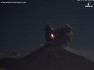
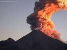
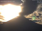
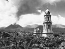
Parícutin (or Volcán de Parícutin, also accented Paricutín) is a dormant scoria-cone volcano located in the Mexican state of Michoacán, near the city of Uruapan and about 322 km west of Mexico City.The volcano surged suddenly from the cornfield of local farmer Dionisio Pulido in 1943, attracting both popular and scientific attention. This eruption presented the first occasion for modern science to document the full life cycle of an eruption of this type. During the 9-year life span of Parícutin, scientists sketched and mapped it, took samples as well as thousands of photographs of this volcano. By 1952, the volcano left a 424 meter high cone and significantly damaged a 233 km2 area with the ejection of stone, ash and lava. Three people were killed, two towns were completely evacuated and buried by lava and three others were heavily affected. Hundreds of people had to be permanently relocated, with two new towns created to accommodate the migration of people. Although the area still remains highly active volcanically, Parícutin itself is quiet and has become a tourist attraction, with people climbing the volcano itself and visiting the hardened-lava covered ruins of the San Juan Parangaricutiro Church. Parícutin is one of the Seven Natural Wonders of the World as assigned by CNN.

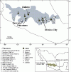
The volcano lies on, and is a product of, the Trans-Mexican Volcanic Belt, which runs 900km west to east across central Mexico. It includes the Sierra Nevada mountain range, (a set of extinct volcanoes) as well as thousands of cinder cones and volcanic events. Volcanic activity here has created the Central Mexican Plateau, and rock deposits up to 1.8km deep.It has also created fertile soils and some of Mexico’s most productive farmland.[8]The volcanic activity here is a result of the subduction of the Rivera and Cocos plates along the Middle America Trench.[9] More specifically, the volcano is the youngest of the approximately 1,400 volcanic vents of the Michoacán-Guanajuato volcanic field, a 40,000km2 basalt plateau, filled with scoria cones, like Parícutin, along with small shield volcanoes, maars, tuff rings and lava domes.[10][9] Scoria cones are the most common type of volcano in Mexico, appearing suddenly, and building a cone-shaped mountain with steep slopes before going extinct, with Parícutin's immediate predecessor being Jorullo, also in Michoacán, which arose in 1759.[8][11]

Currently the crater of the volcano is about 200 meters across and it is possible to both climb the volcano and walk around the entire perimeter.[7] Although classified as extinct by scientists, it is still hot, and seeping rainwater reacts with this heat so that the cone still emits steam in various streams.[12][7][13] However, the forces that created the volcano are still active. In 1997 there was a vigorous swarm of 230 earthquakes with five above 3.9 in the Paricutin area due to tectonic movement.[9] There were some reports of rumbling in 1995 and of black steam and rumbling in 1998.[13] In the summer of 2006, there was another major volcanic earthquake swarm, with over 300 located near the volcano, indicating magma movement, but with no eruption at Paricutin or anywhere else.

Image taken from here _http://www.oikos.unam.mx/atbc/english/San_Juan_Tour.htm
 

Attachments

  • image006-sjt.gif
    image006-sjt.gif
    21.3 KB · Views: 34
Re: Kamchatka's volcanoes activity

Kamchatka volcano spews ash to height of 8 km

http://tass.ru/en/science/850501

An "orange" code of warning for the aviation has been issued, and travel companies have been asked not to organize tours to the areas close to the Zhupanovsky volcano

PETROPAVLOVSK-KAMCHATSKY, January 19. /TASS/. The Zhupanovsky volcano in Russia’s Far Eastern Kamchatka Peninsula on Tuesday released ash to the height of 8 kilometers above the sea level after almost two months of relative calm, a member of the local group of the Institute of Volcanology and Seismology has said.

"Today at around 4.30 p.m. local time [3.30 a.m. GMT] the Zhupanovsky volcano spewed ash to the height of up to 8 kilometers [5 miles] above the sea level. The ash column could be seen with the naked eye from Petropavlovsk-Kamchatsky and some other settlements," the scientist said.

Experts said the ash cloud spreads in the eastern direction towards the Pacific Ocean. The populated areas are currently not under threat. "At the moment, the ash cloud has spread to 20 kilometers and it continues moving towards the ocean," the member of the group said.

An "orange" code of warning for the aviation has been issued. Travel companies have been asked not to organize tours to the areas close to the Zhupanovsky volcano.

The Aviation Color Codes reflect four levels of danger posed for civilian aircraft overflying areas adjacent to volcanoes and range from ‘Green’ to ‘Red’ codes. According to the International Airways Volcano Watch system (IAVW) the ‘Orange’ code stands for "Volcano is exhibiting heightened unrest with increased likelihood of eruption" or "Volcanic eruption is underway with no or minor ash emission."

The Zhupanovsky volcano is located in eastern Kamchatka, some 70 kilometers north of Petropavlovsk-Kamchatsky. Zhupanovsky is one of the least studied volcanoes in the region despite its proximity to a large city. It is a complex volcano composed of four overlapping cones aligned on a roughly east-west oriented axis, with the highest cone reaching 2,958 meters high, and the lowest one being 2,505 meters high.
 
Re: Colima's volcano recent activity

Past days of Colima's and Popocatepetl's volcano activity


https://youtu.be/YHlxYuYSAGM


https://youtu.be/TgEuHvuF7Tc

Right now from Popocatepetl's, image from webcamsdemexico.

And last one is from the church buried after Paricutin's appearance in 1943, image taken from here _http://www.mexonline.com/paricutinvolcano.htm

Add: note, we had been having colorful sunsets and sunrises that, I am no longer surprise after reading about the correlation of colors and volcanic activity http://www.sott.net/article/233996-Volcanic-Sunsets-For-Europe

like this one, the volcanoes Popocateptl and Iztaccihuatl seen from Puebla city, January 18th, 2016
 

Attachments

  • livepopo.jpg
    livepopo.jpg
    41.4 KB · Views: 175
  • paricutin-church.jpg
    paricutin-church.jpg
    27.5 KB · Views: 201
  • 1824-180116.jpg
    1824-180116.jpg
    41.4 KB · Views: 170
Re: Colima's volcano recent activity

Due to latest Popocatepetl's activity, the airport of Puebla closed for several hours. _http://www.abc.net.au/news/2016-01-26/volcano-ash-temporarily-closes-central-mexico-airport/7115324
 
Back
Top Bottom