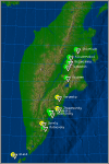
Last time, the volcano erupted in November last year when the Catania airport was shut down due to lava and ash.
Italian volcano Etna has awakened. Lava started gushing from the 3,350 metre mountain and the surrounding Sicily area, without any residents, was shaken by 200 earthquakes measuring 4.2 on the Richter scale.
Last time, the volcano erupted in November last year when the Catania airport was shut down due to lava and ash. This is the highest active volcano in Europe, according to the Palermo geophysics Institute.
Published: May 11, 2008
You are using an out of date browser. It may not display this or other websites correctly.
You should upgrade or use an alternative browser.
You should upgrade or use an alternative browser.
Volcanoes Erupting All Over
- Thread starter Laura
- Start date
Eruptions Updated
Found this interesting website, _http://www.geobulletin.org/index.php?date=2012-04-16 while looking for a news in English, regarding update from Popocatépetl volcano since it had activity at least around this month and today, from what I heard on the news, there is lava on the dome, schools and roads were closed.
In this website linked from the above there is a resume of the latest eruptions.
_http://www.wired.com/wiredscience/2012/04/eruption-update-for-april-16-2012-costa-rica-mexico-italy-alaska-and-iceland/
Iarrthoir Firinne
Jedi
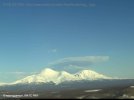
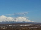
Volcanic Eruption in New Zealand
Poor little New Zealand is coping it again, this time with a volcanic eruption - Mt Tongariro.
I copied this article from the NZ Herald:
- Mt Tongariro erupted at 11.50pm last night, hurling rocks up to 1km.
- Ash cloud drifting to the east of Tongariro, landing as far as Napier city
- SH1 and SH46 have reopened. Flights to and from Napier cancelled, while other North Island services have been delayed.
- GNS: It was a hydrothermal-driven eruption, rather the magmatic
- It was the first eruption in more than a century
- Turoa and Whakapapa skifields remain open
Volcanic activity on Mt Tongariro could continue for "weeks, months or even years", a volcanologist says.
Rocks and ash were thrown up to a kilometre from the central North Island, which last night erupted for the first time in more than a century.
The eruption forced the closure of roads and disrupted flights, while nearby residents were advised to stay indoors.
Ash has reached as far as the Napier CBD, as the ash plume drifted to the east of the mountains over the course of the morning.
The volcanic alert level for Mt Tongariro has risen from 1 to 2, while the aviation colour code has been raised to red.
Brent Crowe of the Bay of Plenty police told the press conference that ash and rock was ejected from the volcano in a 1km radius.
The police focus remained on public safety, he said.
Three Department of Conservation huts on Mt Tongariro are being cleared.
All locals residents were urged to remain calm and check water supplies to make sure they were not contaminated.
The eruption was reported to police just before midnight by a member of the public who reported seeing explosions on the northern face of the mountain.
The witness told police the eruption had created "a new hole in the side of the mountain".
Police had received no reports of injury or damage, but the Ministry of Civil Defence & Emergency Management advised people in affected areas to stay indoors.
There have been no mandatory evacuations ordered by authorities, but some residents have chosen to leave the area.
A "potential threat to New Zealand advisory" is in place for Waikato, Hawkes Bay, Gisborne, Manawatu-Wanganui, Bay of Plenty and Taranaki.
Local resident David Bennett said this eruption was "just about as spectacular" as Ruapehu's eruption in 1995. Mr Bennett lives about 6km away from the eruption on the southern shores of Lake Rotoaira
HYDROTHERMAL ERUPTION
GNS Science volcanologist Brad Scott told reporters it had not detected any increased activity in the 12-14 hours before the eruption.
"There has been no escalation coming into the eruption and we've seen no escalation post the eruption," Mr Scott said. "The eruption gave us no warning ... it just crept up on us."
A flyover of the mountain this morning revealed a steam plume coming from the mountain but there was no indication of volcanic ash this morning.
Scientists were unable to see the immediate impact of the eruption on the mountain because of bad weather and low cloud.
"We were unable to see the impact immediately around the craters so we still can't confirm just which crater the eruptions occurred from,'' he said.
"We've had a small-scale volcanic eruption. It appears to be driven in the hydrothermal rather than the magmatic process, there's been an ash plume, there's been ash-fall down wind.''
Mr Scott said the eruptions are expected to continue for "at least days".
Auckland University volcanologist Phil Shane said the small eruption this morning could signal the start of a pattern of explosions at the central North Island mountain.
He drew a comparison to the Caribbean volcano Montserrat, which rumbled to life in 1995 and has continued to erupt until today.
A more violent eruption in the coming days or a drop off in all volcanic activity was also possible, Associate Professor Shane said.
"We don't know how long it could go. It could be a one off or it could go weeks, months years or even a decade."
ROADS
Police closed State Highway 1 and State Highway 46 as a precautionary matter overnight but they have since reopened.
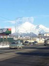
New Zealand Herald reporter Jamie Morton said the ash this morning on SH46 at Lake Rotoaira, just north of Tongariro is a "thick, clay-like mud", about half a centimetre thick.
"It's just carpeted everything, all the fields, cars, trees - the whole landscape looks quite murky and grey," he said.
"Roofs in this area, they're all absolutely coated in this ash."
Contractors are currently sweeping the ash from State Highway 46, Mr Morton said.
"There is also quite a noticeable smell ... quite a murky smell. We've had reports in Waiouru that there is a sulphur-like smell in the area. That is not the case here."
Truck driver Bryn Rodda was one of the first to see the eruption.
"As I was coming up from Waiouru .... I saw this beautiful, big cloud and I thought 'gee that looks like a volcanic plume'. Just as I thought that there was a great big orange flash," he told National Radio.
He said he saw a thick cloud of ash develop and fine grey ash started falling.
"(The cloud) looked like a fist, basically, at an angle across the sky. About the wrist section of the fist there was an orange ball of flash I could see.
"It was quite impressive."
AVIATION
Air New Zealand has announced all flights in and out of Hawke's Bay airport are cancelled today due to the ash cloud from the Mt Tongariro eruption.
Further regional flights to and from destinations east of Tongariro could be delayed or cancelled and passengers should check its website for updates.
Captain David Morgan, Air New Zealand general manager airline operations and safety and chief pilot, said the airline is working with the relevant authorities to make adjustments to flight routes to ensure aircraft remain clear of any ash.
"We will not fly through ash and are constantly taking guidance from the CAA and the MetService to ensure we can continue to carry passengers where safe routes and altitudes are available."
Civil Aviation Authority manager of meteorology Peter Lechner said that ash can build up in the turbines of aeroplanes and helicopters, causing engines to stall.
"It can result in significant flight risk."
FARMING
Federated Farmers said initial reports indicated the eruption had had little impact on farm pasture or stock drinking water.
Four farms had been contacted in different parts of Hawkes Bay, including one on the Taupo-Napier highway, and they were yet to report any ash.
"While we are waiting on reports from our Ruapehu province, GNS predicted ashfall indicates it will largely fall on National Park or forested areas," the group said in a statement.
SKIFIELDS
Skifields on Mount Ruapehu were open this morning, with operators saying the eruption of Mt Tongariro posed no threat to the Whakapapa and Turoa ski areas.
The volcanic vents on Tongariro, Ngauruhoe, and Ruapehu were independent of each other and there was no reason or indication of volcanic activity on Ruapehu, a Mt Ruapehu spokesman said.
"The Te Maari crater where the eruption occurred is at least 20km away from the ski area."
The ash was blowing to the east, away from the skifields.
EARTHQUAKES AND ERUPTION
A joint agency incident management centre has been established at the Whakapapa Department of Conservation Visitor Centre.
GNS volcanologist Brad Scott told Radio New Zealand the eruption began from the Te Maari craters at the north end of Mt Tongariro at 11.50pm yesterday.
An earthquake lasting about five minutes accompanied the eruption and residents reportedly heard the explosions.
"When they went outside to have a look they saw the volcano starting to erupt. They saw incandescent blocks - glowing hot blocks - and they saw an eruption column being developed and within about five minutes they were experiencing a light local ash fall."
GNS had been aware of some issues at Mt Tongariro for a few weeks, "but to be honest we didn't see anything in the latest data up until last night that indicated it was ready to erupt", Mr Scott said.
He said there was likely to be further activity.
"There's not showing any escalation - the earthquake activity hasn't increased or anything like that - but we would probably anticipate some more activity now that the craters have broken through."
Mt Tongariro last erupted between 1896 and 1897.
WEATHER AND AREAS AFFECTED
Weatherwatch said where the ash would go depended on the wind.
"We've updated our wind predictions - made more difficult by the fact a large low from the Tasman Sea is expected to cross over Central Plateau. The winds around the centre of the low are very light - which is good news for any further potential ash clouds, as it would decrease the chances of significant drift," the forecaster said in an update.
---
Mt Tongariro eruption: Where will the ash go?
---
Civil defence spokesman Vince Cholewa told NewstalkZB ash could reach those living in Waikato, Hawkes Bay, Gisborne, Manawatu-Wanganui, Bay of Plenty and Taranaki.
"The advice to people is to stay indoors, because volcanic ash can obviously be a health hazard, if they're indoors please close windows and doors to try and limit the entry of ash."
Mr Cholewa said not all areas alerted were affected by ash but that situation could change.
"We're working actively with GNS Science who operate the monitoring equipment on the mountains, and with police so all the information from the ground is being gathered, and decisions will be based on that information.
"Evacuations have not been ordered, please listen to the radio for advice from local authorities and police, any evacuations would be issued at that level, and based on the evidence from GNS Science."
Police say the wider community's health is not currently at risk from the eruption of Mt Tongariro.
There was no need for the wider community to remain indoors with closed doors and windows.
"At this time the only risk is minimal and would only be to people in the local vicinity of the eruption who have a predisposition to respiratory issues.
"The only other advice is in relation to water supplies of the rural community in the immediate local area," police said in a statement.
WHITE ISLAND
New Zealand's other high profile active volcano, White Island, also had its alert level raised from 1 to 2 on Monday after a small eruption was recorded in its crater lake.
GNS Science said the increased activity on White Island is not related to the Tongariro eruption.
Poor little New Zealand is coping it again, this time with a volcanic eruption - Mt Tongariro.
I copied this article from the NZ Herald:
- Mt Tongariro erupted at 11.50pm last night, hurling rocks up to 1km.
- Ash cloud drifting to the east of Tongariro, landing as far as Napier city
- SH1 and SH46 have reopened. Flights to and from Napier cancelled, while other North Island services have been delayed.
- GNS: It was a hydrothermal-driven eruption, rather the magmatic
- It was the first eruption in more than a century
- Turoa and Whakapapa skifields remain open
Volcanic activity on Mt Tongariro could continue for "weeks, months or even years", a volcanologist says.
Rocks and ash were thrown up to a kilometre from the central North Island, which last night erupted for the first time in more than a century.
The eruption forced the closure of roads and disrupted flights, while nearby residents were advised to stay indoors.
Ash has reached as far as the Napier CBD, as the ash plume drifted to the east of the mountains over the course of the morning.
The volcanic alert level for Mt Tongariro has risen from 1 to 2, while the aviation colour code has been raised to red.
Brent Crowe of the Bay of Plenty police told the press conference that ash and rock was ejected from the volcano in a 1km radius.
The police focus remained on public safety, he said.
Three Department of Conservation huts on Mt Tongariro are being cleared.
All locals residents were urged to remain calm and check water supplies to make sure they were not contaminated.
The eruption was reported to police just before midnight by a member of the public who reported seeing explosions on the northern face of the mountain.
The witness told police the eruption had created "a new hole in the side of the mountain".
Police had received no reports of injury or damage, but the Ministry of Civil Defence & Emergency Management advised people in affected areas to stay indoors.
There have been no mandatory evacuations ordered by authorities, but some residents have chosen to leave the area.
A "potential threat to New Zealand advisory" is in place for Waikato, Hawkes Bay, Gisborne, Manawatu-Wanganui, Bay of Plenty and Taranaki.
Local resident David Bennett said this eruption was "just about as spectacular" as Ruapehu's eruption in 1995. Mr Bennett lives about 6km away from the eruption on the southern shores of Lake Rotoaira
HYDROTHERMAL ERUPTION
GNS Science volcanologist Brad Scott told reporters it had not detected any increased activity in the 12-14 hours before the eruption.
"There has been no escalation coming into the eruption and we've seen no escalation post the eruption," Mr Scott said. "The eruption gave us no warning ... it just crept up on us."
A flyover of the mountain this morning revealed a steam plume coming from the mountain but there was no indication of volcanic ash this morning.
Scientists were unable to see the immediate impact of the eruption on the mountain because of bad weather and low cloud.
"We were unable to see the impact immediately around the craters so we still can't confirm just which crater the eruptions occurred from,'' he said.
"We've had a small-scale volcanic eruption. It appears to be driven in the hydrothermal rather than the magmatic process, there's been an ash plume, there's been ash-fall down wind.''
Mr Scott said the eruptions are expected to continue for "at least days".
Auckland University volcanologist Phil Shane said the small eruption this morning could signal the start of a pattern of explosions at the central North Island mountain.
He drew a comparison to the Caribbean volcano Montserrat, which rumbled to life in 1995 and has continued to erupt until today.
A more violent eruption in the coming days or a drop off in all volcanic activity was also possible, Associate Professor Shane said.
"We don't know how long it could go. It could be a one off or it could go weeks, months years or even a decade."
ROADS
Police closed State Highway 1 and State Highway 46 as a precautionary matter overnight but they have since reopened.
New Zealand Herald reporter Jamie Morton said the ash this morning on SH46 at Lake Rotoaira, just north of Tongariro is a "thick, clay-like mud", about half a centimetre thick.
"It's just carpeted everything, all the fields, cars, trees - the whole landscape looks quite murky and grey," he said.
"Roofs in this area, they're all absolutely coated in this ash."
Contractors are currently sweeping the ash from State Highway 46, Mr Morton said.
"There is also quite a noticeable smell ... quite a murky smell. We've had reports in Waiouru that there is a sulphur-like smell in the area. That is not the case here."
Truck driver Bryn Rodda was one of the first to see the eruption.
"As I was coming up from Waiouru .... I saw this beautiful, big cloud and I thought 'gee that looks like a volcanic plume'. Just as I thought that there was a great big orange flash," he told National Radio.
He said he saw a thick cloud of ash develop and fine grey ash started falling.
"(The cloud) looked like a fist, basically, at an angle across the sky. About the wrist section of the fist there was an orange ball of flash I could see.
"It was quite impressive."
AVIATION
Air New Zealand has announced all flights in and out of Hawke's Bay airport are cancelled today due to the ash cloud from the Mt Tongariro eruption.
Further regional flights to and from destinations east of Tongariro could be delayed or cancelled and passengers should check its website for updates.
Captain David Morgan, Air New Zealand general manager airline operations and safety and chief pilot, said the airline is working with the relevant authorities to make adjustments to flight routes to ensure aircraft remain clear of any ash.
"We will not fly through ash and are constantly taking guidance from the CAA and the MetService to ensure we can continue to carry passengers where safe routes and altitudes are available."
Civil Aviation Authority manager of meteorology Peter Lechner said that ash can build up in the turbines of aeroplanes and helicopters, causing engines to stall.
"It can result in significant flight risk."
FARMING
Federated Farmers said initial reports indicated the eruption had had little impact on farm pasture or stock drinking water.
Four farms had been contacted in different parts of Hawkes Bay, including one on the Taupo-Napier highway, and they were yet to report any ash.
"While we are waiting on reports from our Ruapehu province, GNS predicted ashfall indicates it will largely fall on National Park or forested areas," the group said in a statement.
SKIFIELDS
Skifields on Mount Ruapehu were open this morning, with operators saying the eruption of Mt Tongariro posed no threat to the Whakapapa and Turoa ski areas.
The volcanic vents on Tongariro, Ngauruhoe, and Ruapehu were independent of each other and there was no reason or indication of volcanic activity on Ruapehu, a Mt Ruapehu spokesman said.
"The Te Maari crater where the eruption occurred is at least 20km away from the ski area."
The ash was blowing to the east, away from the skifields.
EARTHQUAKES AND ERUPTION
A joint agency incident management centre has been established at the Whakapapa Department of Conservation Visitor Centre.
GNS volcanologist Brad Scott told Radio New Zealand the eruption began from the Te Maari craters at the north end of Mt Tongariro at 11.50pm yesterday.
An earthquake lasting about five minutes accompanied the eruption and residents reportedly heard the explosions.
"When they went outside to have a look they saw the volcano starting to erupt. They saw incandescent blocks - glowing hot blocks - and they saw an eruption column being developed and within about five minutes they were experiencing a light local ash fall."
GNS had been aware of some issues at Mt Tongariro for a few weeks, "but to be honest we didn't see anything in the latest data up until last night that indicated it was ready to erupt", Mr Scott said.
He said there was likely to be further activity.
"There's not showing any escalation - the earthquake activity hasn't increased or anything like that - but we would probably anticipate some more activity now that the craters have broken through."
Mt Tongariro last erupted between 1896 and 1897.
WEATHER AND AREAS AFFECTED
Weatherwatch said where the ash would go depended on the wind.
"We've updated our wind predictions - made more difficult by the fact a large low from the Tasman Sea is expected to cross over Central Plateau. The winds around the centre of the low are very light - which is good news for any further potential ash clouds, as it would decrease the chances of significant drift," the forecaster said in an update.
---
Mt Tongariro eruption: Where will the ash go?
---
Civil defence spokesman Vince Cholewa told NewstalkZB ash could reach those living in Waikato, Hawkes Bay, Gisborne, Manawatu-Wanganui, Bay of Plenty and Taranaki.
"The advice to people is to stay indoors, because volcanic ash can obviously be a health hazard, if they're indoors please close windows and doors to try and limit the entry of ash."
Mr Cholewa said not all areas alerted were affected by ash but that situation could change.
"We're working actively with GNS Science who operate the monitoring equipment on the mountains, and with police so all the information from the ground is being gathered, and decisions will be based on that information.
"Evacuations have not been ordered, please listen to the radio for advice from local authorities and police, any evacuations would be issued at that level, and based on the evidence from GNS Science."
Police say the wider community's health is not currently at risk from the eruption of Mt Tongariro.
There was no need for the wider community to remain indoors with closed doors and windows.
"At this time the only risk is minimal and would only be to people in the local vicinity of the eruption who have a predisposition to respiratory issues.
"The only other advice is in relation to water supplies of the rural community in the immediate local area," police said in a statement.
WHITE ISLAND
New Zealand's other high profile active volcano, White Island, also had its alert level raised from 1 to 2 on Monday after a small eruption was recorded in its crater lake.
GNS Science said the increased activity on White Island is not related to the Tongariro eruption.
Silveryblue
Jedi
Re: Volcanic Eruption in New Zealand
And now we have 3
Underwater volcano Monowai is probably responsible for a Belgium sized float of pumice 600 odd miles Northwest of Auckland.
Rock' & Rollin downunder
http://news.tangatawhenua.com/archives/18727
And now we have 3
Underwater volcano Monowai is probably responsible for a Belgium sized float of pumice 600 odd miles Northwest of Auckland.
Rock' & Rollin downunder
http://news.tangatawhenua.com/archives/18727
Iarrthoir Firinne
Jedi
Re: Volcanic Eruption in New Zealand
Yikes, too right!
For such a small country it certainly has it's share of living volcanoes!
I remember learning in school about the eruption of Mt Tarawera in 1886, which destroyed the famous pink and white terraces (the 8th wonder of the world). The explosions were apparently heard as far away as Auckland to the North and Christchurch to the South!
s-kur
Jedi Council Member
Re: Kamchatka's volcanoes activity
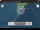
Source: ___http://www.kscnet.ru/ivs/kvert/van/index.php?type=1
1) VOLCANO OBSERVATORY NOTICE FOR AVIATION (VONA)
(2) Issued: 20141125/0301Z
(3) Volcano: Zhupanovsky (CAVW #300120)
(4) Current Aviation Color Code: ORANGE
(5) Previous Aviation Color Code: red
(6) Source:KVERT
(7) Notice Number: 2014-17
(8) Volcano Location: N 53 deg 35 min E 159 deg 8 min
(9) Area: Kamchatka, Russia
(10) Summit Elevation: 9702.24 ft (2958 m)
(11) Volcanic Activity Summary: Explosive eruption of the volcano continues but its activity decreased. According to satellite data, ash plumes continues to drift about 60 km to the south-east (153 degrees azimuth) of the volcano at 0155 UTC on November 25. Ash plumes are drifting over Nalychevo Vallew, outside towns and villages.
Explosive eruption of the volcano continues. Ash explosions up to 32,800 ft (10 km) a.s.l. could occur at any time. Ongoing activity could affect international and low-flying aircraft.
(12) Volcanic cloud height: 11480-13120 ft (3500-4000 m) a.s.l.
Source: ___http://www.kscnet.ru/ivs/kvert/van/index.php?type=1
Attachments
Re: Kamchatka's volcanoes activity
Thank you, s-kur. Btw, do you have any place where you and others can go in case of an emergency? Are there any official evacuation plans, or maybe you have relatives or friends that you can go to if one of those volcanoes will suddenly erupt? It seems like there are several close to your location, so thinking about this probably would be wise.
Thank you, s-kur. Btw, do you have any place where you and others can go in case of an emergency? Are there any official evacuation plans, or maybe you have relatives or friends that you can go to if one of those volcanoes will suddenly erupt? It seems like there are several close to your location, so thinking about this probably would be wise.
Re: Kamchatka's volcanoes activity
Yes, thanks s-kur. What do the local specialists predict? You say that the level is lower now, hopefully it will not intensify again. I read that the seismological activity also increased in the area, so it's not only volcanoes?
Yes, thanks s-kur. What do the local specialists predict? You say that the level is lower now, hopefully it will not intensify again. I read that the seismological activity also increased in the area, so it's not only volcanoes?
s-kur
Jedi Council Member
Re: Kamchatka's volcanoes activity
I don't aware about such a places and have not seen an evacuation plan...I think it doesn't exist :) Anyway, without jokes, you're right and I have to find it out. Ministry of Emergency Situations of Kamchatka only warn and explain safety measures in case of eruption with "ash precipitations". The only places I might go is my native island Paramushir, but since its transport connection is bad (helicopters and ships) it might difficult to go there ..in case of an emergency. As local says "Life on gunpowder keg" :)
Local scientists say nothing exciting. Yes, volcanoes just slightly smoking, but it might become worse at any moment. Regarding seismological activity here an actual information
The last earthquake 5.7M I have felt as strong occured in october
Keit said:Thank you, s-kur. Btw, do you have any place where you and others can go in case of an emergency? Are there any official evacuation plans, or maybe you have relatives or friends that you can go to if one of those volcanoes will suddenly erupt? It seems like there are several close to your location, so thinking about this probably would be wise.
I don't aware about such a places and have not seen an evacuation plan...I think it doesn't exist :) Anyway, without jokes, you're right and I have to find it out. Ministry of Emergency Situations of Kamchatka only warn and explain safety measures in case of eruption with "ash precipitations". The only places I might go is my native island Paramushir, but since its transport connection is bad (helicopters and ships) it might difficult to go there ..in case of an emergency. As local says "Life on gunpowder keg" :)
Siberia said:Yes, thanks s-kur. What do the local specialists predict? You say that the level is lower now, hopefully it will not intensify again. I read that the seismological activity also increased in the area, so it's not only volcanoes?
Local scientists say nothing exciting. Yes, volcanoes just slightly smoking, but it might become worse at any moment. Regarding seismological activity here an actual information
The last earthquake 5.7M I have felt as strong occured in october
Attachments
s-kur
Jedi Council Member
Re: Kamchatka's volcanoes activity
VONA/KVERT DAILY REPORT
Kamchatkan and Northern Kuriles Volcanic Activity
December 09, 2014, all time is UTC
SHEVELUCH VOLCANO (CAVW #300270)
56.64 N, 161.32 E; Elevation 10768 ft (3283 m), the dome elevation ~8200 ft (2500 m)
Aviation Color Code is ORANGE
A growth of the lava dome continues, moderate ash explosions, fumarolic activity and incandescence of the dome summit and hot avalanches accompanies this process. Satellite data showed a thermal anomaly over the lava dome.
ZHUPANOVSKY VOLCANO (CAVW #300120)
53.59 N, 159.15 E; Elevation 9702 ft (2958 m)
Aviation Color Code is ORANGE
A moderate activity of the volcano continues. Satellite data showed a thermal anomaly over the volcano.
BEZYMIANNY VOLCANO (CAVW #300250)
55.97 N, 160.6 E; Elevation 9453 ft (2882 m)
Aviation Color Code is YELLOW
A weak seismic activity of the volcano was registering. Satellite data showed a weak thermal anomaly over the volcano.
KARYMSKY VOLCANO (CAVW #300130)
54.05 N, 159.44 E; Elevation 4874 ft (1486 m)
Aviation Color Code is YELLOW
A moderate seismic activity of the volcano was registering. Satellite data showed the volcano was quiet or obscured by clouds.
(1) VOLCANO OBSERVATORY NOTICE FOR AVIATION (VONA)
(2) Issued: 20141125/0301Z
(3) Volcano: Zhupanovsky (CAVW #300120)
(4) Current Aviation Color Code: ORANGE
(5) Previous Aviation Color Code: red
(6) Source: KVERT
(7) Notice Number: 2014-17
(8) Volcano Location: N 53 deg 35 min E 159 deg 8 min
(9) Area: Kamchatka, Russia
(10) Summit Elevation: 9702.24 ft (2958 m)
(11) Volcanic Activity Summary: Explosive eruption of the volcano continues but its activity decreased. According to satellite data, ash plumes continues to drift about 60 km to the south-east (153 degrees azimuth) of the volcano at 0155 UTC on November 25. Ash plumes are drifting over Nalychevo Vallew, outside towns and villages.
Explosive eruption of the volcano continues. Ash explosions up to 32,800 ft (10 km) a.s.l. could occur at any time. Ongoing activity could affect international and low-flying aircraft.
(12) Volcanic cloud height: 11480-13120 ft (3500-4000 m) a.s.l.
VONA/KVERT Operative Report: Karymsky volcano
Issued: 20141210/0203Z
Volcano: Karymsky (CAVW #300130)
Aviation Color Code: YELLOW
Source: KVERT
Notice Number: 2014/94
Volcano Location: 54.05 N, 159.44 E
Area: Kamchatka, Russia
Summit Elevation : 4874.08 ft (1486 m)
Height of ash plume : 14760 ft (4.5 km) a.s.l.
Time and method of ash plume height determination: 20141210/0147Z – Visual data
Distance of ash plume of the volcano: 19 mi (30 km)
Direction of ash plume or ash cloud drift from the volcano: West
Time and method of ash plume observation: 20141210/0147Z – Visual data
Eruption is continuing
Remarcs: According to the data by pilots of helicopter (AMC Elizovo), explosions from Karymsky volcano raise up to 4.5 km a.s.l. and ash plumes are extending to the west of the volcano.
s-kur
Jedi Council Member
Re: Kamchatka's volcanoes activity
VONA/KVERT Operative Report: Sheveluch volcano
Issued: 20141211/2125Z
Volcano: Sheveluch (CAVW #300270)
Aviation Color Code: ORANGE
Source: KVERT
Notice Number: 2014/95
Volcano Location: 56.64 N, 161.32 E
Area: Kamchatka, Russia
Summit Elevation : 10768.24 ft (3283 m)
Height of ash plume : 6560-9840 ft (2-3 km) a.s.l.
Time and method of ash plume height determination: 20141211/1942Z – NOAA 18 (4m5)
Distance of ash plume of the volcano: 226 mi (364 km)
Direction of ash plume or ash cloud drift from the volcano: East-South-East
Time and method of ash plume observation: 20141211/1942Z – NOAA 18 (4m5)
Start time of explosion and how determined: 20141211/1447Z – Seismic data
Duration of explosion (if it known): ~ 23 minutes
Eruption is continuing
Remarcs: According to satellite data, big ash cloud (100x91 km) are near Kamchatsky Peninsula on the height about 2 km a.s.l. and an ash cloud (36x22 km) over Bering Island on the height about 3 km a.s.l.
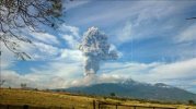
A little info from wikipedia
It reminded us of its never ending presence today, with an explosion and ash plume of 3 km, 4 hours later another one of 1.2 km.
_http://www.eluniversal.com.mx/estados/2015/aumentan-vigilancia-por-volcan-de-colima-1065956.html (spanish)
Authorities urge population to be calm since it was just ash, with its recomendation about what to do and deal with ash, since there are many little towns around, municipality civil portection has increased their rounds to towns giving recomendations. (Cover mouth and nose with a mask or rag, clean nose and throat with water, use frame glasses instead of lens, close windows and remain inside, cover animals food and water deposits)
Image taken from here: _http://www.efe.com/efe/noticias/america/sociedad/explosion-volcan-colima-mexico-lanza-columna-humo-000-metros/2/13/2503139
_http://en.wikipedia.org/wiki/Volc%C3%A1n_de_Colima said:The Volcán de Colima, also known as Volcán de Fuego is part of the Colima Volcanic Complex (CVC) consisting of Volcán de Colima, Nevado de Colima (Spanish pronunciation: [ne'βado de ko'lima] ...and the eroded "El Cantaro" (listed as extinct). It is the younger of the three and is currently one of the most active volcanos in Mexico and in North America. It has erupted more than 40 times since 1576. One of the largest eruptions was on January 20–24, 1913.[3] Nevado de Colima, also known as Tzapotépetl, lies 5 kilometres (3.1 mi) north its more active neighbor and is the taller of the two at 4,271+ meters (14,015+ ft). It is the 26th most prominent peak in North America
It reminded us of its never ending presence today, with an explosion and ash plume of 3 km, 4 hours later another one of 1.2 km.
_http://www.eluniversal.com.mx/estados/2015/aumentan-vigilancia-por-volcan-de-colima-1065956.html (spanish)
Authorities urge population to be calm since it was just ash, with its recomendation about what to do and deal with ash, since there are many little towns around, municipality civil portection has increased their rounds to towns giving recomendations. (Cover mouth and nose with a mask or rag, clean nose and throat with water, use frame glasses instead of lens, close windows and remain inside, cover animals food and water deposits)
Image taken from here: _http://www.efe.com/efe/noticias/america/sociedad/explosion-volcan-colima-mexico-lanza-columna-humo-000-metros/2/13/2503139
Attachments
s-kur
Jedi Council Member
Re: Kamchatka's volcanoes activity
Kamchatkan and Northern Kuriles Volcanic Activity
January 06, 2015, all time is UTC
SHEVELUCH VOLCANO (CAVW #300270)
56.64 N, 161.32 E; Elevation 10768 ft (3283 m), the dome elevation ~8200 ft (2500 m)
Aviation Color Code is ORANGE
A growth of the lava dome continues, moderate ash explosions, fumarolic activity and incandescence of the dome summit and hot avalanches accompanies this process. Satellite and video data showed the volcano was obscured by clouds.
Explosive-extrusive-effusive eruption of the volcano continues. Ash explosions up to 32,800 ft (10 km) a.s.l. could occur at any time. Ongoing activity could affect international and low-flying aircraft.
A growth of the lava dome continues (a viscous lava flow effuse on the northern its flank), fumarolic activity and incandescence of the dome blocks and hot avalanches accompanies this process. Strong explosions sent ash up to 8-9 km a.s.l. on December 26 and 29. Satellite data showed: ash cloud on an height about 8 km a.s.l. drifted 60 km to the west of the volcano on December 26, and ash plumes on an height about 6-2 km a.s.l. drifted 370 km to the east-northeast of the volcano on December 29; a thermal anomaly was noting over the lava dome on December 27-30, the volcano was obscured by clouds during other days of the week.
ZHUPANOVSKY VOLCANO (CAVW #300120)
53.59 N, 159.15 E; Elevation 9702 ft (2958 m)
Aviation Color Code is ORANGE
A moderate activity of the volcano continues. Satellite data showed an ash cloud near the volcano.
KLYUCHEVSKOY VOLCANO (recently activated) (CAVW #300260)Moderate explosive eruption of the volcano continues. Ash explosions up to 32,800 ft (10 km) a.s.l. could occur at any time. Ongoing activity could affect international and low-flying aircraft.
Moderate explosive eruption of the volcano continues. According to visual data by pilots of local airlines (by Elizovo AMC), ash explosions sent ash up to 9-6 km a.s.l. on December 29. Satellite data showed ash plumes drifted about 75 km to the east-northeast of the volcano on December 29; the volcano was quiet or obscured by clouds during other days of the week.
56.06 N, 160.64 E; Elevation 15580 ft (4750 m)
Aviation Color Code is YELLOW
A strong seismic activity of the volcano continues. According to video data, an incandescence over the crater during nighttime was observed. Satellite data showed a thermal anomaly over the volcano. No ash was produced.
Probably explosive eruption of the volcano continues. Ash explosions up to 19,700 ft (6.0 km) a.s.l. are possible. The activity of the volcano could affect low-flying aircraft.
Probably Strombolian explosive eruption of the volcano continues. An increase of seismic activity of the volcano is registering from 19 December, 2014. Strong gas-steam volcanic activity was observing on December 27-29, the volcano was obscured by clouds during other days of the week. Satellite data showed a thermal anomaly over the volcano on January 01, 2015.
Volcanic trembling from 3 micrometers\sec. on 5 Jan. to 6.6 micrometers\sec. on 8 Jan.
BEZYMIANNY VOLCANO (CAVW #300250)
55.97 N, 160.6 E; Elevation 9453 ft (2882 m)
Aviation Color Code is YELLOW
An activity of the volcano continues. Satellite and video data showed the volcano was obscured by clouds.
Weak activity of the volcano continues. Ongoing activity could affect low-flying aircraft.
A weak seismic activity of the volcano was registering. According to video data, a gas-steam activity of the volcano was observing or it was obscured by clouds. Satellite data showed a weak thermal anomaly over the volcano on December 28-30, the volcano was obscured by clouds during other days of week.
KARYMSKY VOLCANO (CAVW #300130)
54.05 N, 159.44 E; Elevation 4874 ft (1486 m)
Aviation Color Code is YELLOW
An activity of the volcano continues. Satellite data showed the volcano was obscured by clouds.
Activity of the volcano continues. Ash explosions up to 19,700 ft (6 km) a.s.l. could occur at any time. Ongoing activity could affect low-flying aircraft.
A weak seismic activity of the volcano was registering. Satellite data showed the volcano was quiet or obscured by clouds last week.
Trending content
-

-

-
Thread 'Coronavirus Pandemic: Apocalypse Now! Or exaggerated scare story?'
- wanderingthomas
Replies: 30K -