_https://watchers.news/2018/12/29/2018-volcanoes-in-review/?utm_source=dlvr.it&utm_medium=facebook said:2018 Volcanoes in Review
Thanks to Jake and Mari of the Grand Solar Minimum YouTube channel we have an excellent overview of all significant volcanic eruptions of the year.
Out of an estimated 1 500 active volcanoes, on average 50 - 70 erupt every year, spewing steam, ash, toxic gases, and lava.
There were 77 confirmed eruptions at some point during 2018 from 71 different volcanoes in 25 countries; 36 of those were new eruptions that started in 2018.
...
You are using an out of date browser. It may not display this or other websites correctly.
You should upgrade or use an alternative browser.
You should upgrade or use an alternative browser.
Volcanoes Erupting All Over
- Thread starter Laura
- Start date
Translated from Indonesian by Microsoft
Thin grey rain down on several villages around Mount Agung because small eruptions of g. great in 30/12/2018, at 04:09:. The Standby Status (Level III). Hazardous zones within a radius of 4 km from the summit crater. Keep calm. Secure conditions. Survivors celebrate holiday in Bali
Translated from Spanish by Microsoft
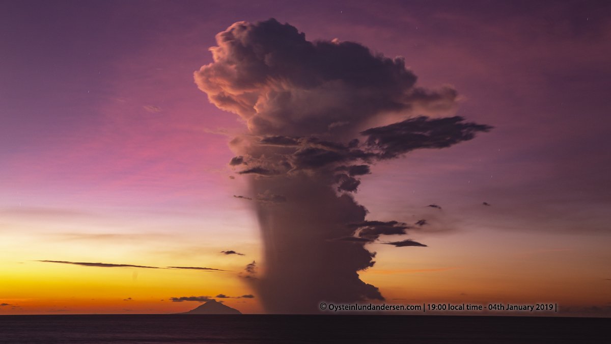
In Chile
 , the volcanic complex
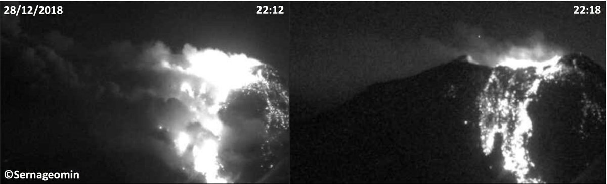
patton_cascadia on Twitter
Jason R. PattonPublished on Dec 29, 2018
Time Comparison of Sentinel-1 Imagery These are the "RGB diff" product, which is a combination of the VH, VV, and VH-VV data.
Today's image of Krakatau as the planet is in reaction. Once again.
Translated from Spanish by Microsoft
Slight ash emission#Popocatépetl - 8: 22 H. Dispersion to the side of Puebla.
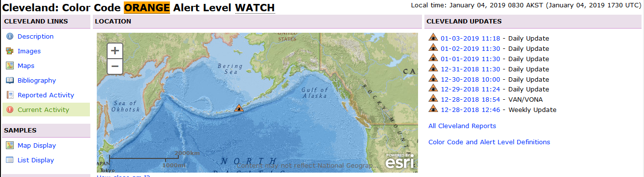
ASH3D: Ashfall Forecast for Hypothetical Eruption

Translated from Spanish by Microsoft
Slight ash emission
ASH3D: Ashfall Forecast for Hypothetical Eruption
-
This ashfall graphic is the output of a mathematical model of volcanic ash transport and deposition on the ground (Ash3D, USGS).
[*]This model shows expected ashfall accumulation (deposit thickness) for actual or hypothetical eruption
[*]AVO produces this graphic when a volcano is restless by assuming a reasonable hypothetical eruption, in order to provide a pre-eruptive forecast of areas likely to be affected. During an eruption, AVO updates the forecast with actual observations (eruption start time and duration, plume height) as they become available
[*]Colored contour lines represent points of equal ash thickness on the ground. Small accumulations of ash may occur beyond the "Trace" contour. Actual deposit thickness may vary from the forecast as the modelled points are based on our best estimates. Thickness terms are explained here
[*]This graphic does not show ash cloud movement in the atmosphere; please refer to the other graphics for ash cloud forecasts. Click here to return to other models output.
[*]Report ashfall observations here.
[*]For more information about ASH3D, see USGS Open-File Report 2013-1122.
[*]Return to Cleveland activity page for more information on its eruptive status
Intersting video explaining the Italian submarine volcanoes, incluiding the Marsili, to which has the Italians worried lately, not just them considering the circumnstances ....
--it has the option of english subtitles
--it has the option of english subtitles
_https://www.ilmamilio.it/c/comuni/12417-dall-etna said:From Etna, to Stromboli to Marsili: that monstrous volcano drowned in the middle of the Tyrrhenian Sea. That's scary
Published: Wednesday, 26 December 2018 16:11 | Written by newsroom
The awakening of the Etna system also alerts other areas. The giant that lies between the Sicilian and Calabrian coasts is capable of causing a tsunami.
ilmamilio.it
A thousand shocks in the last hours, the strongest of which - this night at 3 - has sown damage and terror throughout the province of Catania and beyond.
Etna is really scary and what happened in the past hours has really raised the level of alert.
Level that the Department of Civil Protection has already raised in the score hours for the volcano Stromboli, in the Aeolian Islands, from green to yellow noting the increase in activity of the always awake island plant probably caused by the noisy and treacherous awakening of Etna. --- it did, next post
However, there is another volcano that, potentially, is even more frightening than Etna. It is a giant, an immense monster that lies drowned in the lower Tyrrhenian Sea, between the coasts of southern Campania, Calabria and Sicily: about 80 km northwest of Stromboli, the volcano Marsili (discovered around 1920 and intolerated to the Italian eighteenth-century scientist), is considered the largest in Europe: disposed indirezione south-east, 70 km long and 30 wide, the building of the volcano is more than 3000 meters high and its top is located about 450 meters below sea level.
If the Marsili, observed special for at least 10 years especially by the CNR that has conducted many specific researches, were to wake up, they would be pain. An eventuality that the experts consider possible and indeed it seems that in the last months there have been signs in this sense.
To worry is not only a possible major eruption, but also the possibility that the building of the volcano because of an important activity can collapse with a huge displacement of matter: the possibility that the Marsili, therefore, causes a tsunami is not considered remote. On the contrary.
According to the calculations, clearly on the basis of the amount of energy developed by a possible eruption and its dynamics, experts estimate that possible anomalous waves of tidal wave can reach, after the Aeolian Islands, the coasts of Campania, but especially Calabria and Sicily.
A real danger.
Translated with www.DeepL.com/Translator
image from Volcano Webcams of the world - interactive viewer including live seismogramshttps://youmedia.fanpage.it/video/ag/XDMnc-Sw_roZJtOR said:Stromboli, volcanic activity and magnitude 3.6 shock
images of the eruption
published on 7 January 2019 at 11:28 a.m.
The eruptive activity of Stromboli, filmed by the webcam that points to the top of the volcano and diffused with these images in timelapse, is worrying. The mayor has banned excursions on the volcano, meanwhile there was also a shock of magnitude 3.6 between Stromboli and Calabria felt distinctly in Tropea and Ricadi (Vibo Valentia)
Translated with www.DeepL.com/Translator
Jan 7th
STROMBOLI. SPECIAL GUARDED. WHILE THE VOLCANO'S ACTIVITY CONTINUES WITH INCANDESCENT LAPILLI EXPLOSIONS, AT NIGHT, AT 0354, THERE WAS AN EARTHQUAKE OF MAGNITUDE 3.6 THAT AFFECTED THE LOWER TYRRHENIAN SEA BETWEEN TIRRENO TRA LO STROMBOLI AND LA CALABRIA . THE SHOCK WAS FELT IN THE PROVINCES OF CATANZARO, VIBO VALENTIA AND REGGIO DI CALABRIA. THERE IS NO DAMAGE TO PEOPLE OR PROPERTY. VIULCAN ACTIVITY REMAINS UNDER THE STRICT CONTROL OF THE NATIONAL INSTITUTE OF GEOPHYSICS AND VOLCANOLOGY OF CATANIA AND CIVIL PROTECTION.
Translated with www.DeepL.com/Translator

Translated from Indonesian by Microsoft
Hello friend, here is the geology geomin share info about the type of volcano as seen from its activities. Indonesia has 129 volcanoes A type A volcano composed as many as 79 of the fruit, the volcano type B as much as 29 fruit and type C totaled 21 pieces.
January 9, explosion of San Cristobal volcano in Nicaragua
AgainThe Watchers@TheWatchers_
Powerful eruption at Manam volcano, ash to 16.7 km (55 000 feet) a.s.l., P.N.G.
2:41 AM - Jan 8, 2019
https://watchers.news/2019/01/11/manam-eruption-january-11-2019/ said:High-level eruption at Manam volcano, ash to 15.2 km (50 000 feet) a.s.l., P.N.G.
A new high-level eruption took place at Papua New Guinea's Manam volcano at around 04:25 UTC on January 11, 2019. The Aviation Color Code is Red.
According to the Darwin VAAC, the eruption produced a column of ash rising up to 15.2 km (50 000 feet) above sea level. The volcanic ash was observed on satellite imagery and confirmed by ground reports.
Volcanic ash is hard to discern due to obscuration by meteorological cloud, the center said 06:51 UTC. Volcanic ash to 5.5 km (18 000 feet) a.s.l. is expected to dissipate within 6 hours.
The Rabaul Volcano Observatory's assistant director Ima Itikarai said the eruption on January 7th came from Manam's southern crater. "While the observatory is monitoring the eruption remotely, an eye-witness has confirmed plumes of ash and scoria, and a lava flow from the crater to the coast."
"Two villages on the south-east of the island were showered in scoria rocks of 2 cm (0.8 inches) in diameter," Itikarai said, adding that the situation on the island is volatile and there is a risk of activity intensifying.
If monitoring equipment indicated a severe eruption it would be difficult to get a timely warning to Manam, Itikarai said, as reported by Radio New Zealand.
"And that is one problem that we have experienced in the country is that we send out information to the authorities. But the challenge is for that information all going down to the affected communities and in this case Manam."
It is up to the provincial administration to ensure people on Manam had the information they need to avoid eruptions, he said.
RVO urged residents and tourists to stay away from the four main valleys where lava flow, pyroclastic flow, could be channeled into. He also warned of the potential for mudslides given the ash and scoria fall mixing with current heavy rains.
Manam has previously experienced similar mudslides which have destroyed houses.
Geological summary
The 10-km-wide (6.2 miles) island of Manam, lying 13 km (8 miles) off the northern coast of mainland Papua New Guinea, is one of the country's most active volcanoes. Four large radial valleys extend from the unvegetated summit of the conical 1 807-m-high (5 928 feet) basaltic-andesitic stratovolcano to its lower flanks.
These "avalanche valleys" channel lava flows and pyroclastic avalanches that have sometimes reached the coast. Five small satellitic centers are located near the island's shoreline on the northern, southern, and western sides.
Two summit craters are present; both are active, although most historical eruptions have originated from the southern crater, concentrating eruptive products during much of the past century into the SE valley.
Frequent historical eruptions, typically of mild-to-moderate scale, have been recorded since 1616. Occasional larger eruptions have produced pyroclastic flows and lava flows that reached flat-lying coastal areas and entered the sea, sometimes impacting populated areas. (GVP)
12 January, eruption of Ibu Volcano in Halmahera West Maluku, Indonesia
[/embed]
[/embed]
_https://www.youtube.com/watch?v=5Z2ukssMQYY said:Tempo.co, Jakarta - Gunung Ibu in West Halmahera, North Maluku, erupted at 17.12 WIT, Saturday, January 12, 2019. Observation post of the Volcanology and Geological Disaster Mitigation Center (PVMBG) Gunung Ibu said that the eruption was about 800 meters from the crater peak.
"The volcanic ash column is leaning to the south," said Head of the Center for Information and Public Relations of the National Disaster Management Agency (BNPB) Sutopo Purwo Nugroho in a written statement received by Tempo, Saturday, January 12, 2019.
According to Sutopo, the community is still encouraged not to carry out activities within a 2 kilometer radius from the top of the crater. In addition, he said, there was a sectoral expansion of 3.5 kilometers to the opening of the crater in the northern part of the active crater of Gunung Ibu.
Although it erupted, Sutopo said that Gunung Ibu was still on level 2 alert status. The community did not need to evacuate because the coverage was still outside the dangerous zone. "People have understood this eruption and did not panic, because almost every day an eruption occurs," he said.
Sutopo explained that since the last three months of Mount Ibu almost every day there was an eruption. In fact, he said, there were 80 eruptions, 18 avalanches, and 64 gusts at Mount Ibu which were recorded on 10 January. "The name is active volcanoes even though alert status can erupt at any time. What is important is that the community is in a safe zone," he said.
Sutopo said that currently PVMBG continues to monitor the volcanic activity. The community is asked to always comply with the PVMBG recommendations because this official institution has the authority to monitor and provide early warnings regarding volcanic activity in Indonesia.
[B]Øystein Lund Andersen[/B] @[B]OysteinLAnderse[/B]
The volume of the lava-dome of#Merapi volcano (Central-Java) is now 308.000m3, with a growth rate if 2600m3/day - as of 21th November. Foto/Info:@BPPTKG
January 7th
January 12th
https://twitter.com/BPPTKG/status/1084101353083949057 said:
A powerful eruption of the Shiveluch volcano ( ) in Kamchatka
Experts have recorded very high activity on the northernmost active volcano of the peninsula. The Shiveluch volcano in Kamchatka may begin erupting at any time. According to volcanologists, signs of activity appeared after the earthquake at the end of December last year, and now almost every day there is a release of ash and a hot avalanche. A similar situation was observed before the eruption of Shivelucha in 2010. According to TASS, the probability of a recurrence of an emergency is very high.
- Even small emissions are accompanied by hot streams of volcanic mixture, from which it is impossible to escape. Sometimes the speed can reach up to 200 kilometers per hour," experts remind us of the danger.
Translated with www.DeepL.com/Translator
13 January, explosions of Anak Krakatau volcano
https://www.volcanodiscovery.com/es/krakatau.html said:Caldera 813 m (2,667 ft.) / Anak Krakatau: 189 m
Sunda Strait, Indonesia, -6.1°S / 105.42°E
Current status: erupción (4 out of 5)
Last update: 13 ene 2019 (currently relatively calm, intermittent phreatomagmatic explosions from crater lake)
_https://www.efe.com/efe/america/sociedad/el-volcan-de-fuego-guatemala-eleva-una-columna-ceniza-a-4-300-metros/20000013-3865752 said:Guatemala's Volcán de Fuego raises a column of ash to 4,300 meters
The Volcan de Fuego in Guatemala presented today an activity within the average parameter, showing a column of ash that rises to 4,300 meters above sea level and weak and moderate explosions in a pattern of 8 to 15 per hour.
Julio Sanchez, spokesman for the National Coordinator for Disaster Reduction, indicated that the ash from the volcano, located in the departments of Sacatepéquez (center), Escuintla (south) and Chimaltenango (west) is heading west and southwest of the crater.
Translated with www.DeepL.com/Translator
Italy: Plumes of ash rise above ski resort as Mount Etna roars back into action
Trending content
-

-

-
Thread 'Coronavirus Pandemic: Apocalypse Now! Or exaggerated scare story?'
- wanderingthomas
Replies: 30K