In the video there is a short moment with a flash, marked in the screen shot below with an arrow. Is that just hot gas momentarily visible as the rest is covered in dust, or is it some kind of internal lightening?Mexican authorities issued a ‘level 2’ yellow alert.
9 Jan, 2020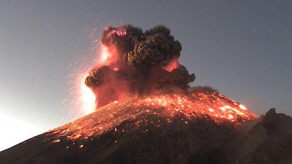
WATCH: Mexico issues yellow alert after Popocatepetl volcano erupts spectacularly
One of Mexico’s most active volcanoes, Popocatepetl, erupted on Thursday morning, spewing ash high into the air above and showering lava around its crater. Officials have issued a yellow alert in response to the volcanic activity.www.rt.com
You are using an out of date browser. It may not display this or other websites correctly.
You should upgrade or use an alternative browser.
You should upgrade or use an alternative browser.
Volcanoes Erupting All Over
- Thread starter Laura
- Start date
Philippines
Alert level raised in the Philippines as Taal Volcano erupts, prompts evacuations
Snip:
 www.rt.com
Alert level raised in the Philippines as Taal Volcano erupts, prompts evacuations
Snip:
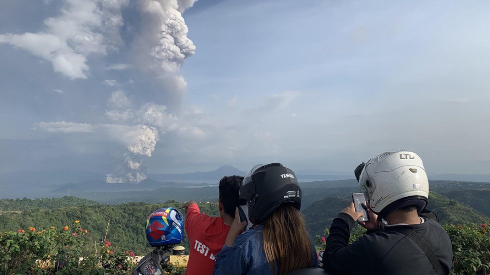
The Taal Volcano in the central Philippines rumbled to life on Sunday, spewing ash and prompting evacuations in nearby communities. The volcano is located on the island of Luzon and is the country's second most active volcano.
The Philippine Institute of Volcanology and Seismology (PHIVOLCS) raised the status of the Taal Volcano from Alert Level 1 to Alert Level 2 at 2:30 p.m. Sunday, local time, indicating a moderate level of volcanic unrest. This was upgraded less than two hours later to an Alert Level 3, indicating a high level of volcanic unrest. The alert system has five levels with Alert Level 5 meaning a hazardous eruption is in progress.
"Taal Volcano Main Crater has escalated its eruptive activity, generating an eruption plume 1 km [3,280 feet] high accompanied by volcanic tremor and felt earthquakes in Volcano Island and barangays of Agoncillo, Batanga. Ashfall is currently being showered on the southwest sector of Taal," PHIVOLCS said in a statement.
"Magma is intruding from below. If eventually this will continue to move up, then there can be a magmatic eruption which is more dangerous," Renato Soldium, PHIVOLCS officer-in-charge, told CNN Philippines.
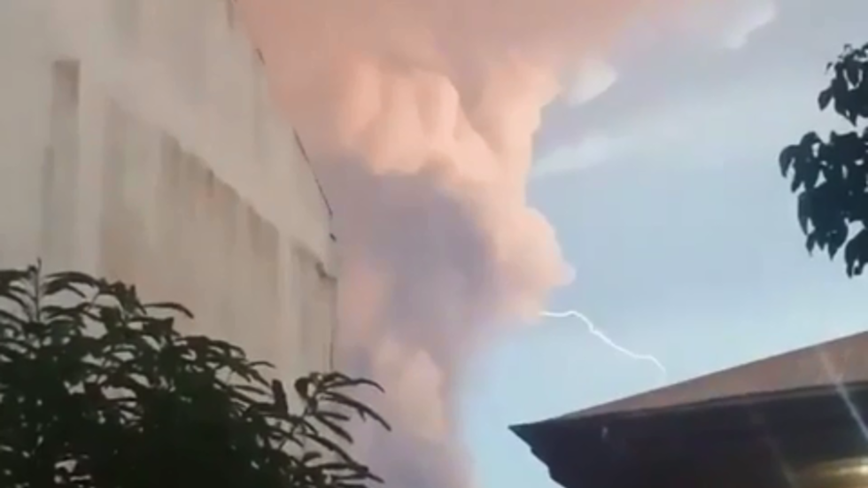
WATCH lightning strike over Taal Volcano in the Philippines during 1st eruption in DECADES
The Philippines' Taal volcano has erupted, spewing a large column of ash which prompted raised alert levels and the evacuation of nearby communities. Making the sight even more menacing, lightning was seen hitting the ash plume.
WATCH lightning strike over Taal Volcano in the Philippines during 1st eruption in DECADES has a contains a Tweet showing more lightening from the Taal volcano.

In the above volcano there is plenty of water that during this eruption evaporates and rises rapidly in a warm humid air mass. About Volcanic lightning - Wikipedia has:
The spike in the mountain's activities prompted the Philippine Institute of Volcanology and Seismology (PHIVOLCS) to upgrade its threat level twice within an hour. The alert level skyrocketed from 'abnormal' to 'magmatic unrest,' suggesting that the volcano might even spew some lava.
The complex volcano rises from the waters of its namesake lake, featuring a number of craters. Its largest crater has a small lake of its own.
In the above volcano there is plenty of water that during this eruption evaporates and rises rapidly in a warm humid air mass. About Volcanic lightning - Wikipedia has:
Volcanic lightning
is an electrical discharge caused by a volcanic eruption, rather than from an ordinary thunderstorm. Volcanic lightning arises from colliding, fragmenting particles of volcanic ash (and sometimes ice),[1][2] which generate static electricity within the volcanic plume.[3] Volcanic eruptions have been referred to as dirty thunderstorms[4][5] due to moist convection and ice formation that drive the eruption plume dynamics[6][7] and can trigger volcanic lightning.[8][9] But unlike ordinary thunderstorms, volcanic lightning can also occur before any ice crystals have formed in the ash cloud.[10][11]
The earliest recorded observations of volcanic lightning[12] are from Pliny the Younger, describing the eruption of Mount Vesuvius in 79 AD, "There was a most intense darkness rendered more appalling by the fitful gleam of torches at intervals obscured by the transient blaze of lightning."[13] The first studies of volcanic lightning were also conducted at Mount Vesuvius by Professor Palmieri who observed the eruptions of 1858, 1861, 1868, and 1872 from the Vesuvius Observatory. These eruptions often included lightning activity.[13]
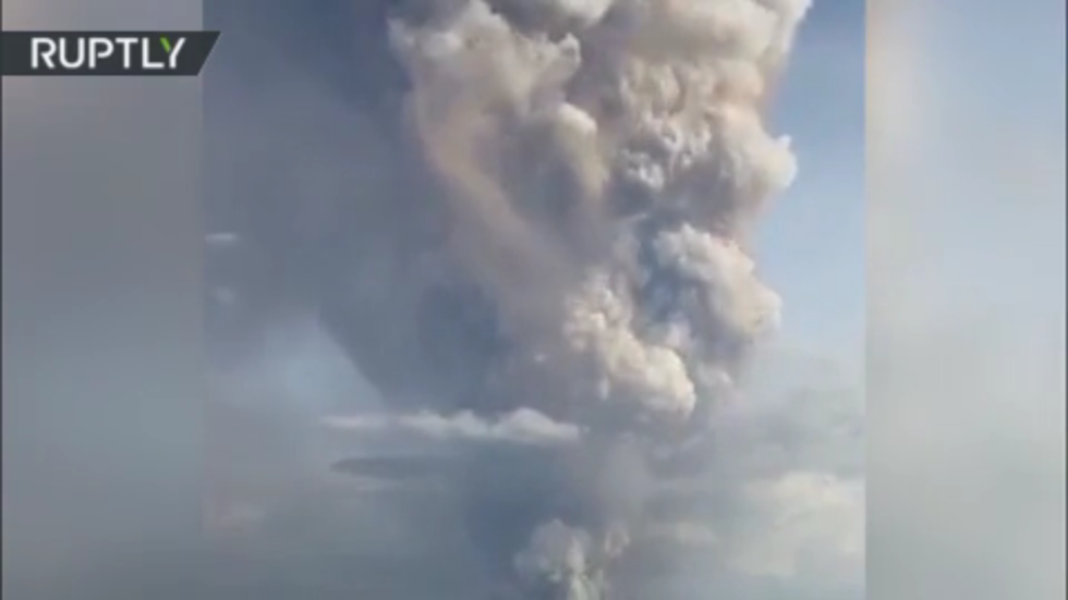
Philippine Institute of Volcanology & Seismology raises Taal Volcano alert level to ‘hazardous eruption imminent’
The Philippines’ Taal Volcano has received the fourth out of five alert levels, now standing at ‘hazardous eruption imminent’. The Taal has emitted a massive column of steam and ash, prompting evacuation of nearby settlements.
Below is an edited screen shot of a map of the area. The Taal volcano is the red spot south of Manila.The Philippine Institute of Volcanology and Seismology (PHIVOLCS) has revised the alert level of the volcano several times through the day, and currently it stands at level four – out of five possible – ‘hazardous eruption imminent’. The institute said two volcanic earthquakes have been registered, while volcanic tremor persisted since 0300 am GMT.
Earlier, Manila international airport has suspended flights over the eruption of the Taal volcano, located some 55 km to the south.
"Flight operations at the Ninoy Aquino International Airport have been temporarily suspended due to the volcanic ash from the eruption of Taal Volcano," the Manila International Airport Authority stated.
New eruption of La Cumbre volcano in Galapagos
https://watchers.news/2020/01/13/new-eruption-at-fernandina-cerro-la-cumbre-volcano-lava-flows-descending-to-the-coast-galapagos-ecuador/ said:A new eruption started at Fernandina volcano (Cerro La Cumbre), Galapagos, Ecuador on January 12, 2020. The last eruption of this volcano took place from June 16 to 18, 2018. The island has no human population.
The eruptive activity started between 23:00 and 23:10 UTC on January 12, according to the IGEPN (Ecuador's Geophysical Institute).
Seismicity under the volcano started increasing at 20:42 UTC with M4.7, followed by 29 localized events with magnitudes below 3.1. At this time, the Taal volcano in the Philippines was already in a major eruption.
The first images show a radial fissure along the southeast edge of the volcano, with lava flows descending to the coast.
Fernandina is one of the youngest islands in the archipelago. Its ecological value is very high because its ecosystems host unique species such as terrestrial and marine iguanas, snakes, endemic rats, non-flying cormorants, and penguins, among others.
...
https://watchers.news/2020/01/11/eruption-at-kuchinoerabujima-volcano-japan/ said:Japan's Kuchinoerabujima volcano erupted at 06:05 UTC on January 11, 2020, ejecting volcanic material up to 300 m (984 feet) from the crater of Mount Shindake. This is the first eruption at the volcano since February 2, 2019. Kuchinoerabujima is a volcano island in Satsunan Islands, Japan, about 120 km (75 miles) SSW of Kagoshima city and about 1 100 km (685 miles) WSW of Tokyo. A series of eruptions with pyroclastic flows were recorded in December 2018 and January 2019.
Volcanic ash cloud reached up to 2.7 km (9000 feet) above sea level.
There were no pyroclastic flows produced and no evacuation orders were issued, the Japan Meteorological Agency (JMA) said.
The Philippine volcano that erupted Sunday is one of few volcanoes that is being watched closely in general:
 www.rt.com

Philippines’ Taal Volcano belches LAVA, as locals brace for ‘hazardous eruption’ & ‘volcanic tsunami’ (PHOTOS, VIDEOS)
Taal Volcano in the Philippines has coated its surroundings with ash, shutting down businesses and public places. An alert warning that a ‘hazardous eruption’ is ‘imminent’ remains in place.
About Decade Volcanoes - WikipediaThe Taal might not look very imposing – it’s one of the world’s smallest volcanoes – but it is one of the so-called Decade Volcanoes. There are only 16 such volcanoes around the globe boasting such a designation, meaning they are known for violent and deadly eruptions and are therefore worthy of close monitoring and study. The last major eruption of the Taal Volcano occurred in 1977, while the deadliest one recorded happened in 1911, killing over 1,300 people and destroying all the settlements on the island.
The Decade Volcanoes are 16 volcanoes identified by the International Association of Volcanology and Chemistry of the Earth's Interior (IAVCEI) as being worthy of particular study in light of their history of large, destructive eruptions and proximity to populated areas. The Decade Volcanoes project encourages studies and public-awareness activities at these volcanoes, with the aim of achieving a better understanding of the volcanoes and the dangers they present, and thus being able to reduce the severity of natural disasters.
They are named Decade Volcanoes because the project was initiated in the 1990s as part of the United Nations-sponsored International Decade for Natural Disaster Reduction.
A volcano may be designated a Decade Volcano if it exhibits more than one volcanic hazard (people living near the Decade Volcanoes may experience tephra fall, pyroclastic flows, lava flows, lahars, volcanic edifice instability and lava dome collapse); shows recent geological activity; is located in a populated area (eruptions at any of the Decade Volcanoes may threaten tens or hundreds of thousands of people, and therefore mitigating eruption hazards at these volcanoes is crucial); is politically and physically accessible for study; and there is local support for the work.
https://www.phivolcs.dost.gov.ph/index.php/taal-volcano-bulletin-menu/9637-eruption-update-for-taal-volcano-alert-level-4-hazardous-eruption-imminent-14-january-2020-01-00-pm said:ERUPTION UPDATE FOR TAAL VOLCANO ALERT LEVEL 4 (HAZARDOUS ERUPTION IMMINENT) 14 JANUARY 2020 01:00 PM
Taal Volcano’s eruption has been characterized by continuous magmatic and hydrovolcanic activity. Lava fountains generated 800-meter tall dark gray steam-laden plumes that drifted to the general southwest.
New fissures or cracks were observed in Sinisian, Mahabang Dahilig, Dayapan, Palanas, Sangalang, Poblacion, Lemery; Pansipit, Agoncillo; Poblacion 1, Poblacion 2, Poblacion 3, Poblacion 5, Talisay and Poblacion, San Nicolas. A fissure was also documented across the road connecting Agoncillo to Laurel, Batangas.
The Philippine Seismic Network recorded a total of forty-nine (49) volcanic earthquakes in the Taal region from 2:00 AM to 10:00 AM today. Seven (7) of these earthquakes were felt with intensities ranging from Intensity II to IV in Tagaytay City. The intense seismic activity coupled with fissuring on the caldera region likely signifies continuous magma intrusion beneath the Taal edifice, which may lead to further eruptive activity.
Alert Level 4 still remains in effect over Taal Volcano. This means that hazardous explosive eruption is possible within hours to days. DOST-PHIVOLCS strongly reiterates total evacuation of Taal Volcano Island and areas at high risk to pyroclastic density currents and volcanic tsunami within a 14-kilometer radius from Taal Main Crater. Areas around Taal Volcano are advised to guard against the effects of heavy and prolonged ashfall. Civil aviation authorities must advise the aviation industry to avoid the airspace around Taal Volcano as airborne ash and ballistic fragments from the eruption column pose hazards to aircraft. DOST-PHIVOLCS is continually monitoring the eruption and will update all stakeholders of further developments.
Evacuations are in curse, they are frantic to getting people out of the danger zone.
https://www.manilatimes.net/2020/01/16/second-headline/govt-struggles-vs-defiant-evacuees/674959/ said:...
‘Pyroclastic surge’
Meanwhile, experts warned that a possible “base surges” of ash that contain hot gases and rock fragments that Taal Volcano might throw out if hazardous eruption occurred could right away destroy areas near the island.
Taal Volcano Observatory Officer in Charge Paolo Reniva said the threats from the pyroclastic density currents could emerge over the volcano’s 14-kilometer radius from the main crater.
“Ang base surges po ‘yung pyroclastic flow na tatawid ng Taal Lake… Ito ay posibleng mangyari kapag itinaas na natin sa Alert Level 5 ang status ng Taal (The pyroclastic surge will cross Taal Lake. This is possible if we raise alert status to 5 over Taal),” Reniva told GMA’s “Unang Balita” program.
He said they would traverse around 7 to 10 kilometers from the volcano down to the nearby communities at a speed of “80 kilometers per hour.”
Reniva added that the base surges could generate volcanic tsunamis that will swamp the lake’s shorelines.
These base surges “can sandblast everything in their path, including the lake shore on the other side,” according to expert Beth Bartel from Unavco, a non-profit university-governed consortium that facilitates geoscience research.
To understand what this unpredictable “hazardous eruption” might bring to us, experts said these possible surges if Taal would burst anytime soon could damage agriculture, infrastructure, cut communications, damage property, pollute water supplies, and worse, kill off people and animals near the island.
In its 5 p.m. bulletin, Phivolcs said Taal Volcano’s activity was characterized by continuous but generally weaker eruption of the main crater.
New fissures were observed in Sambal Ibaba, Lemery.
Dried-up up of portions of Pansipit River were also seen, Phivolcs said.
The main crater lake was drained and new vent craters were formed inside the main crater and on the north flank of the volcano, it added.
Do someone knows where to translate from philipino? google nor deepl do.
I typed ,translate Tagalog to English in Google, and copy pasted some text, and that worked.Do someone knows where to translate from philipino? google nor deepl do.
Text,
Ang BASE SURGE ay panganib ng pagsabog ng Bulkang Taal, ito ay ang mabilis na daloy ng mga pinaghalong pira-pirasong bato at abo na may kahalong mainit at umaasong singaw (steam).
Translation,
BASE SURGE is a danger of erupting from the Tall Volcano, it is the rapid flow of fragments of rock and ash mixed with hot and rising steam (steam).
#IGAlInstant Information VOLCANO SANGAY No. 005
MONDAY, 20 JANUARY 2020
Images provided by the ECU 911 show the glowing block bearing on the south-eastern flank of the volcano and the emission of gas and variable ash content.
using deepl
---
---
MONDAY, 20 JANUARY 2020
Images provided by the ECU 911 show the glowing block bearing on the south-eastern flank of the volcano and the emission of gas and variable ash content.
using deepl
---
---
https://watchers.news/2020/02/13/thermal-emission-at-ol-doinyo-lengai-suggests-eruption-of-natrocarbonatite-lava-tanzania/ said:Thermal signature at Ol Doinyo Lengai suggests eruption of natrocarbonatite lava, Tanzania

Satellite imagery taken by the Copernicus Sentinel-2 satellite on February 3, 2020, showed a moderate thermal signature at Tanzania's Ol Doinyo Lengai volcano, indicating that natrocarbonatite lava erupted a few days ago.
This is the only volcano in the world that erupts natrocarbonatite lava-- highly fluid lava that contains almost no silicon.
As shown by Sentinel-2 satellite imagery, the crater of the volcano had moderate thermal signature which suggests that carbonatite lava was emitted a few days ago, Culture Volcan reports.
The current eruptive period of this volcano, which is also called the Mountain of God by the Maasai people, started on April 9, 2017
...
Natrocarbonatite lava is much cooler than other lavas, being only about 510 °C (950 °F) compared to temperatures over 1 100 °C (2000 °F) for basaltic lavas.
Natrocarbonatite is the most fluid lava in the world. Lava with a low gas content can flow like a whitewater stream, and actually has a viscosity near that of water. This lava glows orange at night, but is not nearly as bright as silicon-based lavas since it is not as hot.
Indonesia volcano Mount Merapi erupts, sending 16,000-foot plume of ash into the air.

Indonesia volcano erupts 16,000-foot plume of ash
Mount Merapi, Indonesia's most active volcano, erupted a column of ash about 16,000 feet into the air on Friday.thehill.com
Mount Merapi, Indonesia's most active volcano, erupted a column of ash about 16,000 feet into the air on Friday.
According to Agence France-Presse, there are no reports of damage and officials are encouraging those who live nearby not to panic.
The volcano, which is near the historic city of Yogyakarta, had another big eruption earlier this month, which sent even more ash into the air at 20,000 feet. That eruption covered the nearby city of Solo with ash and forced an airport closure.
#EXCLUSIVE : In #Indonesia, the volcano Merapi threw a 5-kilometer column of ash. pic.twitter.com/ML9FVY3ZOo
— Sushmit Patil Сушмит Патил सुश्मित पाटिल (@PatilSushmit) March 27, 2020
Authorities did not raise the alert level for Merapi, which had its last major eruption in 2010, killing 300 people and forcing 280,000 to evacuate.
The volcano has a history of deadly eruptions, including one in 1930 that killed around 1,300 people and one in 1994 that left around 60 dead.
Indonesia is made up of a series of islands with over 120 active volcanoes.
The latest eruption comes as the country, like others across the globe, is battling the coronavirus. Indonesia's cases topped 1,000 on Friday in its biggest daily jump of diagnoses yet.
https://watchers.news/2020/03/31/increased-activity-at-stromboli-volcano-lava-reaches-the-coastline-italy/ said:Increased activity at Stromboli volcano, lava reaches the coastline, Italy
Activity at Stromboli volcano increased from medium to high levels on March 28 into 29, 2020, followed by lava overflow first observed around 23:40 UTC on March 30, 2020.
Lava reached the coastline at around 01:40 UTC on March 31, INGV Osservatorio Etneo reported today, adding that this phenomenology is accompanied by seismic signals that can be associated with landsliding and rolling of incandescent rocks along the Sciara del Fuoco.
The activity increased from medium to high levels on March 28 into 29, one day after the volcano produced a large, almost-perfect smoke ring.
"The volcanic activity was characterized by scoria-rich explosions mainly located at NE crater, reaching very high infrasonic pressure (3.6 bar) and accompanied by overflows from the NE crater rim during the last night (between 17:00 and 23:00 UTC)," Labaratorio Geofisica Sperimentale (LGS) reported on March 29, referring to activity at the volcano in 24-hours to 08:34 UTC on March 29.

...
Trending content
-

-

-
Thread 'Coronavirus Pandemic: Apocalypse Now! Or exaggerated scare story?'
- wanderingthomas
Replies: 30K -
