Watch the skies and land and oceans

I don't know if this is a sign from the Cosmos or not but the solar references are obvious.

22 riders stuck on Knott’s Berry Farm thrill ride for 2 hours​


The Sol Spin ride that looks like a flying blender strands riders six stories in the air when it suddenly stops working.​

Sol Spin replaced Windseeker, a short-lived 301-foot-tall tower ride that the park removed after a series of malfunctions on the Mondial rides stranded visitors hundreds of feet in the air for hours during the summer of 2012.

1732017139212.png
 
Snow hit USA.

1732055278865.png
U.S. Snow Spreading East; Rescue In Morocco; UK Snow Builds, Farmers Protest Regardless; Mountain Snowpack Above Average; + Study: Antarctic Sea Ice Has Increased Since 1979

U.S. Snow Spreading East​


The storms currently dropping feet of snow on the higher reaches of the Western U.S. are shifting east, preparing to hit North Dakota late Monday with heavy snowfall, powerful winds, and a sharp drop in temperatures.

Snowfall of 8 inches is expected in north-central areas, with higher totals likely in the Turtle Mountains.

A Winter Storm Watch is in effect Monday morning through to Tuesday evening for counties including Bottineau, Rollette, and Ramsey. Travel conditions will deteriorate quickly due to slippery roads, blowing snow, and poor visibility.

In the Bismarck-Mandan area, rain will have turned to snow by Tuesday morning, and fierce northwest winds will create additional hazards as snow lingers Tuesday night. Daily highs will be in the 20s with lows tanking to the teens through the week.


Floods of the day:
 
A “once-in-a-decade” bomb cyclone sweeps across the northwestern U.S. and parts of Canada early Wednesday. The first death has already been reported, and hundreds of thousands of people are without power in Washington, California and British Columbia.

US north-west endures ‘bomb cyclone’ as east coast faces persistent wildfires

Coasts facing extreme weather conditions, as atmospheric river is expected to extend from Hawaii to California​

Millions of people on both US coasts are enduring extreme weather conditions, with a lethal, once-a-decade bomb cyclone storm system descending on the north-west while east coast residents are experiencing persistent wildfires amid weeks of bone-dry drought conditions. A woman was killed near Seattle when a tree fell on her home, CNN reported. Wind gusts between 72 and 77mph have been reported, and more than 650,000 people were waking up on Wednesday without power in Washington state. An additional 150,000 people are without power in British Columbia as well as 24,000 in northern California.
The storm is expected to unleash snow, with blizzard and avalanche warnings in the mountains, and hurricane force winds over the region. The intensity of the storm out west, measured by its minimum central air pressure, was consistent with a category 4 hurricane, the Washington Post reported. Conditions known as an atmospheric river are also expected to extend from Hawaii to California and the storm is expected to dump 10 to 20 in of rain on California’s northern Coast Ranges mountainous area.

The fire department in Bellevue, Washington, urged people to stay inside on the lowest floor of their homes and away from windows. An Amtrak train was also involved in a collision outside of Seattle and CNN obtained videos of downed trees on power lines.

On the east coast, New York City is under its first drought warning in more than 20 years. New York City’s reservoirs are currently around 60% capacity, but are usually above 79% capacity at this time of year, Rohit Aggarwala, the commissioner of the city’s department of environmental protection, told NBC News. Over the last 10 weeks, the city has had 8.23in less rain than is typical for the period.
The New York City area is expected to see some rain beginning on Wednesday night through Friday that could total up to 3in. Experts say that won’t be enough to overcome the severe drought, but hope it could slow the fires.
“We hope it will be enough to wet dry leaves and pine needles that fuel these fires,” Bill Goodman, a meterologist for the National Weather Service told the New York Times. “But we’ll just have to see what happens, and take it one storm at a time.”
1732128111132.png
Here is an image from CNN.

 
Some photos of the result of the "bomb":

Overnight snowfall in Northern California​

snowfall in Northern California, Lassen


snowfall in Northern California, Lassen


It's just the beginning of winter and it start strong.


The Met Office, the UK's meteorological agency, has placed certain regions of Scotland under an orange alert for snow and ice until 17:00 GMT. The warning reads: ‘with the risk of rural communities being cut off from the rest of the world’.

A very unsettled afternoon to come as #StormBert brings heavy rain, snow and strong winds to many parts of the UK ⚠️

In France a lot of blackout too:
Some 47,000 homes remained without power in northern France on Saturday, two days after the country was battered by Storm Caetano.


Bert monster is over west Europe:

2024 Bert storm over Europe


France: ‘Everything's rotten‘: market gardeners’ harvests ruined by bad weather in the Var region​

(Var region is the South of France enjoying a a warm climate).
1732875906904.jpeg

Often faced with heavy rain throughout November, market gardeners in the eastern Var are taking stock of their harvests, which were largely ravaged by the recent floods.

The year 2024 is proving to be a trying one for farmers. While a number of French producers, particularly of wheat and potatoes, are suffering the consequences of the heavy rain that marked the first half of the year, the market gardeners of the eastern Var region have also had some bad news.

"There's nothing left"​


This is the case for the ‘Domaine Joffrey’, located in Roquebrune-sur-Argens (Var). This 1.5 hectare market garden has only been able to harvest half its olives and vegetables. The rest was rendered unfit for consumption because of the heavy rain that recently hit the region, submerging the land.

‘There's absolutely nothing left. As you can see, everything is rotten. There's nothing more we can do. It's a shame because we could still have an interesting back-season for our local customers. Now there's nothing left,’ Nadine Joffrey, a market gardener, bitterly explained to BFM Nice Côte d'Azur as she surveyed the damage.

The next planting of aubergines and peppers will have to wait until 2025.

 
Always interesting to listen Dr. Tamitha Skov who explain how the predictions of the impact of our star are calculated.

I noticed this:
STEREO can't see everything on the sun's far side.
In fact STEREO mean two satellites (so the name of the project) and so Tamitha explain they don't cover all the Sun surface.
On a side note, looking at the the Wikipedia page we can learn that contact with STEREO-B was lost for 4 years (2014-2018) and so we where half blind for this period.

An another interesting point she explained, is the high energy which a radiation storm can have despite being not intense:
Now, back late on the 21st, region 3889 fires off a very large X-class flare.
You can see it boom right there and it launches a huge solar storm.
In fact, it also launches a radiation storm.
You can actually see some of the blizzard in the EUVI data here.
But what made it so remarkable is that back here at Earth, we did get hit by that radiation storm.
And it wasn't that it had huge fluxes.
It wasn't a super intense radiation storm, but it did have some of the highest energies
of a radiation storm that we've seen possibly since the Halloween events.
This little yellow line that you see right here, this line is half a giga electron volt.
This is like cosmic ray energies.
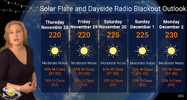
The overall prediction for coming days is:
"Even if the aurora shows are underwhelming, there are many more storm producers on the Sun right now that could send more storms our way. Amateur radio operators and GPS should expect noise levels to continue rising on the dayside radio bands and a heightened risk of big R2-R3 level radio blackouts on the dayside over the next two weeks, thanks to some big returning regions and some new flare players rotating into Earth view. The risk for radiation storms will also begin rising again as we move into the first week of December."

So the 65/70% prediction of M-Class X-flare coming:
1732917085108.png


Attachments

  • 1732917054048.png
    1732917054048.png
    1.1 MB · Views: 2
Back
Top Bottom