You are using an out of date browser. It may not display this or other websites correctly.
You should upgrade or use an alternative browser.
You should upgrade or use an alternative browser.
What's the weather where you are?
- Thread starter Maia
- Start date
Debra Lynn
Jedi
Here in the Pacific NW the temps have been going up and down by as much as 30 degrees in a single week. I've been having to use the heater and then the fan in the space of a few days. It is supposed to even out later this week though. I've been hearing that we might also have a bad fire season like last year. During the worse of the smoke we had to stay indoors and keep the windows covered.
XPan
The Living Force
As promised a couple photos from the rain & hail event in Stockholm Snösätra / Rågsved, Saturday, 12 Jun 2021 - which locally appeared to have it's peak over the area where I live (including subway station Högdalen) - while other (weather) stations received much less rain. Still... 1" isn't really that much, even if it came down within 15-20 minutes...
View attachment 46132View attachment 46134
Subway station Högdalen station is still closed; lots of people and emergency vehicles ....
Analysis of rare rain Event
Remember when I wrote about a "sinkhole" / flooding event at the subway station of Stockholm - Högdalen (south of Stockholm) last Saturday 12 June 2021 ? Located from my balcony only 0.8 km (0.5 miles) away... While the official meteorological weather observation network grid in no way captured this event, thus registering a mere 12 mm rain (0.47 inch) at the 7 km (4.4 miles) distant Tullinge station. And no other station data reported more. (I do not have full access to all weather info that is registered, I may add)
82 mm (3.22') rain within 20 minutes !
Accidentally I just bumped into a mainstream article at (DN.se) an hour ago - which wrote about some people got their basements / ground floors flooded - in this very area. A relatively close neighborhood called Gubbängen, around 3 km from my place and 2.5 km from Högdalen, got a lot more: 48.5 mm (1.89 inch) - but Högdalen was pretty extreme with 81.9 mm (3.23 inch) of rain within 20 minutes.
That a switch !
Far off form the officially reported 12 mm precipitation...
"2 meter deep water"
82 mm / 3.23 inch in 20 minutes, does explain why there was problems at the next subway station. Högdalen is an area which lies lower than it's surrounding. It is a valley. According to one of the staff members selling tickets - the water stood "2 meter" deep
 DN.se media also wrote, that this was "one of the most extreme events recorded in Stockholm" (and did not miss the opportunity to kick off another fear mongering climate-change article on top...
 )
)Torrential Rain events in the past (in Stockholm)
I have experienced 2 events with torrential rain over Stockholm during the 90s (Summer 1992 + Aug 1994) and I am sure there are a couple more event candidates, I am not aware of, or haven't written down nor tried to analyze.
Anyway - the events from 1992+94 both dumped 80-100 mm (3.1-3.9 inch) rain within a short time. I lived right next to the spherical Globen Area - at Nynäsvägen Highway - where the local street goes below the highway - and got flooded because of the silly low lying area at the street crossing - with the water standing 25-50 cm deep. Both times I went out (afterwards), to document it; and one time I went into the water, in order to help a car that got stuck. My new leather shoes - oh well - they went down the drain of course. The people never thanked for the help, which was a bit weird. In the photo below, after the car event, the water had already started to recede. (It's a longtime exposure photo).
Rare - yet it does happen sometimes
So. 80-100 mm rain events over Stockholm are pretty rare - but they do happen from time to time - and yes, they can and do create problems of course.
The most extreme rain event ever (in Sweden)
was a highly unusual one: Creating a "cataclysm" and reshaping the local mountain area and forest. The so called
The SMHI Meteorological Institute, analyzed this event deeply, the local country government of Dalarna even sells book about it - which I bought - to read in detail the local witnesses who told their stories how the extreme weather unfolded, plus all the analysis that was done in the area later. Altogether revealing that an unparalleled event had taken place. (It took a while for people to realize that, because it happened in an area where not many people live) We never thought that such an extreme event could happen in our nordic climate. Albeit I have to add, that our weather station grid in Sweden doesn't really capture large events very well - compared to the 10x denser synoptic weather station grid over Central Europe.
Now I have gone far off that 'little' Högdalen event from last weekend. I hope I didn't bore you with too many details. To be honest, I absolutely love weather in so many ways, always attentive and with my head looking into the sky, observing. Getting excited. And sometimes, I get carried away when I write or talk about it.
Ask my husband...

Full blown summer has arrived to NRW Germany: its 34 degrees Celsius- real feel 35!!!!
It’s HOT!!!!!
Our apartment is under the roof so it’s the same temperature inside and outside.
Luckily we have a balcony so I can put out a kids pool in which I‘m currently sitting and cooling
It’s HOT!!!!!
Our apartment is under the roof so it’s the same temperature inside and outside.
Luckily we have a balcony so I can put out a kids pool in which I‘m currently sitting and cooling
XPan
The Living Force
TV Weather Drama Queens
I just picked this up, what I once mentioned was so typical of how the climate-change narrative is pushed, even though not so subtle "color code changes" - influencing the human mind towards total drama. An example: German TV - between the years of 2009, 2019, and 2020. Now, it looks as if nuclear bombs and violent solar storm flares are going off everywhere
Notice that even 20°C (in 2019) was represented with brownish red colors... That's just nuts.
(Now, I am a unsure where to put this entry into the proper thread...)

I just picked this up, what I once mentioned was so typical of how the climate-change narrative is pushed, even though not so subtle "color code changes" - influencing the human mind towards total drama. An example: German TV - between the years of 2009, 2019, and 2020. Now, it looks as if nuclear bombs and violent solar storm flares are going off everywhere

Notice that even 20°C (in 2019) was represented with brownish red colors... That's just nuts.
(Now, I am a unsure where to put this entry into the proper thread...)
We had a couple of hot days during a week of much warmer temps, then yesterday, cloudy, storm, rain, and cooled down to 17 C during the night.
I've begun keeping a weather journal: lows, highs, wind direction and speed, barometric pressure and general observations.
I've begun keeping a weather journal: lows, highs, wind direction and speed, barometric pressure and general observations.
Here locally we have a severe thunderstorm warning for this weekend, I took video this morning of the gray cloud approaching to my area, because it caught my attention; the rounded shape between the clouds and the clear horizon. I know almost nothing about weather phenomena, but I keep being impressed by the clouds in the last few months, how thick and enveloping they seem.
XPan
The Living Force
Even up here in Sweden... it is hot
Yesterday the town of Målilla, in the southeast, recorded a whopping 34.6°C (94°F) - which is the highest measured JUNE temperature since year 1947. Målilla is a funny place, because it often shows up for both very hot, as well unusual cold temperatures (records) through time.
Stockholm wasn't as hot, I think it stayed around 29°C (84.2°F) yesterday, and similar today (28.8°C / 83.8°F) Still - it is nice to experience warmth up here in the north in JUNE, because normally, as we approach Midsummers eve - that's often a switch to cool, unsteady rainy weather most years. What we call a "swedish classic".

And a really big blob is visible with thunderstorms NW-W of Stockholm (but will not affect us). I can see the outline clouds (anvil) from my place, as i walked the dog.

Yesterday the town of Målilla, in the southeast, recorded a whopping 34.6°C (94°F) - which is the highest measured JUNE temperature since year 1947. Målilla is a funny place, because it often shows up for both very hot, as well unusual cold temperatures (records) through time.
Stockholm wasn't as hot, I think it stayed around 29°C (84.2°F) yesterday, and similar today (28.8°C / 83.8°F) Still - it is nice to experience warmth up here in the north in JUNE, because normally, as we approach Midsummers eve - that's often a switch to cool, unsteady rainy weather most years. What we call a "swedish classic".
And a really big blob is visible with thunderstorms NW-W of Stockholm (but will not affect us). I can see the outline clouds (anvil) from my place, as i walked the dog.
Last edited:
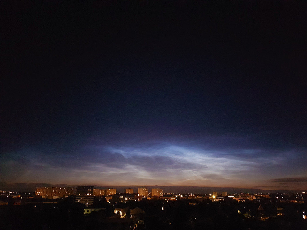
Here is the picture of a noctilucent cloud that we took from home near Paris on yesterday evening at 23h23. That's the second one we caught here, the first one was on 14th July 2009, a little earlier but at the exact same place in the sky (West/North).
Noctilucent clouds are the mark of a cooling of the upper atmospheric layers, and seeing them at such latitudes is not common. Needless to say, I admired it as it should be.
Apart from it, we have huge thunders and lighthings from several days, and they are huge!
Noctilucent clouds are the mark of a cooling of the upper atmospheric layers, and seeing them at such latitudes is not common. Needless to say, I admired it as it should be.
Apart from it, we have huge thunders and lighthings from several days, and they are huge!

In Finland, at least where I live, now it's like heatwave. Inside it's 28C, and outside it's like "cows breath", "lehmän henkäys", meaning warm or very little(if any) wind.
In daytime, there has been occasionally almost stormlike wind bursts. Sometimes even hailstorms.
Makes me feel like coconut oil, which melts at current room temperature.
In daytime, there has been occasionally almost stormlike wind bursts. Sometimes even hailstorms.
Makes me feel like coconut oil, which melts at current room temperature.
After several days of heat, this night we were hit by a storm.
The sky didn’t stop flashing with constant tunder like cargo train - so you can’t say when first lightning stopped and the second one started.
It poured rain.
It was so hot in the apartment and we couldn’t open all windows because of pouring rain and strong wind.
I haven’t slept half of the night.
it says here:

 www1.wdr.de
Sankt Augustin is like 10km from where I live.
Now it cooled down a bit; it it nice and sunny with 22 degrees right now, expected 28 in the afternoon with more overcast and expected rain in the evening.
The sky didn’t stop flashing with constant tunder like cargo train - so you can’t say when first lightning stopped and the second one started.
It poured rain.
It was so hot in the apartment and we couldn’t open all windows because of pouring rain and strong wind.
I haven’t slept half of the night.
it says here:
Wipperfürth in the Bergisches Land reported the greatest amount of rain within an hour. Between one and two o'clock in the morning, almost 50 liters per square meter fell. "The strongest gusts of wind were measured in Sankt Augustin - at 91 km / h, which corresponds to wind force 10 - and in Neuenrade in the Märkischer Kreis with 85 km / h or wind force 9.

Gewitter in NRW: Neue Woche startet ruhiger als erwartet
Nach den Gewittern vom Wochenende hatten sich viele Feuerwehren auf weitere Unwetter zum Wochenenbeginn eingestellt. Doch Blitze, Starkregen und Sturmböen blieben weitgehend aus.
Sankt Augustin is like 10km from where I live.
Now it cooled down a bit; it it nice and sunny with 22 degrees right now, expected 28 in the afternoon with more overcast and expected rain in the evening.
I haven’t slept half of the night. @Mari, it‘s been hot here in Bavaria also. Last week the temperatures rose to 35•C. The only thing that helped was a freezing cold shower. Since I’m a bit of a wuss, I started with lukewarm water on my feet, then the rest, getting colder and colder as my body parts acclimatised. Felt “right as rain” after that.
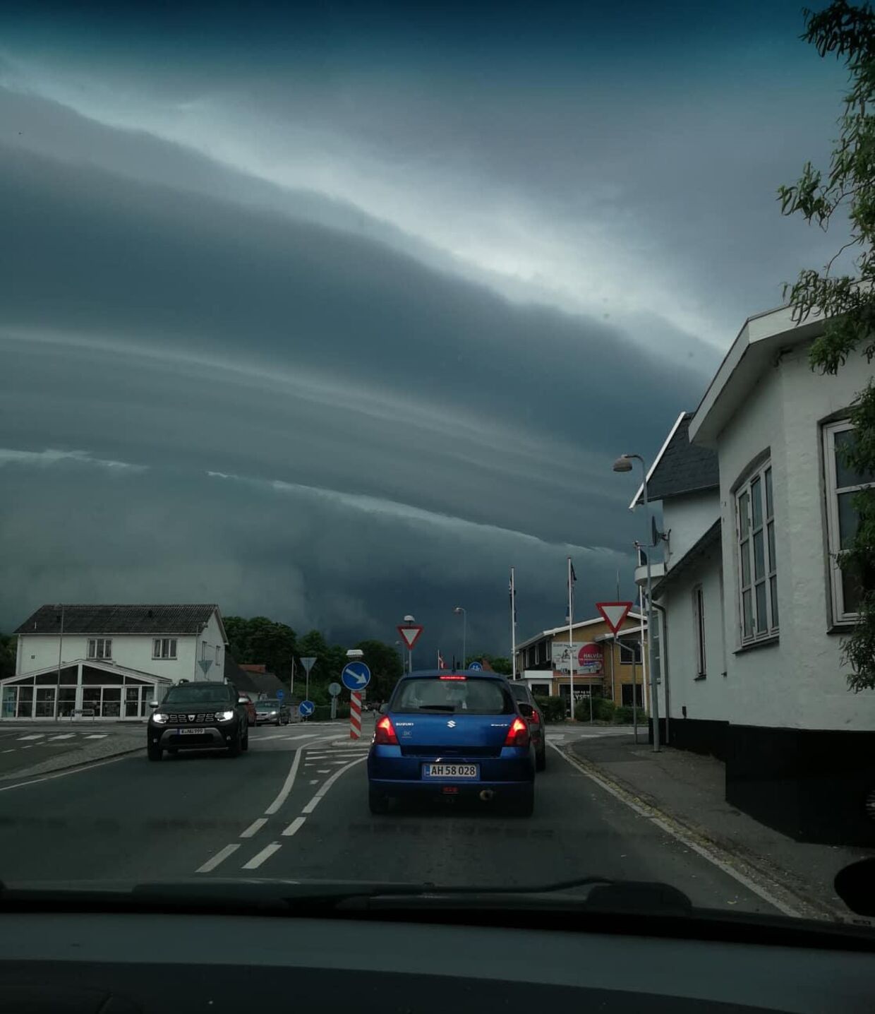
Today there were thunder and storm clouds moving in over parts of Denmark. People took a few pictures and were surprised at the dramatic cloud formations: The articles were from www.bt.dk
See the pictures of wild weather in Denmark: 'I have never seen the weather like this'


See the pictures of wild weather in Denmark: 'I have never seen the weather like this'

Attachments
XPan
The Living Force
Thunderstorms
Stockholm 21 June 2021, early morning
I don't consider T-storms to be that common over Stockholm (They are far more common and dramatic over the continent; middle and south Europe). I don't know how many times a bow-front approaches the city from the west - and then 70 km before... it either fizzles out all of the sudden - or splits in two... leaving the city out I think the location of Stockholm, being geographically on the east side of Sweden, is part of the reason, T-storms coming in from the southwest, tend to fizzle out once they reach us. Once in a while over the years, we do get exceptional events, though.
So, yesterday morning while being at the train depot Vällingby, NW of Stockholm - there was a line of thunderstorms, with frequent lightning in the distance and lovely (albeit) low rolling sounds.
I think the essence of that T-storm event were the changing colors; from blue-gray with pale distinct pinkish lightning strikes at first, then all of the sudden during sunrise, the whole landscape took a bath in yellow-orange (as the voluptuous upper parts of the big (Cb) Cumulonimbus clouds were illuminated by the rising sun) - and then, the colors went over into weird mix of blue-yellow-greenish tint.
I often notice that thunderstorms often have this strange greenish tint going on...
The thunderstorm itself wasn't anything to write home about; some strong lightning strikes made the rounds, albeit not so loud thunder. A little rain - and that was it. By the time I went home around 06:00 - the sky was all blue - not a single cloud visible.
The T-storms had moved over the sea to the NE, towards the Islands of Åland and Finland - dissolving there.


Stockholm 21 June 2021, early morning
I don't consider T-storms to be that common over Stockholm (They are far more common and dramatic over the continent; middle and south Europe). I don't know how many times a bow-front approaches the city from the west - and then 70 km before... it either fizzles out all of the sudden - or splits in two... leaving the city out
So, yesterday morning while being at the train depot Vällingby, NW of Stockholm - there was a line of thunderstorms, with frequent lightning in the distance and lovely (albeit) low rolling sounds.
I think the essence of that T-storm event were the changing colors; from blue-gray with pale distinct pinkish lightning strikes at first, then all of the sudden during sunrise, the whole landscape took a bath in yellow-orange (as the voluptuous upper parts of the big (Cb) Cumulonimbus clouds were illuminated by the rising sun) - and then, the colors went over into weird mix of blue-yellow-greenish tint.
I often notice that thunderstorms often have this strange greenish tint going on...
The thunderstorm itself wasn't anything to write home about; some strong lightning strikes made the rounds, albeit not so loud thunder. A little rain - and that was it. By the time I went home around 06:00 - the sky was all blue - not a single cloud visible.
The T-storms had moved over the sea to the NE, towards the Islands of Åland and Finland - dissolving there.
PERLOU
The Living Force

Meteo Cagnes-sur-Mer (06800) - Alpes-Maritimes : Prévisions Meteo GRATUITE à 15 jours - La Chaîne Météo
Meteo Cagnes-sur-Mer (06800) - Alpes-Maritimes ☼ Longitude : 7.15 Latitude : 43.66 Altitude : 13m ☀ Provence-Alpes-Côte d'Azur également appelée «...
Trending content
-
-
Thread 'Coronavirus Pandemic: Apocalypse Now! Or exaggerated scare story?'
- wanderingthomas
Replies: 30K -
-


