What's the weather where you are?

Complimentary • Weather Situation
Stockholm 22 June 2021

I notice that the satellite chart is showing a repeating weather situation, like that of the past days and yesterday morning: A convergence zone west of Stockholm - a line which becomes an early initiator of thunderstorms. So, you can see that line again this morning building up T-Storm cells. Hot air resides over entire East Europe, cooler air in the west - giving plenty contrast, e.g fuel for T-storms. (However, since those cells are moving quickly from south to north, we haven't had any exceptional downpours really)

The radar (not shown here) shows that even tiny cells west of Stockholm have already lightning in it. Who knows, maybe we get some visual action here ;-) My camera would love it.

The air feels very warm, and indoors it is sticky - sort of "Sicily alike". The temperature here is 26°C (78.8°F), but feels more like 32°C to me (89.6°F).


Tropical Nights in Scandinavia

Many stations in South and East Finland registered a "tropical night", which means when the MIN temperature never goes below 20°C (68°F) at night/morning. (Aa lot of stations didn't even go below 22-23°C) The same all along the east coast of the Baltic Sea (Baltic countries), and on the Swedish island of Gotland.

2.jpg 1.jpg

_-2021-06-22-at-10.12.31.jpg
 

Hey Perlou, rather than just posting a link to the current weather forecast in your region, i'm sure everyone following this thread would much prefer to read about your experience and any comments (and even pictures!) you may have regarding the current weather in your region. Your comments can provide insight in a way that a weather forecast cannot. For some ideas, you can see other people's comments 🙂
 
Ne sortant pas de chez moi depuis plusieurs années, je ne peux vous montrer des photos, juste partagez avec vous la météo de ma ville mais si cela ne vous convient pas je ne le ferai plus...

Not leaving my home for several years, I can not show you pictures, just share with you the weather of my city but if it does not suit you I will not do it anymore...

Well, don't worry about the pictures! It was just a fun idea for those who want to.

With regards to sharing the weather of your city, it's much more insightful to hear from you in your own words, where possible.

This is an example of the kind of post i'm talking about; it's a post by you from 2019, and you have made many of them like it on this thread:

Sur la Côte d'Azur en France, une grosse tempête de vent hier Vendredi 13 décembre mais ce matin ciel bleu sans aucun nuage et température très douce...

On the French Riviera, a big windstorm yesterday Friday 13 December but this morning blue sky without any clouds and very mild temperature...
 
Merci, sur la Côte d'Azur en France nous avons un temps magnifique, ciel bleu et soleil, les températures 22 le matin et 28 l'après midi depuis plusieurs jours maintenant... Des orages sont annoncés, nous verrons bien... La pluie fera du bien à la terre...

Thank you, on the French Riviera we have a beautiful weather, blue sky and sun, temperatures 22 in the morning and 28 in the afternoon for several days now... Thunderstorms are announced, we will see... The rain will do the earth good...
 
Last edited by a moderator:
Since before the weekend, we've been having our first heat wave this season, at the Northern Adriatic and Croatia in general, with today's highest temperature here so far 34°C. Depending on the definition of a heat wave though, it's earlier than last year (first one was around end of July), but a bit later than 2019 (officially started on June 12th).

Strange thing about the weather is that sky is not clear, it's dimmed and blurred, but there are no clouds anywhere. First thought was that's kind of a haze, due to high relative humidity, common thing from time to time here over the bay of Kvarner, but I was wrong since hygrometer on the wall hasn't shown much above 60% (now even ~45% on online data from automatic local weather station).

On Monday, we went up to Učka mountain top nearby and realized that this "haze" is not only above the Kvarner (1st photo below), but also on the other side, above Istria as well (2nd photo).

20210621_181011.jpg

20210621_175729.jpg


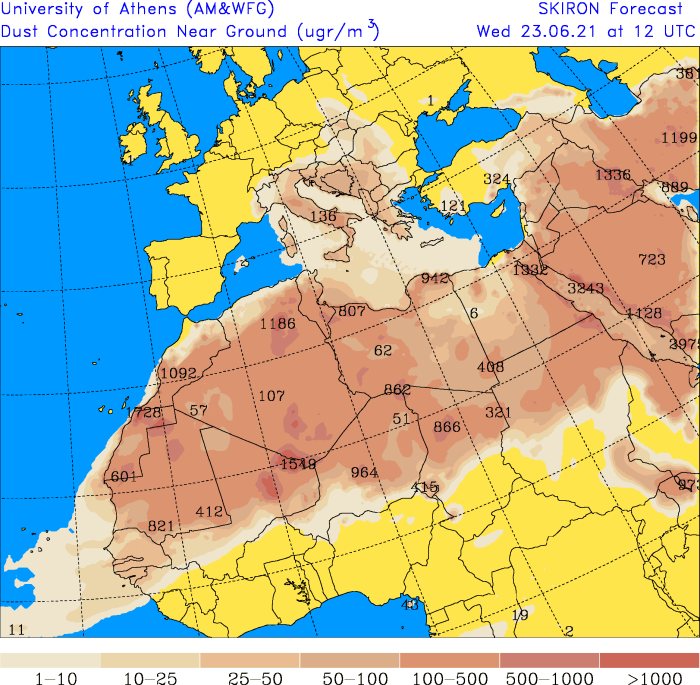
And yesterday evening saw a FB friend's post with explanation that it's dust/sand from Sahara (image below), with forecast saying that it'll reach maximum concentration tomorrow and only go down during the following weekend.

072.zoomdconc.png
 
Same in Sicily, @Truth&Forgiveness

As my guy and a very good friend together went out and about in the Etna region (Monte San Leo crater 1178m), it all was hazy milky outside. In the photo you look down towards the sea - which isn't. The double cone landmark is Monti Rossi. I happen to have saved the morning satellite image from 21 June, which shows very clearly the amount of Sahara dust blowing towards Italy and the Balkan countries.

In that direction very hot air blew up, too. Giving Palermo 42°C [107.6°F] (21 Jun), and the others on 22 June; Near Bari, Italy 40°C [104°F], Catania, Sicily 38°C [100.4°F], and the same temperature in many other Balkan countries like Albania, Serbia, Bosnia etc. - which all where the hottest places in Europe.

Scirocco, the winds that make you crazy...


20210620_205604.jpg

IMAGE-2021-06-23-18_27_49.jpg
 
After a ridiculously cold April and May, there was a two-week heatwave in Western Poland where I've been staying. But early this week the temperature went from 34 C to 19 C overnight and we now have early 20s. Last night was very cold, I was outside with the dogs until late and I got really chilly.

I checked the forecast for next week and the temperature is forecasted to drop to 17-18 degrees. Today is the day school ends and I remember it normally being very sunny and warm back in the day when I was at school. Apart from temperature being lower than it should be at this time of the year it's also overcast and it rains a lot. If the sun is shining it's ploughing its way through thick clouds.

Just recently I had a heated exchange with a friend who is a global warming believer. My question about how exactly it is possible to have the coldest April in a century in many parts of Europe, followed by equally crappy May, when we are said to have 10 years left before we roast in hellfire on Earth remains unanswered - while she remains convinced we have global warming. I guess it's true what they say: you can't fix stupid. And that's despite the fact that she's a member of Mensa :rolleyes:
A powerful tornado in the Czech Republic.
Several hundred houses destroyed, roads blocked.
There are fatalities and many injured.
The strength of the tornado is estimated at F4.
They say it's the strongest phenomenon in the country's history.


Poland also had similar phenomena including hail the size of a tennis ball.
Roofs ripped off and cars destroyed.


All at the same time yesterday afternoon.

Translated with www.DeepL.com/Translator (free version)
 
The last few day's temperatures are around 32-36C but it feels much hotter. No wind co cool down. The atmosphere is not clear. It is full of sand or dust. The sky is yellowish all the time. All this makes is feel much hotter and unpleasant. I remember summers when temperatures were over 40C. Now the sun feels different.
Just 2 weeks ago it was cold. At night and in the early morning it was chilly. Not this heatwave or dust wave makes the weather very unpleasant.
 
Where I Live the Southern BC and indeed the North Western continent of the North American land mass, we are indeed into a scorcher, with temperature estimates well above 10OF (still can't get my head around the decimalization issue).

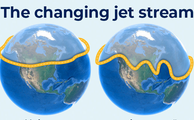
I am reminded of the Jet Stream, and it's changes, concerning weather and climate abnormalities. If I am not mistaken, SOTT in older web pages had images of projected changes in the jet stream..

Now this has come to pass.

For example, in the Prarie provinces of Canada they are experiencing unseasonably cold for this time of year.

Reminds me of this post of SOTT, could this be an explanation?

 
Sur la Côte d'Azur en France, finalement il n'y a pas eu d'orage, il fait toujours aussi beau avec des températures supportables 19° le matin et 28° l'après midi... L'eau de mer est à 22°...

On the French Riviera, finally there was no storm, the weather is still nice with bearable temperatures 19° in the morning and 28° in the afternoon... The sea water is at 22°...
 
Perhaps such extreme events are becoming more frequent as northern air masses clash with hot southern air over regions such as Europe, which are colder than they used to be.

May, June, beginning of July

are very powerful, dynamic months for large scale thunderstorms over Europe, due to that there are still some chilly pockets of colder air left. It doesn't require particularly cold airmasses, to make T-storms go berserk over Europe ! As of now we don't have particularly cold airmasses over Europe, or at least not colder than normal.

Instead it is the movement of particularly warm airmasses northwards/northeastwards which create a lot of dynamics when they reach middle Europe, because there is no "cap", and therefore nothing that prevents them from growing rapidly into the sky. Over South Europe on the other hand, along with summer - a capping is becoming increasingly stable.

Albeit the there is plenty of energy over the Mediterranean Sea Area, the cap often prevents ignitions of thunderstorms. Unless there is a "cold air drop" in the middle atmosphere moving into the area - adding unstable conditions, and breaking the "capping" in the atmosphere. It then only takes an ever so slightly cooler airmass, to make thunderstorms to grow even over Southern Europe (during summer). But for most of the time, you have stable conditions there.

If you like, you can study past satellite charts and you will see**, that every year in the end of spring, beginning of summer - there is a peak of thunderstorm activity - with absolutely huge mesoscale thunderstorm system growing almost daily.


South Europe in Autumn

Another peak happens over south Europe in the end of September and October, when colder air is starting to pull down from middle to South Europe, clashing with the extreme hot air in the South. But also when the general movement of warm, moist air goes northwards to regions with high mountains along a coast.

That is when we often see these horrendous rainfalls dumping up to 400-600 mm [16-23.6 inches] in places like east coast of Spain, French Riviera, Gulf of Genova (!!), Sicily and Calabria.

What also plays in there, is the dominating wind direction interacting with geographic / topographical features plus the energy generated from peak warm sea temperatures - adding to the severity of torrential rainfalls during autumn in the South. The best example i can think of is the Gulf of Genova, Italy, because very easily all bad comes together "in that corner". When "V" shaped thunderstorm systems appear between Sardinia and Genova - those act like feeding tubes for severe weather, which get "stuck" at the coast due to the mountains.

These dynamics happen every year !

Some years more than others. I know of extreme rainfall events, which where not even mentioned in the media, because the spotlight was on (weather related) deaths from flooding at the french Riviera, while Sicily got 650 mm rain - totally unnoticed !

Keep in mind, there is of course more to the whole process of when, why and how large scale thunderstorms explore over Europe. I tried to scale it down.


Europe Satellite Images Archives:

Eumetsat IR Satellite Images • 2016-21 (larger, tilted angle)

Eumetsat Water Vapor Satellite images • 2017-21
Eumetsat Natural Colors, Satellite images • 2017-21
Eumetsat Airmass Satellite Images • 2017-21
Eumetsat IR satellite Images • 2017-21
Eumetsat E-View Images • 2017-21
• Eumetsat Airmass B&W images • 2017-21

I am sure there are other archives (and I hope there are), but these are the one i could come up with directly.
 
Here in SW France, we had a nice week of warm weather, almost summerlike, then it cooled down again after a week of rain off and on, with morning lows of 14 C or so. But when it isn't cloudy, it is pleasant enough, just not like summer. It's supposed to get up to 29 today. I sure hope so. I'd like to get back to my delayed aqua-gym!
 
Back
Top Bottom