You are using an out of date browser. It may not display this or other websites correctly.
You should upgrade or use an alternative browser.
You should upgrade or use an alternative browser.
What's the weather where you are?
- Thread starter Maia
- Start date
Just had two separate massive dumps of rain here in Victoria, AU within couple of hours. The water was pouring down in buckets and it was real stormy. I think I saw rain falling almost horizontally. Our garage got flooded within 2 mins which is very rare. I was starting to fret a litte ie if it had kept up like that for another 30 mins, the house would probably have been flooded too. Article below.
 7news.com.au
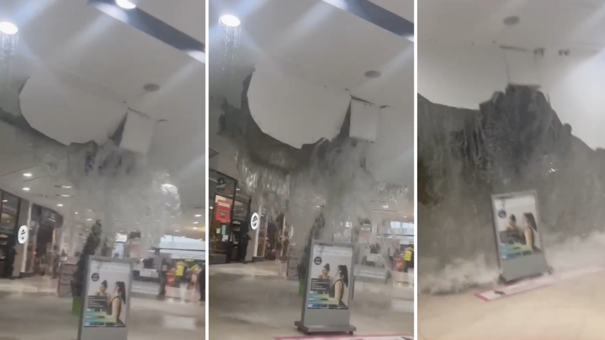
‘Dangerous’ storms bring wild winds and heavy rain to Victoria
A shopping centre roof has collapsed in Melbourne as forecasters warn there’s more to come.
7news.com.au
Just had two separate massive dumps of rain here in Victoria, AU within couple of hours. The water was pouring down in buckets and it was real stormy. I think I saw rain falling almost horizontally. Our garage got flooded within 2 mins which is very rare. I was starting to fret a litte ie if it had kept up like that for another 30 mins, the house would probably have been flooded too. Article below.
‘Dangerous’ storms bring wild winds and heavy rain to Victoria
A shopping centre roof has collapsed in Melbourne as forecasters warn there’s more to come.
Yikes, glad it didn't get any worse at your place! These storms were kind of weird... were they a lot more localised than storms usually are here? For the last two days we (also in Victoria) had the weather reports saying rain, when there was none. Yesterday the weather thing on my mobile phone said a "severe thunderstorm" was currently happening at my location, while the sky was clear and sunny.. We did finally get some stormy weather today, lots of good lightning.. But only a couple short bursts of rain.
Brrrrr!!!!!! In my neck of the woods-Moose Jaw Saskatchewan-it's been REALLY COLD for about the past week: -32 to -34 with the wind chill during the day, 6-7 degrees colder in the evening. Last Wednesday night it got down to about -50. Can't smoke in my apartment or anywhere in the building, so it's outside huddled in a corner with other smokers. I've never smoked a cigarette so fast in my life.
In my neck of the woods-Moose Jaw Saskatchewan-it's been REALLY COLD for about the past week: -32 to -34 with the wind chill during the day, 6-7 degrees colder in the evening. Last Wednesday night it got down to about -50. Can't smoke in my apartment or anywhere in the building, so it's outside huddled in a corner with other smokers. I've never smoked a cigarette so fast in my life.XPan
The Living Force
Stockholm, Sweden
8 Jan 2022
We have had something like "On and Off" weather during the past 2 weeks. A couple days of mild weather, in which all snow melted, mixed with brief very cold periods. The last cold period was yesterday morning, in which the temperatures went down to -9° to -16°C (15.8°F to 3.2°F) in the larger Stockholm area, followed by a beautiful, sunny morning, but then a weather front knocked at our door - with whole lot of milder air, as well snow.
While I am writing, in the early hours of 8 Jan 2022, the temperatures are hovering around +0.5°C (32.9°F) and more snow has come down (very pretty because every little tree branch is covered !) - yet, it will all go mush (and dull) quickly, as the temperatures will climb further.
We then expect that a very mild period is looming ahead of us: with temperatures possibly up to +8°C (46.4°F) in the Stockholm area. The vast realms of ice cold air over Canada, inducing many storms over the warm Atlantic, racing eastwards - pulling in over Europe and Scandinavia, like cars on a highway - creating mild weather. At the same time, the Russian coldpole - which usually is the counter balancing equivalent to the Canadian one in winter and normally keeping the mild Atlantic air at bay, but for the moment largely is missing. That explains why mild air can penetrate the nordic space so freely.
But in all - nothing unusual is going on up here.
PERLOU
The Living Force
A Cagnes sur Mer en France, nous avons un très beau temps ensoleillé sans aucun nuage, la matin il fait un peu frais mais l'après midi nous avons 14°... Temps normal sur la Côte d'Azur au mois de Janvier...
In Cagnes sur Mer in France, we have a very nice sunny weather without any clouds, in the morning it's a little bit cool but in the afternoon we have 14°... Normal weather on the French Riviera in January...
In Cagnes sur Mer in France, we have a very nice sunny weather without any clouds, in the morning it's a little bit cool but in the afternoon we have 14°... Normal weather on the French Riviera in January...
XPan
The Living Force
a little correction
Stockholm, Sweden
9 Jan 2022
I was wrong about the "snow quickly turning into mush" part... The snow didn't really disappear, despite temperatures up to +2°C (35.6°F) yesterday. To my surprize it even stayed in the trees without sliding off. So, before we get that very mild +8°C period here in Stockholm, we still have two-three days left with freezing temperatures... and snow (which is definitely prettier to the eye)


Prognosis by Swedish SMHI
Stockholm, Sweden
9 Jan 2022
I was wrong
about the "snow quickly turning into mush" part... The snow didn't really disappear, despite temperatures up to +2°C (35.6°F) yesterday. To my surprize it even stayed in the trees without sliding off. So, before we get that very mild +8°C period here in Stockholm, we still have two-three days left with freezing temperatures... and snow (which is definitely prettier to the eye) Prognosis by Swedish SMHI
Benjamin
The Living Force
For the past 17 days (since Dec. 24) here in central Alberta, CA we have been living in around -25C to -41C (-13F to -41.8F) temperatures with a short warm up on Jan. 1-2. There's about 16-20 inches (~40-50 cm) of snow on the ground. Two days ago we started warming up and right now it's +7C and raining. It looks like the rest of the week is going to be pretty warm with a return to 'normal' temperatures the week after:

Last edited:
Palinurus
The Living Force
Due to atmospheric circumstances explained below, the Netherlands was surprised today with beautifully colored sunrises in many places. Sit back and enjoy!
Source (in Dutch): Bloedrode zonsopkomst zorgt voor prachtige plaatjes
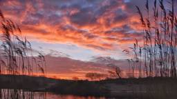
Dawn in Zandvoort - Gerard Boukes/NOS

In Ravenswaaij by the river Lek - Cynthia van Leusden/NOS

Beautiful sunrise in Hellevoetsluis - Simone Wiersma/NOS

On the Linge in Rhenoy - Chris Biesheuvel/NOS
A beautifully colored dawn in Vlissingen - Anne-Marie van Iersel/NOS
Explanation:
Source (in Dutch): Bloedrode zonsopkomst zorgt voor prachtige plaatjes
Dawn in Zandvoort - Gerard Boukes/NOS
In Ravenswaaij by the river Lek - Cynthia van Leusden/NOS
Beautiful sunrise in Hellevoetsluis - Simone Wiersma/NOS
On the Linge in Rhenoy - Chris Biesheuvel/NOS
A beautifully colored dawn in Vlissingen - Anne-Marie van Iersel/NOS
Explanation:
The red color has to do with lots of tiny water droplets suspended in the atmosphere. Early in the morning, there is often a lot of moisture in the lower layers of air, because especially at this time of year, at night, with little wind, fog or mist can easily form.
As the sun rises, the sun's rays travel a long way to your eye because of its low position. On that path are millions of tiny water droplets that scatter and refract the sunlight. The red colors in the sunlight are scattered the least and those colors therefore reach your eye the best and therefore you perceive that red color.
Today we also have to deal with clouds higher up in the sky. The low sun shines beautifully on those clouds from below and that delivers magical images.
Here's a video I took today of the Garonne river. The river is about 2kms out the back of us. This video is taken on a road out of Castelsarrasin (the local town) further along its course. But the situation is the same along much of it. Over the previous few days, a LOT of rain fell in the Pyrenees mountains, a lot of which ended up in this river that has its source there and empties into the Atlantic at Bordeaux.
The river height is obviously variable, but it's not very deep over all. Near us the average is just 50cms (20 inches). The recent rainfall added about 5 meters or about 15 feet.
The river height is obviously variable, but it's not very deep over all. Near us the average is just 50cms (20 inches). The recent rainfall added about 5 meters or about 15 feet.
Last edited:
C
Cleopatre VII
Guest
It is relatively typical winter in Wrocław in the west of Poland. Snow has already fallen, but there is currently no snow.
In winter, however, I often feel worse because of the polluted air.
In winter, however, I often feel worse because of the polluted air.

Trending content
-

-

-
Thread 'Coronavirus Pandemic: Apocalypse Now! Or exaggerated scare story?'
- wanderingthomas
Replies: 30K -