What's the weather where you are?

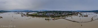
🍀here in ireland we have a storm warning
also big thunder storms last night - shook the ground bigtime !

Screenshot 2025-12-08 at 17-26-33 Met Éireann - The Irish Meteorological Service.png


Storm Bram will bring very strong to gale force southerly winds with the strongest winds along the coast.

Impacts:
• Flooding of low-lying coastal areas, especially during high tide
• Wave overtopping
• Difficult travel conditions
• Debris, loose objects displaced
• Outdoor events impacted
• Power outages


Valid: 07:00 Tuesday 09/12/2025 to 15:00 Tuesday 09/12/2025
 
In my location, we are under a winter storm warning. It will be snowing from 11:00 AM and will continue with some breaks throughout the day and night, with temperatures currently at -1°C, but dropping to -17°C in the early hours of the following day. Lows for the next few days will remain between -17°C and -16°C.
kLfR9apv.jpg

Let It Snow! Let It Snow! Let It Snow! ❄️⛄❄️

 
Here in western Washington we are having historic flooding. The town I live in became an island for 2 days and this has only happened years ago. Here is a pic of Duvall, wa from last Thursday Dec. 11th
I read about the atmospheric river that has gone through that area. It said that there were more on the way. I used to live in Arlington, WA in the foothills, and roads into Arlington would flood after some heavy rain. I can only imagine what it is like around there now.

Hope you are not having any problems with all that water. Stay safe.
 
Well we've had our second fall of snow so far this winter. Very chilly outside, and I had to run some errands earlier today. Man, I nearly slipped on a couple of occasions on the compacted snow on the pavements. It was certainly energising going for a 5 mile walk, and the shops were very quiet.

However, the landscape looked beautiful when I woke up this morning, and I'm guessing the local schoolkids had the day off!
 
Stockholm, Sweden
7 January 2026 • 17:30 (-7°C)


Let it snow, let it snow, let it snow... 🎶⛄
And boy, snow we got aplenty. Especially in some places, far far away from the Norwegian mountains. Usually you get the deepest snow depths in the extreme North (most of the time), which is right at the border between Sweden and Norway, kalled Katterjåkk / Riksgränsen. Which reported this morning 75 cm.

This time however, it is a place ("Kungsberget") which lies around 170 km NW of Stockholm, a bit inland not far away from the coastal town of Gävle, with a whopping 92 cm snow.

Here you see a snow depth chart with 7 days in between; 1 Jan. vs 7 Jan. 2026

snowdepths_Sweden_20260101.png
snowdepths_Sweden_20260107.png


It is funny how little cyclones
insignificant looking on satellite charts can dump huge amounts of snow in relatively little time. The snow depth in the larger Stockholm region are quite different from place to place. The City reported 22 cm this morning, while 7 km to the south, where I live, I measure around 28-30 cm. A bit further away both to the NE as well to the SW, places like Rimbo reports 55 cm, and Gnesta 65 cm !

Since the Baltic Sea is still an open see, snow "cannons" took up the latent energy from the water, transporting it as snow shows inland. Like a feeding mechanism - a snow effect which is well known in the US at the Greater Lakes.

Here some photo impressions:
Last night i had an education night at my work as a subway driver at the Metro in Stockholm. On my way there, it snowed pretty strong, and that went on for another 2-3 hours. As i exited the place, walking a couple kilometers to a busstation that hopefully would bring me closer to home (and it did) - the walk was to me like a fairy tale. Again i was 9 years old, stomping through the snow, whistling little songs and felt like the happiest... (and thanked the universe, for letting me experience this - and i loved it all the way into my bones... vibrating).

It just felt MAGIC !

PS: If some photos are a bit "heavier" in kilobytes - it is because the finer details a photo has (like many tree branches for example), the heavier the JPG gets, despite compressing images very strongly.

Going back 7 days starting from there:

2026-01-01-00-02-41-Fireworks.jpg
1 January 2026, 00:02 at our balcony - barely any snow (perhaps 1 cm)


2026-01-02-21-11-41-Stockholm,-Slussen,-Gamla-Stan,-snow.jpg

2 January 2026, early evening in the middle of Stockholm, as we were out having dinner with our Sicilien visitors


2026-01-02-22-11-50-Mariella.jpg

2 January 2026, late evening - in the southern suburbs, Mariella from Sicily was enchanted about snow on every tree and bush branch while in Stockholm


2026-01-04-17-46-09b-moon.jpg

4 January 2026, After a couple days of snow and overcast wether, the clouds started to break up, and La Luna came through


2026-01-06-05-33-07.jpg

6 January 2026, at 05.45 - coming home from work. it begun snowing quite a lot ... adding another 5-6 cm i guess


2026-01-07-03-54-49.jpg

6 January 2026, at 03.54 - after the education night, i walked home, passing my old neighbourhood near the Globe Arena. The sky was very bright, the wind calm, and the snow cover made even the ugly look magic


2026-01-07-04-00-31.jpg


2026-01-07-04-01-09.jpg

6 January 2026, at 04.01.... well, it was simply magic to experience the ambience, while walking through the villa area of Enskede...


2026-01-07-04-04-34.jpg

You just have to giggle of joy, especially from a child's view - when seeing so much beauty coming down "just like that". Everything is silent, everyone is sleeping... and the world becomes for a moment or two, endless, open and limitless.
 
What a winter wonderland @XPan, thanks for sharing the pictures & the update. Meanwhile in the antipodes and in complete contrast to parts of the northern hemisphere, we are in the midst of a heatwave. Temperatures in Perth almost 50*C, Melbourne 44*C and Sydney is sweltering too, with a very high risk of bushfires.
 
Back
Top Bottom