Crazy Storm Weather and Lightning - Global

Hurricane Fiona: Canada hit by 'historic, extreme event'​


Hundreds of thousands of people have been left without power, after Storm Fiona hit Canada's coastline.

Fiona was downgraded from a hurricane to a tropical storm on Friday.

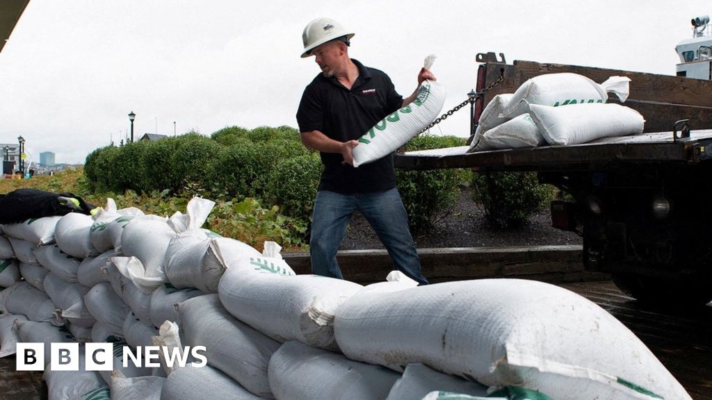
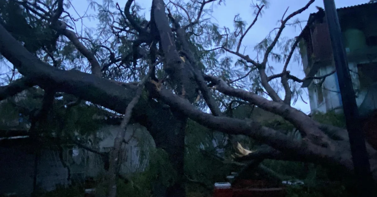
But parts of Nova Scotia, Prince Edward Island and New Brunswick still experienced torrential rain and winds of up to 160km/h (99mph), with trees and powerlines knocked down.

Prime Minister Justin Trudeau said the situation was critical, and promised to provide support through the army.

Officials have yet to share reports of fatalities or serious injuries, but authorities are dealing with extensive flooding.

In a briefing Mr Trudeau described Fiona as "a very powerful and dangerous storm" and said the army will be deployed to help with assessment and clean-up efforts. His government has already responded positively to a request by Nova Scotia authorities for assistance.

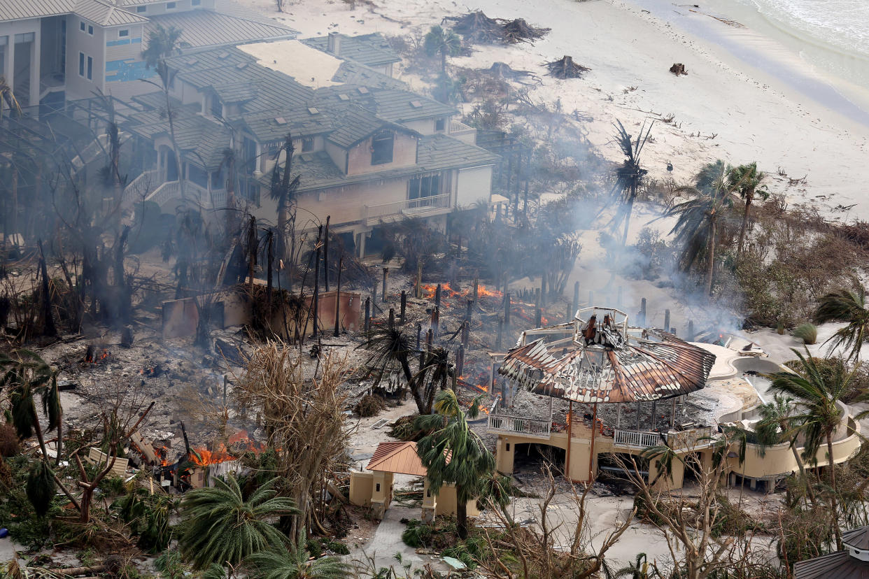
In Port aux Basques, with a population of 4,067 on the southwest tip of Newfoundland, intense flooding saw some homes and office buildings washed out to sea, local journalist Rene Roy, told CBC. The area is under a state of emergency.

"This is hands down the most terrifying thing I've ever seen in my life," Mr Roy said.

He added that many homes were left as "a pile of rubble in the ocean right now", adding: "There is an apartment building that's literally gone. There are entire streets that are gone."


Officials later confirmed that at least 20 homes had been lost.

And the Royal Canadian Mounted Police said a woman was rescued after being "tossed into the water as her home collapsed" in the area. They said another report of a women being swept out from her basement had been received, but conditions remained too dangerous to conduct a search.

Power companies have warned that it could take days to restore electricity, as wind speeds remain too high to start work on downed power lines.

Severe hurricanes in Canada are rare, as storms lose their energy once they hit colder waters in the north and become post-tropical instead. But pressure in the region is predicted to be historically low as Storm Fiona hits, making way for a heavier storm.


▪︎Philippines

Super Typhoon Noru barrels toward the Philippines, forcing evacuations near Manila​

A super typhoon barrelled toward the Philippines on Sunday and was on track to slam into the heavily populated main island of Luzon, forcing the evacuations of coastal towns, authorities said.

Super Typhoon Noru was packing maximum sustained wind speeds of 185 kph (115 mph) after an unprecedented "explosive intensification," the state weather forecaster said.

The storm, the strongest to hit the Philippines this year, is expected to continue strengthening as it makes landfall around 80 kilometers northeast of the sprawling capital Manila in the afternoon or evening local time.

The Philippines is regularly ravaged by storms, with scientists warning they are becoming more powerful as the world gets warmer because of climate change.

Weather forecaster Robb Gile said Noru's rapid intensification was "unprecedented." The agency said winds increased by 90 kph in 24 hours.

Noru comes nine months after another super typhoon devastated swaths of the country, killing more than 400 people and leaving hundreds of thousands homeless.

Noru could have wind speeds of up to 205 kph when it makes landfall, the weather bureau said.


▪︎Japan

Typhoon Talas lashes central Japan, reportedly killing two as thousands evacuate​


A typhoon has lashed central Japan with torrential rain and fierce winds, killing two and leaving tens of thousands of households without power, the Kyodo news agency reported.

Shizuoka city, south-west of the capital Tokyo, was hit especially hard, seeing a record 417mm of precipitation since the rain started on Thursday, the Japan Meteorological Agency (JMA) said.

Winds at the centre of the Typhoon Talas were blowing at about 65kph, with peak gusts of about 90kph, it said.

A man in his 40s was killed in a landslide and a 29-year-old man was found dead after his car plunged into a reservoir, Kyodo reported.

Power was also cut to about 120,000 households, supplier Chubu Electric Power Grid Co said, adding that a landslide had knocked over two electricity pylons.


▪︎Caribbean and Gulf of Mexico

Florida prepares for hurricane as tropical storm Ian grows over Caribbean​

Florida residents on Saturday were bracing for a heavy tropical storm that weather experts warn could become a major hurricane.

Tropical storm Ian is poised to intensify into a hurricane within a few days after forming on Friday over the southern Caribbean. The storm could cross over into parts of Cuba before heading to Florida by the middle of next week, according to forecasts.

“Ian is forecast to be a major hurricane over the eastern Gulf of Mexico on Tuesday and Wednesday as it approaches the west coast of Florida,” the National Hurricane Center wrote, noting that experts expected “significant to rapid intensification” for the storm as it crossed the north-western Caribbean Sea.

Tropical Depression #9 strengthens and #TropicalTropicalStorm #Ian forms in the Caribbean Sea.
-Winds 65km
-555km SE of Kingston #Jamaica 🇯🇲.
Moving W 20km/h, possible hurricane conditions for Cayman Islands 🇰🇾 next Monday.
September 24/02:00h

The forecast scenario guide would have it enter the Gulf of Mexico through the Yucatan channel even without hitting the western end of Cuba.

carousel of tropical cyclones 4 from the Atlantic and one more from the Pacific

20220925_002524.jpg
 
▪︎Venezuela

Tornado in Caracas? Strange meteorological phenomenon surprised residents of La Trinidad

Residents of La Trinidad in Caracas reported this Sunday an unusual meteorological phenomenon that caused astonishment and fear among some of the witnesses, beyond the rains that lashed the capital city.

Through social networks, citizens released a video showing how the clouds form a kind of tornado that spins at high speed.

Several Twitter users blamed climate change
for the unusual phenomena that have been witnessed in recent weeks.

The phenomenon lasted several seconds and apparently did not touch the ground.

This Saturday there were heavy rains in Caracas, accompanied by thunderstorms and even hail in some areas of the capital.

In view of this situation, security agencies called for caution to drivers who must travel in these conditions.

Elsewhere, the thunderstorm caused the collapse of a tree in Colinas de Santa Monica, where it fell on a van and completely blocked the road. Part of the fence of a residential building was also damaged.

A funnel cloud or possible tornado captured during a storm this Sunday in La Trinidad #Caracas, Venezuela.

▪︎ Cuba

Hurricane Ian hits Cuba with rains and winds of more than 200 kilometers per hour and is headed for Florida

The phenomenon is causing damage in the western third of the island, with power outages and suspension of most land and maritime traffic due to rainfall and gusts.

Hurricane Ian, now a category three (out of five) on the Saffir-Simpson scale, made landfall early Tuesday morning on the western tip of Cuba with winds of 185 kilometers per hour (km/h).

According to Cuba's Meteorological Institute (Insmet), the hurricane made landfall at around 3:24 local time (7:24 GMT) between the municipalities of La Coloma and Cabo Francés at a speed of 20 km/h (12 mph).

According to Insmet, Ian will cross the island from south to north in about four hours, returning to the sea between Port Hope and St. Lucia, already on the northwest coast, at about 8:00 a.m.

Ian will strengthen as it emerges in the Gulf of Mexico as a major threat to Florida (USA) in the form of storm surge, wind, rain and tornadoes.


EXERCISE EXTREME CAUTION 🌀
The #Huracan #Ian turns into a powerful.
MAJOR HURRICANE Category 3!
It's moving right now over western Cuba 🇨🇺
-Winds 205km/h
-10km south of #PinalDelRío.
WARNING with the strength of its winds, dangerous swells and #rain.
 
▪︎Hurricane Ian in Florida.

The hurricane came ashore as one of the strongest storms ever to strike Florida, moving across the state with damaging winds, heavy rains and storm surges that left people trapped.

Millions of Florida residents faced an uncertain night as wind, rain and storm surge from Hurricane Ian pounded the southwestern coast and moved inland on Wednesday, knocking out power to more than 1.8 million customers statewide.

A storm surge of up to 12 feet submerged cars, knocked over houses and trapped residents near where the hurricane came ashore off Fort Myers, Fla. Some places remained too dangerous for water rescues, officials said, adding that they were taking down addresses to deploy resources once it was safe.

Ian is among the most powerful storms to strike the United States in decades, and Gov. Ron DeSantis said it would go down as one of the strongest in Florida history. It was just shy of Category 5 status as it made landfall about 3 p.m., but had been downgraded to a Category 3 by Wednesday night, with winds of 115 miles per hour. Follow its path here.


Big Disaster In Rijeka, Croatia; Great Flood Brings Disaster in Croatia, People Trapped Some Die​


Heavy rains in Rijeka caused massive flooding throughout the city and a lot of traffic problems. Parts of the city remain without electricity.

"In Rijeka, around 7pm, heavy rain started to fall, which flooded the city center. Many requests were received for pumping water. Traffic is closed on Franje Račko, koljić and Fiumara Streets," the Croatian Civil Protection Service of the Interior Ministry announced on Twitter.

In less than two hours, the area of the city was "wetted" with more than 140 millimeters of rain per square meter. RIJEKA was hit by a strong rainstorm this evening, leaving downtown streets flooded, traffic jammed, and all emergency services on the ground.

The storm caused the sewers to not receive all the rain, so the streets were flooded. The manhole cover also came off, causing several cars to get stuck.

Apparently, some roofs of houses in Croatia, particularly in Rijeka, collapsed and classroom attics were flooded.

The Primorsko-Goranska Police Administration Headquarters, the area of the ticket booth, was also flooded. storm in Croatia Floods in Rijeka: People trapped in cars, one person died, buildings also damaged In Rijeka.

around 19:00, heavy rain began to fall which flooded the city center. The Croatian MUP Directorate of Civil Protection earlier warned about the amount of rainfall in the Rijeka and Gospi regions. and the Institute of Hydrometeorology issued first orange and then yellow warnings for the area due to thunderstorms, according to 24sata.

Traffic chaos emerged on Wednesday night after heavy rains created torrential flows. It rained continuously for two hours. There is chaos in traffic, difficult to drive due to heavy current. The city suffers from traffic jams, especially on the access roads around Rječina.

Also article on HR SOTT here: Rijeka pod vodom zbog jakih kiša; poginuo muškarac, zarobljeni auti, oštećene zgrade -- Sott.net

From the article (machine translation):

Rijeka was hit by a strong rainstorm tonight, so the roads in the city center are flooded, traffic is blocked, and all emergency services are on the ground. The storm sewers could not accept all the rain, so the streets were flooded. Manhole covers were also knocked out, so some cars got stuck in the openings.

As it turns out, part of the roof of the First Croatian Gymnasium in Rijeka fell and the attic classrooms were flooded. The headquarters of the Primorsko-Goranska Police Administration, i.e. the area of the counter hall, was also flooded.

Rijeka police reported that they received a report at around 19:30 that a man was found in a torrent under a car. By the time the ambulance arrived, the man had died. The body was sent for an autopsy.

...Parts of the city remained without electricity.

People are "trapped" in their vehicles and traffic is blocked. Many readers report the problems they have encountered in traffic, from broken manholes to torrents that make normal driving impossible.

From the flooded playground in the center of Rijeka, firefighters and gathered citizens evacuated the children who had found themselves in the area that began to fill with water during the flood, Novi List reports .

...As portal Fiuman found out from the parents of some students, the heavy rain caused problems in the First Rijeka Croatian Gymnasium in the city center. The roof could not withstand so much rain, and there was water penetration. As a result, the students were instructed to leave the gymnasium and sent home immediately.

The premises of the Rijeka Public Fire Brigade were also flooded.

...The mayor of Rijeka and the police of Rijeka appeal to the citizens not to leave their homes and, if they are already in their cars, not to try to drive through torrents of water.


...In just over two hours, the city area was "soaked" with over 140 millimeters of precipitation per square meter . This is an exceptional amount, which is clearly shown by the data of DHMZ, according to which the September average for the usually rainy Rijeka is only slightly more than 170 millimeters.

From today's update:

In the area of the city of Rijeka, more than 200 mm of rain fell , of which, according to data from the DHMZ automatic station, 95 mm fell in just one hour . We will have to wait a little longer for official data, but it is possible that some precipitation records have been broken.

Last night, exceptionally heavy rain also hit part of central Istria, and the northern part of Pazinština, Buzeština and Ćićarij was particularly affected, where more than 100 mm of rain fell in a short period of time. The Černehi station thus measures 102 mm, and with 79 mm Livade and Mekiši near Vižinada also stand out.

As a result of the heavy rain, the water level of the reservoir lake Butonige rose by 2 meters, and the river Mirna swelled and the water level at Ponte Porton rose by an incredible 5 meters!


Videos from the article:


▪︎United States

September 29/11:00h
Devastating #Huracan #Ian still as Tropical Storm heading out into the Atlantic, expected to strengthen again.
-110km/h winds
-70km E of Orlando
Hurricane warning issued for entire South Carolina coastline 🇺🇸

It seems that this dog has been abandoned to its fate by its owners.

Ft Myers Beach effectively gone, almost no emergency crews yet. These poor people need so much help...in the aftermath of Hurricane #Ian.

▪︎Mexico

The National Meteorological Service (SMN) of the National Water Commission (Conagua) reported this morning that tropical storm 'Orlene' is located off the coasts of Jalisco and Colima, moving towards the west-northwest. It is expected to make landfall in the next few hours.

Tropical #TropicalStorm #Orlene strengthens now better organized over the Mexican Pacific.
-Winds 75km/h
-465km SSW of #Manzanillo, #Colima Mexico 🇲
Moving WNW 17km/h
Attentive to its evolution and trajectory
September 29/10:00h
 
▪︎ United States

Hurricane #Ian strengthens over the Atlantic.
Threatens Carolinas and Georgia with catastrophic storm surge, flooding and high winds
-140km/h winds
-285km SSE of #Charleston South Carolina 🇺🇸

▪︎ México

Forecast for Friday and Saturday tropical storm #Orlene will increase in Hurricane with a well defined eye bands of very strong showers will affect Jalisco Colima Nayarit Sinaloa and Durango.

▪︎ Venezuela

Torrential rains hit #Barquisimeto region in Venezuela.
Civil Protection in Barquisimeto, Lara state, reported that the rains recorded during the afternoon of Tuesday, September 27, caused flooded roads, power failures and fallen trees to be recorded in several areas of the region.
 
I watched a 1m video report of the consequences of the huricane (Ian) in Florida, the fact that it has sucked up the water of the golf of Mexico, which is something the guy never saw before. But the problem is that this 1m clip is private and i can't link it here and did not find it on youtube. But I found other clips/videos which mention this, so here are some :


I watched a 1m video report of the consequences of the huricane (Ian) in Florida, the fact that it has sucked up the water of the golf of Mexico, which is something the guy never saw before. But the problem is that this 1m clip is private and i can't link it here and did not find it on youtube. But I found other clips/videos which mention this, so here are some :

I saw a similar statement by another resident on Twitter, however other people who have lived there longer say that it has been known to happen during hurricanes. That said, it may be that this time it was more extreme, or that the location was was different.

Searching online i came across this news report about the reverse storm surge caused by hurricane Ian; these are just a few snippets:


The phenomena is called a "reverse storm surge." Storm surge is wind-driven, said David Zierden, the state climatologist with Florida State University's Center for Ocean-Atmospheric Prediction Studies.

Donna Bourgeois, the day manager at Angelo & Son's Seafood Restaurant, said she's never seen the tide so low. She's worked at Angelo's for 30 years.

Floridians could walk on what should be water as the hurricane pulled the ocean from the shore.

"It was just like a bathtub let the water out," she said. "Just, it was gone."
1664573061882.png
The tide started to come back in around 3:30 p.m. Thursday, and it was coming in fast.

Zierden said Florida saw reverse storm surge during Hurricane Irma
, but it's not only caused by hurricanes.

Reverse storm surge can happen during cold fronts, too.
 
Update from Sundance:

Hopefully this hotspot holds up. First things first, we are surrounded by the grace of a loving God, and we are thankful.

To begin updating day #2 on the ground in Southwest Florida (SWFL) allow me to please remind everyone to take these storms seriously and take all the advanced preparations needed to protect yourself and your family. You can never overprepare. Additionally, if you did evacuate from the area, stay where you are. There’s no need to come back into the recovery zone and there are virtually no utilities (electricity, water) operating in most areas.

Working today with a search and recovery team from Fort Walton Beach, Florida, there are multiple agencies from around the Southeast sending resources. We are incredibly grateful, and every resource is a blessing.
...

Unfortunately, there are many people missing, and frantic out of state families looking for their loved ones. Hopefully, those missing were just last-minute evacuees that don’t know people are looking for them, and/or people with no way to communicate their status. Local radio stations are broadcasting names and addresses of missing persons in the hope that people can call in with information. This is why a communication plan is so critical for anyone in an extreme weather impact zone.

 
Back
Top Bottom