Volcanoes Erupting All Over

Volcanic activity raises Japanese island, exposing sunken Second World War ships
An undersea volcano and related tectonic activity near the Ogasawara island chain in Japan has raised the island of Iwo Jima, exposing a fleet of partially sunken Second World War ships.

Aerial footage from the Japanese All-Nippon News Network reported the strange phenomenon on Monday.

The ghostly fleet of wrecks, which can often be seen partially submerged, now appear beached on the small volcanic island’s black sandy beaches.
The island, the name of which translates to “sulphur island” was the site of a battle in February 1945, when more than 100,000 US soldiers fought 20,000 Japanese defenders over its volcanic terrain and the imposing Mt Suribachi.

https://youtu.be/uTGGhRrHo0Q
note: you can access to english subtittles with this video

Add:

https://youtu.be/8XZufC1E9Z4
The investigation team dispatched to Nishinoshima, which was born in the Ogasawara Islands, returned and released the latest video taken there.
 
I'm just wandering if perhaps it may be more practical to merge this thread with "Earthquakes around the world" to save double posting since they are the same subject. Just thinking out loud.
 
2 days later and sulphur levels have come down quite a lot. They are down to 2882 tons/day SO2 as can be seen on the live feed from TV Canarias.
The day after I wrote the above, the SO2 output increased to 10000 tons for a few days and is this morning down to 7000 tons. A few more areas are being evacuated and CO2 emissions are 1224 tons per day. Enough to keep Greta awake at night ;)

Below are 3 screenshots with details of what is written above:

SO2 emissions:
Volcano 21st of October 2021.gif

CO2 emissions:

Volcano 21st of October 2021 - 2.gif

Evacuations:
Volcano 21st of October 2021 - 3.gif


Added: Highlights to make it clear what the screenshots were showing.
 
Last edited:
I'm feeling for all those people who have already lost their properties, but after watching the video where we can appreciate the numerous houses still standing up awaiting their fate in midst of the growing lava flows I can't even imagine how their owners manage and do survive to a kind of stress like that one. A little reminder of how optimistic my life situation still looks like when confronting it with the challenges La Palma's people have to endure.


From Sept. 11th. until Oct. 17th., both relocated earthquakes and ground deformations can be seen at GNSS stations near the eruption site. No near end at sight.

 
I'm feeling for all those people who have already lost their properties, but after watching the video where we can appreciate the numerous houses still standing up awaiting their fate in midst of the growing lava flows I can't even imagine how their owners manage and do survive to a kind of stress like that one. A little reminder of how optimistic my life situation still looks like when confronting it with the challenges La Palma's people have to endure.

That is jaw-dropping drone footage.

Here's a compilation of recent footage taken at ground level, showing the La Palma volcano's lava flow eating everything in its path:‌

 
Navy to deploy two seabed seismometers on La Palma
The hydrographic ship Malaspina of the Navy has arrived at Santa Cruz de la Palma to assist in the deployment on the west coast of the island of two seabed seismometers (OBS) broadband and obtain records with them from marine areas away from the focus of the eruptions. The ship set sail on October 11 from the Rota Naval Base (Rota), the Navy said in a press release.
El Consejo Superior de Investigaciones Científicas (CSIC) solicitó a la Armada, a través del Real Instituto y Observatorio de la Armada (ROA), una plataforma para el despliegue en la costa de poniente de la isla de dos OBS de banda ancha.

Seabed seismometer OBS
Description
The ocean bottom seismometer (OBS) is a type of seismic monitoring system that locates the geophone directly on the seafloor. In marine geophysical research, the OBS seismometer can be used to observe the natural and artificial seismic profile. The observation results can be used to study the velocity of the crust and mantle and the kinetic characteristics of subduction zones, trenches and the evolution of oceanic depressions. The results are useful for studying seismic tomography of natural earthquakes, seismicity and predicting earthquakes.
Applications
As a seismic activity data collection system, our seismometer is suitable for recording and investigating natural and man-made earthquakes. Therefore, it is widely used in oil exploration and deep ocean structure investigation.
Translated with deepL
 

Hundreds of people evacuated on La Palma due to the advance of the lava from the Cumbre Vieja volcano​

10/21/2021, 8:28:20 PM


According to the Emergency and Security Directorate of the local Government, the cities of Las Martelas (Llanos) and Marina Alta, Marina Baja, La Condesa and Cuesta Zapata (Tazacorte) were the evacuated areas.


About 7,000 people have been evacuated in the regions affected by the eruption, which has devastated more than 860 hectares.


The new neighborhoods evicted are on the way from the wash to the sea, in the northern area of the lava delta that is being formed several days ago.

Update #Pevolca to Thursday, October 21:

➡ Right now the air quality is good in most of the island, although particles in suspension continue in the places closest to the eruption.

In this type of atmosphere, the use of FFP2 masks is recommended.

- Cabildo de La Palma (@CabLaPalma) October 21, 2021

The president of the Canary Islands, Ángel Víctor Torres, assured this Wednesday that his Executive and the administrations seek to alleviate the damage of the eruption.

"With the mayors of affected municipalities we have addressed the availability of land for housing and planning issues, and at the same time continue to acquire more homes to continue responding to the housing emergency on La Palma," he wrote on his Twitter account.

He also indicated that in the coming days, the Governing Council will approve no less than 100 million euros (more than 116 million dollars), which can be expanded, to rebuild the island and that would be contemplated in the 2022 Budgets.

"We cannot fight to prevent the lava from getting where it is going to go," he said.


“We have no mechanism for this to change.
We are at the mercy of the volcano, "he added.


Some media are confusing the concepts of INTENSITY and MAGNITUDE of earthquakes.

Yesterday there was talk of possible earthquakes of intensity VI in La Palma (widely felt by the population);

in no case of 6.0 magnitude earthquakes.


Thanks pic.twitter.com/EqkNZZ0ksO

- Geological and Mining Institute of Spain (@ IGME1849) October 21, 2021

The seismic activity also intensified and in recent hours has picked up again.

The National Geographic Institute (IGN) registered 38 earthquakes since midnight.

The highest magnitude was 4.3 and intensity IV in Villa de Mazo, with a focus at a depth of 37 kilometers.
 
The day after I wrote the above, the SO2 output increased to 10000 tons for a few days and is this morning down to 7000 tons.
It wasn't my intention to make a running commentary on the SO2 levels, but after they yesterday decreased to under 3000 tons, they have now increased greatly to 28745 tons per day. A 10 fold increase and the most it has been so far.

Volcano 22nd of October 2021.gif
For some reason the amount of lava which is coming out from the volcano has stayed the same since the beginning, namely 66m3/s. My guess is that it is a very rough estimate and something which is very hard to quantify.
 
La Palma Cinder Cone Rises As Inflation Decreases - Vulcano Volcano - Etna - Kilauea -Iceland Up
Premiered 56 min ago


[10/21/2021] Seismic activity on La Palma, from the day of the eruption until today, October 21 in the morning. With data from
@IGNSpain ,@lapalmaopendata and @CopernicusEMS . #VigilanciaLaPalma#LaPalma#ErupciónLaPalma#VolcandeLaPalma

[10/21/2021 13:06] Complete sequence of lava flow growth, with data from @CopernicusEMS#EMSR546 , until October 21 at 13:06. #erupcionlapalma#VolcandeLaPalma#LaPalma

La Palma eruption: this is how the unpredictable volcano-islands that cross the oceans are like
Premiered Sep 21, 2021 En español
With just 700 square kilometers and 80,000 inhabitants, La Palma is one of the smallest islands in the archipelago, but the one with the most volcanic activity since the 15th century. In total there have been 8 eruptions, the last 3 in the last seventy years.

Volcanic eruptions are manifestations of the energy found in the interior of planet Earth. However, most of the volcanoes in the world have nothing to do with the eruptions that occur in the Canary archipelago. About 90% of volcanic activity is found near the edges of the tectonic plates that make up the earth's crust.

But there are other types of volcanoes, found inside oceanic plates in places called "hot spots." In total, about 30 hot spots are known throughout the earth's surface. The Canary Islands archipelago sits above one of these hot spots. Columns of magma rising from a depth of 3,000 km below the bottom of the Atlantic Ocean.

1634965528001.png

Volcano Watch — The Canary Islands “mega-tsunami” hypothesis, and why it doesn’t carry water

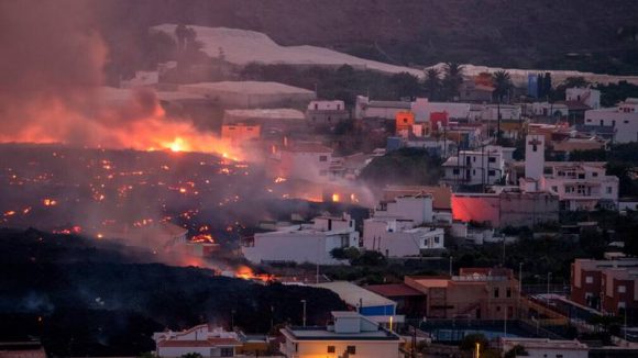
The recent eruption on La Palma, in the Canary Islands, has stimulated speculation that the volcano might collapse, creating a tsunami that would devastate the east coast of North and South America. But is such a scenario possible or likely?

Release Date: October 21, 2021
Volcano Watch is a weekly article and activity update written by U.S. Geological Survey Hawaiian Volcano Observatory scientists and affiliates.

“Volcano Watchers” are probably aware that an eruption began on La Palma in the Canary Islands on September 19. The eruption style is similar to Hawaiian eruptions, and both locations share the potential for flank collapse and tsunami.

Basaltic ocean islands, such as the Island of Hawai‘i and the Canary Islands, tend to experience catastrophic landslides every few hundred thousand years—a discovery first made by USGS Hawaiian Volcano Observatory Scientist-in-Charge Jim Moore in the early 1960s! A significant portion of an island is removed during collapse and has the potential to displace tremendous amounts of seawater, generating local tsunami waves that are thought to be over 100 meters (300 feet) high. From this understanding grew a notion that collapsing volcanoes—particularly in the Canary Islands—could generate ocean-wide “mega-tsunami.”

In 2001, an academic paper suggested that collapse of La Palma could result in tsunami waves up to 25 m (about 80 feet) high along the east coasts of North and South America. This scenario made headlines in the media, which inaccurately depicted a huge wave devastating New York City.

But can collapses actually generate these “mega-tsunami” far from their sources? Subsequent research casts doubt on this idea.

The Canary Islands “mega-tsunami” scenario assumed a single, coherent, massive collapse block that reached a high velocity very quickly. Ocean floor mapping surrounding the Canary Islands, however, indicates that collapses instead occur in incremental or piecemeal fashion. In addition, geomorphologists found, via slope stability analysis, that the potential collapse volume is much smaller than was simulated by the 2001 paper.

Tsunami modeling has also advanced considerably since 2001. Studies of landslide-induced waves show that they travel at different speeds and interact more across long distances, leading to smaller wave height far from their sources. Better knowledge of ocean bathymetry, island and coastal topography, and the transfer of energy between slide blocks and water also contributed to more accurate modeling.

These new simulations suggest that the maximum wave height along the east coast of the Americas from a “worst-case scenario” collapse of La Palma would be on the order of 1-2 m (3-7 feet)—still hazardous, but similar to common storm surge.

A lack of geologic evidence also calls the “mega-tsunami” hypothesis into question. Tsunami leave characteristic sediment deposits on the coastlines they impact. But no such deposit has ever been identified on the east coasts of North and South America.

Collapses of Canary Island volcanoes are rare, occurring on timescales of hundreds of thousands of years, and should be preceded by signs of flank instability: increases in earthquakes and ground surface deformation. Canary Island volcanoes also erupt regularly—La Palma last erupted in 1971 and 1949—and slope stability analyses conducted at La Palma indicate that the structure is stable. The volcano would have to grow significantly before a collapse was likely.

This abundant evidence refutes the “mega-tsunami” hypothesis, demonstrating that it does not hold up to rigorous examination. However, tsunami that are generated by volcanoes are a real process and a significant threat. For example, the 1883 explosive eruption of Krakatau, in Indonesia, caused a local tsunami that killed tens of thousands on nearby coastlines. In 2018, a smaller eruption and collapse of Anak Krakatau, an island which grew in the 1883 caldera, also resulted in a local tsunami that killed hundreds.

Local tsunami can also be generated by other volcanic processes. On the Island of Hawai‘i, lava delta collapse at lava-ocean entries can cause small tsunami that impact areas adjacent to the delta. Slip on the fault underlying Kīlauea’s south flank, associated with M7–8 earthquakes, caused local tsunami in 1868 and 1975 that took lives. These are processes that have happened repeatedly in human history; they will happen again, and their associated hazards deserve our attention.

While the scientific view of the “mega-tsunami” hypothesis has evolved in the years since 2001, that original work led others to start investigations that contributed new knowledge that advanced our understanding of landslides and tsunami generated by volcanoes. In this way, the story is a marvelous example of exactly how science happens!

Volcano Activity Updates

Kīlauea volcano is erupting. Its USGS Volcano Alert level is at WATCH (https://www.usgs.gov/natural-hazards/volcano-hazards/about-alert-levels). Kīlauea updates are issued daily.

Lava continues to erupt from a single vent in the western wall of Halemaʻumaʻu crater. All lava activity is confined within Halemaʻumaʻu crater in Hawai‘i Volcanoes National Park. Sulfur dioxide emission rates remain high and were estimated at around 2,700 tonnes per day on Oct. 17, 2021. Seismicity is elevated but stable, with few earthquakes and ongoing volcanic tremor. Summit tiltmeters have remained relatively flat over the past week. For more information on the current eruption of Kīlauea, see Recent Eruption (usgs.gov).

Mauna Loa is not erupting and remains at Volcano Alert Level ADVISORY. This alert level does not mean that an eruption is imminent or that progression to an eruption from the current level of unrest is certain. Mauna Loa updates are issued weekly.

This past week, about 114 small-magnitude earthquakes were recorded below the summit and upper elevation flanks of Mauna Loa—the majority of these occurred at shallow depths less than 10 kilometers (6 miles). Global Positioning System (GPS) measurements show no major deformation over the past week. Gas concentrations and fumarole temperatures at both the summit and at Sulphur Cone on the Southwest Rift Zone remain stable. Webcams show no changes to the landscape. For more information on current monitoring of Mauna Loa, see: https://www.usgs.gov/volcanoes/mauna-loa/monitoring.

There were 9 events with 3 or more felt reports in the Hawaiian Islands during the past week. Listed here are the felt events with magnitudes of 3 and above: a M3.6 earthquake 91 km (56 mi) WNW of Kalaoa at 7 km (4 mi) depth on Oct. 17 at 10:56 p.m. HST, a M3.1 earthquake 4 km (2 mi) SW of Pāhala at 36 km (22 mi) depth on Oct. 17 at 7:34 p.m. HST, a M3.3 earthquake 4 km (2 mi) E of Pāhala at 35 km (21 mi) depth on Oct. 17 at 12:58 p.m. HST, a M3.8 earthquake 2 km (1 mi) S of Pāhala at 37 km (23 mi) depth on Oct. 17 at 5:52 a.m. HST, a M3.2 earthquake 4 km (2 mi) ENE of Pāhala at 0 km (0 mi) depth on Oct. 16 at 5:41 p.m. HST, a M3.0 earthquake 5 km (3 mi) SSW of Pāhala at 32 km (19 mi) depth on Oct. 16 at 2:08 p.m. HST, a M3.0 earthquake 4 km (2 mi) S of Pāhala at 33 km (20 mi) depth on Oct. 16 at 1:35 p.m. HST, and a M3.6 earthquake 10 km (6 mi) E of Pāhala at 31 km (19 mi) depth on Oct. 15 at 12:03 a.m. HST

HVO continues to closely monitor Kīlauea’s ongoing eruption and Mauna Loa for any signs of increased activity.

Please visit HVO’s website for past Volcano Watch articles, Kīlauea and Mauna Loa updates, volcano photos, maps, recent earthquake info, and more. Email questions to askHVO@usgs.gov.

Volcano Watch is a weekly article and activity update written by U.S. Geological Survey Hawaiian Volcano Observatory scientists and affiliates.

Opinion:

YOWUSA.COM, 23-October-2007 Marshall Masters
We are presenting this alarming Nostradamus - La Palma Mega-tsunami analysis by Professor Chris Lock, Ph.D., making it available in the hope it will help spur Western governments into action, and we're not alone. NOVA, DISCOVERY, NATIONAL GEOGRAPHIC and many more reliable sources are also sounding the alarm.

There is still a modicum of time to alleviate or prevent this impending catastrophe. To waste it on inaction or pointless debate will cost millions of lives, because nature's countdown clock is ticking away!

In June of this year, Professor Lock offered himself as a guest to be on Marshall's Cut to the Chase Internet radio show, with the purpose of talking about his La Palma Mega-tsunami research.

A British-born Language professor in Japan, his analysis of the Nostradamus quatrain unequivocally demonstrates that Nostradamus was both prescient and clear and in his prediction.
 
Back
Top Bottom