Crazy Storm Weather and Lightning - Global

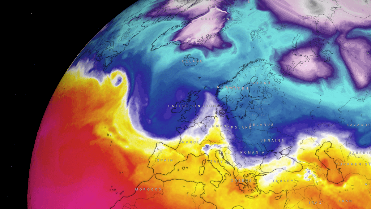
Moscow experiences the biggest snowfall in almost 150 years and Siberia prepares for 50 degrees below zero​


Since yesterday, the Russian capital has been experiencing the biggest snowfall in 145 years, which in twelve hours has left a blanket of up to 40 centimeters of snow in some neighborhoods, while Siberia prepares to face temperatures of up to 50 degrees below zero.

“The rainfall record in 145 years for December 3 has been broken,” said the meteorologist Roman Vilfandcited by the TASS agency.

Due to the heavy snowfall, which continued throughout the night, although with less intensity, 60 flights had to be canceled or postponed in the Moscow airports.

Due to heavy snowfall, 60 flights had to be canceled or postponed at Moscow airports.
Severe weather ❄️ In #Moscu recorded the heaviest snowfall in nearly 150 years, which have left up to 40 centimeters of snow and will face temperatures of up to minus 50 degrees.

 
Blizzard historique au Nunavut / Historic Blizzard in Nunavut
Blizzard historique : cette région paralysée durant deux jours - MétéoMédia

Des vents dépassant les 100 km/h durant plus de 24 heures ont paralysé toute une région
Winds exceeding 100 km/h for more than 24 hours paralyzed an entire region

Très long blizzard​

Entre le 21 et le 23 novembre, une tempête d'une rare intensité a produit des vents se rapprochant de la force d'un ouragan, de la forte neige et un blizzard qui a duré près de deux jours sur les régions de Kivalliq et Kitikmeot au Nunavut. Les conditions de blizzard ont duré au moins 30 heures, mais des outils d'observations permettent de déterminer que la tempête a probablement sévi 48 heures, voire plus. Les vents ont été d'une violence rare, même pour cette région pourtant habituée à des conditions extrêmes. Pendant 27 heures d'affilée, on a signalé des rafales de plus de 100 km/h sur Baker Lake et de nombreux records de vitesse soutenue des vents et des rafales ont été battus à Kivalliq et Kitikmeot.

Very long blizzard
Between November 21 and 23, a storm of rare intensity produced winds approaching hurricane force, heavy snow and a blizzard that lasted almost two days in the Kivalliq and Kitikmeot regions. in Nunavut. The blizzard conditions lasted at least 30 hours, but observation tools allow us to determine that the storm probably lasted 48 hours or more. The winds were of rare violence, even for this region which is accustomed to extreme conditions. For 27 hours straight, gusts of over 100 km/h were reported on Baker Lake and numerous records for sustained wind speed and gusts were broken in Kivalliq and Kitikmeot.

Dommages et fermetures​

Un blizzard accompagné de vents aussi forts a évidemment causé des problèmes pour la population de la région. Plusieurs pannes ont été signalées, et des dommages à certains édifices ont été rapportés. Plusieurs habitants ont donc été privés de chauffage durant une bonne partie du blizzard. Les services gouvernementaux et municipaux, les écoles, et même certains commerces ont été fermés durant deux jours.

Damage and closures
A blizzard accompanied by such strong winds obviously caused problems for the population of the region. Several outages were reported, and damage to some buildings was reported. Several residents were therefore deprived of heating during a good part of the blizzard. Government and municipal services, schools, and even certain businesses were closed for two days.

Grande traversée​

Le blizzard a même traversé la baie d'Hudson pour frapper entre autres Akulivik au Québec, plus de 800 km plus loin. Malgré les conditions exceptionnelles, les habitants de cette région ont démontré leur résilience face au blizzard. Plusieurs travailleurs du secteur public ont continué leur piquetage sous les fortes rafales qui ont atteint 108 km/h. La rare circulation dans la ville se faisait en véhicule tout-terrain ou en motoneige. Un peu plus au nord, à Salluit, les rafales ont atteint 141 km/h, ce qui a égalé le record du 18 novembre 2015.

Great crossing
The blizzard even crossed Hudson Bay to hit Akulivik in Quebec, among other places, more than 800 km away. Despite the exceptional conditions, the inhabitants of this region demonstrated their resilience in the face of the blizzard. Several public sector workers continued their picketing under strong gusts which reached 108 km/h. The rare traffic in the city was by all-terrain vehicle or snowmobile. A little further north, in Salluit, gusts reached 141 km/h, which equaled the record of November 18, 2015.

Trop fort pour les instruments​

Et les vents ont peut-être été encore plus forts à certains endroits, mais n'ont pas pu être enregistrés. Les renseignements sur les vents ont en effet été interrompus pendant le blizzard en raison de pannes d'électricité dans certaines stations d'Environnement Canada. Il est possible que certaines données puissent être récupérées. On saura alors si d'autres records ont été surpassés.

Too strong for instruments
And the winds may have been even stronger in some places, but could not be recorded. Wind information was interrupted during the blizzard due to power outages at some Environment Canada stations. It is possible that some data can be recovered. We will then know if other records have been surpassed.

1701841672867.png
1701841683253.png


Cyclone Jasper - Special Sunday update for Queensland
Dec 9, 2023
Tropical Cyclone Jasper is aiming towards Cairns but severe weather may be anywhere from Mackay to Cooktown in the coming days.,We track the latest modelling from BoM, from the US and Europe as we start to fine tune the path of the storm - and the heaviest rain. It looks as though the slow movement of Jasper will give more uncertainty for timing, intensity and rainfall totals this far out - so our update on Monday will hopefully be even more precise.WeatherWatchTV will have updates each day this week for Cyclone Jasper until it has made landfall. We also have additional updates on X (Twitter): / weatherwatchnz

 
NOTICE ⛈️
Violent #storm with strong wind gusts in Bahía Blanca, #BuenosAires #Argentina 🇦🇷
Sadly they report 13 people dead, several injured and extensive damage.

Looks more like a supercell
There was a F1 tornado in Bahia Blanca.
The wind wind exceeded 150 km per hour and the damage is incalculable, it is moving to the Atlantic coast, with red alert !
Severe weather 🌧 In Bahia blanca Damage to Olimpo and Estudiantes stadium due to strong wind.
 
I have seen videos of people in Argentina who tearfully say they regretted voting for Milei. It seems that the human component (this is in terms of suffering, hopelessness and uncertainty) is wreaking havoc not only on the weather. Earthquakes have also been recorded.

And it is just beginning.

Edit And in the cosmic aspect the Sun is sending us enough electromagnetic energy to feed these climatic phenomena.​
 
Doing a quick search there were 3 earthquakes recently, all above magnitude 4.0. There was a 5.5 in Salta, Argentina on the 11th, another one in the same region on the 13th, and yet another one yesterday. This is near the border with Chile, in the Andes region north of both Argentina and Chile.
 
California and the entire West Coast to Alaska are reeling from the current atmospheric river.

California Storm Watch | Thunder overnight in Sacramento with more rain on the way
Dec 18, 2023
California Storm Watch: Heavy rain will come in waves through the day on Monday. The first round in time for the morning commute, then another in the afternoon, and another in the evening

A strong storm led to flooding in Cherry Grove, North Myrtle Beach, North Carolina - United States #NorthCarolina #Flood #Storm
#Climate


The thunderstorm complexes over Argentina

where absolutely humongous - while also fueled so called "V" shaped thunderstorms, which are the by far most dangerous types, because of their strong fueling dynamics. Also; it appears to me, that Argentina recently got weather situations that got repeated (with T-storms) - kind of developing in similar ways day(s) after.

What maybe is less obvious in these images below was, that the winds looked extremely strong over the Southern part of Argentina. This was easier to see in the animations of clouds.

Here are satellite images i gathered from the events last week:

1.jpg

1b.jpg

2.jpg

8.jpg

4.jpg

5.jpg
 
Wow!
Storms brewing as Christmas weather forecast takes a turn | 9 News Australia


TORNADOES of 2023 - Season of the Twisters
Nov 26, 2023
Tornado chasing documentary following the incredible storms during the 2023 storm season.

In 2023 there currently have been 1165 confirmed tornadoes in the United States (as of Nov 27). That's just under the annual average.

For some storm chasers, 2023 was a great year, for others, very challenging and disappointing. Though I documented 20 tornadoes, I personally fall somewhere in between as I missed the majority of the spectacularly photogenic tornado events in Iowa, Nebraska and Colorado.

The year was characterized by nontypical chase setups in fringe states like Mississippi, Arkansas, and Illinois as well as several hard to forecast long-range, upslope setups in Colorado, New Mexico, and Wyoming. Texas, Oklahoma, and Kansas had lower than average storm events it seems as the days of May Lee Low triple point set-ups rolling across the Plains were almost absent.

Remarkable supercell structures were abundant across the entire alley.
 
Last edited:
💨 “In Tiksi, children and women stay at home; due to the blizzard, school activities are canceled, daycare centers are closed, and women are not working. ‘Blizzard at a speed of 108 km/h is when strong wind blows away a healthy person.’ In the footage, a man tries to go, presumably to work, but the wind sweeps him away. 😱
📍Republic of Yakutia, Tiksi village, Far east Russia

Columbus, NE we had a Christmas Blizzard. Blizzard warnings all day.

Freezing after -40°C over northern Astana, #Kazakhstan (December 20, 2023). #Massive #Frozen #Ice #Climagram #Frozen.
 
Two hundred thousand lightning strikes recorded in Queensland Australia Weather up Evil ⚡⚡⚡⚡

Queensland’s Southeast Hit with Severe Thunderstorms Leaving 7 people dead, including a 9-year-old girl (Updated)
9 News Australia 12-26-2023
The southeast of Queensland has been smashed by severe thunderstorms, with intense wilds tearing down trees, destroying homes, and killing a woman.

Dec 26, 2023-Updated 4 hrs ago
Numerous major roads have been closed in eastern Colorado due to a blizzard that's rolling through bringing snow and strong winds to the state.

A storm that hit the mountains this weekend has continued to shift east, resulting in blizzard warnings and high wind warnings for much of eastern and northeast Colorado. Portions of I-70, along with most other major highways in the northeast quadrant of the state have been closed as a result. Due to blowing snow, visibility in this part of the state is severely reduced – to about a quarter-mile at times. Wind gusts are reaching around 60 miles per hour at times.

Screenshot 2023-12-27 at 04-00-22 Blizzard causes widespread road closures in Colorado includi...png

Map Credit: CoTrip.org (See the interactive map here)

Most blizzard warnings that have been activated are currently set to expire by Wednesday morning. Road conditions could impact Tuesday evening and Wednesday morning commutes. Find specific weather alert information on the National Weather Service website.

All road conditions are subject to rapid change. Find updates on the CoTrip website.

STAY INFORMED: Get free Colorado news with our daily newsletter Click here

A Historically close call for Denver snow records
 

After Gerrit, a Bomb Cyclone is Forecast for Ireland and the UK with a Winter Storm before the New Year​


A progressive weather pattern with strong zonal flow has been established over Europe. Resulting in intense Atlantic storms battering Western Europe as the New Year approaches. The first in line, storm Gerrit is underway today; the next, even more powerful, is forecast to arrive on Saturday as a bomb cyclone Henk.

The new winter storm is forecast to move across western Europe with strong to severe winds and heavy rain squalls on Saturday, moving further east across the North Sea. Blanketing southern Scandinavia and northern Baltic states with heavy snow before the New Year’s Day arrives.

Today, on Wednesday, Gerrit, the first intense storm of the progressive pattern evolving, is moving across Ireland and the UK, with several yellow wind and rain warnings in place, issued by the Met Office. The storm is expected to move through the country throughout the day.

Yellow warnings for wind are in place across the southern coast of England, in north-west England and Wales, much of Scotland and Northern Ireland. Wind warning areas can expect 50-60 mph gusts, up to 70 mph on high elevations and exposed coastal areas.

Storm Henk will be nearing Ireland on early Saturday morning with a well-defined frontal system during its rapid intensification. An associated warm front will move across in the morning, followed by a cold front in the afternoon and evening.

As the storm will be quite large, its wind effect will spread across most of Western Europe. Especially Ireland, Northern Ireland, and western Scotland have the most violent winds. Heavy rain and wind squalls will also blast Wales and southwestern England along the fast-moving convective line.

The peak wind gusts will likely reach 70-90 mph (110-140 km/h), with even higher gusts north of Scotland and west of Ireland where the pressure gradients will be the sharpest.

The cyclone’s core will move into the North Sea by Sunday morning and continue further east into Denmark and southern Sweden during the day.

Storm Henk will blast southern Norway, Sweden, southern Finland, and Estonia with Heavy Snow and Intense Winds


Back
Top Bottom