You are using an out of date browser. It may not display this or other websites correctly.
You should upgrade or use an alternative browser.
You should upgrade or use an alternative browser.
Crazy Storm Weather and Lightning - Global
- Thread starter mabar
- Start date
Facebook denies intentionally blocking searches for Cyclone Alfred
Despite hundreds of thousands of accounts talking about Cyclone Alfred on Facebook, social media giant Meta was blocking or hiding search results about the impending storm before being contacted by ABC NEWS Verify.
 www.abc.net.au
The platform is a key communication channel for emergency coverage in Australia and is used to help broadcast evacuation orders and other updates to residents during a crisis.
Tropical Cyclone Alfred is expected to make landfall between the Gold Coast and southern parts of Wide Bay region as early as Thursday evening as a category two cyclone.
It is forecast to bring destructive winds and the risk of life-threatening flooding.
According to Meta's own data, more than 300,000 accounts and pages on Facebook are posting about Cyclone Alfred. However, users who tried to learn more about it using the search term on the social media platform were coming up with empty or non-related results.
ABC NEWS Verify found the terms "Cyclone Alfred" led to a nearly blank page with a link to the "Climate Science Centre".
This hub contains general information and statistics about climate change but nothing about the impending cyclone.
Searches for the hashtag #cyclonealfred led to a blank page with an explanation: "Posts with cyclonealfred are temporarily hidden here. Some content in those posts goes against our Community Standards."
Advanced searches on Facebook, which typically produces more detailed results, were also unsuccessful.
But general searches about cyclones or "TC Alfred" did produce information and articles in the search results, indicating some kind of throttling about the term Cyclone Alfred specifically.
The office for Queensland's Minister for Police and Emergency Services Dan Purdie was unaware of the issue when contacted by ABC NEWS Verify.
A spokesperson said they would contact Meta about the issue.
The ABC first noticed the lack of results while searching for "Cyclone Alfred" on Sunday, and reached out to Meta on Wednesday.
After the publication of this story, a Meta spokeswoman said the issue had been resolved and blamed the lack of results on a technical glitch.
"Facebook has not intentionally blocked or hidden search results relating to Cyclone Alfred," she said.
"We did experience a technical issue, which our teams have been working to resolve, and relevant information should now be available for most users. We apologise for the mistake and hope everyone stays safe."
A spokesperson for communications minister Michelle Rowland said the issue has been raised with the social media giant.
"The Government was immediately in contact with Meta about the availability of information on Tropical Cyclone Alfred," they said.
"The information has been shared across Government for awareness and appropriate action."
The Queensland government has urged the community to visit its disaster monitoring website for the most up-to-date information.
Hailstorm in Air on the Adour (40)
The Oranges take on a locally "rotating" character in the southwest with deviation for certain cells (split) in relation to the main flow. Deviation in the southeast/northwest direction sometimes in relation to a flow rather oriented to the southwest. These cells sometimes give abundant hailfall of small size.
Excuse me and so that it is understood: between tomorrow and Tuesday the #borrascaJana will go into the kitchen.
The peninsula will end up being a hotbed of cumulonimbus clouds that will leave numerous storms with hail, warns meteorologist Sergio Escama.
 Entre mañana y el martes la borrasca Jana entrará a la España peninsular con todo un arsenal de tormentas
#orages accompanied by #grêle have been reported since this afternoon in Aquitaine, near the Pyrenees and also in the Midi-Toulousain region.Illustration at the end of the afternoon on the A64 motorway south of #Toulouse . Video via the Infoclimat Forums >
Succession of depressions in an atmospheric river which comes to persecute the Iberian Peninsula and Morocco.Origin from the Caribbean with a high precipitable water content.
 Météo Express on X ⛈️ Les averses tournent à l'orage dan...png")
The Oranges take on a locally "rotating" character in the southwest with deviation for certain cells (split) in relation to the main flow. Deviation in the southeast/northwest direction sometimes in relation to a flow rather oriented to the southwest. These cells sometimes give abundant hailfall of small size.
Excuse me and so that it is understood: between tomorrow and Tuesday the #borrascaJana will go into the kitchen.
The peninsula will end up being a hotbed of cumulonimbus clouds
that will leave numerous storms with hail, warns meteorologist Sergio Escama. Entre mañana y el martes la borrasca Jana entrará a la España peninsular con todo un arsenal de tormentas#orages accompanied by #grêle have been reported since this afternoon in Aquitaine, near the Pyrenees and also in the Midi-Toulousain region.Illustration at the end of the afternoon on the A64 motorway south of #Toulouse . Video via the Infoclimat Forums >
Succession of depressions in an atmospheric river which comes to persecute the Iberian Peninsula and Morocco.Origin from the Caribbean with a high precipitable water content.
Holly moly!
Major Sierra snowstorm to make for near-impossible travel

"The biggest storm window of the season is upon us! A consistent stream of storms over the next 7-10 days has the potential to bring us over 8 feet of snow!"
The possibility of over two dozen tornadoes, a high fire risk, and a blizzard.
Tornado in Orlando
This video shows the moment a tornado hit the FOX 35 Orlando studio
Major Sierra snowstorm to make for near-impossible travel
A powerful winter storm is set to slam the Sierra Nevada starting Tuesday evening, bringing heavy snowfall, strong winds and hazardous travel through Thursday, according to the National Weather Service.
A winter storm watch has been issued for the greater Lake Tahoe area and Mono, Lassen, eastern Plumas and eastern Sierra counties, with 2 to 3 feet of snow possible along the Sierra crest and 12 to 18 inches expected in lower-elevation areas. Winds gusting up to 70 mph could create “near whiteout conditions,” Monday’s forecast discussion said.
The storm system is predicted to bring some of the heaviest snowfall rates seen this season. Although it will likely contain less moisture than previous atmospheric river storms this winter, powdery snow should lead to higher accumulations.
“We are tracking more snow within this system,” said Gigi Giralte, a meteorologist with the weather service’s Reno office, noting February storms had area-wide impacts. “The last significant storm we had had multiple waves. This storm is bringing heavier snowfall rates, and we’ve got some larger snowfall totals we’re expecting right now.”
Because of the fluffier nature of the snow, there may be more volume. “We can get more accumulation just because the snowfall-liquid ratio is such that there’ll be more snow produced from one inch of liquid,” she added.
The weather service recommended drivers brace for widespread chain controls and nearly impossible travel along Interstate 80 at Donner Pass, Highway 50 at Echo Summit and other major Sierra passes.
The best travel window is through Tuesday, as conditions will likely deteriorate rapidly by Wednesday. Another weaker system is expected Thursday night into Friday, followed by a stronger storm Sunday into Monday.
Residents and travelers should take precautions ahead of the incoming storm. The National Weather Service’s Reno office recommends carrying an emergency kit with blankets, water, snacks and a flashlight in case of delays or road closures. Ensuring tires are properly inflated and carrying chains is crucial for those driving into the Sierra, as chain controls are expected to be widespread. Additionally, having a shovel, ice scraper and snow brush can help clear vehicles, if needed.
Travelers should check road conditions before departing using Caltrans QuickMap. For more information and updates, check weather.gov.
"The biggest storm window of the season is upon us! A consistent stream of storms over the next 7-10 days has the potential to bring us over 8 feet of snow!"
The possibility of over two dozen tornadoes, a high fire risk, and a blizzard.
Tornado in Orlando
This video shows the moment a tornado hit the FOX 35 Orlando studio
"A day two high risk has only been issued three times since 2006."
Rare tornado Southern California
Carrier Mills, Illinois
Tracking severe storms passing through Chicago area


 www.fox32chicago.com

 katv.com
Rare tornado Southern California
Carrier Mills, Illinois
Tracking severe storms passing through Chicago area
Tracking the storm: Thunderstorm watch issued for Chicagoland
Mark Strehl has your latest weather update!
VIDEO: Several hurt in multi-vehicle pile-up along Texas highway caused by extreme wind
Harsh wind caused a massive vehicle pile-up on a highway during a major weather event in Texas, with several people hurt.
katv.com

 The situation is under surveillance on Thursday, March 20. A new episode of turbulent autan winds is expected in the southwest. Gusts could reach 100 km/h in the #Pyrénées region, as well as between the south of Toulouse and the south of the Massif Central.
The actual location was not identified
Impressive images of lightning striking a few meters from a car this weekend as the violent #oranges struck the #USA! (Lexi Diesels video)
Europe
 General 7-day trend: Conditions for thunderstorms are likely to be particularly strong in the west and south of the country this week. Elsewhere in Europe, thunderstorms are mainly expected between Portugal and the Balearic Islands.
 developments to be followed in the daily medium-term forecast bulletins:
Impressive images of lightning striking a few meters from a car this weekend as the violent #oranges struck the #USA! (Lexi Diesels video)
Europe
General 7-day trend: Conditions for thunderstorms are likely to be particularly strong in the west and south of the country this week. Elsewhere in Europe, thunderstorms are mainly expected between Portugal and the Balearic Islands. developments to be followed in the daily medium-term forecast bulletins:Olivierlejardinier
Dagobah Resident
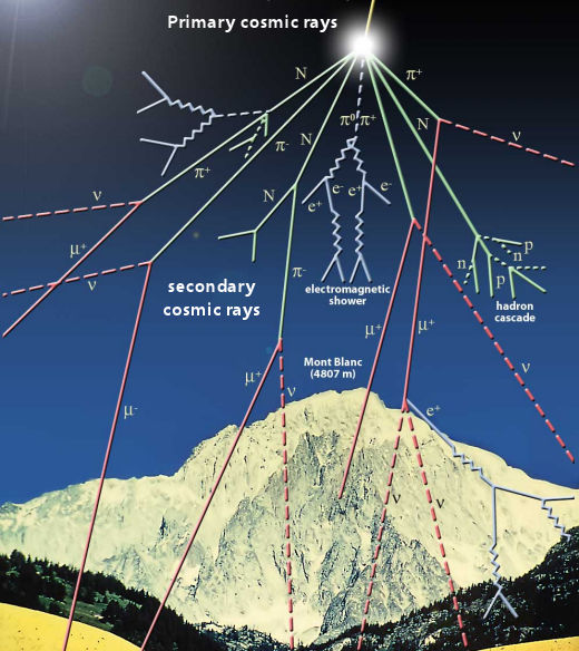
Recent study (03 March 2025) links lightning formation and cosmic rays (spaceweather.com March 21 2025) :
Electric fields in thunderclouds are often too weak to ignite a powerful discharge.
A new study just published in the Journal of Geophysical Research may have solved the mystery.
"We believe that that most lightning flashes in thunderstorms are ignited by cosmic ray showers," says the study's lead author Xuan-Min Shao, a senior scientist at the Los Alamos National Laboratory in New Mexico.
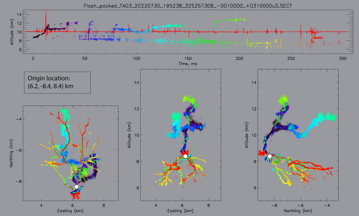
To investigate the earliest moments of lightning formation, Shao and colleagues built a radio interferometer named "BIMAP-3D." Consisting of an array of 8 antennas in Los Alamos, BIMAP-3D can make three dimensional images of lightning and pinpoint the bolts inside thunderclouds. Here's an example:
Caption: Colors in the image represent time. Blue traces the earliest moments of the bolt, while red denotes the end.
This is a lightning bolt from a massive thunderstorm that passed by Los Alamos on July 30, 2022. BIMAP-3D imaged more than 300 bolts during the 90-minute storm. It was a treasure trove of data.
The experimenters realized that some of the bolts they observed happened in parts of the storm where electric fields were too weak to cause the "Initial Breakdown Event" (IBE)--the initial spark that sets the lightning in motion. Modern theories of relativistic electron avalanche couldn't explain what they saw. Their suspicions soon focused on cosmic rays.
Cosmic rays are high energy particles that come from distant supernova explosions and other violent events across the cosmos. They strike Earth's atmosphere all the time, creating a secondary spray of particles called "cosmic ray showers." Regular readers are familiar with these showers because we routinely monitor them using Earth to Sky cosmic ray balloons over California.
One of the important things about cosmic ray showers is that they contain antimatter--positrons as well as ordinary electrons. The Los Alamos 3D lightning maps contained strong evidence for positrons. Electrons and positrons are bent in opposite directions by Earth's magnetic field, so they leave opposite imprints on the lightning's polarization, which BIMAP-3D also measured.
"It took me a while to figure this out," admits Shao. "I started with electrons only at the beginning, but could not explain the observations. With both electrons and positrons involved, all the observations can be consistently explained."
Positrons clinched the case for cosmic rays. "The fact that a cosmic ray shower provides an ionized path in the cloud that otherwise lacks free electrons strongly favor the inference that most lightning flashes are ignited by cosmic rays," the authors wrote.
In fact, it's still unclear how much of Earth's lightning is sparked by cosmic rays. Many more storms need to be studied with this method to improve the statistics. "This will require a lot of long-term and good quality lightning data," Shao says.
No electrical issues have been reported in Occitan, Southern France, since February 9, 2025.
However, the snow continues to fall in the higher elevations in the mountains
The storms were truly electric yesterday: with 10,000 lightning strikes, March 22nd is among the top 10 days in March with the most lightning strikes since 2015. Aveyron, Eure-et-Loir and Aude are at the top of the departments that received the most lightning.
complete storm stats:

Third day of bad weather near #Méditerranée where new #pluies thunderstorms are occurring this afternoon. We will have to wait until Wednesday to see more stable weather set in.
 Unwetter-Freaks on X Heute Nachmittag bewegten sich die ...png")
Severe Weather Threatens Tornado-Ravaged South On Sunday
However, the snow continues to fall in the higher elevations in the mountains
The storms were truly electric yesterday: with 10,000 lightning strikes, March 22nd is among the top 10 days in March with the most lightning strikes since 2015. Aveyron, Eure-et-Loir and Aude are at the top of the departments that received the most lightning. complete storm stats:Third day of bad weather near #Méditerranée where new #pluies thunderstorms are occurring this afternoon. We will have to wait until Wednesday to see more stable weather set in.
Severe Weather Threatens Tornado-Ravaged South On Sunday
XPan
The Living Force
Funny... my husband and I were talking about ball lightning yesterday morning, out of the blue. (I can't remember that we ever mentioned or discussed ball lightning before)Ball lightning spotted after lightning strike during Alberta storm.
Ball lightning is very interesting and not so much filmed phenomena. At the time there was apparently also a tornado in Alberta.
i.e.
Ball was seen in Rich Valley, Alberta, tornados in Lodgepole, Alberta and Drayton Valley, Alberta - about 150km distance.
On tornadoes and ball lightning:
 cassiopaeatranscripts.org
Q: (L) What is ball lightning?
cassiopaeatranscripts.org
Q: (L) What is ball lightning?
A: Electromagnetic spark. Pass from 4th to 3rd density.
 cassiopaeatranscripts.org
(Ark) Let me take opportunity to ask about ball lightning. Are they purely electric phenomena, or are they also related to consciousness or...?
cassiopaeatranscripts.org
(Ark) Let me take opportunity to ask about ball lightning. Are they purely electric phenomena, or are they also related to consciousness or...?
A: Transdimensional portals made manifest.
cassiopaeatranscripts.org
(Anart) Can I ask a clarification question on the tornado? If it's similar to ball lightning, does that mean they're both portals? Physical manifestations of portals?
A: Yes.
Q: (Perceval) Do people ever disappear in tornadoes?
A: Yes.
FWIW, I searched Twitter and found 2 people gone missing on that day in Alberta, although further away from either of the phenomena so perhaps it's not related:
This guy is from Saddle Lake, Alberta and this woman is from Airdrie, Alberta.
i.e.
Ball was seen in Rich Valley, Alberta, tornados in Lodgepole, Alberta and Drayton Valley, Alberta - about 150km distance.
On tornadoes and ball lightning:
Cassiopaean Session Transcripts Search
A: Electromagnetic spark. Pass from 4th to 3rd density.
Cassiopaean Session Transcripts Search
A: Transdimensional portals made manifest.
Cassiopaean Session Transcripts Search
A: Yes.
Q: (Perceval) Do people ever disappear in tornadoes?
A: Yes.
FWIW, I searched Twitter and found 2 people gone missing on that day in Alberta, although further away from either of the phenomena so perhaps it's not related:
This guy is from Saddle Lake, Alberta and this woman is from Airdrie, Alberta.
Benjamin
The Living Force
Ball was seen in Rich Valley, Alberta...
Here's the video of that big glowing sphere.
Edit: Oh, never mind. Already posted.
rognaill
Jedi
That sure looks like, lasted as long and popped at the end just like an American transformer popping on a distribution feeder.Here's the video of that big glowing sphere.
Edit: Oh, never mind. Already posted.
Trending content
-

-
Thread 'Coronavirus Pandemic: Apocalypse Now! Or exaggerated scare story?'
- wanderingthomas
Replies: 30K -

-
