Crazy Storm Weather and Lightning - Global

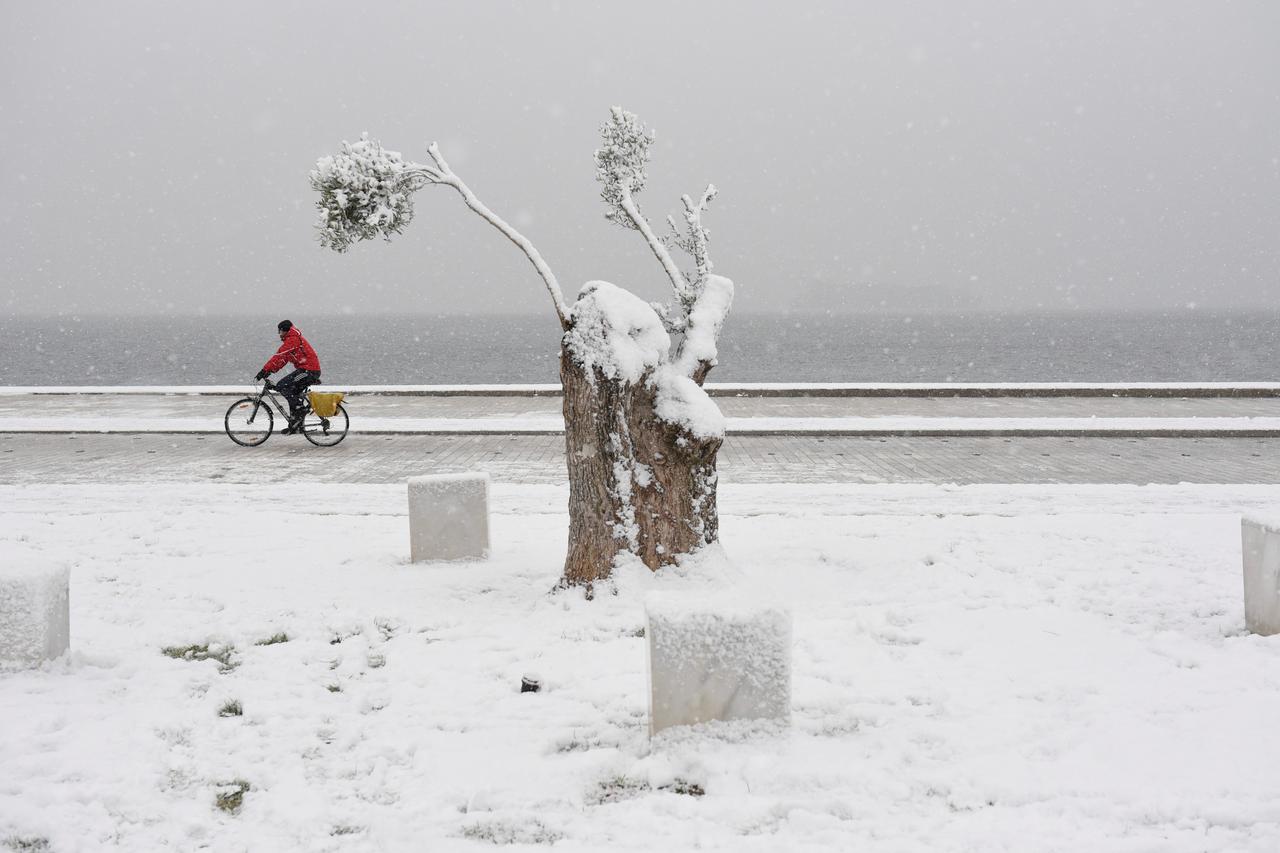
ATHENS - An elderly woman was found dead and two men were missing after blizzards hit parts of Greece, police officials said on Saturday.

January 5, 2019 - One dead, two missing after Blizzards hit Greece
One dead, two missing after blizzards hit Greece | Reuters
r
A man rides his bike during snowfall at the seaside promenade of Thessaloniki, Greece, January 4, 2019. REUTERS/Alexandros Avramidis

Temperatures in central and northern Greece have remained below zero for almost a week, during which time heavy snow has disrupted transport services and forced flights to be diverted in the north of the country.

The body of the 66-year-old woman was recovered from a car found overturned near a stream in Keratea, a region 45 kilometers southeast of Athens. Two men who had been in the car were unaccounted for.

“Her husband and one more man, who were in the same car, have been reported missing since Thursday when bad weather conditions prevailed in the area,” a police official said on condition of anonymity.

The Greek civil protection service has urged municipal authorities to be on the alert ahead of a further spell of cold weather expected to hit Greece on Monday.
 
http://www.spaceweather.com/ said:
WINTER SPRITES: Summer is the season for sprites. The strange red forms shoot up from the tops of intense thunderstorms, tapping the heat energy of the atmosphere to create exotic upward-directed lightning. So it came as a bit of a surprise on the night of Jan. 14th when Daniel Ščerba of the Czech republic photographed sprites in the dead of winter:


"These sprites were shooting up over a thunderstorm in the Adriatic Sea more than 700 km from my location," says Ščerba. In this map of weather radar data, the red arrow points from Ščerba's observatory to the storm. "In total, I photographed 16 sprites--my first of 2019."

What makes sprites appear in winter? Some researchers believe sprites are linked to cosmic rays: subatomic particles from deep space striking the top of Earth's atmosphere produce secondary electrons that, in turn, provide the spark that triggers sprites. Increasing levels of cosmic rays during Solar Minimum might explain why the red forms are spilling over into the "off-season."
 
Insane numbers as California, and the SF bay area gets hammered. Chaos nothing but pure Chaos! And, another hit for the C's.

Updates:
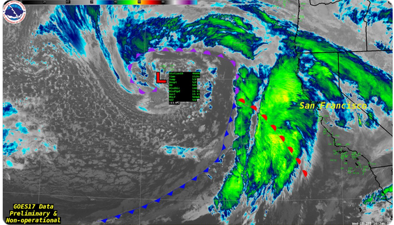
Satellite imagery shows massive storm poised to slam the West Coast
[SIZE=4]https://www.sfgate.com/weather/article/Satellite-imagery-GOES17-atmospheric-river-CA-13538594.php[/SIZE]
Published 9:44 am PST, Wednesday, January 16, 2019
BREAKING NEWS
53513b9008fd4bbd808ab3ee8a42ae77.png

Image 1 of 45
The National Weather Service Bay Area released an image of Wednesday's storm: "Check out this impressive #GOES17satellite imagery this morning. The low pressure system just passed near Buoy 006 with a pressure of 969mb."

19-car pileup leaves 35 injured as powerful storm hits Calif. 11:43 AM
Up to 80 inches of snow: Life-threatening blizzard to hit Sierra 12:02 PM
Huge Bay Area storm brings downed trees, flash flood watch 12:39 PM
Storm to unleash thunderstorms; 'People may see funnel clouds' 11:33 AM
One Bay Area spot could see 7 inches of rain in 24 hours 12:06 PM

 
Egypt’s capital Cairo and some of its port cities were hit by a severe sandstorm, with strong winds and heavy dust forcing the closure of several ports.

January 16, 2019 - Sever sandstorm hits Egyptian cities, ports
Severe sandstorm hits Egyptian cities, ports | Reuters

r
Women cover their face near the River Nile during a sandstorm in Cairo, Egypt January 16, 2019. REUTERS/Mohamed Abd El Ghany

Sources at Cairo airport said the storm had caused some delays.

The Red Sea Ports Authority closed the ports of Suez and Zeitiyat at 2 pm (1200 GMT) due to bad weather, wind and high waves.

In the Mediterranean city of Alexandria, Reda El Ghandour, a spokesman for the Alexandria Port Authority, said that the maritime traffic remained suspended for the fourth consecutive day in the ports of Alexandria and Dekheila.


Ski resorts left out in the cold Jan 15, 2019
Ski resorts left out in the cold

ST_20190115_BIGPIC15_4550956.jpg


Heavy snowfall in parts of Austria has left ski resorts buried under mounds of snow, as seen by this ski lift that serves the Hochkar ski area.

The mountainous area, about 150km west of Vienna, was declared a disaster zone earlier last week because of snow more than 3.5m deep.

The winter storm has left more than 2,000 people trapped in villages and ski resorts, and over 4,000 households without electricity.


January 15, 2019 - Australian state to pump oxygen into rivers as fish die
Australian state to pump oxygen into rivers as fish die

CANBERRA, Australia: An Australian state government has announced plans to mechanically pump oxygen into lakes and rivers after hundreds of thousands of fish have died in heatwave conditions.

1430136-1795212382.jpg

Water experts are meeting in Canberra to decide how the nation should respond to the crisis. (File/AFP)

Up to a million dead fish were found floating last week in the Darling River in western New South Wales state and the state government announced on Tuesday that 1,800 more rotting fish had since been found in Lake Hume in the state’s south.

Minister for Regional Water Niall Blair says 16 battery-powered aerators have been bought and would be placed in various drought-affected waterways after they are delivered by Wednesday.
 
Tornado Hits Havana Leaving At Least 3 Dead, Over 170 Injured - Cuba's President
28.01.2019

A tornado that tore through Havana left at least three people dead and 172 injured, Cuban President Miguel Diaz-Canel Bermudez said Monday.

"The damage is severe, so far we regret the loss of three human lives and are treating 172 injured," the president said on Twitter.
The victims are receiving assistance. The city was seriously affected by strong wind and rain. Damaged houses, fallen trees, overturned cars and power outages were reported throughout some parts of the city.


"In the morning of today an extratropical low has been formed in the Southeast of the Gulf of Mexico, from which a cold front extends towards south-southeast. A line of electrical storms can form in the next hours, which with the movement to the east of these systems will affect the western part of the country tonight and early in the morning," Havana's Institute of Meteorology reported as quoted by the IBT.


According to local residents, the tornado sounded like a jet engine when it hit Havana with strong winds, heavy rain and hail.


Cerro and Santo Suarez, Luyano, Via Blanca, Regla and Chibas were among the most affected areas.
 
Italy's A22 saw heavy snow on Saturday that paralysed traffic and created long queues of cars waiting to get to their destinations.

02/02/2019 - Firefighters rescued 200 people trapped in cars due to bad weather on an Italian motorway

Italy: Firefighters rescue 200 people trapped in snowy motorway

Queues on the route connecting northeastern Austria with Italy reached 16 km, a spokesperson for firefighters in the province of Bolzano in northern Italy told Reuters.

Firefighters evacuated people who were sitting in their cars under freezing temperatures, said the spokesman. No casualties were reported.

The bad weather caused several cars not prepared for winter to swerve, blocking circulation.

An avalanche had also hit a part of that motorway on Saturday morning but luckily no vehicles were on its way.

A lot of cars were still trapped by Saturday night even though traffic started to circulate again in the afternoon.
https://www.euronews.com/2019/02/02...eople-trapped-in-snowy-motorway#spotim-widget
Published on Feb 2, 2019 (1:01 min.)
 
A strong winter storm struck Colorado and other parts of the central United States on Wednesday, sending hurricane-force winds and heavy snow across the region, meteorologists said.

March 13, 2019 - Strong Winter Storm Classifies as ‘Bomb Cyclone’ in Colorado

Strong Winter Storm Classifies as ‘Bomb Cyclone’ in Colorado
items.[0].image.alt


The fierce winter weather, part of which classified as a “bomb cyclone,” pummeled Denver and other areas in Colorado and rapidly intensified throughout the day as it pushed east and north, the National Weather Service said.

Heavy rains turned to snow, blizzard conditions and high winds and affected parts of the country from the Central Rockies across the Plains, and from the Mississippi Valley into the upper Great Lakes, including Wyoming, Nebraska, Kansas and South Dakota.

In Colorado, Gov. Jared Polis declared a state of emergency, making more resources available to react to the storm. Winds reached a high of 94 miles per hour, and some areas saw up to four feet of snow. Visibility reached near zero, and travel plans were disrupted throughout the state. Schools were closed on Wednesday in Denver, Littleton and several other cities.

Late Wednesday afternoon, Jim Kalina, a meteorologist for the National Weather Service, said that the storm had “already slowed down” in Denver. “Further east,” he added, “we still have a band of snow and winds at 70 m.p.h.”

Dodge City, Kan., broke a record for low atmosphere pressure that had stood for more than a century, according to Vanessa Pearce, a meteorologist with The National Weather Service in Kansas.

The storm was expected to make its way through Kansas, Nebraska and move northeastward toward Iowa, the Weather Service said. In Colorado, the storm qualified as a “bomb cyclone,” also known as a winter hurricane, according to the National Weather Service.


March 13, 2019 - Millions in path of potential bomb cyclone as winter storm slams central U.S. (Video)

Millions in path of potential bomb cyclone pounding central U.S.

Thousands of Coloradans woke up in the dark Thursday after a winter storm system pounding the central U.S. knocked down power lines, grounded flights and buried highways in snow.

The storm underwent bombogenesis — also known as a bomb cyclone — according to The Denver Post, a term used when a storm drops 24 millibars, or units of atmospheric pressure, in 24 hours or less, according to Weather.com.

Denver remained under a blizzard warning through midnight with as much as a foot of snow in the forecast. The state Department of Transportation closed stretches of interstates 25 and 70 until at least Thursday morning due to blizzard conditions, and other highways were also closed, NBC affiliate KUSA of Denver reported.

Blizzard warnings stretched on a large swath of the central U.S., from eastern Colorado and Wyoming, portions of Nebraska and large parts of the Dakotas and into western Minnesota as of Wednesday night, while eastern Nebraska, southeastern South Dakota and parts of Iowa were under flood warnings.

Between 6 to 12 inches of snow is likely for the central and northern plains through Thursday, particularly in the central portions of the Dakotas, the weather service said in a forecast discussion.

The Nebraska Department of Transportation warned that residents could face flooding and blizzard conditions into Thursday.

It wasn't just the snow causing disruptions. In New Mexico, the storm's high winds derailed a train on Wednesday, according to state police.

Severe thunderstorm warnings also stretched from southwestern Texas to parts of Kansas, according to the weather service. Parts of Wisconsin and Michigan were among the areas under a flash flood watch.

In Texas, Dallas-Fort Worth recorded gusts of wind between 75 mph and 78 mph early Wednesday.

In Tennessee and parts of Mississippi, as much as 4 inches of rain could fall through Friday.
 
The number of people killed in a powerful cyclone and flooding in Mozambique has risen above 200, more than doubling the country's death toll from a storm that could rank as one of the worst weather-related disasters in the southern hemisphere.

Over 200 dead in Mozambique after Cyclone Idai, millions hit - March 19, 2019
A general view shows destruction after Cyclone Idai in Beira, Mozambique, March 16-17, 2019 in this still image taken from a social media video on March 19, 2019. Care International/Josh Estey via REUTERS

A general view shows destruction after Cyclone Idai in Beira, Mozambique, March 16-17, 2019 in this still image taken from a social media video on March 19, 2019. Care International/Josh Estey via REUTERS

Over 200 dead in Mozambique after Cyclone Idai, millions hit

Mozambique’s President Filipe Nyusi said in a televised statement following a cabinet meeting on the disaster on Tuesday that the death toll after Cylone Idai now stood at more than 200, up from 84.

Winds of up to 170 kph (105 mph) and flooding swept across southeastern Africa, including Zimbabwe and Mozambique, affecting more than 2.6 million people, United Nations officials said on Tuesday.

“This is the worst humanitarian crisis in Mozambique’s history,” said Jamie LeSueur, who is leading rescue efforts in Beira for the International Federation of Red Cross and Red Crescent Societies.

The cyclone hit land near Beira on Thursday and moved inland throughout the weekend, leaving heavy rains in its trail on Tuesday. More rural areas remained unaccessible.

Heavy rains preceded the cyclone, compounding the problems.

Studies of satellite images suggested 1.7 million people were in the path of the cyclone in Mozambique and another 920,000 affected in Malawi, said Herve Verhoosel, senior spokesman at the U.N World Food Programme. He gave no figures for Zimbabwe.

Death toll in Mozambique cyclone, flooding rises above 200: president
A general view shows destruction after Cyclone Idai in Beira, Mozambique, March 16-17, 2019 in this still image taken from a social media video on March 19, 2019. Care International/Josh Estey via REUTERS

The number of people killed after a powerful cyclone and flooding hit Mozambique has risen to above 200, President Filipe Nyusi said on Tuesday after a cabinet meeting on the disaster

Slideshow (19 Images) (Some blank-frames)
Death toll in Mozambique cyclone, floods could surpass 1,000:...
 
That's just NUTS! Never heard of anything like that before.

According to current weather reports, another bomb cyclone is developing and I might see some of the effects in my area.

March 20, 2019 - Potential 'bomb cyclone' eyes northeastern US with rain, flooding and heavy spring snow
Potential 'bomb cyclone' eyes northeastern US with rain, flooding and heavy spring snow

A storm forecast to undergo rapid strengthening will bring drenching rain, coastal flooding and heavy interior snow to part of the Northeast and may become the next bomb cyclone to affect the United States to end the week.
In order for the strengthening storm to be dubbed a bomb cyclone, the barometric pressure at the center of the storm must plummet 0.71 of an inch of mercury (24 millibars) in 24 hours. This storm may reach that criteria as it moves northward and intensifies from Thursday evening near Delmarva to Friday evening in southern Maine.

The storm is not expected to approach the strength and size of the massive bomb cyclone that hit the Central states last week. However, the rapid strengthening will have implications with threats to lives, property and travel.

Farther southwest, marginal temperatures will allow a combination of rain and wet snow from the Allegheny Mountains of west-central Pennsylvania to parts of the Poconos in northeastern Pennsylvania, the Catskills of southeastern New York state and the Berkshires of western Massachusetts and northwestern Connecticut.
 
1,300+ people in distress as crippled cruise liner is battered by huge waves off Norway (VIDEOS) ---still ongoing
At least 10 people have been injured during an ongoing, high-risk evacuation of the Viking Sky cruise liner, which had engine problems and was forced to anchor in Norway's Hustadvika Bay with 1,300+ passengers and crew on board.

After suffering an engine failure, the Viking Sky sent out a mayday call on Saturday afternoon, requesting emergency assistance as it began to drift towards the rocky western coast of Norway. In full emergency mode on the high seas, the crew managed to restart one of the vessel’s four engines before anchoring in the Hustadsvika Bay to allow helicopters and vessels to move in to help evacuate some of the 1,373 passengers and crew.

Only some 166 people had been rescued by Saturday evening, most of them British and American. The operation to evacuate the rest of those in distress is expected to continue overnight, authorities said, noting that at least 10 people have been injured in the accident aboard the vessel, which was only commissioned in 2017 for the Viking Ocean Cruises.
29513
More than 200 people have already been evacuated In turquoise would be the 2 tugs that will enter the #VikingSky to Molde (south in the picture) All positions are more than 1 hour ago At least one helo operating

29512

Cruise ship in trouble utanfor More og Romsdal - 1300 being evacuated
--using google traductor
LAST CLOCK 02.45: The cruise ship Viking Sky is now on its way westwards and moves at a speed of between 3 and 5 knots. The plan is that two tugboats will assist the cruise ship and by quarter help it to the quay in Molde. The ship is now outside Bud.

- These boats will arrive in the area around 04:00. Dei will try to secure the ship with a tow when it lights up. But weather and wind will be decisive for whether this is possible. High waves can make this difficult. It is therefore too early to say anything about when the ship is possibly in Molde, says Eirik Walle at the Main Rescue Center.

He also says that three helicopters are constantly on the verge of getting passengers from the ship and getting them safely to shore. At 02.30, 229 people had been evacuated.

"The ship has also come further out and the wind has some fun, so we hope the situation is better for those on board," Walle says.

Just after 11pm on Saturday night, the Chief Investigation Board confirms that the cruise ship no has three engines that work and that it goes for their own machine.

- Thus, we have a player room that makes it more stable when it comes to the ship. But, if necessary, all passengers must be evacuated, said press contact in the chief investigator Per Fjeld just after 11 pm.

According to Helse Møre og Romsdal, a total of ten people were injured. The most serious injured is a woman in her 90s and two men in her 70s. These have serious break injuries.

The Central Investigation Center announces at 19.40 that they are driving all personnel on board the cruise ship Viking Sky to be safe.

Demanding evacuation
Quarter of the helicopter that is seen in the action brings up to 15 persons, thus it will take a long time before everyone is the 1300 who were on board evacuated. The passengers aboard the cruise ship are hoisting aboard the helicopter one by one.

This goes in strong storms and in high waves. Weather conditions make it impractical to try to take the passengers ashore using lifeboats or other boats.

- It is a demanding exercise because they have to hang in the air under helicopter and it is very, very strong wind, said augevitne Odd Roar Lange to NRK Saturday afternoon.

One of the salvage operations of a cargo ship close by was also involved in delaying the evacuation of the cruise passengers.

29514
All those on board the cargo ship Hagland Captain on Hustadvika are now out of the ship. Many of them had to jump into the icy sea before they were rocked. Nine people pick up from the waves

Rescue action in enriched sea area
Also, according to Einar Knudsen at Hovudredningssentralen, the operation with helicopter is a dramatic work with great risk. At the same time, he emphasizes that it is the best rescue team in the world involved in the operation.

The dramatic rescue operation takes place in the shipping lane between Molde and Kristiansund, an infamous sea area where several ships have gone down earlier. Saturday afternoon the cruise ship with 1300 people fight against the waves just off shore - with only one engine intact.

Previously, there were several shipwrecks in the area, and more will have expressed concern that the cruise ship was out on a stretch last day.

There has also been great interest in the dramatic events, and the police asked earlier on Saturday night that the audience should make room for emergency vehicles and evacuation buses.

- We find that shoe-lashers block the efforts, write the police.

Local government and health services in crisis preparedness
The 229 people who until now have come ashore are transported straight to Brynhallen in Fræna. Most of them are then passed on to Kristiansund, Molde and Ålesund for accommodation.
All municipalities around Fræna are in readiness. Health Møre og Romsdal also has increased preparedness and seen crisis management in AMK.

- We have called in the central crisis staff at AMK, we are organizing our hospitals so that they are ready to accept patients. We have sent helicopters and ambulances, says communications manager Trine Kvalheim.

Dei also manages all spare ambulance cars and is ready to call in more personnel at the hospital in Molde and Kristiansund if needed.


The focus is on getting everyone safe on land
Chairman of Viking Ocean Cruises, Torstein Hagen, arrived late in the evening to Molde. There he talked to evacuated passengers from the cruise ship.

Torstein Hagen, board manager in Viking Ocean Cruises, came to Molde on Saturday night.
Photo: Remi Sagen / NRK
- Dei are very positive about the professional way our crew has dealt with this situation. In such a difficult time, it does happen that they say that situation is a little less bad, says Hagen.

He boasts of Norwegian authorities and all of the rescue crew and volunteers who have helped and thinks the situation is well under control.

- But it is clear that before the whole thing is clear that everyone is safe, either on land or on board the boat, none of us can sleep well.

He does not want to speculate about how this could happen. But say that after quarter they will try to find out what has happened so that the ship loses engine power.

- It is one thing that is important no and it is getting everyone safe on land and I think we are about to do it. But it is clear that this work takes time.

Big strengths in turns
At most, five helicopters participated and one row of vessels in the evacuation. The bad weather led on Saturday afternoon to two rescue boats having to return. They are now in readiness.

The tugboat "Boa Heimdal" from Trondheim is on its way to assist the cruise ship in Hustadvika. The boat will probably not arrive until late on Saturday night. There are several other tugboats that are closer to the cruise ship.

The cruise ship Viking Sky is Norwegian and was built in 2017. The ship was on its way to Stavanger when it got a problem.

On Friday evening, the Central Investigation Center informs that those who have questions about passengers on board can call 1-888-889-8837 for information about guests from the USA or Australia, and 07585 779 853 or 0208 780 7900 for information on passengers from the UK.

Add: video
 

Attachments

  • 1553395145801.gif
    1553395145801.gif
    42 bytes · Views: 1
Last edited:
The number of people killed in a powerful cyclone and flooding in Mozambique has risen above 200, more than doubling the country's death toll from a storm that could rank as one of the worst weather-related disasters in the southern hemisphere.

Over 200 dead in Mozambique after Cyclone Idai, millions hit - March 19, 2019

The number of fatalities in Mozambique keeps going up in this devastating Cyclone.

Mozambique says death toll rises to 446 after cyclone
Mozambique has recorded more deaths from a cyclone and floods around southern Africa, a government minister said on Sunday, with hundreds left in camps after homes were destroyed.

Cyclone Idai lashed the Mozambican port city of Beira with winds of up to 170 kph (105 mph), then moved inland to Zimbabwe and Malawi, flattening buildings and putting the lives of millions at risk. The Mozambican minister had said on Saturday that some 1,500 people were in need of immediate rescue from rooftops and trees.

Death toll from southern Africa cyclone, floods exceeds 700
Aid workers from the World Food Progam load supplies onto a helicopter in the aftermath of Cyclone Idai, in Beira, Mozambique,  March 23, 2019. REUTERS/Emma Rumney

Mozambique reported scores more deaths on Saturday from a cyclone and floods around southern Africa that have killed at least 732 people and left thousands in desperate need of help, many on rooftops and trees.

Cholera cases reported as hunger, disease stalk African cyclone survivors
Cholera cases were reported on Friday in the Mozambican city of Beira, adding a risk of deadly illnesses for hundreds of thousands of people who are scrambling for shelter, food and water after catastrophic flooding in southern Africa.
 

There’s a credible chance that the ruling FRELIMO party that’s been in power since Mozambique’s 1975 independence could lose this October’s general elections as a result of a multibillion-dollar corruption scandal that might have "inadvertently worsened the humanitarian consequences" of the country’s recent cyclone tragedy.

March 24, 2019 - The Consequences Of Mozambique’s Cyclone Tragedy Might Lead To Regime Change

The Consequences Of Mozambique’s Cyclone Tragedy Might Lead To Regime Change - Eurasia Future

Disaster Strikes - 90% of the fourth-largest Mozambican city of Beira was destroyed as a result of Cyclone Idai which ravaged the country less than two weeks ago, with the international community extremely worried that the death toll in one of the world’s poorest countries might exceed 1,000 and possibly be much worse than expected in the long term if many more die from disease and famine in its aftermath. Mozambique was totally unprepared for this natural disaster, not least because of its war-torn civil war past which impeded national development for decades, but its humanitarian consequences might have inadvertently been made worse by a multibillion-dollar corruption scandal that saw politicians stealing upwards of $2 billion through a system of fraudulent international loans from a country where the average person only makes slightly more than $400 a year according to the World Bank’s official 2017 estimate.

Corruption Kills - The only reason why Mozambique was able to procure the loans that it did was because of its copious offshore gas reserves that are poised to be extracted by two US-based energy companies and which gave naïve international lenders confidence in its ability to pay back its debts. While it would be amiss to directly attribute the increasing death toll from Cyclone Idai to the corrupt members of the ruling FRELIMO party that’s been in power since Mozambique’s 1975 independence, it’s hard not to imagine how differently everything could have unfolded had the authorities invested some of the $2 billion that they defrauded into national development programs and disaster relief supplies in the event of an emergency such as this one. Moreover, the cascading effect that this massive corruption investigation’s public revelation had was that international aid groups became reluctant to continue contributing to the country, further compounding its current difficulties.

Security Concerns - FRELIMO is in the process of progressively implementing a peace deal with the RENAMO opposition and former rebel organization that will see its rivals gain gradual control over some state apparatuses after decades of fighting against the government and alleging fraudulent elections that they say unfairly deprived them of power, and it’s also simultaneously working to suppress a rising terrorist insurgency in the northern region which is “coincidentally” in close proximity to its offshore gas reserves. Both of these security issues present their own challenges, but they also collectively contribute to the larger impression that the ruling party is under unprecedented pressure following its corruption scandal and that voters might finally opt for a change of leadership during the October 2019 elections given all that’s happened thus far. In fact, that development would perfectly correlate with the larger trend of the decade-long “African Spring” that’s seen the removal of entrenched parties and power structures.

Aid Saves The Day? -That outcome could nevertheless be partially offset, however, if FRELIMO is successful in courting substantial international aid from its main South African, Indian, and Chinese trading partners (in that order) and convincing the public that the corruption scandal isn’t due to the party’s nature but was just the fault of a few individuals. While people might not believe the latter narrative, it might not matter much if New Delhi and Tokyo find a way to involve their joint “Asia-Africa Growth Corridor” (AAGC) in reconstruction efforts and/or Beijing does the same with what the author previously suggested should be the comprehensive aid program of “BRI-Aid”. In addition, the US might seek to make Mozambique a positive example of the efforts that it plans to advance through its so-called “Global Fragility Act” of comprehensively assisting fragile states like Mozambique in such a way as to institutionally embed American influence all throughout their state structures.

Concluding Thoughts - FRELIMO is fighting for its political life ahead of this year’s general elections in a little more than half a year’s time, largely delegitimized as it is after decades of administrative mismanagement, disputed elections with RENAMO, and now a multibillion-dollar corruption scandal that might have worsened the country’s humanitarian suffering after the Cyclone Idai tragedy. The only thing that might be able to save it and convince the people to let them manage the country’s impending financial windfall from future LNG sales is if the public is distracted by tangible post-disaster aid that might flow into their communities from Mozambique’s top South African, Indian, and Chinese trading partners. Even that, however, might be insufficient to make up for years of underwhelming rule that could have infused the members of the population who don’t directly benefit from FRELIMO’s patronage system with deep-seated cynicism that they might unleash later this year at the polls.
 

Trending content

Back
Top Bottom