Earthquakes around the world

Right after Typhoon Etau, and massive flooding, an earthquake in northern Japan:

5.3 quake rocks Japan as flood rescue efforts resume


The southern coast of Hokkaido, Japan’s main island, was struck with a 5.3-magnitude earthquake on Saturday morning, which was felt near the capital Tokyo, the Japanese Meteorological Agency (JMA) reported. No tsunami threat has been issued. The quake hit the country as search terms resumed rescue efforts for at least 16 people who remain missing after torrential rain and flooding swept across the country this week, triggered by Typhoon Etau. Thousands are waiting to be allowed to return to their homes, as flood waters are slowly receding. A total of three people were killed and another 27 were injured in the floods, according to Kyodo News agency.

http://www.rt.com/news/line/
 
There were several earthquakes at the Gulf of California this morning ... experts at TV says there is nothing to be worry, though. There is a submarine volcano -recently discovered-, and another small volcano/s ... I am searching their location ... so far TV guy said there is no causalities, so far, because, it is unusual -in comparison to other Mexican states- like Guerrero, Chiapas to have earthquakes there.

At mexican seismologic site they registered 6 _http://www.ssn.unam.mx/ultimos.html, at USGS are 4.

_http://earthquake.usgs.gov/earthquakes/map said:
M 4.9 - 55km SSW of Topolobampo, Mexico
Time
2015-09-13 07:40:40 UTC
Location
25.142°N 109.261°W
Depth
10.0 km

M 5.3 - 56km SSW of Topolobampo, Mexico
Time
2015-09-13 07:57:40 UTC
Location
25.101°N 109.176°W
Depth
20.8 km

M 6.6 - 59km SSW of Topolobampo, Mexico
2015-09-13 08:14:12 UTC
Location
25.156°N 109.377°W
Depth
10.0 km

M 5.2 - 45km SW of Topolobampo, Mexico
Time
2015-09-13 08:27:17 UTC
Location
25.348°N 109.402°W
Depth
10.0 km

edit: quote and adding one
 
Found two, one is Isla Toruga volcano _http://www.volcanodiscovery.com/es/isla_tortuga.html, is more at norht from, the submarine recent one, in Alarcon's Rise.

_http://www.livescience.com/25521-weird-volcano-found-baja.html said:
SAN FRANCISCO — Scientists have discovered one of the world's weirdest volcanoes on the seafloor near the tip of Baja, Mexico.

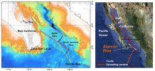
The petite dome — about 165 feet tall (50 meters) and 4,000 feet long by 1,640 feet wide (1,200 m by 500 m) — lies along the Alarcón Rise, a seafloor-spreading center. Tectonic forces are tearing the Earth's crust apart at the spreading center, creating a long rift where magma oozes toward the surface, cools and forms new ocean crust.

Circling the planet like baseball seams, seafloor-spreading centers (also called midocean ridges) produce copious amounts of basalt, a low-silica content lava rock that makes up the ocean crust. (Silica, or silicon dioxide, is the main component of quartz, one of the most common minerals on Earth.)

But samples from the newly discovered volcano are strangely rhyolite lava, and have the highest silica content (up to 77 percent) of any rocks collected from a midocean ridge, said Brian Dreyer, a geochemist at the University of California, Santa Cruz. The results were presented last week at the annual meeting of the American Geophysical Union.

Researchers with the Monterey Bay Aquarium Research Institute (MBARI) discovered the volcano this spring, during a three-month expedition to the Gulf of California, the warm stretch of water that separates Baja from mainland Mexico. A remote-control vehicle explored the volcano, which is 7,800 feet (2,375 m) below the surface, and brought samples back to the ship.

"When we picked up the rocks and got them back on the ship, we immediately noticed that they were very low density, and they were very light, glassy and gray. They were not the usual dark, black, shiny basalts," Dreyer told OurAmazingPlanet. "So we immediately knew that something was unusual."

The volcano is primarily rhyolite and a silicic lava called dacite, said MBARI geologist Jennifer Paduan. "To find this along a midocean ridge is a total surprise," she told OurAmazingPlanet.

Boulders and blocks the size of cars and small houses littered the steep slopes of the dome, the robot's video camera showed. The gravelly debris is made of lava that resembles the ragged surface of a'a (rough, rubbly or blocky lava). The flows would have been deposited via large, avalanchelike deposits, Paduan wrote on the expedition's blog. A few ridges were composed of very strange, steeply dipping, lineated flows very different from the pillow-style appearance of deep-sea basalt, she wrote.

The researchers don't yet know how the age of the volcano because their samples haven't finished undergoing the necessary tests. The dome is probably several thousand years old, MBARI geologist David Clague said in an email interview.

Of more concern is the evidence for explosive volcanism, which is typical of rhyolite volcanoes, Paduan said.

"It's only 100 kilometers [60 miles] from land. When the sun is setting, you can see Cabo," she said. Both the Baja Peninsula and mainland Mexico near Alarcón Rise have cities and luxury resorts. The Gulf of California is also home to endangered sea life.

Rhyolite lava carries more gas and volatiles (things that are likely to cause explosions) than basalt, and when magma meets water, it vaporizes instantly, driving an even more explosive eruption.

"There's definitely explosive deposits there, and that is of extreme concern, given that the ridge is so close to land and the tsunami potential of a big explosion there," Paduan said. "We don't know how explosive, and that is something we are definitely trying to figure out."

The researchers also found Pele's seaweed, or limu o pele, at another location on the 30-mile-long (50 km) ridge. These are little fragments of lava formed from explosive magmatic gas bubbles that implode when they hit cold seawater. "We did find evidence of mildly explosive eruptions on the ridge," Paduan said.

Rhyolites have been found on spreading centers, but only above hot spots, such as in Iceland and the Galapagos Islands, Dreyer said. Hot spots are plumes that bring magma to the surface from deep within Earth's mantle. There is no hot spot under the Alarcón Rise, he said.

Rhyolite lava typically occurs only on continents, such as in Mount St. Helen's growing dome in Washington. One possible explanation for the bizarre composition of the Alarcón volcano is that continental crust snuck into the molten rock below — the spreading center is young, and continental crust lies close by. But tests of different isotopes (versions of elements with differing numbers of neutrons in the cores) in the lava samples revealed no evidence of contamination by continental crust, Dreyer said.

Another discarded idea was that a cold spot underlying the ridge cooled and crystallized the magma chamber that fed the volcano, leaving only a high-silica melt behind. The team's current hypothesis is that the magma source had a high concentration of volatiles like water, sulfur and chlorine, maybe from an influx of seawater.

"It's a work in progress, but we have found some of the glassy volcanic debris surrounding this feature has water concentrations of up to eight percent, which is pretty unusual for a spreading center," Dreyer said.

The Alarcón Rise drifts apart at a relatively slow 2 inches (5 centimeters) a year. The segment is bounded by the Pescadero transform fault to the north and the Tamayo transform fault to the south, and is the northern extension of the East Pacific Rise. The vast majority of lava flows along the ridge are basalt. The rhyolite dome is about 5.5 miles (9 km) south of the Pescadero transform fault.
image taken from above site

It seems to me, earthquakes from today at the California's Gulf were at/or quite near Alarcon's Rise ...
 

Attachments

  • AlarconMap-600.jpg
    AlarconMap-600.jpg
    190.8 KB · Views: 239
... another one
_http://earthquake.usgs.gov/earthquakes/map said:
M 4.9 - 39km WSW of Topolobampo, Mexico
Time
2015-09-13 15:05:02 UTC
Location
25.514°N 109.433°W
Depth
10.0 km
 
2,9 by the Croatian Department of Geophysics just 4km under the capital Zagreb. Very intense short explosion like burst. Shook us well. Knock out few power stations, no damage or injuries reported. But this is 7th earthquake in the region in the last three weeks. We also had one last January similar in magnitude but a little bit to the east, which means that whole fault that city sits on is active. Strange thing is how this earthquake corresponds with first news about Syrian refugees arriving at Croatian eastern border, detouring Serbia-Hungary fenced border. Feeling a bit uneasy, like having a stone in my stomach.
 
just in on RT:

6.4 magnitude earthquake strikes near Indonesia’s Moluccas Islands

http://www.rt.com/news/line/

An earthquake of 6.4 magnitude struck on Wednesday near Indonesia’s Moluccas Islands, Reuters said, citing the US Geological Survey. No damage or casualties were immediately reported from the islands in the east of the archipelago.
 
Slovenia hit by an earthquake of magnitude 4.7 degrees, the epicenter was near the nuclear power plant, link:
https://translate.google.hr/translate?sl=hr&tl=en&js=y&prev=_t&hl=hr&ie=UTF-8&u=http%3A%2F%2Fwww.telegram.hr%2Fpolitika-kriminal%2Fsloveniju-pogodio-potres-magnitude-47-stupnjeva-epicentar-je-bio-30-ak-kilometara-od-zagreba%2F&edit-text=

In addition to earthquakes in Slovenia, the ground shook and this morning on the border of Croatian and Bosnia and Herzegovina, where he recorded an earthquake measuring 3 on the Richter scale with its epicenter at a depth of two kilometers.

Two earthquakes shook the morning and Albania. The first was at 7:20 pm magnitude 3.3 Richter scale at a depth of 10 kilometers, located 31 km east of Tirana. The second quake was felt in 7:26 pm, and was measuring 4.9 on the Richter scale. The epicenter of the earthquake was 34 kilometers east of Tirana, at a depth of 10 kilometers
 
casper said:
Two earthquakes shook the morning and Albania. The first was at 7:20 pm magnitude 3.3 Richter scale at a depth of 10 kilometers, located 31 km east of Tirana. The second quake was felt in 7:26 pm, and was measuring 4.9 on the Richter scale. The epicenter of the earthquake was 34 kilometers east of Tirana, at a depth of 10 kilometers


Earthquake was felt around 7:26 am this morning in several Macedonian cities.The epicenter of the tremor was in Albania:

https://translate.google.hr/translate?hl=hr&sl=mk&tl=en&u=http%3A%2F%2Fnetpress.com.mk%2Fzemjotres-utrovo-ja-strese-makedonija%2F&sandbox=1
 
casper said:
Slovenia hit by an earthquake of magnitude 4.7 degrees, the epicenter was near the nuclear power plant, link:
https://translate.google.hr/translate?sl=hr&tl=en&js=y&prev=_t&hl=hr&ie=UTF-8&u=http%3A%2F%2Fwww.telegram.hr%2Fpolitika-kriminal%2Fsloveniju-pogodio-potres-magnitude-47-stupnjeva-epicentar-je-bio-30-ak-kilometara-od-zagreba%2F&edit-text=

It shook us nicely for a few seconds, here near Slovenian border with Croatia.
At first I thought somebody's shaking my bed to get me out of it, and then when seeing no one around, realized Mother Earth was doing that. :)

It was reported that nuclear plant Krško is working normally (projected to sustain earthquakes up to magnitude 8), and that there was another smaller earthquake some 15 min afterwards, but not felt here.
http://net.hr/danas/svijet/ozbiljan-potres-u-sloveniji-udario-u-blizini-krskog-osjetio-se-do-zapresica/ (in Croatian).
 
Two weak tremors hit Zagreb day before Yesterday at 23:58 CET measuring 1.4, Located somewhere inside Zagreb's mountain. I didn't feel a thing, because I was already asleep. But my friend was wake and sad to me next day that although it was week it shook her place nicely, second tremor hit some 15min after. I suppose that it was shallow one, because all recent ones didn't go below 10km in depth. So all in all it doesn't look good since Zagreb lies on two fault lines and it seems that in the last few months there is notable rise in number of earthquakes in the vicinity.
 
BREAKING NEWS:

_http://en.dailypakistan.com.pk/headline/earthquake-jolts-parts-of-pakistan/

7.2 magnitude earthquake shakes parts of Pakistan, India

LAHORE (Staff Report)-Strong tremors of earthquake were felt in different parts of Pakistan and India, said media reports on Monday.

The earthquake mainly hit the northern parts of Pakistan including Islamabad, Sawat, Shangla, Abbotabad, Chitral, Charsada, Lower Dir, Upper Dir, Peshawar, Malakand, Gilgit and Chilas.

Indian media also reported that earthquake tremors were recorded in capital city of New Delhi and Indian occupied Kashmir.

According to US Geological Survey (USGS) the magnitude of earthquake was found to be 7.2 at Richter Scale centred 28km deep in earth and 109km west of Murghob area in Tajikistan.

There have been no reports of any losses to life or property so far.

This is the second strongest quake the 7.5 strong earthquake on October 26 – centred in the Hindu Kush, the 800km mountain range that stretches between central Afghanistan and northern Pakistan – leaving more than 300 people dead and over 2,000 injured.
 
From USGS

M 6.6 - 9km ENE of Tres Picos, (Chiapas) Mexico
2015-12-17 19:49:54 UTC
Location
15.888°N 93.446°W
Depth
97.8 km

From National Seismologic (Mexico) a second one
44 km al SUROESTE de TONALA, CHIS
2015-12-17
15:50:15
Latitud:15.75
Longitud:-93.99
Magnitud:4.3
Prf:88.0
 
Strong earthquake in the Aegean Sea
An earthquake measuring 5.2 on the Richter scale occurred at 11 am near the east, the Turkish Aegean coast of the Greek island of Dodekani
 
Papua New Guinea Rocked by 5.6-Magnitude Quake

http://sputniknews.com/asia/20151229/1032433681/papua-quake.html

A 5.6-magnitude earthquake struck Papua New Guinea, the US Geological Survey said Tuesday.

MOSCOW (Sputnik) – The quake was registered at 01:51 GMT.

The epicenter was located about 92 kilometers (57 miles) south of the town of Panguna at the depth of 47.2 kilometers.

There are currently no reports of damage or victims due to the earthquake.
 
Back
Top Bottom