Earthquakes around the world

Things are heating up in Iceland ?
1 Aug 2022

Apparently yesterday's earthquake was indeed a M 5.4 earthquake. German Vulkane.net writes following today:


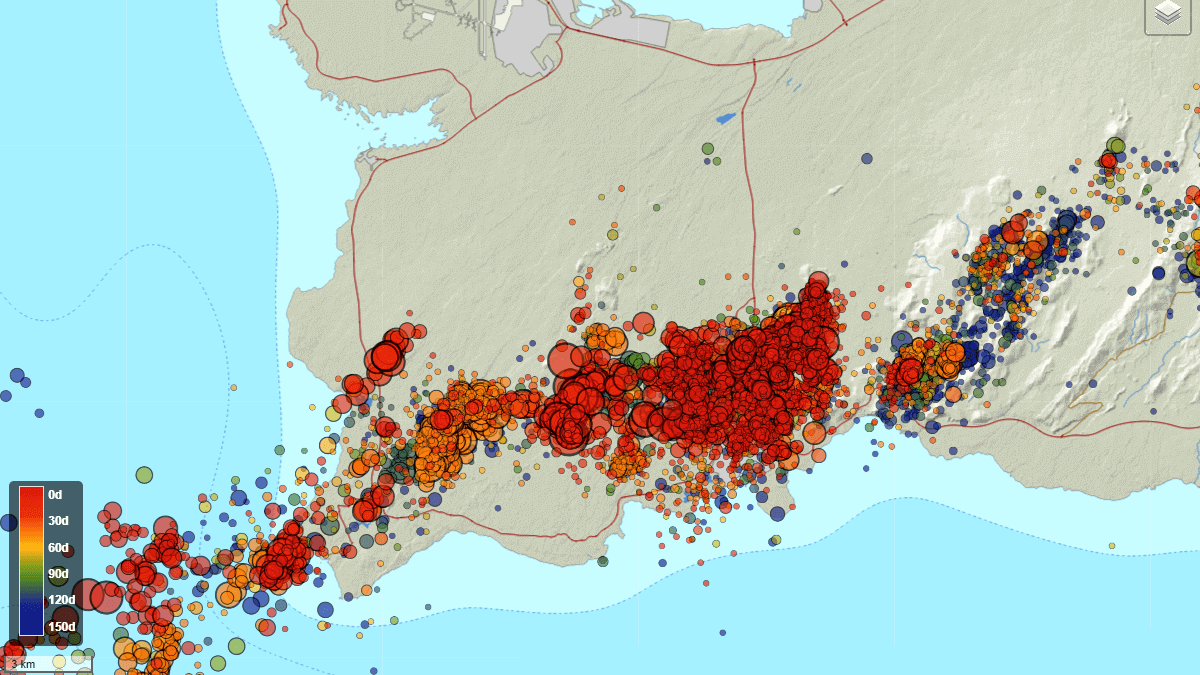
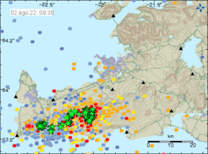
Swarm quake under Reykjanes on 01 Aug 2022
1 August 2022 by Marc Szeglat

ice1.jpg

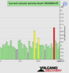
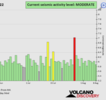
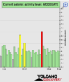
Earthquake activity under Reykjanes remains strong

After some confusion about the strong earthquake Mb 5.4 last night, I summarise the events of the last hours here again.

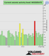
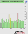
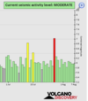
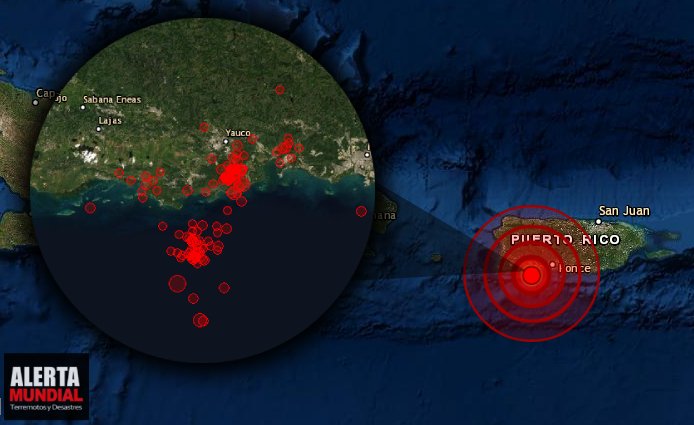
The swarm quake that began on Saturday morning continues and has lost none of its force. There are different accounts as far as the number of earthquakes is concerned. The IMO tables show 3172 tremors so far. 99 earthquakes had magnitudes from 3. According to an IMO statement, even more than 5,500 earthquakes were registered. This puts the swarm quake in the top range of all comparable events that I have been allowed to report on in Iceland so far. The strongest earthquake of the swarm so far manifested itself yesterday afternoon, at 17:47:59 UCT. It had a magnitude of 5.4. The earthquake focus was located at a depth of 1.9 km. The epicentre was located 3.0 km east-northeast of Grindavík.

gind.jpg

The earthquake was felt in large parts of southwest Iceland. Perception reports were received from the Snæfellsnes Peninsula. In Reykjavík, crockery clanged in the cupboards. In Grindavik itself, a water pipe was damaged. Items fell from shop shelves.

Automatic system failed

The automatic system of earthquake recording failed and a number of corrections were necessary until the final values were established. In the meantime, there were some error messages, which also indicated earthquakes with magnitudes greater than 3 at various locations in Iceland. Among them was a supposed M 4.4 quake under Katla. These quakes did not occur. Instead, there were several earthquakes in the magnitude 4 range at night, which occurred in the west of the Reykjanes Peninsula.

Magmatic activity under Fagradalsfjall

There seems to be no question that the earthquake swarm was triggered by magma intrusion in the area of the Fagradalsfjall volcano. This changed the stress field and triggered earthquakes in neighbouring fault systems. It is not yet clear to what extent ground uplift will occur as a result of the magma intrusion. The display of the automatic GPS measurements has been suspended. We will probably have to be patient until the IMO scientists come out with new verified data.

Since the beginning of the year, there has been significant ground uplift in a system that lies a good 10 km west of Fagradalsfjall. The situation was similar before the Fagradalsfjall eruption last year. Apparently, the magmatic activity has now shifted back to Fagradalsfjall and the risk of an imminent volcanic eruption is clearly increasing. On the livecam, rockfalls could be observed at the Fagradalsfjall cone, and steam was generated at the base of the cone.


END OF ARTICLE
 
It should be noted that in the past 48 hours the Earth seems to be vibrating. 2848 earthquakes below Magnitude 2 have occurred around the world.

▪︎Earthquake swarm Iceland region

M 4.6 - 8 km W of Álftanes, Iceland
2022-08-01 06:27:36 (UTC)
64.094°N 22.197°W. 10.0 km depth
USGS earthquake alert

M 4.4 - 11 km SE of Vogar, Iceland
2022-08-01 03:14:04 (UTC)
63.905°N 22.217°W. 10.0 km depth
USGS earthquake alert

M 4.2 - 1 km SE of Vogar, Iceland
2022-08-01 03:41:23 (UTC)
63.968°N 22.359°W. 10.0 km depth
USGS earthquake alert

▪︎Earthquake swarm. In less than 24 hours 1,200 quakes recorded in volcanic area on Ecuador-Colombia border

A report from the Geophysical Institute, says that the 1200 light earthquakes that are of volcanic tectonic character occurred in the area of the Chiles-Cerro Negro volcanic complex on Saturday, July 30, 2022.

The last study of the IG specifies that the superficial activity in the Chiles volcano is "very low" and with an "ascending" inclination, while the internal activity is "moderate" but also ascending.
Last Tuesday, the Geophysicist warned of an increase in the activity of the volcanic complex and asked the authorities of Ecuador and Colombia to consider a joint evacuation drill as a "preparedness measure".

According to the IG, an inflation phenomenon in the massif plus a fault considered "seismogenic" in the area, in addition to other conditions, could have acted as a "triggering mechanism" for the strong earthquake of magnitude 5.7 last Monday.

 
EARTHQUAKE REPORT PAST 24HRS

Based on the averages of all earthquakes during the last 24 hours we had a moderate seismic activity.
See Global seismic activity level chart

Reykjanes Península earthquake swarm update
A powerful earthquake swarm has begun on the Reykjanes Peninsula, Iceland. Nearly 4000 earthquakes have been detected in the first 24 hours, with the activity continuing at a strong pace. First data also shows tremor signals, indicating that the activity is likely due to magma movement below the ground.

This has prompted the officials to raise the alert level in the area. An eruption is likely, with the chance increasing steadily as the earthquake activity continues.

The image below shows the spreading tectonic plates and where the Mid-Atlantic Ridge passes through Iceland. It enters the southwest on the Reykjanes Peninsula, going to the east and turning north. Red triangles show the main central volcanoes.iceland-volcano-locations-and-tectonic-plates-separation-earthquake-swarm.png


▪︎M 5.2 - 15 km SW of Aitape, Papua New Guinea
2022-07-31 22:27:50 (UTC)
3.249°S 142.270°E. 33.9 km depth
USGS earthquake alert

▪︎M 5.3 - 68 km SSE of Akutan, Alaska
2022-08-01 00:36:41 (UTC)
53.568°N 165.361°W. 42.7 km depth
USGS earthquake alert

▪︎M 5.4 - 96 km WNW of Rabaul, Papua New Guinea
2022-08-01 01:43:49 (UTC)
3.798°S 151.388°E. 10.0 km depth
USGS earthquake alert

Quakes in the past 24 hours:

~3 quakes above magnitude 5
~50 quakes between magnitude 4 and 5
~146 quakes between magnitude 3 and 4
~434 quakes between magnitude 2 and 3
~1820 quakes below magnitude 2 that people normally don't feel.
~2453 quakes past 24 h. (2364 earthquakes in the 24 hours prior to this report) Estimated combined seismic energy released: 3.8 x 10¹³ joules (10.6 gigawatt hours, equivalent to 9085 tons of TNT or 0.6 atomic bombs!)

Volcanodiscovery earthquake report 24h
 

Attachments

  • chrome_screenshot_1659393447857.png
    chrome_screenshot_1659393447857.png
    329.9 KB · Views: 0
Iceland
2 Aug 2022

2 August 2022 by Marc Szeglat

Another earthquake Mb 5.0 shakes Iceland

220802_0930.jpg

The earthquake swarm under Reykjanes continues. There are phases in which the activity seems to weaken somewhat, only to intensify again shortly afterwards. We have seen such fluctuations in comparable events before. Last night around 11 pm, the activity increased again. Its focus shifted towards Lake Kleifarvatn. An earthquake of magnitude 5.0 occurred there tonight at 2:27 a.m. The quake was clearly felt in the southwest of the country. There were 2 other relatively strong earthquakes with magnitudes 4.8 and 4.7. A total of 15 events of magnitude 4 were recorded, extending from Mount Þorbjörn to Lake Kleifarvatn. IMO's tables show 3364 quakes for the last 48 hours.

As far as one can trust the GPS data, no ground uplift is registered, but a weak ground subsidence. Instead, there is divergence along the magmatic vein at Fagradalsfjall. Nevertheless, Icelandic researchers seem to agree that the seismic crisis is caused by the intrusion of a magmatic vein. The magma intrusion triggers the stronger earthquakes along the Reykjanes fault zones, but these are not volcanotectonic earthquakes. In a newspaper interview, geophysicist Páll Einarsson clarifies that the strong earthquakes are not directly caused by the rising magma and that these earthquakes do not allow any conclusions that a strong eruption must necessarily occur.

In fact, it is not yet clear at this point whether an eruption will actually occur. The magmatic duct can still get stuck in the earth's crust. But the longer the quakes continue, the greater the probability of an imminent volcanic eruption.

There is an increased risk of rockfalls on the Reykjanes Peninsula. A number of rockfalls have been reported in the region. IMO recommends being cautious on steep slopes and near sea cliffs and avoiding areas where rocks may fall.


END OF ARTICLE
 

5.7-magnitude quake hits Izu Islands, Japan region -- USGS

2022-08-04
HONG KONG, Aug. 4 (Xinhua) -- An earthquake with a magnitude of 5.7 jolted Izu Islands, Japan region at 03:39:46 GMT on Thursday, the U.S. Geological Survey said.

The epicenter, with a depth of 10.0 km, was initially determined to be at 32.6434 degrees north latitude and 142.4746 degrees east longitude.
 
EARTHQUAKE REPORT PAST 24HRS

Based on the averages of all earthquakes during the last 24 hours we had a moderate seismic activity. See Global seismic activity level chart

Strongest earthquake today M5.8 - Kermadec Islands, New Zealand.

▪︎M 5.1 - 42 km SSE of Kirakira, Solomon Islands
2022-08-05 02:37:20 (UTC)
10.776°S 162.129°E. 111.7 km depth
USGS earthquake alert

▪︎M 5.0 - South Sandwich Islands region
2022-08-05 06:39:13 (UTC)
58.786°S 25.202°W. 29.3 km depth
USGS earthquake alert

Quakes in the past 24 hours:

~3 quakes above magnitude 5
~29 quakes between magnitude 4 and 5
~85 quakes between magnitude 3 and 4
~223 quakes between magnitude 2 and 3
~499 quakes below magnitude 2 that people normally don't feel.
~839 quakes past 24 h. Estimated combined seismic energy released: 6.2 x 10¹³ joules (17.1 gigawatt hours, equivalent to 14736 tons of TNT or 0.9 atomic bombs!)

Volcanodiscovery earthquake report 24h
 

Attachments

  • chrome_screenshot_1659739695072.png
    chrome_screenshot_1659739695072.png
    318.4 KB · Views: 0
EARTHQUAKE REPORT

These are the global seismic activity data for the month of July.

Summary: 1 quake 7.0+, 7 quakes 6.0+, 143 quakes 5.0+, 1305 quakes 4.0+, 3860 quakes 3.0+, 8382 quakes 2.0+ (13698 total)

Magnitude 9+: none
Magnitude 8+: none
Magnitude 7+: 1 earthquake
Magnitude 6+: 7 earthquakes
Magnitude 5+: 143 earthquakes
Magnitude 4+: 1305 earthquakes
Magnitude 3+: 3860 earthquakes
Magnitude 2+: 8382 earthquakes

▪︎Total earthquakes July: 13698
Total seismic energy estimate: 5.3 x 10¹⁵ joules (1480 gigawatt hours, equivalent to 1.3 x 10⁶ tons of TNT or 79.6 atomic bombs)
Volcanodiscovery earthquake report July 2022

March continues to be the month with the highest seismic activity, however, July becomes the second most active month in 2022.

▪︎Total earthquakes Jun: 12,069
Total seismic energy estimate: 2.5 x 10¹⁵ joules (700 gigawatt hours, equivalent to 6 x 10⁵ tons of TNT or 37.6 atomic bombs!)

▪︎Total earthquakes May: 12456
Total seismic energy estimate: 9.1 x 10¹⁵ joules (2516 gigawatt hours, equivalent to 2.2 x 10⁶ tons of TNT or 135.3 atomic bombs!)

▪︎Total earthquakes April: 12750
Total seismic energy estimate: 3.2 x 10¹⁵ joules (876 gigawatt hours, equivalent to 7.5 x 10⁵ tons of TNT or 47.1 atomic bombs)

▪︎Total earthquakes March: 15065
Total seismic energy estimate: 1.4 x 10¹⁶ joules (4009 gigawatt hours, equivalent to 3.4 x 10⁶ tons of TNT or 215.6 atomic bombs!)

▪︎Total earthquakes February:11198
Total seismic energy estimate: 3.5 x 10¹⁵ joules (979 gigawatt hours, equivalent to 8.4 x 10⁵ tons of TNT or 52.6 atomic bombs!)

▪︎Total earthquakes January: 12435
Total seismic energy estimate: 5.8 x 10¹⁵ joules (1620 gigawatt hours, equivalent to 1.4 x 10⁶ tons of TNT or 87.1 atomic bombs)

▪︎Earthquakes Past 24 hours

Based on the averages of all earthquakes during the last 24 hours we had a moderate seismic activity. See Global seismic activity level chart

According to Volcanodiscovery data M5.7, 96 km northeast of Tarapaca, Amazonas, Colombia, on Saturday, Aug 6, 2022.
USGS record: M 4.5 - 29 km WSW of Necoclí, Colombia 01:03:47 (UTC) 8.327°N 77.039°W. 35.0 km depth
USGS earthquake alert

▪︎Two earthquakes hit Gulf of California

M 4.7 - 111 km NNE of Los Barriles, Mexico
2022-08-06 03:15:07 (UTC)
24.549°N 109.139°W. 10.0 km depth
USGS earthquake alert
M 4.7 - 68 km WSW of San Carlos, Mexico
2022-08-06 16:08:22 (UTC)
27.643°N 111.638°W. 10.0 km depth
USGS earthquake alert

Once again Puerto Rico is being hit by a seismic swarm. Sixteen earthquakes of magnitude between 2 and 4 have occurred in the last 24 hours. The highest magnitude quake was 4.2

M 4.2 - 11 km S of Guánica, Puerto Rico
2022-08-06 19:53:30 (UTC)
17.868°N 66.915°W. 13.0 km depth
USGS earthquake alert

Quakes in the past 24 hours:

~6 quakes above magnitude 5
~27 quakes between magnitude 4 and 5
~82 quakes between magnitude 3 and 4
~226 quakes between magnitude 2 and 3
~456 quakes below magnitude 2 that people normally don't feel.
~797 quakes past 24 h. (839 earthquakes in the 24 hours prior to this report) Estimated combined seismic energy released: 4.9 x 10¹³ joules (13.7 gigawatt hours, equivalent to 11818 tons of TNT or 0.7 atomic bombs!)

Volcanodiscovery earthquake report 24h

▪︎Earthquake Forecast


Attachments

  • chrome_screenshot_1659832079328.png
    chrome_screenshot_1659832079328.png
    315.8 KB · Views: 0
Last week saw 1 M7.0 in the Philippines and 2 low M6, both in Chile.
In the usual area, there was 1 out of 103 earthquakes worldwide equal to or greater than 4.5 and 1334 out of 1689 quakes of all sizes.
Percentage: 79.0%
Last week saw no earthquakes reaching M6.
In the usual area, there was 4 out of 100 earthquakes worldwide equal to or greater than 4.5 and 1495 out of 2045 quakes of all sizes.
Percentage: 73.1%
Earthquakes 7 days to August 7th  2022.gif
 
EARTHQUAKE REPORT PAST 24HRS

Based on the averages of all earthquakes during the last 24 hours we had a moderate seismic activity. See Global seismic activity level chart

▪︎Earthquake M6.1 on Shikotan Russia updated to M5.9 by USGS

▪︎M 5.0 - 138 km NE of Iquique, Chile
2022-08-07 02:41:15 (UTC)
19.333°S 69.213°W
104.6 km depth
USGS earthquake alert

▪︎M 5.1 - 126 km E of Madang, Papua New Guinea 2022-08-07 03:53:23 (UTC)
5.428°S 146.912°E. 228.8 km depth
USGS earthquake alert

Quakes in the past 24 hours:

~3 quakes above magnitude 5
~31 quakes between magnitude 4 and 5
~74 quakes between magnitude 3 and 4
~263 quakes between magnitude 2 and 3
~448 quakes below magnitude 2 that people normally don't feel.
~819 quakes past 24 h. (797 earthquakes in the 24 hours prior to this report) Estimated combined seismic energy released: 4.9 x 10¹³ joules (13.6 gigawatt hours, equivalent to 11659 tons of TNT or 0.7 atomic bombs!)
Volcanodiscovery earthquake report 24h
 

Attachments

  • chrome_screenshot_1659918722409.png
    chrome_screenshot_1659918722409.png
    318.2 KB · Views: 0
EARTHQUAKE REPORT PAST 24HRS

Based on the averages of all earthquakes during the last 24 hours: Current Seismic activity level is Moderate

▪︎Strongest earthquake today M 5.6 - 148 km SSW of Kokopo, Papua New Guinea
2022-08-08 05:37:17 (UTC)
5.525°S 151.631°E. 35.0 km depth
USGS earthquake alert

Earthquake swarm in Walker California. ▪︎Strongest earthquake M 4.5 - 8km NNE of Walker, CA 2022-08-08 20:44:14 (UTC) 38.582°N 119.446°W. 5.4 km depth
USGS earthquake alert
All earthquakes have been very shallow
▪︎M 2.6 - 8km NNE of Walker, CA
2022-08-08 20:53:25 (UTC)
38.581°N 119.455°W. 5.9 km depth

▪︎M 2.6 - 9km NNE of Walker, CA
2022-08-08 21:16:22 (UTC)
38.590°N 119.441°W. 4.3 km depth

▪︎M 2.5 - 9km NNE of Walker, CA
2022-08-08 22:19:04 (UTC)
38.590°N 119.460°W. 6.0 km depth

▪︎M 2.8 - 8km NNE of Walker, CA
2022-08-08 22:37:43 (UTC)
38.587°N 119.454°W. 5.7 km depth

▪︎M 2.7 - 9km NNE of Walker, CA
2022-08-08 22:39:15 (UTC)
38.592°N 119.459°W. 6.0 km depth

▪︎M 2.9 - 8km NNE of Walker, CA
2022-08-09 00:12:43 (UTC)
38.583°N 119.445°W. 7.2 km depth

▪︎M 3.1 - 8km NNE of Walker, CA
2022-08-09 00:33:28 (UTC)
38.582°N 119.451°W. 0.5 km depth

▪︎M 4.6 - 205 km W of Tofino, Canada
2022-08-08 07:38:56 (UTC)
48.978°N 128.710°W. 10.0 km depth
USGS earthquake alert

▪︎M 4.5 - 11 km SSW of Aígio, Greece
2022-08-08 14:45:22 (UTC)
38.148°N 22.054°E. 66.3 km depth
USGS earthquake alert

▪︎Quakes in the past 24 hours:

~5 quakes above magnitude 5
~25 quakes between magnitude 4 and 5
~94 quakes between magnitude 3 and 4
~256 quakes between magnitude 2 and 3
~420 quakes below magnitude 2 that people normally don't feel.
~800 quakes past 24 h. (819 earthquakes in the 24 hours prior to this report) Estimated combined seismic energy released: 3.7 x 10¹³ joules (10.3 gigawatt hours, equivalent to 8866 tons of TNT or 0.6 atomic bombs!)
Volcanodiscovery earthquake report 24h
 

Attachments

  • chrome_screenshot_1660007120577.png
    chrome_screenshot_1660007120577.png
    335.2 KB · Views: 0
EARTHQUAKE REPORT PAST 24HRS

More than 100 earthquakes shake Puerto Rico, from August 05 to 09, 2022, reports the United States Geological Survey (USGS).

More than 100 earthquakes have struck Puerto Rico and surrounding areas in recent days; fortunately, there is no tsunami threat at this time.

The latest quake occurred at 13:07 on August 9 and had a magnitude of 3.3 with a depth of 16 kilometers, the USGS said.

Of the 110 earthquakes that struck the area in the last week, 13 occurred in the last 24 hours, and most were concentrated in southwestern Puerto Rico, according to the USGS.

These earthquakes are not far from the epicenter of a strong earthquake that occurred in January 2020. That 6.4 created extensive damage in Puerto Rico, including widespread power failures across much of the island. A swarm of earthquakes began here in December 2019 and unrest has continued since then.

These earthquakes are occurring near the northern edge of the Caribbean Plate, a mostly oceanic tectonic plate that underlies Central America and the Caribbean Sea off the northern coast of South America. The Caribbean Plate is bordered by the North American Plate, the South American Plate, the Nazca Plate and the Cocos Plate. The edges of these plates host continuous seismic activity, including frequent earthquakes, occasional tsunamis and sometimes even volcanic eruptions. Fortunately, the earthquakes so far have been moderate enough not to create a tsunami. The strongest, a 3.1 that struck last night, was not strong enough to generate a tsunami threat for Puerto Rico, the Bahamas, the Caribbean or the U.S. East Coast.

▪︎ Strongest earthquake in Puerto Rico last 24h M 3.8 - 2 km SW of Indios, Puerto Rico
2022-08-09 13:12:04 (UTC)
17.977°N 66.837°W. 15.0 km depth
USGS earthquake alert

Most of the earthquakes that occurred in the last 24 hours in Puerto Rico had a magnitude between 2+ and 3+ degrees. Last August 6th two earthquakes, one M4.2 and the other M4.6 hit the island of Puerto Rico and have been the strongest so far.

Based on the averages of all earthquakes during the last 24 hours we had a moderate seismic activity.
Global seismic activity chart

▪︎Strongest earthquake M 5.7 - Off the coast of Aisen, Chile
2022-08-09 10:37:42 (UTC)
44.624°S 80.068°W. 10.0 km depth
USGS earthquake alert

▪︎M 5.1 - West Chile Rise
2022-08-09 17:53:32 (UTC)
41.354°S 87.666°W. 10.0 km depth
USGS earthquake alert

▪︎M 4.3 - 197 km WSW of Pistol River, Oregon
2022-08-09 14:40:47 (UTC)
41.871°N 126.718°W. 10.0 km depth
USGS earthquake alert

Quakes in the past 24 hours:

~5 quakes above magnitude 5
~29 quakes between magnitude 4 and 5
~85 quakes between magnitude 3 and 4
~243 quakes between magnitude 2 and 3
~492 quakes below magnitude 2 that people normally don't feel.
~854 quakes past 24 h. (800 earthquakes in the 24 hours prior to this report) Estimated combined seismic energy released: 5.8 x 10¹³ joules (16 gigawatt hours, equivalent to 13766 tons of TNT or 0.9 atomic bombs!)
Volcanodiscovery earthquake report 24h
 

Attachments

  • chrome_screenshot_1660082070437.png
    chrome_screenshot_1660082070437.png
    145.2 KB · Views: 0
EARTHQUAKE REPORT PAST 24HRS

Based on the averages of all earthquakes during the last 24 hours we had a moderate seismic activity. See Global seismic activity level chart

▪︎The seismic swarm in Puerto Rico has stopped. Only one minor earthquake was recorded: M 2.7 - 4 km SE of Las Marías, Puerto Rico 2022-08-10 16:33:52 (UTC)
18.221°N 66.965°W. 22.6 km depth

▪︎Strongest earthquake today M 5.2 - 30 km N of Isangel, Vanuatu
2022-08-10 06:59:26 (UTC)
19.263°S 169.285°E. 158.4 km depth
USGS earthquake alert

▪︎M 5.1 - 51 km SSE of Makubetsu, Japan
2022-08-10 15:52:58 (UTC)
44.957°N 142.113°E. 5.5 km depth
USGS earthquake alert

Quakes in the past 24 hours:

~3 quakes above magnitude 5
~32 quakes between magnitude 4 and 5
~95 quakes between magnitude 3 and 4
~281 quakes between magnitude 2 and 3
~440 quakes below magnitude 2 that people normally don't feel.
~851 quakes past 24 h. (854 earthquakes in the 24 hours prior to this report) Estimated combined seismic energy released: 2.4 x 10¹³ joules (6.76 gigawatt hours, equivalent to 5819 tons of TNT or 0.4 atomic bombs!)
Volcanodiscovery earthquake report 24h
 
EARTHQUAKE REPORT PAST 24HRS

Balloon fleet detects 7.3 magnitude earthquake from the stratosphere
A new paper just published in the Geophysical Research Letters reports the detection of a magnitude 7.3 earthquake by a fleet of balloons floating through the stratosphere above Indonesia's Flores Sea. Onboard infrasound sensors registered acoustic waves rippling upward from the sea surface below, proving that, here on Earth, balloons can be used as seismometers.

In the fall of 2021, the Centre National d’Etudes Spatiales (CNES) launched a fleet of 16 balloons from Mahé Island in the Seychelles archipelago. Unlike ordinary weather balloons, which explode in a matter of hours, these were "superpressure balloons," which can remain aloft for months. Stratospheric winds carried them over the Flores Sea.
quakemap_strip.jpg
Four balloons picked up the undersea quake on Dec. 14, 2021. Combining their signals, researchers pinpointed the epicenter within 300 km, the magnitude of the quake within 0.8 units, and its onset within 50 seconds. Furthermore, waveforms recorded by the infrasound sensors were detailed enough to sense structures in the Earth 100 km deep.

"Balloons could be used to cover ocean regions where conventional seismometers are not yet deployed," notes Garcia. "Another advantage: Balloons may be rapidly deployed just after a big quake for monitoring aftershocks."

The test flights have already unearthed a curiosity in South America. On Nov. 28, 2021, just one of the balloons detected a magnitude 7.5 earthquake in northern Peru. The infrasound frequency, 0.23 Hz, was higher than expected; for comparison, the Flores Sea quake registered a more typical 0.085–0.125 Hz. Garcia's team believes the high pitch may have been caused by a "ringing" of sediments in the Amazonian basin.

Sensing earthquakes from the stratosphere is relatively new. Researchers at Caltech and the Jet Propulsion Laboratory did it for the first time in July 2019. Garcia's study marks the first time an earthquake was detected by more than one balloon. It won't be the last.
SpaceWeather.com Earthquake ballons in the stratosphere

Based on the averages of all earthquakes during the last 24 hours we had a low seismic activity. See Global seismic activity level chart

▪︎M 5.0 - Kermadec Islands, New Zealand
2022-08-11 18:46:19 (UTC)
30.396°S 177.457°W. 38.9 km depth
USGS earthquake alert

Quakes in the past 24 hours:

~1 quake above magnitude 5
~23 quakes between magnitude 4 and 5
~85 quakes between magnitude 3 and 4
~256 quakes between magnitude 2 and 3
~487 quakes below magnitude 2 that people normally don't feel.
~852 quakes past 24 h. (851 earthquakes in the 24 hours prior to this report) Estimated combined seismic energy released: 1.1 x 10¹³ joules (3.11 gigawatt hours, equivalent to 2677 tons of TNT or 0.2 atomic bombs!)
Volcanodiscovery earthquake report 24h
 

Attachments

  • chrome_screenshot_1660254614943.png
    chrome_screenshot_1660254614943.png
    298.5 KB · Views: 0
Back
Top Bottom