EARTHQUAKE REPORT PAST 24HRS
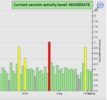
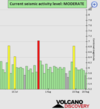
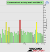
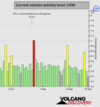
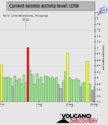
Based on the averages of all earthquakes during the last 24 hours we had a moderate seismic activity level. See Global seismic activity level chart
Quakes in the past 24 hours:
~5 quakes above magnitude 5
~26 quakes between magnitude 4 and 5
~73 quakes between magnitude 3 and 4
~206 quakes between magnitude 2 and 3
~463 quakes below magnitude 2 that people normally don't feel.
~773 quakes past 24 h. (751 earthquakes in the 24 hours prior to this report) Estimated combined seismic energy released: 4.8 x 10¹³ joules (13.4 gigawatt hours, equivalent to 11538 tons of TNT or 0.7 atomic bombs!)
Volcanodiscovery earthquake report 24h
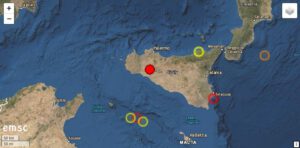
▪︎Strongest earthquake today M 5.4 - 118 km SSW of Tomohon, Indonesia
2022-08-18 07:46:27 (UTC)
0.340°N 124.375°E
166.5 km depth
USGS earthquake alert
▪︎M 5.3 - 19 km SSE of Machalí, Chile (see post #3824)
▪︎M 5.1 - 61 km ENE of Namie, Japan
2022-08-18 05:46:09 (UTC)
37.628°N 141.674°E
53.5 km depth
USGS earthquake alert
▪︎M 5.1 - southern Mid-Atlantic Ridge
2022-08-18 21:24:29 (UTC)
20.224°S 12.412°W
10.0 km depth
USGS earthquake alert
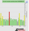
Based on the averages of all earthquakes during the last 24 hours we had a moderate seismic activity level. See Global seismic activity level chart
Quakes in the past 24 hours:
~5 quakes above magnitude 5
~26 quakes between magnitude 4 and 5
~73 quakes between magnitude 3 and 4
~206 quakes between magnitude 2 and 3
~463 quakes below magnitude 2 that people normally don't feel.
~773 quakes past 24 h. (751 earthquakes in the 24 hours prior to this report) Estimated combined seismic energy released: 4.8 x 10¹³ joules (13.4 gigawatt hours, equivalent to 11538 tons of TNT or 0.7 atomic bombs!)
Volcanodiscovery earthquake report 24h
▪︎Strongest earthquake today M 5.4 - 118 km SSW of Tomohon, Indonesia
2022-08-18 07:46:27 (UTC)
0.340°N 124.375°E
166.5 km depth
USGS earthquake alert
Data for the same earthquake reported by different agencies
Info: The more agencies report about the same quake and post similar data, the more confidence you can have in the data. It takes normally up to a few hours until earthquake parameters are calculated with near-optimum precision.| Mag. | Depth | Location | Source |
| 5.7 | 155 km | Indonesia: Di Laut 47 Km Tenggara Bolaang Uki | BMKG |
| 5.4 | 169 km | MINAHASA, SULAWESI, INDONESIA | EMSC |
| 5.4 | 167 km | Indonesia: Minahassa Peninsula, Sulawesi | RaspberryShake |
| 5.4 | 173 km | 118 Km SSW of Tomohon, Indonesia | GFZ |
| 5.5 | 173 km | Minahassa Peninsula, Sulawesi, Indonesia [Sea: Indonesia] | INGV |
| 5.4 | 167 km | Indonesia: Minahassa Peninsula, Sulawesi | USGS |
| 5.4 | 160 km | Indonesia: Minahassa Peninsula, Sulawesi | GeoAu |
| 5.2 | 178 km | Indonesia: Near Manado | RENASS |
▪︎M 5.3 - 19 km SSE of Machalí, Chile (see post #3824)
▪︎M 5.1 - 61 km ENE of Namie, Japan
2022-08-18 05:46:09 (UTC)
37.628°N 141.674°E
53.5 km depth
USGS earthquake alert
▪︎M 5.1 - southern Mid-Atlantic Ridge
2022-08-18 21:24:29 (UTC)
20.224°S 12.412°W
10.0 km depth
USGS earthquake alert