WORLDWIDE EARTHQUAKE REPORT NOVEMBER 18
An earthquake of magnitude 4.9 occurred 9 km west of Point MacKenzie, Alaska (pop: 529) The quake hit at a moderately shallow depth of 46 km beneath the epicenter on Thursday, November 17th at 03:03 pm local time. Several smaller aftershocks have been recorded in the last 24 hours.
● M 4.9 - 9 km W of Point MacKenzie, Alaska
2022-11-18 00:03:09 (UTC)
61.372°N 150.153°W. 45.9 km depth
USGS earthquake alert
M 4.1 - 19 km WSW of Salcha, Alaska
M 3.1 - 85 km SE of Chignik, Alaska
M 3.5 - 126 km SSE of Sand Point, Alaska
M 2.7 - 28 km WSW of Salcha, Alaska
M 2.5 - 30 km NNE of Pilot Point, Alaska
M 3.6 - 34 km WSW of Trapper Creek, Alaska
M 2.9 - 59 km WNW of Ninilchik, Alaska
M 2.7 - 37 km ESE of Port Heiden, Alaska
M 2.7 - 54 km SSW of Shungnak, Alaska
M 3.5 - 69 km ENE of Ugashik, Alaska
The latest M 3.0 - 233 km SE of Chiniak, Alaska at 23:07:37 UTC
Moderate mag. 4.5 earthquake in North Pacific Ocean, 121 mi west of Coos Bay, Coos County (pop: 16,200) Oregon, USA, on Friday, Nov 18, at 7:42 am local time.
● M 4.5 - 181 km W of Bandon, Oregon
2022-11-18 15:42:45 (UTC)
43.373°N 126.620°W 10.0 km depth
USGS earthquake alert
Major magnitude 6.9 earthquake in Indian Ocean, 216 km southwest of Benkulu, Bengkulu, Indonesia, on Friday, Nov 18, 2022 at 8:37 pm local time
The magnitude 6.9 earthquake in Indonesia occurred in the band indicated as a candidate for a strong seismic event.
●
Aftershock M5.4 - 211 km WSW of Bengkulu, Indonesia
2022-11-18 14:07:00 (UTC)
4.633°S 100.550°E. 10.0 km depth
USGS earthquake alert
● Earthquake Forecast
The Mediterranean region between Italy, Greece and Turkey is having light seismic activity. This is the latest earthquake recorded in the region:
● M4.3 earthquake - Eastern Mediterranean, 91 km southeast of Ierapetra, Lasithi, Crete, Greece, on Friday, Nov 18, 2022 at 7:14 pm local time (17:14:34 UTC) 34.389°N 26.618°E. 34.0 km depth
USGS earthquake alert
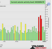
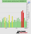
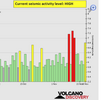
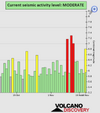
● Summary
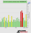
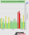
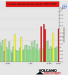
Seismic activity level has been at
high levels in the last 24 hours. This is the last chart posted by Volcanodiscovery 23:50 UTC on November 17
Global seismic activity level chart
~1 quake above magnitude 6
~5 quakes between magnitude 5 and 6
~35 quakes between magnitude 4 and 5
~91 quakes between magnitude 3 and 4
~214 quakes between magnitude 2 and 3
~456 quakes below magnitude 2 that people normally don't feel.
~802 earthquakes in the past 24h (858 earthquakes in the 24 hours prior to this report) Estimated combined seismic energy release: 2.5 x 10⁵ tons of TNT or 15.4 atomic bombs
Volcanodiscovery earthquake report 24h

 www.emsc-csem.org

 apnews.com