You are using an out of date browser. It may not display this or other websites correctly.
You should upgrade or use an alternative browser.
You should upgrade or use an alternative browser.
Earthquakes around the world
- Thread starter pescado
- Start date
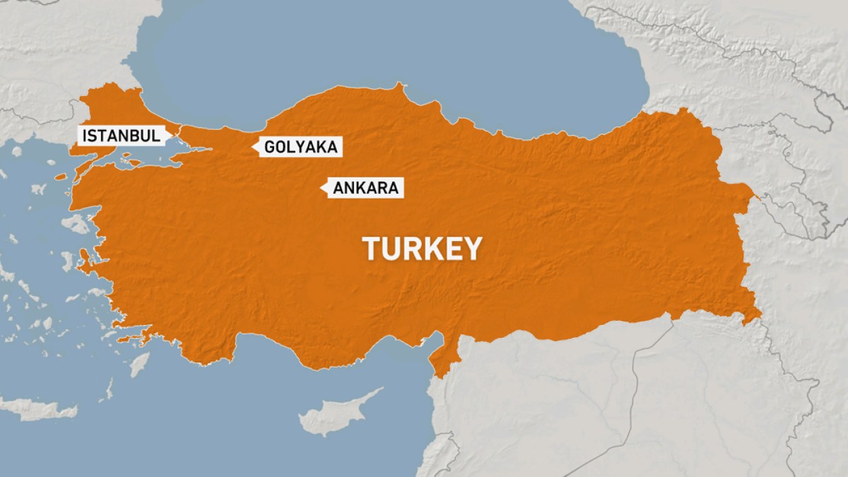
A magnitude 6.1 earthquake in Turkey near Düzce (pop. 57,700) The earthquake hit early morning on Wednesday, November 23rd, at 4:08 am local time at a shallow depth of 10 km. Dangerous ground shaking occurred with the potential to inflict moderate to heavy damage to buildings and other infrastructure.
M 6.1 - Western Turkey
2022-11-23 01:08:15 (UTC)
40.847°N 30.967°E. 10.0 km depth
USGS earthquake alert
M 6.1 - Western Turkey
2022-11-23 01:08:15 (UTC)
40.847°N 30.967°E. 10.0 km depth
USGS earthquake alert
WORLDWIDE EARTHQUAKE REPORT NOVEMBER 23
AFAD and media reports later updated the number of injured to 50.
Most of the injuries were sustained during the panic after the quake, including from jumping from balconies or windows. One of the injured was in a serious condition, Soylu said.

The quake struck at 4:08am (01:08 GMT) and Turkish media said it was also felt in Istanbul and the capital, Ankara.
Dozens of aftershocks were reported, including one of a magnitude 4.3.
 www.aljazeera.com
According to USGS an aftershock magnitude 4.5 hit Düzce at 06:50 am local time at very shallow depth of 10 km
M 4.5 - 16 km WSW of Düzce, Turkey
2022-11-23 03:50:58 (UTC)
40.802°N 30.975°E 10.0 km depth
USGS earthquake alert
Worst-case scenario, magnitude 6.0 earthquake is a precursor to a larger event
There is a period of five days after an atmospheric fluctuation is recorded for the occurrence of a major seismic event.
● M 5.0 - 18 km NNE of San Clemente, Chile
2022-11-23 08:53:12 (UTC)
35.389°S 71.386°W. 82.6 km depth
USGS earthquake alert
● M 5.2 - 185 km SSE of Katsuura, Japan
2022-11-23 16:52:23 (UTC)
33.727°N 141.390°E. 12.9 km depth
USGS earthquake alert
● M 5.1 - Norwegian Sea
2022-11-23 17:04:28 (UTC)
72.507°N 3.240°E. 10.0 km depth
USGS earthquake alert
● Earthquake Forecast: A convergence of critical planetary and lunar geometry on 21-22 November may trigger larger seismic activity around 23 November or with the next lunar peak, around 26 November. There is a slight possibility of a mega-thrust earthquake.
● Summary
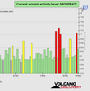
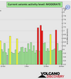
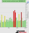
Seismic activity level has been at moderate levels in the last 24 hours. This is the last chart posted by Volcanodiscovery 00:40 UTC on November 23 Global seismic activity level chart
~1 quake above magnitude 6
~7 quakes between magnitude 5 and 6
~58 quakes between magnitude 4 and 5
~111 quakes between magnitude 3 and 4
~258 quakes between magnitude 2 and 3
~460 quakes below magnitude 2 that people normally don't feel.
~895 earthquakes in the past 24h (749 earthquakes in the 24 hours prior to this report) Estimated combined seismic energy release: 43450 tons of TNT or 2.7 atomic bombs
Volcanodiscovery earthquake report 24h
Injuries after magnitude 6.0 earthquake strikes western Turkey
Health minister Fahrettin Koca said on Twitter that 35 people in Duzce and nearby provinces had been injured.AFAD and media reports later updated the number of injured to 50.
Most of the injuries were sustained during the panic after the quake, including from jumping from balconies or windows. One of the injured was in a serious condition, Soylu said.
The quake struck at 4:08am (01:08 GMT) and Turkish media said it was also felt in Istanbul and the capital, Ankara.
Dozens of aftershocks were reported, including one of a magnitude 4.3.
Injuries after magnitude 6.0 earthquake strikes western Turkey
Authorities said dozens of people were injured, mostly in the panic that ensued after the quake.
According to USGS an aftershock magnitude 4.5 hit Düzce at 06:50 am local time at very shallow depth of 10 km
M 4.5 - 16 km WSW of Düzce, Turkey
2022-11-23 03:50:58 (UTC)
40.802°N 30.975°E 10.0 km depth
USGS earthquake alert
Worst-case scenario, magnitude 6.0 earthquake is a precursor to a larger event
There is a period of five days after an atmospheric fluctuation is recorded for the occurrence of a major seismic event.
● M 5.0 - 18 km NNE of San Clemente, Chile
2022-11-23 08:53:12 (UTC)
35.389°S 71.386°W. 82.6 km depth
USGS earthquake alert
● M 5.2 - 185 km SSE of Katsuura, Japan
2022-11-23 16:52:23 (UTC)
33.727°N 141.390°E. 12.9 km depth
USGS earthquake alert
● M 5.1 - Norwegian Sea
2022-11-23 17:04:28 (UTC)
72.507°N 3.240°E. 10.0 km depth
USGS earthquake alert
● Earthquake Forecast: A convergence of critical planetary and lunar geometry on 21-22 November may trigger larger seismic activity around 23 November or with the next lunar peak, around 26 November. There is a slight possibility of a mega-thrust earthquake.
● Summary
Seismic activity level has been at moderate levels in the last 24 hours. This is the last chart posted by Volcanodiscovery 00:40 UTC on November 23 Global seismic activity level chart
~1 quake above magnitude 6
~7 quakes between magnitude 5 and 6
~58 quakes between magnitude 4 and 5
~111 quakes between magnitude 3 and 4
~258 quakes between magnitude 2 and 3
~460 quakes below magnitude 2 that people normally don't feel.
~895 earthquakes in the past 24h (749 earthquakes in the 24 hours prior to this report) Estimated combined seismic energy release: 43450 tons of TNT or 2.7 atomic bombs
Volcanodiscovery earthquake report 24h
Attachments
WORLDWIDE EARTHQUAKE REPORT NOVEMBER 23
Southwest Asia and the South Pacific Ocean recorded M5+ earthquakes in the past 24 hours. The highest magnitude earthquake occurred 63 km southwest of Honiara, Solomon Islands, on Thursday, Nov 24, 2022 at 8:15 pm
● M 5.4 - 25 km SW of Malango, Solomon Islands
2022-11-24 09:15:25 (UTC)
9.828°S 159.532°E. 10.0 km depth
USGS earthquake alert
● M 5.1 - 100 km E of Hihifo, Tonga
2022-11-24 15:01:10 (UTC)
16.078°S 172.865°W. 10.0 km depth
USGS earthquake alert
● M 5.1 - Luzon, Philippines
2022-11-24 15:05:05 (UTC)
18.353°N 120.805°E. 39.9 km depth
USGS earthquake alert
● M 5.2 - 15 km SSE of Malango, Solomon Islands
2022-11-24 15:13:29 (UTC)
9.815°S 159.788°E. 23.1 km depth
USGS earthquake alert
● M 5.0 - 30 km WSW of Malango, Solomon Islands
2022-11-24 22:43:34 (UTC)9.754°S 159.450°E10.0 km depth
USGS earthquake alert
Earthquakes magnitude 4.5 and 4.9 shook the state of Texas. A M4.5 earthquake was felt 37km WSW of Mentone (pop. 19) located 23 miles from the epicenter and Pecos (pop. 9,500) 32 miles away, at 1:14 pm local time. A second earthquake magnitude 4.9 occurred five minutes later. Both earthquakes were very shallow.
● M 4.5 - 37 km WSW of Mentone, Texas
2022-11-24 19:14:19 (UTC)
31.629°N 103.982°W. 7.0 km depth
USGS earthquake alert
● M 4.9 - 38 km WSW of Mentone, Texas
2022-11-24 19:19:28 (UTC)
31.622°N 103.998°W. 7.9 km depth
USGS earthquake alert
● Earthquake Forecast. An atmospheric fluctuation was recorded. We will see what happens in the next 5 days for the regions marked in the purple band.
● Summary
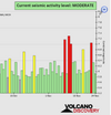
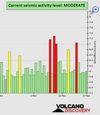
Seismic activity level has been at moderate levels in the last 24 hours. This is the last chart posted by Volcanodiscovery 00:50 UTC on November 23 Global seismic activity level chart
~7 quakes above magnitude 5
~31 quakes between magnitude 4 and 5
~99 quakes between magnitude 3 and 4
~211 quakes between magnitude 2 and 3
~432 quakes below magnitude 2 that people normally don't feel.
~780 earthquakes in the past 24h (895 earthquakes in the 24 hours prior to this report) Estimated combined seismic energy release: 8480 tons of TNT or 0.5 atomic bombs.
Volcanodiscovery earthquake report 24h
Southwest Asia and the South Pacific Ocean recorded M5+ earthquakes in the past 24 hours. The highest magnitude earthquake occurred 63 km southwest of Honiara, Solomon Islands, on Thursday, Nov 24, 2022 at 8:15 pm
● M 5.4 - 25 km SW of Malango, Solomon Islands
2022-11-24 09:15:25 (UTC)
9.828°S 159.532°E. 10.0 km depth
USGS earthquake alert
● M 5.1 - 100 km E of Hihifo, Tonga
2022-11-24 15:01:10 (UTC)
16.078°S 172.865°W. 10.0 km depth
USGS earthquake alert
● M 5.1 - Luzon, Philippines
2022-11-24 15:05:05 (UTC)
18.353°N 120.805°E. 39.9 km depth
USGS earthquake alert
● M 5.2 - 15 km SSE of Malango, Solomon Islands
2022-11-24 15:13:29 (UTC)
9.815°S 159.788°E. 23.1 km depth
USGS earthquake alert
● M 5.0 - 30 km WSW of Malango, Solomon Islands
2022-11-24 22:43:34 (UTC)9.754°S 159.450°E10.0 km depth
USGS earthquake alert
Earthquakes magnitude 4.5 and 4.9 shook the state of Texas. A M4.5 earthquake was felt 37km WSW of Mentone (pop. 19) located 23 miles from the epicenter and Pecos (pop. 9,500) 32 miles away, at 1:14 pm local time. A second earthquake magnitude 4.9 occurred five minutes later. Both earthquakes were very shallow.
● M 4.5 - 37 km WSW of Mentone, Texas
2022-11-24 19:14:19 (UTC)
31.629°N 103.982°W. 7.0 km depth
USGS earthquake alert
● M 4.9 - 38 km WSW of Mentone, Texas
2022-11-24 19:19:28 (UTC)
31.622°N 103.998°W. 7.9 km depth
USGS earthquake alert
● Earthquake Forecast. An atmospheric fluctuation was recorded. We will see what happens in the next 5 days for the regions marked in the purple band.
● Summary
Seismic activity level has been at moderate levels in the last 24 hours. This is the last chart posted by Volcanodiscovery 00:50 UTC on November 23 Global seismic activity level chart
~7 quakes above magnitude 5
~31 quakes between magnitude 4 and 5
~99 quakes between magnitude 3 and 4
~211 quakes between magnitude 2 and 3
~432 quakes below magnitude 2 that people normally don't feel.
~780 earthquakes in the past 24h (895 earthquakes in the 24 hours prior to this report) Estimated combined seismic energy release: 8480 tons of TNT or 0.5 atomic bombs.
Volcanodiscovery earthquake report 24h
Attachments
M 5.7 - 13 km SSE of Malango, Solomon Islands
2022-11-25
Solomon Islands: A magnitude-5.7 offshore earthquake occurs off the coast of Guadalcanal Island Nov. 26
A magnitude-5.7 earthquake occurs southeast of Guadalcanal Island, Solomon Islands, at around 00:46 Nov. 26. No immediate reports of damage.
 crisis24.garda.com
WORLDWIDE EARTHQUAKE REPORT NOVEMBER 25
Seismic activity throughout the Western Pacific. The Solomon Islands continue to be the focus of attention. Strong magnitude 5.7 earthquake occurred 45 km southwest of Honiara (pop. 56,300) and 13 km SSE of Malango (pop: 10,500) Solomon Islands at 12:46 am local time. Gallego is the nearest volcano, however, this volcano has been dormant. It is believed that the last eruption of the Gallego volcano was 2000 years ago.
Early at 12:28 am local time a very deep earthquake M5.0 occurred in the South Pacific Ocean, Fiji. There are no human populations in close proximity to the epicenter.
M 5.0 - Kermadec Islands region
2022-11-25 03:13:59 (UTC)
30.999°S 179.143°W. 10.0 km depth
USGS earthquake alert
● M 5.0 - 278 km E of Levuka, Fiji
2022-11-25 11:28:13 (UTC)
18.227°S 178.056°W. 539.3 km depth
USGS earthquake alert
● M 5.1 - 47 km SE of Malango, Solomon Islands
2022-11-25 13:24:47 (UTC)
9.966°S 160.055°E. 9.9 km depth
USGS earthquake alert
● M 5.7 - Solomon Islands
2022-11-25 13:46:51 (UTC)
9.802°S 159.775°E. 10.0 km depth
USGS earthquake alert
● M 5.0 - South Sandwich Islands region
2022-11-25 23:09:38 (UTC)
55.960°S 27.724°W. 11.5 km depth
USGS earthquake alert
● M 5.0 - 94 km S of Ust’-Kamchatsk Staryy, Russia
2022-11-25 23:37:44 (UTC)
55.376°N 162.476°E. 10.0 km depth
USGS earthquake alert
A seismic swarm was recorded in the Alaskan region. The highest magnitude quake was 4.3 Bering Sea, 121 mi west of Adak (pop. 332) , Aleutians West.
●M 4.3 - 195 km WSW of Adak, Alaska
2022-11-25 07:58:48 (UTC)
51.332°N 179.314°W. 37.1 km depth
USGS earthquake alert
M 3.8 - 22 km S of Atka, Alaska
M 2.7 - 109 km SSW of Kaktovik, Alaska
M 2.6 - 52 km SE of Cantwell, Alaska
M 2.7 - 73 km SE of Akhiok, Alaska
M 3.1 - 45 km NE of Livengood, Alaska
M 2.6 - 20 km E of Nikiski, Alaska
M 2.7 - 54 km S of Kobuk, Alaska
Latest quakes in Alaska and the Aleutian Islands in the past 24 hours on Saturday, November 26, 2022
1 quake above magnitude 4
2 quakes between magnitude 3 and 4
15 quakes between magnitude 2 and 3
29 quakes below magnitude 2 that people normally don't feel.

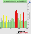
● Summary
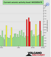
Seismic activity level has been at moderate levels in the last 24 hours. This is the last chart posted by Volcanodiscovery 02:40 UTC on November 23 Global seismic activity level chart
~6 quakes above magnitude 5
~34 quakes between magnitude 4 and 5
~103 quakes between magnitude 3 and 4
~224 quakes between magnitude 2 and 3
~449 quakes below magnitude 2 that people normally don't feel.
~816 earthquakes in the past 24h (780 earthquakes in the 24 hours prior to this report) Estimated combined seismic energy release: 10465 tons of TNT or 0.7 atomic bombs
Volcanodiscovery earthquake report 24h
Seismic activity throughout the Western Pacific. The Solomon Islands continue to be the focus of attention. Strong magnitude 5.7 earthquake occurred 45 km southwest of Honiara (pop. 56,300) and 13 km SSE of Malango (pop: 10,500) Solomon Islands at 12:46 am local time. Gallego is the nearest volcano, however, this volcano has been dormant. It is believed that the last eruption of the Gallego volcano was 2000 years ago.
Early at 12:28 am local time a very deep earthquake M5.0 occurred in the South Pacific Ocean, Fiji. There are no human populations in close proximity to the epicenter.
M 5.0 - Kermadec Islands region
2022-11-25 03:13:59 (UTC)
30.999°S 179.143°W. 10.0 km depth
USGS earthquake alert
● M 5.0 - 278 km E of Levuka, Fiji
2022-11-25 11:28:13 (UTC)
18.227°S 178.056°W. 539.3 km depth
USGS earthquake alert
● M 5.1 - 47 km SE of Malango, Solomon Islands
2022-11-25 13:24:47 (UTC)
9.966°S 160.055°E. 9.9 km depth
USGS earthquake alert
● M 5.7 - Solomon Islands
2022-11-25 13:46:51 (UTC)
9.802°S 159.775°E. 10.0 km depth
USGS earthquake alert
● M 5.0 - South Sandwich Islands region
2022-11-25 23:09:38 (UTC)
55.960°S 27.724°W. 11.5 km depth
USGS earthquake alert
● M 5.0 - 94 km S of Ust’-Kamchatsk Staryy, Russia
2022-11-25 23:37:44 (UTC)
55.376°N 162.476°E. 10.0 km depth
USGS earthquake alert
A seismic swarm was recorded in the Alaskan region. The highest magnitude quake was 4.3 Bering Sea, 121 mi west of Adak (pop. 332) , Aleutians West.
●M 4.3 - 195 km WSW of Adak, Alaska
2022-11-25 07:58:48 (UTC)
51.332°N 179.314°W. 37.1 km depth
USGS earthquake alert
M 3.8 - 22 km S of Atka, Alaska
M 2.7 - 109 km SSW of Kaktovik, Alaska
M 2.6 - 52 km SE of Cantwell, Alaska
M 2.7 - 73 km SE of Akhiok, Alaska
M 3.1 - 45 km NE of Livengood, Alaska
M 2.6 - 20 km E of Nikiski, Alaska
M 2.7 - 54 km S of Kobuk, Alaska
Latest quakes in Alaska and the Aleutian Islands in the past 24 hours on Saturday, November 26, 2022
1 quake above magnitude 4
2 quakes between magnitude 3 and 4
15 quakes between magnitude 2 and 3
29 quakes below magnitude 2 that people normally don't feel.
● Summary
Seismic activity level has been at moderate levels in the last 24 hours. This is the last chart posted by Volcanodiscovery 02:40 UTC on November 23 Global seismic activity level chart
~6 quakes above magnitude 5
~34 quakes between magnitude 4 and 5
~103 quakes between magnitude 3 and 4
~224 quakes between magnitude 2 and 3
~449 quakes below magnitude 2 that people normally don't feel.
~816 earthquakes in the past 24h (780 earthquakes in the 24 hours prior to this report) Estimated combined seismic energy release: 10465 tons of TNT or 0.7 atomic bombs
Volcanodiscovery earthquake report 24h
Attachments
WORLDWIDE EARTHQUAKE REPORT NOVEMBER 26
Northern Mariana Islands was shaken near Agrihan Village (pop. 20) Northern Islands, by an earthquake of magnitude 5.6 The earthquake hit at a shallow depth of 18.7 km beneath the epicenter near Agrihan Village, in the afternoon on Saturday, November 26th, at 4:05 pm local time. An aftershock of the earthquake occurred ten minutes later with a magnitude 5.2.
● M 5.6 - Pagan region, Northern Mariana Islands
2022-11-26 06:05:35 (UTC)
18.711°N 146.963°E. 18.1 km depth
USGS earthquake alert
● M 5.2 - Mariana Islands region
2022-11-26 06:15:23 (UTC)
18.714°N 147.049°E. 24.2 km depth
USGS earthquake alert
A shallow magnitude 5.1 earthquake was reported early morning near Hualien City, Hualien (pop. 350,500) Taiwan.The earthquake hit on Sunday, November 27th, at 01:38 am local time at a moderately shallow depth of 39.1 km
● M 5.1 - 19 km SSE of Hualien City, Taiwan
2022-11-26 17:38:03 (UTC)
23.815°N 121.679°E. 39.1 km depth
USGS earthquake alert
● M 5.0 - 146 km SSW of Severo-Kuril’sk, Russia
2022-11-26 18:44:06 (UTC)
49.401°N 155.606°E. 67.8 km depth
USGS earthquake alert
Moderate mag. 5.1 earthquake - Banda Sea, Indonesia, on Sunday, Nov 27, at 7:39 am local time
● M 5.1 - 249 km W of Tual, Indonesia
2022-11-26 22:39:20 (UTC)
5.836°S 130.508°E. 106.4 km depth
USGS earthquake alert
● Summary
Seismic activity level has been at moderate levels in the last 24 hours. This is the last chart posted by Volcanodiscovery 00:30 UTC on November 26 Global seismic activity level chart
~5 quakes above magnitude 5
~44 quakes between magnitude 4 and 5
~63 quakes between magnitude 3 and 4
~237 quakes between magnitude 2 and 3
~347 quakes below magnitude 2 that people normally don't feel.
~696 earthquakes in the past 24h (816 earthquakes in the 24 hours prior to this report) Estimated combined seismic energy release: 10452 tons of TNT or 0.7 atomic bombs
Volcanodiscovery earthquake report 24h
Attachments
Olivierlejardinier
Dagobah Resident
● M 5.0 - 146 km SSW of Severo-Kuril’sk, Russia
Magnitude 5.9 Earthquake Registered Near Russia's Kuril Islands -
PETROPAVLOVSK-KAMCHATSKIY (UrduPoint News / Sputnik - 27th November, 2022) KAMCHATSKIY, November 27 (Sputnik) - A massive 5.9 magnitude earthquake was registered on Sunday in the seismically active area of Russia's Kuril Islands, the geophysical service of the Russian academy of Sciences said.The earthquake took place at 16:59 local time (04:59 GMT). The epicenter was located 144 kilometers (89.
5 miles) from the town of Severo-Kurilsk at a depth of 73 kilometers.
There is no information about any victims or damage caused by the earthquake. No tsunami alert has been declared.
The Kuril Islands are located in a seismically active zone known as the Ring of Fire, which is regularly affected by powerful earthquakes. On November 5, 1952, a 9.0 magnitude earthquake triggered a huge tsunami that devastated the town of Severo-Kurilsk, leaving over 2,300 people killed.

Last week saw 3 M6 and 1 M7, being a M7.0 in the Solomon Islands.Last week saw 3 M6, the largest being a M6.9 in Indonesia.
In the usual area, there were 3 out of 97 earthquakes equal to or greater than 4.5 worldwide and 1763 out of 2196 quakes of all sizes.
Percentage: 80.3%
In the usual area, there were 9 out of 138 earthquakes equal to or greater than 4.5 worldwide and 1249 out of 1703 quakes of all sizes.
Percentage: 73.3%
WORLDWIDE EARTHQUAKE REPORT NOVEMBER 27
The earthquake M5.9 near Kuril Islands was downgraded to M5.4 by various seismological agencies.
Strong magnitude 5.6 earthquake in South Pacific Ocean, Chile, on Saturday, Nov 26, 2022 at 7:50 pm local time
● M 5.6 - Easter Island region
2022-11-27 02:50:52 (UTC)
24.925°S 112.241°W. 10.0 km depth
USGS earthquake alert
A magnitude 5.0 earthquake hit 31 km (19 mi) SW of Masachapa (pop: 5,000), Nicaragua. The earthquake occurred at a moderately shallow depth of 53 km beneath the epicenter early morning on Sunday, November 27th, at 2:32 am local time. EMSC recorded the quake as 5.4 but it was adjusted to 5.0 later
M 5.0 - 31 km SW of Masachapa, Nicaragua
2022-11-27 08:32:37 (UTC)
11.620°N 86.746°W. 53.0 km depth
USGS earthquake alert
Other magnitude 5.0 earthquakes
M 5.0 - Tonga region
M 5.0 - Vanuatu
M 5.1 - 28 km ENE of Cortes, Philippines
M 5.1 - Kermadec Islands region (04:44 UTC)
M 5.1 - Kermadec Islands region (10:32 UTC)
M 5.1 - Pacific-Antarctic Ridge
M 5.0 - Mariana Islands region
● Summary
Seismic activity level has been at moderate levels in the last 24 hours. This is the last chart posted by Volcanodiscovery 00:30 UTC on November 26 Global seismic activity level chart
~10 quakes above magnitude 5
~35 quakes between magnitude 4 and 5
~82 quakes between magnitude 3 and 4
~232 quakes between magnitude 2 and 3
~363 quakes below magnitude 2 that people normally don't feel.
~722 earthquakes in the past 24h (696 earthquakes in the 24 hours prior to this report) Estimated combined seismic energy release: 13445 tons of TNT or 0.8 atomic bombs
Volcanodiscovery earthquake report 24h
Magnitude 5.9 Earthquake Registered Near Russia's Kuril Islands -
The earthquake M5.9 near Kuril Islands was downgraded to M5.4 by various seismological agencies.
| Mag. | Depth | Location | Source |
| 5.4 | 81 km | 137 Km SSW of Severo-Kuril’sk, Russia | USGS |
| 5.4 | 60 km | Russia: KURIL ISLANDS | EMSC |
| 5.4 | 81 km | Russia: Kuril Islands | RaspberryShake |
| 5.4 | 91 km | Russia: Near Petropavlovsk Kamchatskiy | RENASS |
| 5.2 | 72 km | Russia: Kuril Islands | GFZ |
| 5.4 | 10 km | Russia: Kuril Islands | IRIS |
| 5.4 | 82 km | Russia: Kuril Islands | GeoAu |
Strong magnitude 5.6 earthquake in South Pacific Ocean, Chile, on Saturday, Nov 26, 2022 at 7:50 pm local time
● M 5.6 - Easter Island region
2022-11-27 02:50:52 (UTC)
24.925°S 112.241°W. 10.0 km depth
USGS earthquake alert
A magnitude 5.0 earthquake hit 31 km (19 mi) SW of Masachapa (pop: 5,000), Nicaragua. The earthquake occurred at a moderately shallow depth of 53 km beneath the epicenter early morning on Sunday, November 27th, at 2:32 am local time. EMSC recorded the quake as 5.4 but it was adjusted to 5.0 later
M 5.0 - 31 km SW of Masachapa, Nicaragua
2022-11-27 08:32:37 (UTC)
11.620°N 86.746°W. 53.0 km depth
USGS earthquake alert
Other magnitude 5.0 earthquakes
M 5.0 - Tonga region
M 5.0 - Vanuatu
M 5.1 - 28 km ENE of Cortes, Philippines
M 5.1 - Kermadec Islands region (04:44 UTC)
M 5.1 - Kermadec Islands region (10:32 UTC)
M 5.1 - Pacific-Antarctic Ridge
M 5.0 - Mariana Islands region
● Summary
Seismic activity level has been at moderate levels in the last 24 hours. This is the last chart posted by Volcanodiscovery 00:30 UTC on November 26 Global seismic activity level chart
~10 quakes above magnitude 5
~35 quakes between magnitude 4 and 5
~82 quakes between magnitude 3 and 4
~232 quakes between magnitude 2 and 3
~363 quakes below magnitude 2 that people normally don't feel.
~722 earthquakes in the past 24h (696 earthquakes in the 24 hours prior to this report) Estimated combined seismic energy release: 13445 tons of TNT or 0.8 atomic bombs
Volcanodiscovery earthquake report 24h
Attachments
WORLDWIDE EARTHQUAKE REPORT NOVEMBER 28
The past 24 hours have been characterized by minor seismic swarms around Mauna Loa volcano. The highest magnitude earthquakes so far have been of magnitude 4.2 and 4.0.
~2 quakes above magnitude 4
~14 quakes between magnitude 3 and 4
~96 quakes between magnitude 2 and 3
~32 quakes below magnitude 2 that people normally don't feel.
Mauna Loa earthquakes past 24h
● M 4.2 - 27 km E of Honaunau-Napoopoo, Hawaii
2022-11-28 08:56:25 (UTC)
19.471°N 155.601°W. -1.2 km depth
USGS earthquake alert
● M 4.0 - Island of Hawaii, Hawaii
2022-11-28 09:51:36 (UTC)
19.479°N 155.580°W. -3.0 km depth
USGS earthquake alert
As we can see both earthquakes show negative depth. Negative depth means "above" sea level.
Strong mag. 5.9 earthquake in North Atlantic Ocean, 275 km southwest of Lagens, Portugal (pop. 3600), on Monday, November 28, at 12:51 am local time at a shallow depth of 10km
● M 5.9 - 274 km SSW of Lajes das Flores, Portugal
2022-11-28 02:51:23 (UTC)
37.098°N 32.397°W. 10.0 km depth
USGS earthquake alert
● M 5.0 - Kermadec Islands region
2022-11-28 02:56:38 (UTC)
31.005°S 179.095°W 10.0 km depth
USGS earthquake alert
● M 5.1 - 106 km ENE of Amahai, Indonesia
2022-11-28 22:26:40 (UTC)
2.933°S 129.793°E. 10.0 km depth
USGS earthquake alert
● Summary
Seismic activity level has been at moderate levels in the last 24 hours. This is the last chart posted by Volcanodiscovery 01:10 UTC on November 28 Global seismic activity level chart
~3 quakes above magnitude 5
~33 quakes between magnitude 4 and 5
~102 quakes between magnitude 3 and 4
~294 quakes between magnitude 2 and 3
~506 quakes below magnitude 2 that people normally don't feel.
~938 earthquakes in the past 24h (722 earthquakes in the 24 hours prior to this report) Estimated combined seismic energy release: 16521 tons of TNT or 1 atomic bombs
Volcanodiscovery earthquake report 24h
An eruption started at Mauna Loa
28 November 2022 • by Marc Szeglat
State: USA | Location: 19.47, -155.59 | Activity: Lava flow
The earthquake activity this morning (vnet reported) at Mauna Loa was an indicator of the beginning of an eruption.
The past 24 hours have been characterized by minor seismic swarms around Mauna Loa volcano. The highest magnitude earthquakes so far have been of magnitude 4.2 and 4.0.
~2 quakes above magnitude 4
~14 quakes between magnitude 3 and 4
~96 quakes between magnitude 2 and 3
~32 quakes below magnitude 2 that people normally don't feel.
Mauna Loa earthquakes past 24h
● M 4.2 - 27 km E of Honaunau-Napoopoo, Hawaii
2022-11-28 08:56:25 (UTC)
19.471°N 155.601°W. -1.2 km depth
USGS earthquake alert
● M 4.0 - Island of Hawaii, Hawaii
2022-11-28 09:51:36 (UTC)
19.479°N 155.580°W. -3.0 km depth
USGS earthquake alert
As we can see both earthquakes show negative depth. Negative depth means "above" sea level.
Strong mag. 5.9 earthquake in North Atlantic Ocean, 275 km southwest of Lagens, Portugal (pop. 3600), on Monday, November 28, at 12:51 am local time at a shallow depth of 10km
● M 5.9 - 274 km SSW of Lajes das Flores, Portugal
2022-11-28 02:51:23 (UTC)
37.098°N 32.397°W. 10.0 km depth
USGS earthquake alert
● M 5.0 - Kermadec Islands region
2022-11-28 02:56:38 (UTC)
31.005°S 179.095°W 10.0 km depth
USGS earthquake alert
● M 5.1 - 106 km ENE of Amahai, Indonesia
2022-11-28 22:26:40 (UTC)
2.933°S 129.793°E. 10.0 km depth
USGS earthquake alert
● Summary
Seismic activity level has been at moderate levels in the last 24 hours. This is the last chart posted by Volcanodiscovery 01:10 UTC on November 28 Global seismic activity level chart
~3 quakes above magnitude 5
~33 quakes between magnitude 4 and 5
~102 quakes between magnitude 3 and 4
~294 quakes between magnitude 2 and 3
~506 quakes below magnitude 2 that people normally don't feel.
~938 earthquakes in the past 24h (722 earthquakes in the 24 hours prior to this report) Estimated combined seismic energy release: 16521 tons of TNT or 1 atomic bombs
Volcanodiscovery earthquake report 24h
Attachments
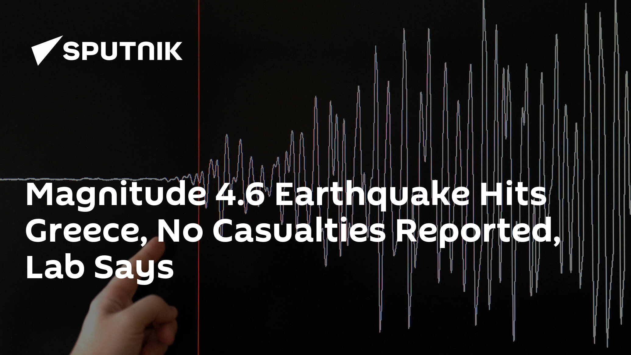
Magnitude 4.6 Earthquake Hits Greece, No Casualties Reported, Lab Says
ATHENS (Sputnik) - A massive 4.6 magnitude earthquake hit Greece on Tuesday, with tremors reaching Athens, the Seismological Laboratory of the University of Athens said.
 sputniknews.com
WORLDWIDE EARTHQUAKE REPORT NOVEMBER 29
A series of foreshocks struck northeastern Athens Greece prior to an M5.0 earthquake. The first of these had a magnitude of 4.6 and was recorded at 06:32 local time (04:32 UTC) on November 29.
~M 3.5 - 7 Km NNE From Nea Styra
04:34 UTC
~M 4.1 - 9 Km NE From Nea Styra 05:23 UTC
~M 4.2 - 9 Km SE From Zarakes 05:24 UTC
~M 3.8 - 10 Km SE From Zarakes 05:56 UTC
~M 3.5 - 47 km east of Acharnes 12:57 UTC
~M 5.0 - 18 km NE of Néa Styra, Greece
2022-11-29 20:06:39 (UTC)
38.316°N 24.335°E. 11.3 km depth
USGS earthquake alert
The National Observatory of Athens (NOA) reported a magnitude 4.9 quake in Greece near Athens, Nomarchía Athínas, Attica, The earthquake hit late at night on Tuesday, November 29th, 2022, at 10:06 pm local time at a very shallow depth of 5 km USGS reported the earthquake as M5.0
Volcanodiscovery Greece
Mauna Loa volcano continues with moderate seismic activity. The highest magnitude earthquake was 4.0 and was recorded at 03:26 am.
~1 quake above magnitude 4
~1 quake between magnitude 3 and 4
~74 quakes between magnitude 2 and 3
~33 quakes below magnitude 2 that people normally don't feel.
Volcanodiscovery Mauna Loa
Reykjanes Ridge is being shaken by M5+ earthquakes An M5.5 earthquake occurred at 23:50 UTC on November 29.
M 5.5 - Reykjanes Ridge
2022-11-29 23:50:38 (UTC)
53.907°N 35.108°W. 10.0 km depth
USGS earthquake alert
M 5.3 - Reykjanes Ridge 15:54 UTC
M 5.1 - Reykjanes Ridge 16:05 UTC
● Earthquake Forecast: Critical planetary conjunctions with Earth on 29 November and 1 December can trigger strong to major seismic activity, most likely 1-3 December, potentially reaching higher 7 magnitude in a worst case scenario.
● Summary
Seismic activity level has been at moderate levels in the last 24 hours. This is the last chart posted by Volcanodiscovery 00:40 UTC on November 29 Global seismic activity level chart
~10 quakes above magnitude 5
~33 quakes between magnitude 4 and 5
~94 quakes between magnitude 3 and 4
~360 quakes between magnitude 2 and 3
~474 quakes below magnitude 2 that people normally don't feel.
~971 earthquakes in the past 24h (938 earthquakes in the 24 hours prior to this report) Estimated combined seismic energy release: 14493 tons of TNT or 0.9 atomic bombs
Volcanodiscovery earthquake report 24h
4 hours agoMagnitude 4.6 Earthquake Hits Greece, No Casualties Reported, Lab Says
ATHENS (Sputnik) - A massive 4.6 magnitude earthquake hit Greece on Tuesday, with tremors reaching Athens, the Seismological Laboratory of the University of Athens said.
A series of foreshocks struck northeastern Athens Greece prior to an M5.0 earthquake. The first of these had a magnitude of 4.6 and was recorded at 06:32 local time (04:32 UTC) on November 29.
~M 3.5 - 7 Km NNE From Nea Styra
04:34 UTC
~M 4.1 - 9 Km NE From Nea Styra 05:23 UTC
~M 4.2 - 9 Km SE From Zarakes 05:24 UTC
~M 3.8 - 10 Km SE From Zarakes 05:56 UTC
~M 3.5 - 47 km east of Acharnes 12:57 UTC
~M 5.0 - 18 km NE of Néa Styra, Greece
2022-11-29 20:06:39 (UTC)
38.316°N 24.335°E. 11.3 km depth
USGS earthquake alert
The National Observatory of Athens (NOA) reported a magnitude 4.9 quake in Greece near Athens, Nomarchía Athínas, Attica, The earthquake hit late at night on Tuesday, November 29th, 2022, at 10:06 pm local time at a very shallow depth of 5 km USGS reported the earthquake as M5.0
Volcanodiscovery Greece
Mauna Loa volcano continues with moderate seismic activity. The highest magnitude earthquake was 4.0 and was recorded at 03:26 am.
~1 quake above magnitude 4
~1 quake between magnitude 3 and 4
~74 quakes between magnitude 2 and 3
~33 quakes below magnitude 2 that people normally don't feel.
Volcanodiscovery Mauna Loa
Reykjanes Ridge is being shaken by M5+ earthquakes An M5.5 earthquake occurred at 23:50 UTC on November 29.
M 5.5 - Reykjanes Ridge
2022-11-29 23:50:38 (UTC)
53.907°N 35.108°W. 10.0 km depth
USGS earthquake alert
M 5.3 - Reykjanes Ridge 15:54 UTC
M 5.1 - Reykjanes Ridge 16:05 UTC
● Earthquake Forecast: Critical planetary conjunctions with Earth on 29 November and 1 December can trigger strong to major seismic activity, most likely 1-3 December, potentially reaching higher 7 magnitude in a worst case scenario.
● Summary
Seismic activity level has been at moderate levels in the last 24 hours. This is the last chart posted by Volcanodiscovery 00:40 UTC on November 29 Global seismic activity level chart
~10 quakes above magnitude 5
~33 quakes between magnitude 4 and 5
~94 quakes between magnitude 3 and 4
~360 quakes between magnitude 2 and 3
~474 quakes below magnitude 2 that people normally don't feel.
~971 earthquakes in the past 24h (938 earthquakes in the 24 hours prior to this report) Estimated combined seismic energy release: 14493 tons of TNT or 0.9 atomic bombs
Volcanodiscovery earthquake report 24h
Attachments

Earthquake, Magnitude 5.3 - ALBERTA, CANADA - 2022 November 30, 00:55:55 UTC
Magnitude: Mw 5.3, Region: ALBERTA, CANADA, Date time: 2022-11-30 00:55:55.1 UTC, Location: 56.11 N ; 116.67 W, Depth: 6 km.
 www.emsc-csem.org
Swarm of Moderate Earthquakes Alberta Canada.. 5.4 and more. Tuesday 11/29/2022
A magnitude 5.7 earthquake near Bandar-e Lengeh, Hormozgan, Iran, was reported only by the German Research Centre for Geosciences (GFZ). The earthquake occurred at a shallow depth of 10 km beneath the epicenter early evening on Wednesday, November 30th, 2022, at 6:17 pm local time.
M 5.6 - 49 km NE of Bandar-e Lengeh, Iran
2022-11-30 15:17:42 (UTC)
26.889°N 55.214°E. 9.8 km depth
USGS earthquake alert
Foreshock?
M 5.6 - 49 km NE of Bandar-e Lengeh, Iran
2022-11-30 15:17:42 (UTC)
26.889°N 55.214°E. 9.8 km depth
USGS earthquake alert
Foreshock?
Trending content
-

-

-
Thread 'Coronavirus Pandemic: Apocalypse Now! Or exaggerated scare story?'
- wanderingthomas
Replies: 30K -
