Earthquakes around the world

New Zealand’s largest volcano has been rumbling for several months. Last night there was a 5.6 magnitude shake with aftershocks continuing through the night.

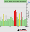
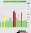
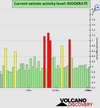
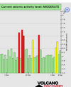
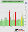
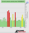
New Zealand’s best-known supervolcano hasn’t quietened, with scientists still recording around 20 local earthquakes at Taupō each week.

Yet there’s no indication that the enormous, lake-filled caldera volcano - where GeoNet’s alert level was raised to one for the first time ever in September – is at any immediate risk of eruption.

Lake Taupo is the crater of a massive super volcano and the risk of eruption for the first time in recent history was increased from zero to one back in September. Last nights quake marks the peak of its activity so far.

Scientists were working to develop a range of possible future scenarios for Taupō – and an actual eruption remained a decidedly unlikely one.

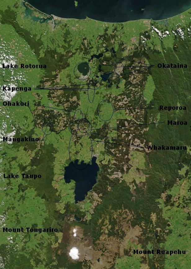
Lake Taupō, in the centre of New Zealand's North Island, is the calderaof the Taupō Volcano, a large rhyolitic supervolcano. This huge volcano has produced two of the world's most violent eruptions in geologically recent times.

The timeline of Taupo eruptions is interesting in that I wonder if it coincides with astronomical cycles?

Taupō volcano first began to erupt over 300,000 years ago. It is very large and has many vents, most of which are now under Lake Taupō. Geological studies of Taupō show that the volcano makes up only the northern half of the lake and a small surrounding area but there have been numerous eruptions from different sites within this large volcano. Taupō is not a large mountain because the eruptions have been so explosive that all material has been deposited far from the vent and subsequent collapse of the ground has formed a caldera (a collapsed volcano).

Most Recent Eruption​

Whenabout 1,800 years agoWherenorth-eastern Lake TaupōEffectsThe Taupō eruption was the most violent eruption in the world in the last 5,000 years; it was a complex series of events. The first phases of the eruption produced a series of five pumice and ash fall deposits over a wide area of the central North Island, especially east of Taupō and beyond Napier into Hawke Bay. The eruption culminated with a large and very energetic pyroclastic flow that devastated an area of about 20,000 km2 and filled all the major river valleys of the central North Island with pumice and ash. These pumice deposits can still be seen today and many of the major rivers in the North Island carry large amounts of this pumice when in flood. Rounded pumice found on the beaches of the North Island have come from this eruption. The Taupō eruption took place from a line of vents near the eastern side of the modern lake.
 
Last edited:
WORLDWIDE EARTHQUAKE REPORT NOVEMBER 30

As mentioned earlier in this thread, five days appears to be a recurring interval from the moment of an atmospheric fluctuation and a strong/major earthquake. An alert of potential and strong seismic activity for the regions in the purple band was issued on November 25 by SSGEOS. Another alert was issued yesterday November 29 for the same region. This suggests that the M5.7 earthquake in Iran is a precursor.


Iran is crisscrossed by major geological fault lines and is one of the most earthquake-prone countries in the world because it is located where the Arabian, Indian, and Eurasian tectonic plates meet.
earth-s-tectonic-plates.jpg
Iran has had a terrible history of massive earthquakes in recent decades, with some killing up to tens of thousands of people and causing billions in damages, such as the magnitude 6.6 quake in Kerman province in 2003 that killed 31,000 people and flattened the ancient city of Bam.

The tectonic platform in the Iranian region has been very active this year, with a series of earthquakes measuring five or more on the Richter scale, often felt in the Emirates.

Two weeks ago tremors were felt following an earthquake in Iran that measured 5.3 on the scale.

Strongest foreshocks

~M 4.2 - 41 km northeast of Bandar-e Lengeh, Hormozgan, Iran
~M4.6 - 45 km northeast of Bandar-e Lengeh, Hormozgan, Iran

Other M5+ earthquakes

● M 5.4 - 20 km SW of Taupo, New Zealand
2022-11-30 10:48:00 (UTC)
38.808°S 175.906°E. 7.8 km depth
USGS earthquake alert

M 5.0 - near the east coast of Honshu, Japan
2022-11-30 03:45:59 (UTC)
37.265°N 141.699°E 53.3 km depth
USGS earthquake alert

● Summary

Seismic activity level has been at  moderate levels in the last 24 hours. This is the last chart posted by Volcanodiscovery 01:50 UTC on November 30 Global seismic activity level chart

~3 quakes above magnitude 5
~45 quakes between magnitude 4 and 5
~115 quakes between magnitude 3 and 4
~357 quakes between magnitude 2 and 3
~559 quakes below magnitude 2 that people normally don't feel.
~1079 earthquakes in the past 24h (971 earthquakes in the 24 hours prior to this report) Estimated combined seismic energy release: 14100 tons of TNT or 0.9 atomic bombs
Volcanodiscovery earthquake report 24h
 

Attachments

  • chrome_screenshot_1669853574645.png
    chrome_screenshot_1669853574645.png
    331.3 KB · Views: 0
WORLDWIDE EARTHQUAKE REPORT DECEMBER 01

A series of tremors struck the caldera region of the Taupo volcano in New Zealand. The strongest earthquake has been a M5.4. Scientists maintain a level 1 threat from the supervolcano, which is currently the world's most serious volcanic problem.

Its most powerful eruption took place 26,500 years ago and was one of the largest in human history. It emitted 300 cubic kilometers of pyroclastic material into the atmosphere.

Latest quakes near Taupo volcano in the past 24 hours

~6 quakes above magnitude 3
~79 quakes between magnitude 2 and 3
~103 quakes below magnitude 2 that people normally don't feel.

chrome_screenshot_1669945778597.png

An earthquake of magnitude 5.1 occurred 23 km southeast of David (pop.17400), Panama, the United States Geological Survey reported.
The quake hit at a moderately shallow depth of 38 km beneath the epicenter near David in the morning on Thursday, December 1st, 2022, at 8:30 am local time.

● M 5.1 - south of Panama
2022-12-01 13:30:50 (UTC)
7.603°N 82.384°W. 38.2 km depth
USGS earthquake alert

● M 5.4 - central Mid-Atlantic Ridge
2022-12-01 11:02:43 (UTC)
0.455°S 19.861°W. 10.0 km depth
USGS earthquake alert

● M 5.1 - 220 km SW of Bengkulu, Indonesia
2022-12-01 08:29:42 (UTC)
5.082°S 100.743°E. 10.0 km depth
USGS earthquake alert

Moderate earthquakes magnitude 4.7 and 4.2 hit northeast of Bandar-e Lengeh, Hormozgan, Iran, on Thursday, December 01 at 9:48 pm local time. These earthquakes are aftershocks of the 5.7 magnitude earthquake that shook Iran on November 30.

● M 4.7 - 44 km NE of Bandar-e Lengeh, Iran
2022-12-01 18:18:10 (UTC)
26.847°N 55.190°E. 10.0 km depth
USGS earthquake alert

M 4.2 - 44 km NE of Bandar-e Lengeh, Iran
2022-12-01 23:29:33 (UTC)
26.877°N 55.159°E. 10.0 km depth
USGS earthquake alert


● Summary

Seismic activity level has been at  moderate levels in the last 24 hours. This is the last chart posted by Volcanodiscovery 02:00 UTC on December 01 Global seismic activity level chart

~4 quakes above magnitude 5
~38 quakes between magnitude 4 and 5
~97 quakes between magnitude 3 and 4
~323 quakes between magnitude 2 and 3
~604 quakes below magnitude 2 that people normally don't feel.
~1066 earthquakes in the past 24h (1079 earthquakes in the 24 hours prior to this report) Estimated combined seismic energy release: 8606 tons of TNT or 0.5 atomic bombs
Volcanodiscovery earthquake report 24h
 

Attachments

  • chrome_screenshot_1669946658433.png
    chrome_screenshot_1669946658433.png
    327.7 KB · Views: 0
WORLDWIDE EARTHQUAKE REPORT DECEMBER 02

Strong magnitude 5.7 earthquake, South Atlantic Ocean, Bouvet Island at 12:35 pm on December 2 There are no nearby human populations and the nearest volcano is Bouvet, 65km away from epicenter. This earthquake is of the intra-plate type or within the African Plate.

● M 5.7 - Bouvet Island region
2022-12-02 12:35:11 (UTC)
53.954°S 2.742°E. 10.0 km depth
USGS earthquake alert

Moderate magnitude 5.1 earthquake near Tokoroa, Waikato, New Zealand on Saturday, December 3 at 2:09 am. According to GEONET-NZ the earthquake occurred north of Taupo volcano

● M 5.1 - North Island of New Zealand
2022-12-02 05:07:48 (UTC)
38.356°S 176.053°E. 168.2 km depth
USGS earthquake alert
chrome_screenshot_1670030015379.png

● M 5.0 - Sulawesi, Indonesia
2022-12-02 08:55:15 (UTC)
0.025°S 123.237°E. 155.2 km depth
USGS earthquake alert

● Summary

Seismic activity level has been at  moderate levels in the last 24 hours. This is the last chart posted by Volcanodiscovery 00:26 UTC on December 02 Global seismic activity level chart

~3 quakes above magnitude 5
~41 quakes between magnitude 4 and 5
~108 quakes between magnitude 3 and 4
~275 quakes between magnitude 2 and 3
~592 quakes below magnitude 2 that people normally don't feel.
~1019 earthquakes in the past 24h (1066 earthquakes in the 24 hours prior to this report) Estimated combined seismic energy release: 11623 tons of TNT or 0.7 atomic bombs.
Volcanodiscovery earthquake report 24h
 

Attachments

  • chrome_screenshot_1670027156434.png
    chrome_screenshot_1670027156434.png
    332.3 KB · Views: 0
WORLDWIDE EARTHQUAKE REPORT DECEMBER 03

A magnitude 6.4 earthquake near Banjar, (pop. 37,300 ) West Java, Indonesia, was reported by BMKG (Meteorological, Climatological, and Geophysical Agency of Indonesia) later the earthquake was updated to magnitude 5.7. According to BMKG, 31km away from epicenter is the Papadayan volcano. The earthquake occurred at an intermediate depth of 112.5 km beneath the epicenter in the afternoon on Saturday, December 3rd, at 4:49 pm local time.
chrome_screenshot_1670119114526.png

● M 5.7 - 18 km ESE of Banjar, Indonesia
2022-12-03 09:49:39 (UTC)
7.249°S 107.588°E. 112.5 km depth
USGS earthquake alert

A magnitude 5.1 earthquake 26 km away from Matthew Island Volcano and 368 km ESE of Tadine (Maré) (pop: 7,490)
chrome_screenshot_1670120350420.png

● M 5.1 - southeast of the Loyalty Islands
2022-12-03 11:00:36 (UTC)
22.562°S 171.278°E. 10.0 km depth
USGS earthquake alert

A magnitude 5.0 earthquake near Riosucio (pop.7,200 by the United States Geological Survey. The earthquake occurred at a shallow depth of 10 km beneath the epicenter early morning on Saturday, December 3rd, at 6:41 am local time. There is no volcanic activity near the epicenter.

● M 5.0 - 16 km SSE of Riosucio, Colombia
2022-12-03 11:41:37 (UTC)
7.305°N 77.076°W. 39.0 km depth
USGS earthquake alert

● Summary

Seismic activity level has been at  high levels in the last 24 hours. This is the last chart posted by Volcanodiscovery 00:30 UTC on December 02 Global seismic activity level chart (
chrome_screenshot_1670120717846.png
(Volcanodiscovery has not updated their data and still considers the earthquake in Indonesia as 6 4 so their graph shows a high level of seismic activity. Therefore, I consider that the activity has actually been moderate in the past 24 hours).

~3 quakes between magnitude 5 and 6
~44 quakes between magnitude 4 and 5
~103 quakes between magnitude 3 and 4
~239 quakes between magnitude 2 and 3
~532 quakes below magnitude 2 that people normally don't feel.
~921 earthquakes in the past 24h (1019 earthquakes in the 24 hours prior to this report) Estimated combined seismic energy release: 11639 tons of TNT or 0.7 atomic bombs.
Volcanodiscovery earthquake report 24h
 
Last week saw 3 M6 and 1 M7, being a M7.0 in the Solomon Islands.
In the usual area, there were 9 out of 138 earthquakes equal to or greater than 4.5 worldwide and 1249 out of 1703 quakes of all sizes.
Percentage: 73.3%
Last week saw no earthquakes worldwide reaching M6.0
In the usual area, there were 6 out of 110 earthquakes worldwide equal to or greater than 4.5 and 1444 out of 2191 quakes of all sizes.
Percentage: 65.9% (I think this is about the lowest in the last 3 years of having done this weekly roundup of this area.)
Earthquakes 7 days to Dec 4th 2022.gif
 
Strong mag. 6.7 earthquake - South Pacific Ocean, 222 km south of Apia, Tuamasaga, Samoa, on Monday, Dec 5, 2022 at 8:24 am
The nearest human population is Mulifanua (pop.4510) 214 km from the epicenter. The nearest volcano is Curocoa 126km from epicenter.

M 6.7 - 108 km NE of Hihifo, Tonga
2022-12-04 19:24:15 (UTC)
15.398°S 172.968°W. 36.0 km depth
USGS earthquake alert

Data for the same earthquake reported by different agencies
Mag.DepthLocationSource
6.9148 kmSamoa: 134 Km E of Hihifo, TongaUSGS
6.738 kmSamoa: Tonga IslandsGFZ
6.888 kmSamoa: Tonga IslandsGeoAu
6.710 kmSamoa: TONGAEMSC
6.510 kmSamoa: Near NouméaRENASS
6.736 kmSamoa Islands RegionRaspberryShake
6.710 kmSamoa Islands RegionIRIS
6.816 kmSamoa: Tonga Islands [Sea: Tonga]INGV
Volcanodiscovery
 
WORLDWIDE EARTHQUAKE REPORT DECEMBER 04

December 04 was not only a day of volcanic eruptions (Stromboli in Italy, Mount Semeru in Indonesia, Chaparrastique in El Salvador) but also a day of high seismic activity.

Gabon was shaken near Lambarene (pop.20,700) Moyen-Ogooué, by an earthquake of magnitude 5.5 The quake hit at a shallow depth of 3.6 km beneath the epicenter near Lambarene in the morning on Sunday, December 4th, 2022, at 10:53 am local time.

● M 5.5 - 37 km S of Lambaréné, Gabon
2022-12-04 09:53:11 (UTC)
1.037°S 10.218°E. 3.6 km depth
USGS earthquake alert

Since March 2021 Gabon had not recorded an M5.0+ earthquake. In fact moderate seismic activity began in 2021 when it recorded 4 earthquakes of Magnitude 4.0+ and two Magnitude 5.0+ Prior to this in 2019 an M5.3 earthquake was recorded and in 2014 the largest earthquake Gabon has ever felt occurred with a magnitude 6.9. In 1974 Gabon was shaken by an M6.2 earthquake.

A aftershock M5.1 from the M6.7

● M 5.1 - 176 km S of Matavai, Samoa
2022-12-04 23:38:21 (UTC)
15.605°S 171.930°W. 10.0 km depth
USGS earthquake alert

Reykjanes Ridge recorded two strong earthquakes

● M 5.2 - Reykjanes Ridge
2022-12-04 03:39:58 (UTC)
53.900°N 35.612°W. 10.0 km depth
USGS earthquake alert

● M 5.4 - Reykjanes Ridge
2022-12-04 11:13:59 (UTC)
53.944°N 35.558°W. 10.0 km depth
USGS earthquake alert

Very deep earthquakes

● M 5.0 - 96 km NNE of Paciran, Indonesia
2022-12-04 15:02:49 (UTC)
6.081°S 112.740°E. 599.4 km depth
USGS earthquake alert

● M 5.5 - southeast of the Loyalty Islands
2022-12-04 19:00:09 (UTC)
21.751°S 170.577°E. 144.0 km depth
USGS earthquake alert

● M 5.1 - 48 km SW of Andalgalá, Argentina
2022-12-04 21:04:24 (UTC)
27.935°S 66.604°W . 162.6 km depth
USGS earthquake alert

● M 4.4 - 11 km S of Lipari, Italy
2022-12-04 07:12:45 (UTC)
38.366°N 14.969°E. 10.3 km depth
USGS earthquake alert

● Earthquake Forecast: Potential for stronger seismic activity in or near the purple band (1-5 days From Alaska to South Pacific Ocean). This is an estimate. Other regions are not excluded.

● Summary

Seismic activity level has been at  high levels in the last 24 hours. This is the last chart posted by Volcanodiscovery 00:30 UTC on December 02 Global seismic activity level chart
~1 quake above magnitude 6
~7 quakes between magnitude 5 and 6
~36 quakes between magnitude 4 and 5
~88 quakes between magnitude 3 and 4
~237 quakes between magnitude 2 and 3
~437 quakes below magnitude 2 that people normally don't feel.
~806 earthquakes in the past 24h (921 earthquakes in the 24 hours prior to this report) Estimated combined seismic energy release: 1.8 x 10⁵ tons of TNT or 11.4 atomic bombs.
Volcanodiscovery earthquake report 24h
 

Attachments

  • chrome_screenshot_1670200479773.png
    chrome_screenshot_1670200479773.png
    314.4 KB · Views: 1

Very strong mag. 6.2 earthquake - Indian Ocean, 283 km south of Jember, East Java, Indonesia

Date & timeDec 6, 2022 06:07:48 UTC - 6 hours ago
Local time at epicenterTuesday, Dec 6, 2022 at 2:07 pm (GMT +8)
StatusConfirmed
Magnitude6.2
Depth10.0 km
Epicenter latitude / longitude10.7°S / 113.42°E
ID.png
(Indian Ocean, Indonesia)
Antipode10.7°N / 66.58°W
Shaking intensityModerate shaking
Felt73 reports
Primary data sourceBMKG (Meteorological, Climatological, and Geophysical Agency of Indonesia)

4 hours ago
 
WORLDWIDE EARTHQUAKE REPORT DECEMBER 06

The magnitude 6.2 earthquake reported by Meteorological, Climatological, and Geophysical Agency of Indonesia (BMKG) was updated to M5.9 The quake struck offshore and 269 km SSW of Gambiran Satu (pop: 22,500) at 02:07 pm local time. Then at 06:22 pm an aftershock of magnitude 5.2

● M 5.9 - 269 km S of Kencong, Indonesia
2022-12-06 06:07:48 (UTC)
10.718°S 113.388°E. 18.4 km depth
USGS earthquake alert

● M 5.0 - 62 km SSE of Gorontalo, Indonesia
2022-12-06 08:01:30 (UTC)
0.012°S 123.175°E. 166.3 km depth
USGS earthquake alert

● M 5.2 - 253 km S of Kencong, Indonesia
2022-12-06 10:22:03 (UTC)
10.572°S 113.429°E. 10.0 km depth
USGS earthquake alert

● M 5.5 - Mid-Indian Ridge
2022-12-06 09:34:51 (UTC)
40.815°S 78.636°E. 10.0 km depth
USGS earthquake alert

In the past 24 hours, Mongolia had 2 quakes up to magnitude 4.8 at 61 km west of Sainshand, East Gobi Aymag, on Wednesday, Dec 7, 2022 at 12:12 am.

● M 4.8 - 61 km WSW of Saynshand, Mongolia
2022-12-06 16:12:37 (UTC)
44.708°N 109.382°E. 10.9 km depth
USGS earthquake alert

● M 4.5 - 72 km SW of Turt, Mongolia
2022-12-06 14:40:18 (UTC)
50.990°N 100.024°E. 8.4 km depth
USGS earthquake alert
chrome_screenshot_1670371497293.png
A major magnitude 8.1 occurred 65 years ago in Mongolia. The quake hit 153 km southwest of Bajankhongor, Bayankhongor, Bajan-khongor, Mongolia, on Wednesday, December 4, 1957 at 03:37 UTC

Earthquakes in Mongolia since 1900
~3 quakes above magnitude 8
~9 quakes between magnitude 7 and 8
~35 quakes between magnitude 6 and 7
~247 quakes between magnitude 5 and 6

● Summary

Seismic activity level has been at moderate levels in the last 24 hours. This is the last chart posted by Volcanodiscovery 00:30 UTC on December 02 Global seismic activity level chart
~5 quakes between magnitude 5 and 6
~41 quakes between magnitude 4 and 5
~89 quakes between magnitude 3 and 4
~239 quakes between magnitude 2 and 3
~616 quakes below magnitude 2 that people normally don't feel.
~990 earthquakes in the past 24h (1022 earthquakes in the 24 hours prior to this report) Estimated combined seismic energy release: 39575 tons of TNT or 2.5 atomic bombs
Volcanodiscovery earthquake report 24h
 

Attachments

  • chrome_screenshot_1670372511835.png
    chrome_screenshot_1670372511835.png
    308.3 KB · Views: 0
WORLDWIDE EARTHQUAKE REPORT DECEMBER 07

Strong magnitude 5.4 earthquake in Solomon Sea, 179 km (111 mi) SE of Gizo (pop: 6,150) on Thursday, December 8, at 7:18 am. The earthquake occurred at a shallow depth of 10km. The Kavachi submarine volcano is located 24 km from the epicenter.

Kavachi volcano is a shallow submarine volcano located south of the remote Vangunu Island in the Solomones. It is als known as Rejo te Kvachi, "Kavachi's Oven", and one of the most active of the Pacific with near surface eruptions every few years that often build temporary islands.
May_14_Kavachi_eruption.jpg

● M 5.4 - 178 km SE of Gizo, Solomon Islands
2022-12-07 20:18:02 (UTC)
9.219°S 158.012°E. 10.0 km depth
USGS earthquake alert

An earthquake of magnitude 5.1 occurred 30 km southeast of Hualien City, (pop. 350,500) Taiwan. The quake hit at a shallow depth of 30.8 km beneath the epicenter near Hualien City, Hualien, Taiwan, after midnight on Thursday, December 8th, at 12:54 am local time.

A unnamed volcano (24.00°N/121.83°E) is 37 km away from epicenter. A submarine eruption observed by the U.S. Navy boat "Southampton" took place on October 29, 1853 in the Philippine Sea offshore from the city of Hualien about 18 km from the eastern coast of Taiwan. Several days later another ship, the "Macedonian," passed the same location and reported white ash covering its curtains.

● M 5.1 - Taiwan
2022-12-07 16:54:26 (UTC)
23.715°N 121.637°E. 30.8 km depth
USGS earthquake alert

Moderate magnitude 5.0 earthquake 214 km (133 mi) E of Amahai (pop: 47,700), Indonesia, on Wednesday, Dec 7 at 3:53 pm local time

● M 5.0 - 214 km E of Amahai, Indonesia
2022-12-07 06:53:18 (UTC)
3.406°S 130.849°E. 30.0 km depth
USGS earthquake alert

A 5.2-magnitude earthquake struck 38 km (24 mi) NNE of Sabang Indan (pop: 2,800) Philippines. The tremor was recorded around noon on Wednesday, December 7th, at 1:05 pm local time, at a very shallow depth of 8.4 km below the surface.

● M 5.2 - 38 km NNE of Sabang Indan, Philippines
2022-12-07 05:05:27 (UTC)
14.532°N 123.064°E. 9.0 km depth
USGS earthquake alert

● M 5.0 - South Sandwich Islands region
2022-12-07 04:01:54 (UTC)
60.920°S 25.383°W. 10.0 km depth
USGS earthquake alert

● Earthquake Forecast: Early on 8 December, during Full Moon, a near quadruple conjunction occurs with the Sun, Earth, the Moon and Mars. This could result in (some) stronger seismic activity in the following days.

● Summary

Seismic activity level has been at moderate levels in the last 24 hours. This is the last chart posted by Volcanodiscovery 01:08 UTC on December 07 Global seismic activity level chart
~5 quakes above magnitude 5
~33 quakes between magnitude 4 and 5
~99 quakes between magnitude 3 and 4
~252 quakes between magnitude 2 and 3
~614 quakes below magnitude 2 that people normally don't feel.
~1003 earthquakes in the past 24h (990 earthquakes in the 24 hours prior to this report) Estimated combined seismic energy release: 7684 tons of TNT or 0.5 atomic bombs
Volcanodiscovery earthquake report 24h
 

Attachments

  • chrome_screenshot_1670461607492.png
    chrome_screenshot_1670461607492.png
    321.1 KB · Views: 0
An earthquake of magnitude 5.8 occurred 14 km (9 mi) NW of Ciranjang-hilir (pop: 77,800) Indonesia The quake hit at an intermediate depth of 113 km beneath the epicenter in the morning on Thursday, December 8th at 7:50 am local time.

The earthquake had a preliminary magnitude 6.3 according to EMSC and 6.1 according to BMKG

Stratovolcano Gene-Pangrango is 20km away from epicenter. Gede volcano near Bogor is one of the most prominent volcanoes in western Java. Together with older Pangrango volcano to the NW it forms a twin volcano, with Pangrango volcano having the highest point at 3019 m.

M 5.8 - 14 km NW of Ciranjang-hilir, Indonesia
2022-12-08 00:50:57 (UTC)
6.738°S 107.159°E. 123.7 km depth
USGS earthquake alert

● Earthquake Forecast: Early on 8 December, during Full Moon, a near quadruple conjunction occurs with the Sun, Earth, the Moon and Mars. This could result in (some) stronger seismic activity in the following days.
 
WORLDWIDE EARTHQUAKE REPORT DECEMBER 08

Strong magnitude 5.4 earthquake occurred 184 km west of Hollandia, Papua, Indonesia, on Thursday, Dec 8, at 1:58 pm local time

● M 5.4 - 173 km W of Abepura, Indonesia
2022-12-08 04:58:58 (UTC)
2.787°S 139.081°E. 47.1 km depth
USGS earthquake alert

An earthquake of magnitude 5.5 occurred 29 km (18 mi) SW of Khadzhalmakhi (Levashinsky District) (pop: 6,090) Russia.
The quake hit at a shallow depth of 60 km beneath the epicenter in the morning on Thursday, December 8th, at 9:42 am local time.

● M 5.5 - Caucasus region, Russia
2022-12-08 06:42:15 (UTC)
42.273°N 46.894°E. 60.0 km depth
USGS earthquake alert

● M 5.1 - 140 km NE of Hihifo, Tonga
2022-12-08 10:06:38 (UTC)
14.951°S 172.992°W. 63.3 km depth
USGS earthquake alert

● M 5.4 - northern Mid-Atlantic Ridge
2022-12-08 12:44:02 (UTC)
45.273°N 27.911°W. 10.0 km depth
USGS earthquake alert

● M 5.3 - Pacific-Antarctic Ridge
2022-12-08 14:45:26 (UTC)
63.147°S 163.669°W. 10.0 km depth
USGS earthquake alert

An earthquake of magnitude 5.0 occurred 9 km (5 mi) SSE of Ayo (pop: 262) Peru. The earthquake hit at a shallow depth of 10km early evening on Thursday, December 8th, 2022, at 6:18 pm local time.

10 km away from epicenter is Huambo volcano, its current status is dormant.

● M 5.0 - 8 km SSE of Ayo, Peru
2022-12-08 23:18:58 (UTC)
15.757°S 72.248°W. 10.0 km depth
USGS earthquake alert


● Summary

Seismic activity level has been at moderate levels in the last 24 hours. This is the last chart posted by Volcanodiscovery 02:00 UTC on December 08 Global seismic activity level chart
~6 quakes above magnitude 5
~35 quakes between magnitude 4 and 5
~88 quakes between magnitude 3 and 4
~214 quakes between magnitude 2 and 3
~551 quakes below magnitude 2 that people normally don't feel.
~894 earthquakes in the past 24h (1003 earthquakes in the 24 hours prior to this report) Estimated combined seismic energy release: 11090 tons of TNT or 0.7 atomic bombs.
Volcanodiscovery earthquake report 24h
 

Attachments

  • chrome_screenshot_1670549093057.png
    chrome_screenshot_1670549093057.png
    323.2 KB · Views: 0
Sicily, Italy
8 Dec 2022

Worries are felt in Sicily over a possible, larger earthquake, given Sicily's history, for example devastating entirely the town of Catania twice ! A 4.1 M earthquake occurred near the town of Ragusa.

German Vulkane.net wrote following:


ML 4.1 earthquake in Sicily causes concern
9 December 2022 by Marc Szeglat

Sicily.jpg

Sicily: Earthquake ML 4.1 in the southeast of the island
Date: 8 Dec 2022 | Time: 20:26:34 UTC | 37.07 N ; 14.60 E | Depth: 10 km | Ml 4.1

Yesterday evening, a moderate earthquake of magnitude 4.1 occurred in southeastern Sicily. The earthquake focus was detected at a depth of 10 km. The epicentre was located between the provinces of Catania and Ragusa, 4 km from Mazzarrone.

The nearest major city is Ragusa, 20 km from the epicentre. The earthquake occurred at 21:26 local time and is causing some concern among Sicilians, as the earthquake manifested itself in an area where strong earthquakes have already occurred. These include the catastrophic earthquake of 1693, which destroyed many towns in the east of the island.

It had a serious impact on 70 towns and caused the death of about 60,000 people. Among them were a good two-thirds of the population of Catania. The city at the foot of Mount Etna is a good 65 km from yesterday's earthquake. The magnitude of the 1693 earthquake is estimated at 7.2 to 7.4. This made it the strongest earthquake ever to hit Italy. Other strong earthquakes have survived from 1169, 1542, 1818 and 1895.

In recent years, there have been 2 moderate earthquakes with magnitudes in the 4 range in the Ragusa region. They manifested in February 2016 and in December 2020. Since the strong earthquake of 1693 was also preceded by several weaker earthquakes, there is concern that the current quake sequence could also be foreshocks of a stronger earthquake.

Last month I had already noted that there seems to be a general increase in seismicity in the Sicily area.

Although Sicily is the largest island in the Mediterranean, the region is compact enough that there could be overriding connections affecting the stress field along several fault zones. From a tectonic point of view, the main component is certainly the plate collision of Africa and Europe, which is largely responsible for tectonic processes in this region. Another component that influences the tensions in the subsurface is the magma rise under Europe's largest volcano. This is, of course, Mount Etna. The magma rise is also related to the subduction of the African plate under the plate of Europe, although no lava is erupted at Etna, as is typical for subduction zone volcanism. Researchers assume that subduction creates a low-pressure zone in the mantle wedge under Etna, so that a suction effect is created on basaltic melt in the asthenosphere, which collects under Etna and causes the volcano to grow.

There are hypotheses that earthquakes in Sicily and the eruptions of the volcano influence each other. In 1669, there had been a devastating flank eruption on Etna when eruption fissures had opened relatively far down the volcano. Lava flows passed through Catania and ended up in the sea. This was the last flank eruption before the great earthquake of 1693. There had been no more major movements along Etna's rift zones and, according to one hypothesis, this helped build up stress along the main fault zones in southeastern Sicily. Meanwhile, 20 years have passed since the last flank eruption. On the other hand, there have been periods without flank eruptions on Etna before, without strong earthquakes. Such hypotheses can hardly be proven or disproven.

Speaking of Etna, the lava flow in the Valle del Leone is still active. Its thermal signature on the INGV livecam is stronger than ever. According to eyewitness reports, another vent opened above the active flow this morning. Long-term scientific forecasts are not possible, neither in terms of earthquake activity nor in terms of the volcano's eruptions. Nevertheless, I have the feeling that things could get exciting at Etna in the coming weeks.


END OF ARTICLE
 
Back
Top Bottom