You are using an out of date browser. It may not display this or other websites correctly.
You should upgrade or use an alternative browser.
You should upgrade or use an alternative browser.
Fires around the world
- Thread starter casper
- Start date

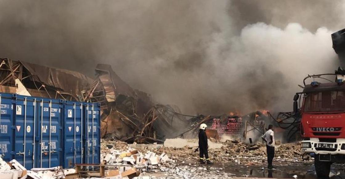
Porque 2020: Se incendia almacén de medicinas de la UNICEF en el Congo
Unicef informó un fuerte incendio en uno de sus almacenes, donde se destruyó una gran cantidad de medicinas, material y equipo destinado para niñas y niños.
 www.sopitas.com
Vigili del Fuoco
#Incendio in a textile company in Leffe (BG), from 1pm #vigilidelfuoco of #Bergamo , #Brescia , #Lecco is #Monza at work. Employees are autonomously evacuated, teams committed to limiting the flames to avoid the involvement of nearby structures
To add to the list, although possibly unrelated, apparently now the World Trade Centre in Brussels, Belgium, is on fire:
Added: Article:
"The future is here". Yeah, looks about right.
Yeah, I was suspicious at first of all those reported fires in Iran, for example. But it turns out this is probably almost purely an artifact of news reporting:One thing to note about these fires is that parts of the ME are having almost record temperatures. While it's interesting, we should be careful to avoid confirmation bias.
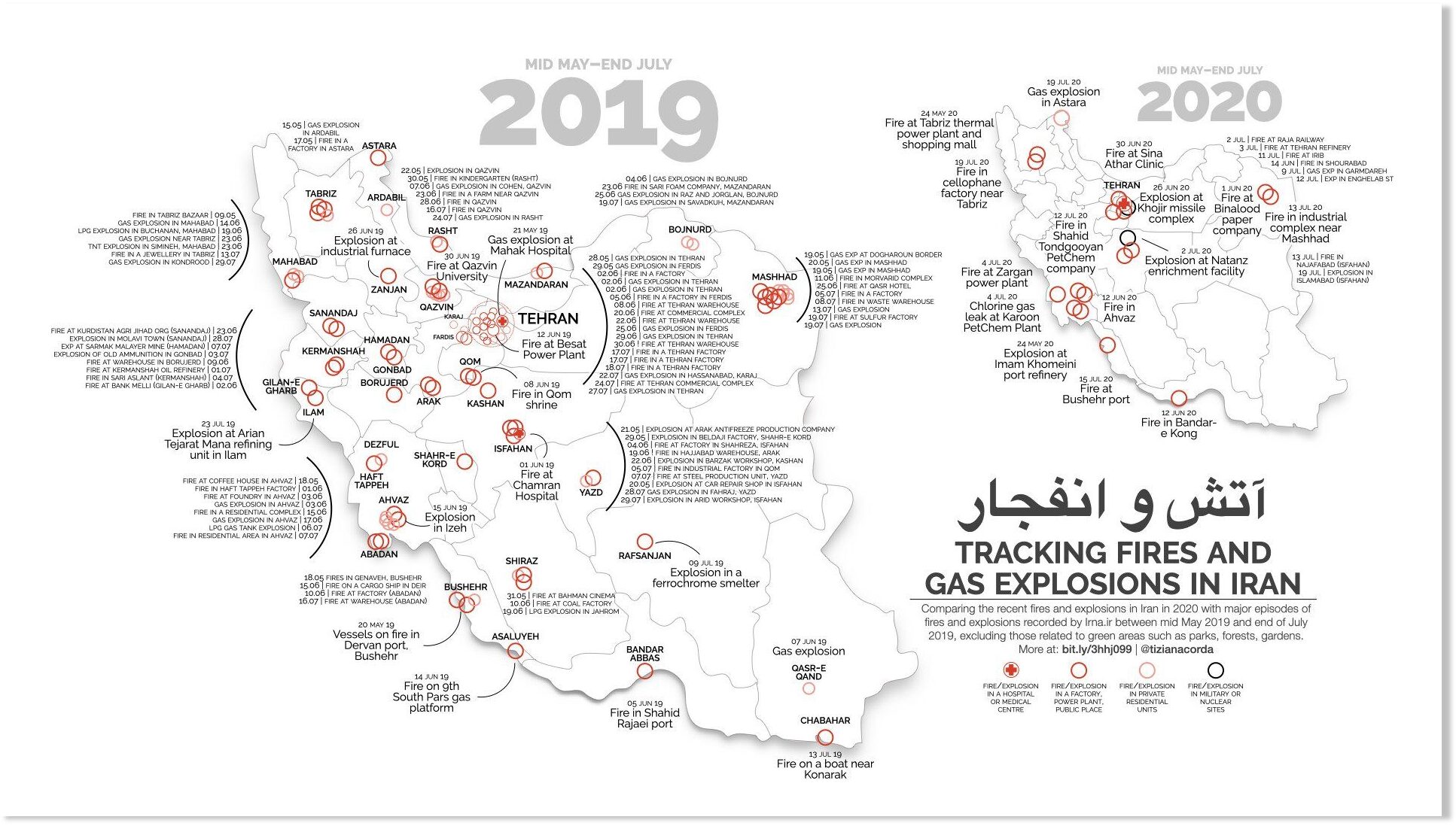
Not much to see here: Iran's fires and explosions, put in perspective
Amid growing interest from international media in Iran's fires and explosions over the past few weeks, some analysts stressed the need not to overemphasise these events. Especially in the summer, especially in a country with a record of (quite...
 www.sott.net
And now a gas station explosion in Volgograd, Russia killing at least 13 people 

 www.independent.co.uk
Huge explosion rips through gas station in Russia
‘The firefighters were literally scattered by a blast wave’
www.independent.co.uk
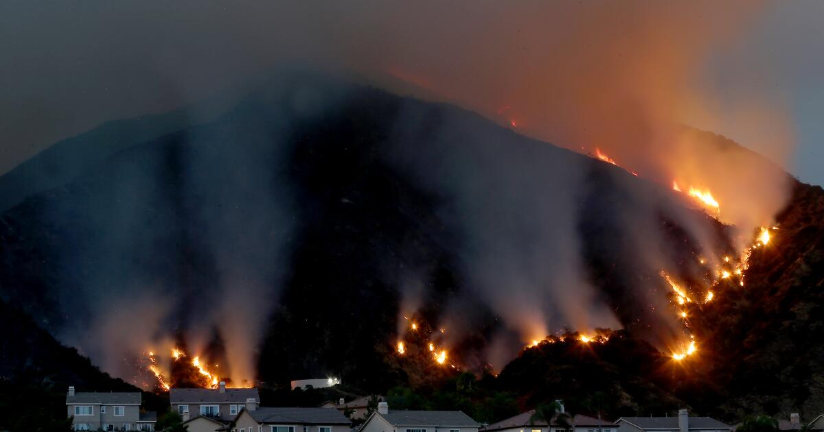
Lake fire. Southern California.

 www.foxla.com
LAKE HUGHES, Calif. - A fast-moving brush fire blackened 10,000 acres on Wednesday afternoon in Lake Hughes prompting mandatory evacuations for at least 100 homes, officials said.
www.foxla.com
LAKE HUGHES, Calif. - A fast-moving brush fire blackened 10,000 acres on Wednesday afternoon in Lake Hughes prompting mandatory evacuations for at least 100 homes, officials said.
CA Fire Scanner
"6,000 acres & it's approximately 1 hour 40 mins since the first call came in".
The "Lake Fire" was reported at about 3:30 p.m. near North Lake Hughes Road and Pine Canyon Road in the Angeles National Forest, according to Marvin Lim of the Los Angeles County Fire Department, which was assisting Angels National Forest crews.
An evacuation center has been set up at Highland High School in Palmdale, for residents displaced due to the fast moving fire.
The blaze had a "rapid rate of spread," and the ANF called in a second-alarm response at about 4 p.m.
By 4:30 p.m., the flames had burned 400 acres, according to the Los Angeles County Fire Department, which was working with the sheriff's department to evacuate Lake Hughes residents north of the fire
The sheriff's department is evacuating the area of Lake Hughes Road, west of Pine Canyon Road and south of Dry Gulch Road,
Pine Canyon Road at Highway 138, and Lake Hughes Road, west of Pine Canyon Road, are closed to traffic due to the fire, according to the Los Angeles County Sheriff's Department.
The fire was entirely on federal land as of 6:30 p.m., according to the Los Angeles County Fire Department.
By 7:15 p.m., the flames had jumped Pine Canyon Road, two miles west of Lake Hughes Road, and shortly after, flames were seen on aerial footage burning what appeared to be homes in the area. This is a developing story
Pine Gulch Fire Colorado
"At 51,455 acres, the Pine Gulch Fire is now the seventh-largest fire in Colorado history".
The state's 10 largest fires, ranked by acreage, are:
1. Hayman Fire (2002): 138,114 acres
2. West Fork Complex (2013): Several fires with a combined 109,632 acres
3. Spring Fire (2018): 108,045 acres
4. High Park Fire (2012): 87,284 acres
5. Missionary Ridge Fire (2002): 72,962 acres
6. 416 Fire (2018): 54,000 acres
7. Pine Gulch Fire (2020): 51,455 acres
8. Bridger Fire (2008): 45,800 acres
9. Last Chance Fire (2012): 45,000 acres
10. Bear Springs/Callie Marie fires (2011): 44,662 acres
Brush fire burning near Lake Hughes reaches 65% containment; evacuation orders to be lifted
Firefighters made progress Monday in the effort to put out the 31,089-acre brush fire near Lake Hughes, which has destroyed 12 structures and 21 outbuildings.
CA Fire Scanner
"6,000 acres & it's approximately 1 hour 40 mins since the first call came in".
The "Lake Fire" was reported at about 3:30 p.m. near North Lake Hughes Road and Pine Canyon Road in the Angeles National Forest, according to Marvin Lim of the Los Angeles County Fire Department, which was assisting Angels National Forest crews.
An evacuation center has been set up at Highland High School in Palmdale, for residents displaced due to the fast moving fire.
The blaze had a "rapid rate of spread," and the ANF called in a second-alarm response at about 4 p.m.
By 4:30 p.m., the flames had burned 400 acres, according to the Los Angeles County Fire Department, which was working with the sheriff's department to evacuate Lake Hughes residents north of the fire
The sheriff's department is evacuating the area of Lake Hughes Road, west of Pine Canyon Road and south of Dry Gulch Road,
Pine Canyon Road at Highway 138, and Lake Hughes Road, west of Pine Canyon Road, are closed to traffic due to the fire, according to the Los Angeles County Sheriff's Department.
The fire was entirely on federal land as of 6:30 p.m., according to the Los Angeles County Fire Department.
By 7:15 p.m., the flames had jumped Pine Canyon Road, two miles west of Lake Hughes Road, and shortly after, flames were seen on aerial footage burning what appeared to be homes in the area. This is a developing story
Pine Gulch Fire Colorado
"At 51,455 acres, the Pine Gulch Fire is now the seventh-largest fire in Colorado history".
The state's 10 largest fires, ranked by acreage, are:
1. Hayman Fire (2002): 138,114 acres
2. West Fork Complex (2013): Several fires with a combined 109,632 acres
3. Spring Fire (2018): 108,045 acres
4. High Park Fire (2012): 87,284 acres
5. Missionary Ridge Fire (2002): 72,962 acres
6. 416 Fire (2018): 54,000 acres
7. Pine Gulch Fire (2020): 51,455 acres
8. Bridger Fire (2008): 45,800 acres
9. Last Chance Fire (2012): 45,000 acres
10. Bear Springs/Callie Marie fires (2011): 44,662 acres
The fire was started by lightning on July 31. It’s spreading to the northeast.
Evacuated areas are as follows:
– County Road 204/Roan Creek Road
– 211/Clear Creek Road
– 207/Carr Creek Road
– 209/Brush Creek Road
– A small number of homes on County Roads 200 and 202
Air quality issues will continue for a large segment of Colorado through at least Friday due to both the Pine Gulch Fire and the Grizzly Creek Fire near Glenwood Springs. Alerts are in effect for areas west of Vail and Rabbit Ears Passes including Routt, Rio Blanco, Garfield, Eagle, and Mesa Counties because of heavy smoke from the fires.
 www.latimes.com
Snip: Friday, August 14, 2020
www.latimes.com
Snip: Friday, August 14, 2020
Officials issued mandatory evacuation orders Thursday afternoon as the Ranch fire threatened Azusa’s Mountain Cove community.
The Los Angeles County Fire Department was alerted to the brush fire at 2:45 p.m., spokeswoman Leslie Lua said. Firefighters responded to North San Gabriel Canyon Road and North Ranch Road.
By about 6 p.m., the fire had burned 2,500 acres, according to the Fire Department. Officials said the fire is moving into a forested area and away from homes. No damage has been reported to structures.
Residents in the community of Mountain Cove who live north and west of Turning Leaf Way and Boulder Ridge Court, as well as south of Highwood Court, are under mandatory evacuation orders, the Azusa Police Department wrote on Facebook.
craig philpott @CphilpottCraig
Fire timelapse 4:30-5:00pm today #RanchFire NE of Azusa CA. #calfirecamera CollegePeak
@AlertWildfire@SCE
Evacuated areas are as follows:
– County Road 204/Roan Creek Road
– 211/Clear Creek Road
– 207/Carr Creek Road
– 209/Brush Creek Road
– A small number of homes on County Roads 200 and 202
Air quality issues will continue for a large segment of Colorado through at least Friday due to both the Pine Gulch Fire and the Grizzly Creek Fire near Glenwood Springs. Alerts are in effect for areas west of Vail and Rabbit Ears Passes including Routt, Rio Blanco, Garfield, Eagle, and Mesa Counties because of heavy smoke from the fires.
Ranch fire triggers evacuations for residents of Azusa's Mountain Cove community
Officials issued mandatory evacuation orders Thursday as the Ranch fire threatened homes in Azusa's Mountain Cove community.
www.latimes.com
Officials issued mandatory evacuation orders Thursday afternoon as the Ranch fire threatened Azusa’s Mountain Cove community.
The Los Angeles County Fire Department was alerted to the brush fire at 2:45 p.m., spokeswoman Leslie Lua said. Firefighters responded to North San Gabriel Canyon Road and North Ranch Road.
By about 6 p.m., the fire had burned 2,500 acres, according to the Fire Department. Officials said the fire is moving into a forested area and away from homes. No damage has been reported to structures.
Residents in the community of Mountain Cove who live north and west of Turning Leaf Way and Boulder Ridge Court, as well as south of Highwood Court, are under mandatory evacuation orders, the Azusa Police Department wrote on Facebook.
craig philpott @CphilpottCraig
Fire timelapse 4:30-5:00pm today #RanchFire NE of Azusa CA. #calfirecamera CollegePeak
@AlertWildfire@SCE
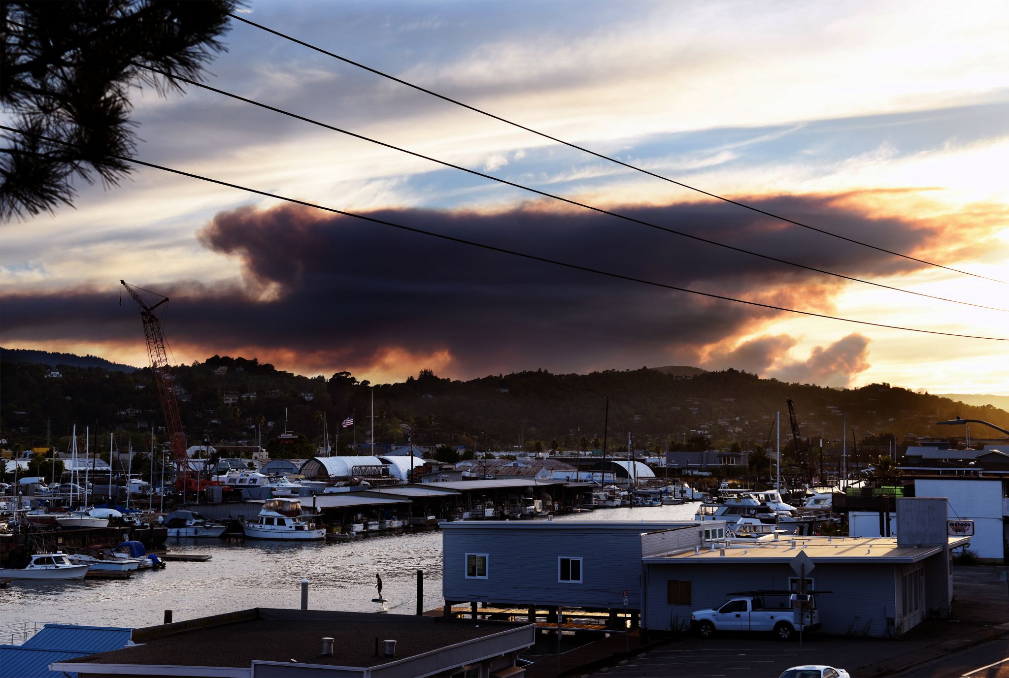
NAPA, Calif. - Evacuation orders remain in effect Tuesday in Napa County because of a growing wildfire sparked by lightning, one of three major fires burning in the region.
By Tuesday afternoon California Gov. Gavin Newsom declared a Statewide Emergency due to the fires and extreme weather conditions.
“We are deploying every resource available to keep communities safe as California battles fires across the state during these extreme conditions,” Newsom said. “California and its federal and local partners are working in lockstep to meet the challenge and remain vigilant in the face of continued dangerous weather conditions.”
Earlier this week the governor secured Fire Management Assistance from the Federal Emergency Management Agency to help with the response to fires burning in Napa, Nevada and Monterey counties.
The names of the fires: The Hennessey Fire near St. Helena, the Gamble Fire and the 15-10 Fire.
The Hennessey Fire was of most concern to firefighters and residents as it was threatening homes near Highway 128 and Hennessey Ridge Road. This fire grew in size slightly; as of Tuesday morning, it was 2,700 acres and was 0% contained. CalFire officials says it destroyed one structure and at least two outbuildings.
The evacuation orders were in effect for 20 homes and 200 other residences in the area.
"If you're in one of those warning areas, be ready to go because those orders could change anytime," said CalFire spokesman Will Powers.
The Gamle Fire burning near Lake Berryessa grew from 600 acres on Monday night to 5,000 acres by Tuesday morning. It was also 0% contained, but there were no evacuation orders in effect because of it.
The third large fire, the 15-10 Fire was burning near the Putah Creek Bridge and Berryessa Knoxville Road.
It started as a cluster of smaller brush fires, sparked by lightning, but overnight, merged into a larger fire. CalfFire counted at least 59 small fires sparked by lightning - so many, they started numbering them instead of naming each one.
"What we saw yesterday hadn't happened in 50 years," said former FEMA coordinator Mark Neveau. "That was the number of lightning strikes, up and down the state."
The rare weather has put a strain on the state's firefighting resources.
"There is so much going on right now," Neveau said. "We're seeing a stretch in the level of resources.
EVACUATIONS AND ROAD CLOSURES
An evacuation order update Tuesday evening included, Wragg Canyon Rd. from Highway 128 to the end of the road, including Pleasure Cove Resort. And Chiles Pope Valley Road, from lower Chiles Pope Valley Rd. to Pope Canyon Road.
Evacuation order issued for Berryessa Estates and Spanish Valley, in addition to new road closures.
An evacuation order has been issued for Snell Valley Road and Butts Canyon Road including Berryessa Estates and Spanish Valley. Residents can proceed to Crosswalk Community Church at 2590 1st Street in Napa.
On Monday afternoon, the evacuation order was updated to include all areas on Berryessa Knockville Road from Eastside Road to Highway 128 at the intersection of Berryessa Knoxville Road / Highway 128 (Turtle Rock Bar).
An evacuation warning has been issued for Butts Canyon Road from the Lake County line to James Creek Road in Napa, in addition to Markley Cove Resort to Pleasants Valley Road.
An additional road closure has been ordered at Highway 128 between Wragg Canyon Road and Pleasants Valley Road.
Video / 08:20
Point Reyes National Seashore wildfire now threatens 1,600 structures
A fire burning in the Point Reyes National Seashore grew to 1,500 acres overnight and is...
MORE WILDFIRE COVERAGE:
6 buildings destroyed, 1,527 threatened by River Fire near Salinas
Napa County wildfires trigger more evacuations, winery threatened
San Mateo County brush fire triggers evacuations
'Evacuate immediately': More Sonoma residents told to leave homes
Deer Complex fires at 1,450 acres, 0 percent contained
2 more California fires being reported in Northwest Sonoma county:
Sonoma County Scanner Updates (@SonomaScanner) on Twitter Posts updates regularly for anyone interested.
Also, still not tracked by CalFire last I checked (site is down currently)
Sonoma County Scanner Updates (@SonomaScanner) on Twitter Posts updates regularly for anyone interested.
Also, still not tracked by CalFire last I checked (site is down currently)
Headline: MOSCOW, July 27, 2020 - Forest fires in Russia more than doubled in size in the past week, a forestry official told TASS on Monday.
Notwithstanding the current fires in California and elsewhere, had started to follow some of the headlines/stories on Russian forest fires, and although pretty familiar with these events in Canada, Russia is a whole other story (which requires some looking at various indicators, such as forest age-class, species and fire return intervals (FRI) etc.) So, without the need for great emphasis, there is no doubt wildfires can be and are terrifying events depending on their rank and community proximity. Headlines echo these matters, people observe them first hand, and people can and have lost everything to them; the lives of loved ones, their houses and communities, and indeed there have been some fierce firestorms over the years – BC enough-times in my life; Fort Mac, Alberta destroyed, California burns - often, Australia, as people know from this past season, and Russia, as the headline above describes. Going back in time, Russia has been recorded through the news lens over many years, and it became how it was recorded that was with some interest. For instance, the above is from news agency TASS less than a month ago, and it grew in size. News sources become more interesting, described later.
In the norther hemisphere it is well into fire season, and this got me thinking on what has been seen over the decades and what headlines have said and how it is thought about on a landscape level. For instance, boreal forest fires are pretty tough to deal with - impossible really. In norther Canada they run on any given year, and there is nothing to do with them other than in the case of northern communities wherein you can try to steer these firestorms around them, if lucky. Fortunately, communities are few and far between. Russia is no different, and much bigger.
So, had never looked at wildfire stats from Russia, although observations have been made from articles, as said, over the years, so it was time to look briefly at some papers (and there are not many without more time and the resources to find them). In reality, one would need to have a complete forest inventory of species and growth compilations, and it would be useful to have orthophotos to look at historical detail, yet that is a big undertaking if you even had the data available. Some of the data found provides a little. However before exploring this, though, a scan of headlines from the western press and Russian press actually confused the issue. Both western and Russian press (like The Moscow Times) are peppered with reference to Greenpeace, the great environmental consciousness with a megaphone that echoes around the world - far from their days of saving whales and warning about war. Thus, these messages now are picked up by many aligning ‘groups’ and copied and pasted. Editors have their way with them, even Greta might have a word or two on how her childhood has been ruined because of them, yet mostly it attracts more funding to NGO's and university groups, groups who write some rather filtered findings - always with carbon worked in, which obviously is a delight for the IPCC. However, filtering further down these headlines then land in the laps of politicians who make hay with their words, as readers have all seen. These days, with fires in any country in the world, the one consistent message must be focused on carbon and people, it just has to be there as a reminder, and the arrows currently are pointing at Russia often enough when it comes to wildfires (or many other spotlights de jour). Moreover, some of the old pioneer environmentalist/biologist/ecologists/foresters have written some nifty books over the years, some good, some not so good, and most now have an agreed upon agenda. With some of the former group (most now), spending much of their discourse on the subject of carbon – it is very important to them, and they have all kinds of mathematical ways to present it. I used to pay attention to these numbers when they first came out, yet pretty much gave up on the whole idea of carbon (although it can tell a number of stories etc.) as it wanes and waxes and spews from volcanoes and other source from our yearly life on the planet. Fire weather is different, and here it comes back to a discussion between Russia and Canada and FRI’s.
Going back to recent headlines on Russian forest fires from 2020 and a few from 2019, they tend over the years to be framed to tell particular stories to western readers it seems. Here is one example of many {added some comments}:
From Greenpeace International August 19, 2019 (i.e. Russian Greenpeace (GP) here):
Please have a look at the photos, because what can be observed are pretty low fire indices e.g. indices that either produce or do not produce certain characteristics. One can see these fires, with the exception of one photo – and even at that it is telling a different story, which is that they are here more or less ground fires running under the forest canopy and they are not hot rank fires; remember this because it is a constant condition in Russia’s boreal forest FRI’s. This does not suggest that there are not some high ranking fires during periods of high indices in certain forested stands, it just does not seem to be the norm.
Here are a few more of their words:
Their point here seems to be that there are microsites that have high drought conditions and the trees are impacted by fire/heat on their root systems and into the canopy, while other microsites see less impact.
Apparently, the speaker woke one day only to realize that forests are burning – never happened before, omg “I take pictures, through my own tears”. Seriously.
It may look to the casual view as something ‘everybody’ needs to be writing Putin about, yet hold your horses and pens. It is here where these excited GP folks have cooked up 90% figures of human cause, which is very important to their narrative for the human angle – and it has some justification (murky as it is and as a measure of a location and not the whole of the Russian taiga). Notice how they said “most’ related to Siberia and the Far East while citing logging, roads and rivers where people have campfires (they must have seen those camp fires from satellites). Tricky how they wrote it as a reader can get lost equating Siberia and the Far East with all of Russian forests without factoring in Russia’s 11 time zones and a single transportation corridor. What are they actually talking about in terms of ‘roaded’ terrain and where they log? This is important and their language hides some of that terrain where there are no roads and no logging possible; would suggest it is a lot of terrain.
Firefighters are courageous, and it is darn hard work, yet crews armed with Pulaski’s against mother nature’s continual workings is not a reality for most of Russia nor Canada. Russia can only feasibly (stated in another paper below) manage what is in the protection zones, which are not that big considering the size of Russia (and it is understandable). What’s sad are these GP's collective press officer’s in their 320 km flight to the taiga to document it all and sell it to westerners.
That is their main message in red, people are the cause, hence the AGW shtick. People vs Natural ignitions is further brought up in a paper, yet it is murky also, and it must be kept in context with the transportation corridors, Siberian cities and villages (around 36 million live East of Moscow in these areas – the population of California) and the proportional representation of people spread out among the Russian terrain landscape.
Russian authorities don’t fight them all (just as with most geo-locations in Canada) because it is impossible logistically to do so. Towns and villages will always have some measures, very important, and by the sounds of the FRI’s in Russia it is not as intense as in some place in Canada with different FRI’s. In Russia, firefighting measures around cities, towns and villages are not ignored either.
Note on Weather: Finding solid weather data for Russia's vast landscape is not easy, and there has been warming (and cooling) as noted in Siberian and norther permafrost bogs opening up (Canada has this also) - and possibly heating up from underneath. There is a link to Russian weather data, yet I can't read it and again, not so sure it is that extensive as a representation (temp/humility/wind), just as Canada does not have a full picture of its boreal forests, although they have many remote weather stations.
Here is how GP ends it with a link over to Bloomberg for the big picture:
Bloomberg has a number of graphics (and carbon-centric at that) and a few photos. There is no doubt it was dry that year and the indices were high, yet even the photos reviewed (colour of smoke and its spottiness) indicate that the FRI and the species composition were factors - this looks to wildfire characteristics from year to year creating natural fire breaks in the next years FRI’s. However in this 2019 article, Putin responded with a massive firefighting resources while the word watched and scolded the Russian's in the press (Bloomberg here and many others) - and these same statement are repeated even in the 2020 fire season that:
This is from The Moscow Times and is consistent with quoting as the source, GP Russia. This year it is the size of Greece and last year it was the size of Belgium, next year it will be the size of pick your country.
Here is another example of a western MSN headline with a lens on Russia and forest fires - the headline reads (from a few weeks ago) ‘Wildfires in Siberia have burned down an area larger than Greece’ - yup, same talking point, and yes, that is a very large area as Greece is 131,940 sq km (or 13,194,000 ha.) - a map shows the overlay.

Looks big, and yet was that fire continuous or broken up? Does not say. Moreover, the areas burned flip flops in size from source to source - 13 million ha. to much less.
In the lead off Headline at the top of the page it cites that 44,500 ha. were impacted by a forest fire, and that is daunting to think about, and yet forests of Russia makes up 22% of the worlds forest and covers from 30 degrees east to 180 degrees - see map.

From that link (with a green axe to grind) it says:
A few choice green scare tactic words aside, as a source of timber, most of Russia is not well roaded through its eleven time zones to make it even a source, let alone viable after shipping to ports, nor does Canada at 7% of the world’s boreal forests in six time zones allow for northern road access. Nonetheless, a ha. here or there from the link, once things get burning, only mother nature ends up putting a them out.
Here is a map of the main road corridor through Russia:

As for size (and this gets really muddy with people citing sq.km. to ha., and as example (we had Greece above as a whole body), recall the Tunguska meteor took out 215,000 sq/ha. of forest and no one other than local tribes new it had happened – this kind of gives a person a lens on how big these Russian forests are. When looking at what seems like a large number (Tunguska was), what does it look like in the bigger landscape level picture. For instance, the Canadian city of Ottawa comes in at a rounded off 2,700 sq/km. (270,000 sq/ha.) combined area, so that is larger than the area of the Tunguska's impact upon the forest, yet it shows you what that impact would do over Ottawa.
Here is a map of Ontario with Ottawa in the far south east corner. Ontario is approximately 1,076,395 km2 (or 107,639,500 ha.)

Here is all of Canada overlaid on Russia, so you can fix Ontario from that (107,639,500 ha):

There is a paper Abstract here from 2013 that looks to Canadian (Western) vs Russian (Central) Forest fires (never mind the carbon emissions data for the IPCC folks):
It is these return intervals that are important relating to fuel, and they don't seem to have very good Russian data, which Russia may have or not (harder to obtain given the size). However this gets into the higher frequencies and small sizes (Canada) which equates to more fuel on the forest floor and canopy based on longer return intervals = 179 years in Canada vs 53 years in Russia = the latter sees faster return intervals, less fuel on the forest floor and canopy (less mature forests), at least that is what it seems to be saying aside from the carbon release data that usually peppers most of the data (and its okay to mention it, not okay in how it is used).
Coming back to News for 2020, one can read from Moscow Times (July 27, 2020) and here for July 20, 2020):
Aviales is the Russian Forest Agency.
Here is the Siberian Times from July 27, 2020.
Russia Insider and Pravda, nothing.
Moving over to Tass (July 27, 2020):
This paper 'Analysis of the Distribution of Forest Fires in Russia' is behind a paywall, and it is a bit pricey, however it provides some similar discussion, at a glance, as did the one above from Canada/Russia fire return intervals.
This may offer a good background based on the data it seems to say it collected.
Now this is from the US Forest Service 'Fire in Siberian Boreal Forests — Implications for GlobalClimate and Air Quality' (Pdf.) with emphasis on carbon, yet it was worth a read because it aids in some of the FRI language and also species composition data. Here is a bit of it:
Notice it says "about 80 percent of the area typically burns in surface fires" unless (probably like this year 2020) it goes to crown fires. When looking at photos and considering the fire return intervals, the majority seem to creep under the canopy with less fuel as part of a quicker FRI. Whereas in the Canadian study the returns were well spread out "179 years in Canada"(in that sense they burn hot and are often full crown fires as they are loaded with fuel from the longer interval periods of growth. Factoring species, in Russia larch was dominating.
Going back to human cause for fires as discussed above by GP, it is reasonable to suggest that along the road corridors with cities, towns, villages, there will be network roads for harvesting resources and fire may start as a result of people; their numbers seem high. Here is what they say in this study (much conjecture):
Yes, lightning detection has advanced and records well what happens. However these guys double back to say that it is still largely human cause, yet if the same data is taken from Canada, lightning rules in norther areas. Again, there is so much uninhabited areas of Russia that lightning must be underrated also. Have a look at this map for habitation densities and one can get a picture of what it looks like in Russia (and Canada for that matter). Much of Russia is < 2 people per sq.km. (and 2 10 per sq.km.).
Whatever the case, 2020 has had some big fires, and these fires have a FRI cycle that can, from time to time, encompass large areas as stated, yet not necessarily a continuous large area burned as the headlines demand. As ecosystems go, whether in Canada or Russia, wildfire play an important role at regeneration, removing fuel, opening up animal habitat, and is a constant for forest health by reducing pathology (blights to insect buildups).
The most interesting thing about this has been to see how (even with some Russian news outlets) there is such a reliance upon Russia Greenpeace data (this was surprising) - which looks sketchy, along with the overall lack of forest data with much speculation. Of course the mass focus is all on carbon, and people as a constant theme, which fits with their anti-Russian government talking points echoed down the line in most, if not all, western press headlines and text body.
This just scratches the surface and it would be interesting to look at real Russian data.
Notwithstanding the current fires in California and elsewhere, had started to follow some of the headlines/stories on Russian forest fires, and although pretty familiar with these events in Canada, Russia is a whole other story (which requires some looking at various indicators, such as forest age-class, species and fire return intervals (FRI) etc.) So, without the need for great emphasis, there is no doubt wildfires can be and are terrifying events depending on their rank and community proximity. Headlines echo these matters, people observe them first hand, and people can and have lost everything to them; the lives of loved ones, their houses and communities, and indeed there have been some fierce firestorms over the years – BC enough-times in my life; Fort Mac, Alberta destroyed, California burns - often, Australia, as people know from this past season, and Russia, as the headline above describes. Going back in time, Russia has been recorded through the news lens over many years, and it became how it was recorded that was with some interest. For instance, the above is from news agency TASS less than a month ago, and it grew in size. News sources become more interesting, described later.
In the norther hemisphere it is well into fire season, and this got me thinking on what has been seen over the decades and what headlines have said and how it is thought about on a landscape level. For instance, boreal forest fires are pretty tough to deal with - impossible really. In norther Canada they run on any given year, and there is nothing to do with them other than in the case of northern communities wherein you can try to steer these firestorms around them, if lucky. Fortunately, communities are few and far between. Russia is no different, and much bigger.
So, had never looked at wildfire stats from Russia, although observations have been made from articles, as said, over the years, so it was time to look briefly at some papers (and there are not many without more time and the resources to find them). In reality, one would need to have a complete forest inventory of species and growth compilations, and it would be useful to have orthophotos to look at historical detail, yet that is a big undertaking if you even had the data available. Some of the data found provides a little. However before exploring this, though, a scan of headlines from the western press and Russian press actually confused the issue. Both western and Russian press (like The Moscow Times) are peppered with reference to Greenpeace, the great environmental consciousness with a megaphone that echoes around the world - far from their days of saving whales and warning about war. Thus, these messages now are picked up by many aligning ‘groups’ and copied and pasted. Editors have their way with them, even Greta might have a word or two on how her childhood has been ruined because of them, yet mostly it attracts more funding to NGO's and university groups, groups who write some rather filtered findings - always with carbon worked in, which obviously is a delight for the IPCC. However, filtering further down these headlines then land in the laps of politicians who make hay with their words, as readers have all seen. These days, with fires in any country in the world, the one consistent message must be focused on carbon and people, it just has to be there as a reminder, and the arrows currently are pointing at Russia often enough when it comes to wildfires (or many other spotlights de jour). Moreover, some of the old pioneer environmentalist/biologist/ecologists/foresters have written some nifty books over the years, some good, some not so good, and most now have an agreed upon agenda. With some of the former group (most now), spending much of their discourse on the subject of carbon – it is very important to them, and they have all kinds of mathematical ways to present it. I used to pay attention to these numbers when they first came out, yet pretty much gave up on the whole idea of carbon (although it can tell a number of stories etc.) as it wanes and waxes and spews from volcanoes and other source from our yearly life on the planet. Fire weather is different, and here it comes back to a discussion between Russia and Canada and FRI’s.
Going back to recent headlines on Russian forest fires from 2020 and a few from 2019, they tend over the years to be framed to tell particular stories to western readers it seems. Here is one example of many {added some comments}:
From Greenpeace International August 19, 2019 (i.e. Russian Greenpeace (GP) here):
The Russian wildfires in pictures
Wondering what an area of forest burning larger than Belgium looks like?
Greenpeace Russia has been documenting the wildfires, to show their effect, size and catastrophic impact on all of us.
[…]
We found satellite images of fires burning 320 kilometres away {just a short trip} so we took a small helicopter and flew over the fires in the taiga {note the map in the link of the taiga stretching around the northern hemisphere}. … Soon we saw a smoke column over the forest and fly into the smog. Quickly approaching furnace I must take pictures. I want to fix the disaster. I take pictures, through my own tears.
Please have a look at the photos, because what can be observed are pretty low fire indices e.g. indices that either produce or do not produce certain characteristics. One can see these fires, with the exception of one photo – and even at that it is telling a different story, which is that they are here more or less ground fires running under the forest canopy and they are not hot rank fires; remember this because it is a constant condition in Russia’s boreal forest FRI’s. This does not suggest that there are not some high ranking fires during periods of high indices in certain forested stands, it just does not seem to be the norm.
Here are a few more of their words:
We can see the area which has already burned. The trees stand like charred matches, and the ground is covered with sores. You can see how the fire destroyed the area as it scorches the ground while trees in the distance are clouded in a viscous smoke.
Their point here seems to be that there are microsites that have high drought conditions and the trees are impacted by fire/heat on their root systems and into the canopy, while other microsites see less impact.
Every day we are feeling the effects of climate change : from draughts (sic) in Africa, to monsoons in Southeast Asia. The wild forests of Russia are a big part of restoring climate balance to the planet, but now they are burning — they themselves turning into a cause of climate change.
Apparently, the speaker woke one day only to realize that forests are burning – never happened before, omg “I take pictures, through my own tears”. Seriously.
90% of wildfires in Russia are the result of human activities
, according to official statistics and Greenpeace’s own research . According to satellite imagery, most current Siberian and Far East wildfires started near logging sites, along roads and rivers where people have campfires.
It may look to the casual view as something ‘everybody’ needs to be writing Putin about, yet hold your horses and pens. It is here where these excited GP folks have cooked up 90% figures of human cause, which is very important to their narrative for the human angle – and it has some justification (murky as it is and as a measure of a location and not the whole of the Russian taiga). Notice how they said “most’ related to Siberia and the Far East while citing logging, roads and rivers where people have campfires (they must have seen those camp fires from satellites). Tricky how they wrote it as a reader can get lost equating Siberia and the Far East with all of Russian forests without factoring in Russia’s 11 time zones and a single transportation corridor. What are they actually talking about in terms of ‘roaded’ terrain and where they log? This is important and their language hides some of that terrain where there are no roads and no logging possible; would suggest it is a lot of terrain.
Helicopters from the Ministry of Emergencies regularly drop off firefighters in the taiga. Many courageous people are fighting this fire. But sadly, it can no longer be put out by any human means.
Firefighters are courageous, and it is darn hard work, yet crews armed with Pulaski’s against mother nature’s continual workings is not a reality for most of Russia nor Canada. Russia can only feasibly (stated in another paper below) manage what is in the protection zones, which are not that big considering the size of Russia (and it is understandable). What’s sad are these GP's collective press officer’s in their 320 km flight to the taiga to document it all and sell it to westerners.
Climate change itself does not create fires – people do, but hotter and drier weather contributes to speeding up the spread and increasing the intensity of these and other fires.
That is their main message in red, people are the cause, hence the AGW shtick. People vs Natural ignitions is further brought up in a paper, yet it is murky also, and it must be kept in context with the transportation corridors, Siberian cities and villages (around 36 million live East of Moscow in these areas – the population of California) and the proportional representation of people spread out among the Russian terrain landscape.
Only 9% of the current fires are being tackled. Russian authorities have made a decision not to commit to fighting these fires, because the ‘consequences do not outweigh the resources needed to fight them ’. Everyday new, vast territories are catching fire because the weather is hot and dry. Villages in Siberia and the Far East are in danger.
Russian authorities don’t fight them all (just as with most geo-locations in Canada) because it is impossible logistically to do so. Towns and villages will always have some measures, very important, and by the sounds of the FRI’s in Russia it is not as intense as in some place in Canada with different FRI’s. In Russia, firefighting measures around cities, towns and villages are not ignored either.
Note on Weather: Finding solid weather data for Russia's vast landscape is not easy, and there has been warming (and cooling) as noted in Siberian and norther permafrost bogs opening up (Canada has this also) - and possibly heating up from underneath. There is a link to Russian weather data, yet I can't read it and again, not so sure it is that extensive as a representation (temp/humility/wind), just as Canada does not have a full picture of its boreal forests, although they have many remote weather stations.
Here is how GP ends it with a link over to Bloomberg for the big picture:
We turn back, fly a few kilometre, and see a deer running beneath the helicopter. A perfectly beautiful animal in a perfectly beautiful forest. And around it burns the world’s largest forest fire
Fires in Siberia affect the animals that live in the taiga. According to Greenpeace experts it was the home of more more than 5500 sable, 300 bears, 2700 wild Northern deer and 1,500 elk.
Bloomberg has a number of graphics (and carbon-centric at that) and a few photos. There is no doubt it was dry that year and the indices were high, yet even the photos reviewed (colour of smoke and its spottiness) indicate that the FRI and the species composition were factors - this looks to wildfire characteristics from year to year creating natural fire breaks in the next years FRI’s. However in this 2019 article, Putin responded with a massive firefighting resources while the word watched and scolded the Russian's in the press (Bloomberg here and many others) - and these same statement are repeated even in the 2020 fire season that:
Since the beginning of the year, fires have consumed more than 13 million hectares—an area larger than Greece.
This is from The Moscow Times and is consistent with quoting as the source, GP Russia. This year it is the size of Greece and last year it was the size of Belgium, next year it will be the size of pick your country.
Here is another example of a western MSN headline with a lens on Russia and forest fires - the headline reads (from a few weeks ago) ‘Wildfires in Siberia have burned down an area larger than Greece’ - yup, same talking point, and yes, that is a very large area as Greece is 131,940 sq km (or 13,194,000 ha.) - a map shows the overlay.
Looks big, and yet was that fire continuous or broken up? Does not say. Moreover, the areas burned flip flops in size from source to source - 13 million ha. to much less.
In the lead off Headline at the top of the page it cites that 44,500 ha. were impacted by a forest fire, and that is daunting to think about, and yet forests of Russia makes up 22% of the worlds forest and covers from 30 degrees east to 180 degrees - see map.
From that link (with a green axe to grind) it says:
The most often referred figure for Russia's total forested area is 763.5 million hectares (equal to 1.87 billion acres). There is, however, some doubt about the origin and accuracy of this figure.
{clarified further by this climate group}
Clearly, though, Russia's vast forests are a natural resource of global importance, both ecologically and economically. The forests already serve Russia and the rest of the world as a source of timber, as a symbol for wilderness and as a critical stabiliser of the global climate. According to recent estimates by the World Resource Institute, about 26% of the world's last frontier forests are in Russia. Careless exploitation of Russian forests could hold back Russia's economic renewal, permanently degrading the local environment and destabilizing the global climate.
A few choice green scare tactic words aside, as a source of timber, most of Russia is not well roaded through its eleven time zones to make it even a source, let alone viable after shipping to ports, nor does Canada at 7% of the world’s boreal forests in six time zones allow for northern road access. Nonetheless, a ha. here or there from the link, once things get burning, only mother nature ends up putting a them out.
Here is a map of the main road corridor through Russia:
As for size (and this gets really muddy with people citing sq.km. to ha., and as example (we had Greece above as a whole body), recall the Tunguska meteor took out 215,000 sq/ha. of forest and no one other than local tribes new it had happened – this kind of gives a person a lens on how big these Russian forests are. When looking at what seems like a large number (Tunguska was), what does it look like in the bigger landscape level picture. For instance, the Canadian city of Ottawa comes in at a rounded off 2,700 sq/km. (270,000 sq/ha.) combined area, so that is larger than the area of the Tunguska's impact upon the forest, yet it shows you what that impact would do over Ottawa.
Here is a map of Ontario with Ottawa in the far south east corner. Ontario is approximately 1,076,395 km2 (or 107,639,500 ha.)
Here is all of Canada overlaid on Russia, so you can fix Ontario from that (107,639,500 ha):
There is a paper Abstract here from 2013 that looks to Canadian (Western) vs Russian (Central) Forest fires (never mind the carbon emissions data for the IPCC folks):
Abstract
Boreal forest dynamics are largely driven by disturbance, and fire is a prevalent force of change across the boreal circumpolar region. North American and Eurasian boreal fire regimes are known to be very different but there are few quantitative comparison studies. Russian and Canadian boreal fire regimes are compared using fire weather, fire statistics, fire behaviour, and C emissions data from two large study areas. Fuel consumption, head fire intensity, and C emissions were modelled using fire weather data, fuels data and burned area polygons for all large (200+ ha) fires that occurred in the study areas during 2001–2007. Fire behaviour and C emissions of each large fire were simulated with the Canadian Fire Effects Model (CanFIRE) using fuel type and fuel load data of the burned areas, and Canadian Forest Fire Weather Index System parameters, as interpolated to the fire from the weather station network on the average active fire date. In the Russian study area located in central Siberia, there was an annual average of 1441.9 large fires per 100 M ha of forest land that burned 1.89 M ha (average large fire size = 1312 ha, mean fire return interval = 52.9 years) with an average fire intensity of 4858 kW m1. In the western Canada study area, there was an annual average of 93.7 large fires per 100 M ha of forest land that burned 0.56 M ha of forest (average large fire size = 5930 ha, mean fire return interval = 179.9 years) with an average fire intensity of 6047 kW m-1. The 2001–2007 fire size distribution and annual area burned in the Canadian study area were very similar to 1970–2009 statistics, although large fire frequency was higher and average large fire size was smaller. Similar long-term fire statistics for Russia currently do not exist for comparison. The C emissions rate (t ha-1 of burned area) was 53% higher in the Canadian study area due to higher pre-burn forest floor fuel loads and higher fuel consumption by crown fires. However, the Russian study area had much higher total C emissions (per 100 M ha of forest area) because of greater annual area burned. The Russian C emissions estimate in this study is likely conservative due to low forest floor fuel load estimates in available datasets. Fire regime differences are discussed in terms of fuel, weather, and fire ecology.
Plain Language Summary
We compared forest fire regimes for two large boreal forest areas, one in central Siberia and one in western Canada, for the period 2001-2007. North American and Eurasian boreal fire regimes are known to be different but this study provides a quantitative comparison. In Russia, most large fires (greater than 200 ha) occurred in spring and in Canada during mid-summer. In Russia, the annual area burned was more than 3 times greater than in Canada and the annual large fire frequency was more than 10 times greater. The average size of large fires in Canada was much greater: 5930 ha compared to 1312 ha in Russia. The mean fire return interval was 180 years in Canada and 53 years in Russia. The average fuel consumption and carbon emission rates within areas burned was about 50% greater in the Canadian study area, but total carbon emissions per area of forest were more than twice as high in Russia.
It is these return intervals that are important relating to fuel, and they don't seem to have very good Russian data, which Russia may have or not (harder to obtain given the size). However this gets into the higher frequencies and small sizes (Canada) which equates to more fuel on the forest floor and canopy based on longer return intervals = 179 years in Canada vs 53 years in Russia = the latter sees faster return intervals, less fuel on the forest floor and canopy (less mature forests), at least that is what it seems to be saying aside from the carbon release data that usually peppers most of the data (and its okay to mention it, not okay in how it is used).
Coming back to News for 2020, one can read from Moscow Times (July 27, 2020) and here for July 20, 2020):
Aviales is the Russian Forest Agency.
Russia's Federal Forestry Agency has identified 10.1 million hectares of wildfires raging across the country since the start of the year. More than half of the blazes were located in forests and over 90% burned in Siberia and the Russian Far East, it said.
Russian officials said Monday that more than 9,000 fires have destroyed 1.2 million hectares of forests.
Here is the Siberian Times from July 27, 2020.
Russia Insider and Pravda, nothing.
Moving over to Tass (July 27, 2020):
MOSCOW, July 27. /TASS/. Forest fires in Russia more than doubled in size in the past week, a forestry official told TASS on Monday.
"Forest fires more than doubled in size in one week. Siberia and the Far East are facing the most difficult situation," he pointed out.
According to the Aerial Forest Protection Service, a total of 148 forest fires engulfing 67,913 hectares were active in Russia as of the Monday morning. According to earlier reports, wildfires swelled from 18,000 hectares to 44,500 hectares in the Chukotka region. At the same time, the area affected by fires shrank in the Yakutia region.
This paper 'Analysis of the Distribution of Forest Fires in Russia' is behind a paywall, and it is a bit pricey, however it provides some similar discussion, at a glance, as did the one above from Canada/Russia fire return intervals.
The problem of collecting, storing, and processing data to analyze the spatial and temporal distribution of Russian forest fires has been solved through the creation of a computer database for all forest fires within the actively protected territory of the Forest Fund (Pokrivailo et al. 1984). This includes a centralized fund of contemporary forest fire records since 1969, a reference book of Forest Fund territories and divisions, and special computer software for database processing. For each fire in the centralized fund database, information is appended on the administrative territory (geographic coordinates, forest economy, forest district, distance to the nearest populated point and transportation routes), the date and time of detection, initial attack, and extinguishment, the means of detection and suppression, forest vegetation conditions (predominant tree species, soil type, natural fire danger class), weather conditions (fire danger class, wind speeds, precipitation), the fire cause and type of fire (ground, surface, crown). For this analysis of the spatial and temporal distribution of fires, more than 2,500 fires from this database, along with fire statistics since 1947, were used.
This may offer a good background based on the data it seems to say it collected.
Now this is from the US Forest Service 'Fire in Siberian Boreal Forests — Implications for GlobalClimate and Air Quality' (Pdf.) with emphasis on carbon, yet it was worth a read because it aids in some of the FRI language and also species composition data. Here is a bit of it:
Extent of Fire in Russia’s Boreal ForestsFire is one of nature’s primary carbon-cycling mechanisms. It is a critical disturbance factor in Russia’s boreal forests, where many fire scars are visible across the landscape and vegetation patterns are often dominated by evidence of past fire history {return intervals}. During the summer fire season, one can hardly fly across central Siberia without observing smoke plumes from the often numerous wildfires. Although data are somewhat sparse, dendrochronological studies have estimated typical fire return intervals of 25 to 50 years for Pinus sylvestris forest types in central Siberia (Furyaev 1996,Swetnam 1996). Longer fire return intervals (90-130 years) appear more typical for forests dominated by Larix species (Furyaev 1996, Valendik [In press]) and by Abies siberica and Picea obovata. Fire return intervals also decrease from north to south (they may be as short as 10 years on some sites), and are longer on the most well-watered sites along rivers or in areas where forest stands are isolated by wet bogs (FIRESCAN 1997). As a reflection of the difference in dominance and in fire return intervals of the various forest types, about 70 percent of the fires in Russia occur in light coniferous pine and larch-dominated stands (Pinus sylvestris or Larix), and only about 15 percent in dark coniferous boreal forest (primarily Abies, Picea; basedon Korovin 1996), although the latter cover about 31 percent of the boreal forest area (Tchebakova and others 1994). About 80 percent of the area typically burns in surface fires (Furyaev 1996, Korovin 1996), but patchy crown fires are common, and in severe fire seasons, crown fires may dominate. The Russian Forest Service (Nyejluktov1994) reports a range of 12,000 to 34,000 wildfires a year in Russia during the period from 1974-1993, with a long-term average of about 17,000 fires per year. Most of these fires occur in a 4-month fire season that extends from May through August (fig.1)
Notice it says "about 80 percent of the area typically burns in surface fires" unless (probably like this year 2020) it goes to crown fires. When looking at photos and considering the fire return intervals, the majority seem to creep under the canopy with less fuel as part of a quicker FRI. Whereas in the Canadian study the returns were well spread out "179 years in Canada"(in that sense they burn hot and are often full crown fires as they are loaded with fuel from the longer interval periods of growth. Factoring species, in Russia larch was dominating.
Going back to human cause for fires as discussed above by GP, it is reasonable to suggest that along the road corridors with cities, towns, villages, there will be network roads for harvesting resources and fire may start as a result of people; their numbers seem high. Here is what they say in this study (much conjecture):
Human Influences on Fire Regimes Statistics over a recent 3-year period for Russia show that more than 65 percent of wildfires are human-caused, and about 17 percent are confirmed to be caused by lightning (fig. 3). Newer information, however, suggests that the importance of lightning ignitions may have been underestimated. Of the 17 percent of fires where cause is unknown, evidence from recently-installed lightning detection systems suggests that many of these may be lightning fires. And the importance of lightning as an ignition source varies greatly geographically (table 2), with the highest percent of lightning ignitions in relatively unpopulated areas such as the Krasnoyarsk and Yakutia regions.
Yes, lightning detection has advanced and records well what happens. However these guys double back to say that it is still largely human cause, yet if the same data is taken from Canada, lightning rules in norther areas. Again, there is so much uninhabited areas of Russia that lightning must be underrated also. Have a look at this map for habitation densities and one can get a picture of what it looks like in Russia (and Canada for that matter). Much of Russia is < 2 people per sq.km. (and 2 10 per sq.km.).
Whatever the case, 2020 has had some big fires, and these fires have a FRI cycle that can, from time to time, encompass large areas as stated, yet not necessarily a continuous large area burned as the headlines demand. As ecosystems go, whether in Canada or Russia, wildfire play an important role at regeneration, removing fuel, opening up animal habitat, and is a constant for forest health by reducing pathology (blights to insect buildups).
The most interesting thing about this has been to see how (even with some Russian news outlets) there is such a reliance upon Russia Greenpeace data (this was surprising) - which looks sketchy, along with the overall lack of forest data with much speculation. Of course the mass focus is all on carbon, and people as a constant theme, which fits with their anti-Russian government talking points echoed down the line in most, if not all, western press headlines and text body.
This just scratches the surface and it would be interesting to look at real Russian data.
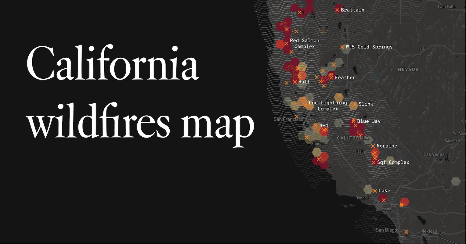
California Fire Map: Active Wildfires
A map of wildfires currently burning in California
www.latimes.com
The most recent fire is the 3-4 fire, which started on Aug. 19. It is 0% contained and has burned 1,000 acres so far.
The largest active fire is the Ohlone fire, which has burned 97,092 acres so far. It started on Aug. 16 and is 0% contained.
This map is interactive -41 California fires-
Ohlone CA 97,092 acres burned Burning for 3 days
Scu Lightning Complex CA 85,000 acres burned Burning for 1 day 5%
Lnu Lightning Complex CA 46,225 acres burned Burning for 1 day 0%
Apple CA 33,424 acres burned Burning for 19 days 95%
Lake CA 25,948 acres burned Burning for 7 days 38%
Red Salmon Complex CA 15,497 acres burned Burning for 1 day 38%
River CA 10,672 acres burned Burning for 3 days 7%
Czu August Lightning Complex CA 10,000 acres burned Burning for 2 days 0%
North Complex CA 5,400 acres burned Burning for 1 day 5%
Beach CA 3,780 acres burned Burning for 2 days 80%
Holser CA 3,000 acres burned Burning for 2 days 30%
Hills CA 1,500 acres burned Burning for 4 days 35%
Butte Lightning Complex CA 1,500 acres burned Burning for 2 days 10%
Salt CA 1,500 acres burned Burning for 1 day 10%
Carmel CA 1,200 acres burned Burning for 1 day 0%
3-4 CA 1,000 acres burned Started today 0%
Potters CA 930 acres burned Burning for 1 day 20%
Jones CA 675 acres burned Burning for 2 days 5%
Claremont CA 650 acres burned Burning for 1 day
R-5 CA 471 acres burned Burning for 2 days 75%
4-8 CA 250 acres burned Burning for 2 days 90%
Whale CA 210 acres burned Burning for 4 days 65%
Elsmere CA 200 acres burned Burning for 16 days 30%
Warnella CA 167 acres burned Burning for 3 days
Bluejay CA 155 acres burned Burning for 25 days
3-19 CA 62 acres burned Burning for 1 day 40%
Bell CA 20 acres burned Burning for 1 day
Murphy CA 14 acres burned Burning for 2 days 80%
Wolf CA 3 acres burned Burning for 8 days
Ranch CA Burning for 6 days
Feather CA Burning for 6 days
Loyalton CA Burning for 5 days
August Complex CA Burning for 3 days
Shf Lightnings 2020 CA Burning for 1 day
Blue Jay CA Burning for 1 day
Dolan CA Started today
13-4 CA Burning for 1 day
20 other fires within other states
Pine Gulch CO 93,331 acres burned Burning for 19 days 7% contained
Taylor Pond WA 37,375 acres burned Burning for 2 days 75%
Grizzly Creek CO 29,402 acres burned Burning for 9 days 4%
Indian Creek OR 20,361 acres burned Burning for 3 days
Cameron Peak CO 15,748 acres burned Burning for 6 days
Bear Creek MT 7,542 acres burned Burning for 8 days 10%
Williams Fork CO 6,729 acres burned Burning for 5 days 3%
Wildcat OR 3,458 acres burned Burning for 2 days
Crane OR 2,270 acres burned Burning for 3 days 5%
Mosier Creek OR 997 acres burned Burning for 7 days 65%
Elder AZ 739 acres burned Burning for 3 days
Badger Lake WA 266 acres burned Burning for 2 days 40%
P515 OR 242 acres burned Burning for 3 days
Green Ridge OR 150 acres burned Burning for 2 days
Spud Rock AZ 25 acres burned Burning for 6 days
Mica Bowl AZ 8 acres burned Burning for 5 days
Hatchett - Prairie MT 2 acres burned Burning for 10 days
Graves Creek OR 1 acres burned Burning for 2 days
Steinmetz Creek OR Burning for 4 days
Zero - Prairie MT Burning for 18 days
Lightning Complex Fires trigger evacuation of 30,000 in Sonoma County
Updated 2 hours ago
SONOMA COUNTY, Calif. (KGO) -- The 13-4 Fire turned towards northwest Sonoma County triggering the evacuation for 30,000 residents.
The fire is burning west of Healdsburg near the Austin Creek State Recreation Area.
The blaze is part of three main fires now being called the LNU Lightning Complex Fires.
Cal Fire is encouraging people to follow orders:
"Residents that are in the evacuation order area we hope have heeded to those warnings and moved out of the area especially in those rural remote single-lane windy roads. We need those individuals evacuated and out of the area so our firefighters can move in and out easily and not have to worry about oncoming traffic," said Paul Lowenthal, Cal Fire.
Cal Fire says the 13-4 Fire has burned at least 500 acres and there is no containment.
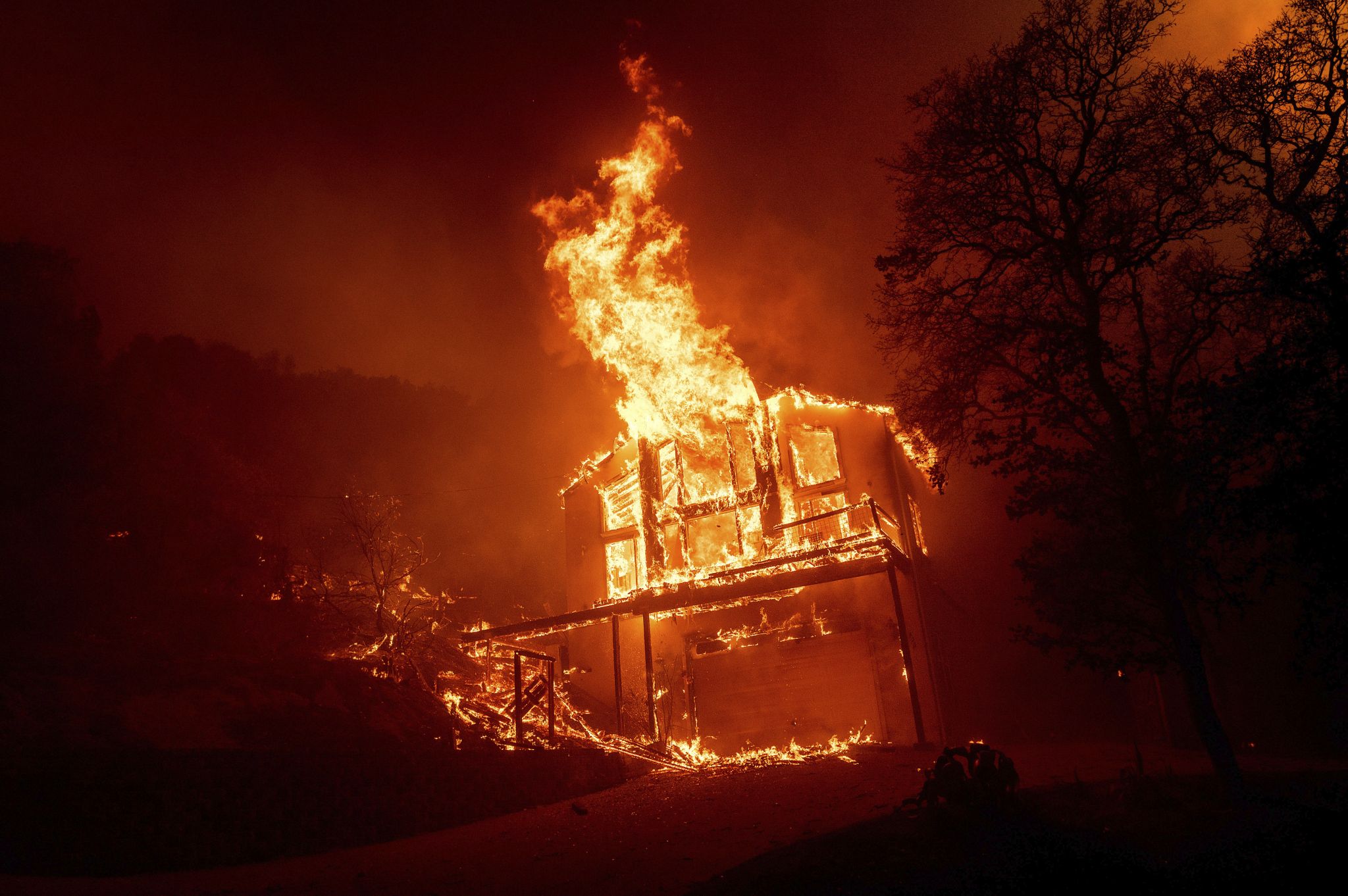
California wildfires destroy homes, prompt evacuations from Vacaville to Santa Cruz
Published 6 hours ago
VACAVILLE, Calif. - Thousands of people were under orders to evacuate broad areas of Northern California Wednesday as some 30 wildfires blazed across the state amid a blistering heat wave now in its second week.
“Throughout the state of California right now, we are stretched thin for crews” because of the fires, said Will Powers, a state fire spokesman. “Air resources have been stretched thin throughout the whole state.”
Thousands of homes and businesses were threatened in the wine-growing counties of Napa and Sonoma in an area devastated by a series of deadly blazes in the last three years. At least seven fires were grouped together as one of two major Lightning Fires in Northern California, a nod to their origins just a day earlier.
By Wednesday, the LNU fires had burned 50 square miles and was 0% contained. To put that in perspective, that’s about the size of the entire city of Vallejo.
Authorities issued several evacuation orders in Napa, Sonoma and Solano counties. Christa Haefner had to evacuate.
"More than anything we’re worried about our animals," she said. "They don’t handle stress well."
Fire officials warned of “extreme fire behavior” challenging firefighters there, including strong winds. Powers said much of the fire was burning through rural areas with steep terrain, making it difficult to get crews in. Wednesday's weather wasn't going to help. Temperatures were expected to soar past 100 degrees in many inland spots.
Skipping Down
To the south, evacuations were ordered for all of Boulder Creek to the west of Silicon Valley, a community of 5,000 high in the Santa Cruz mountains where windy, long, forested roads, some paved, some dirt, can easily become blocked during storms or fires.
That fire is being called the CZU fire and was burning across both San Mateo and Santa Cruz counties. Evacuations were ordered there too. As of Wednesday morning, the fire had burned 7,500 acres.
Cal Fire spokesman Jonathan Cox said that the fires were actually 22 smaller blazes merged togther.
"It's a very active timber fire," Cox said. "And a very serious threat to public safety."
As of Wednesday morning, the CZU Fire had burned 10,000 acres and 22,000 people had been evacuated in San Mateo and Santa Cruz counties. On Tuesday, Gov. Gavin Newsom ordered a statewide state of emergency.
Hennessey Fire: Evacuations ordered in Vacaville as blaze explodes overnight
Updated 16 minutes ago Snip:
The Hennessey fire is now moving toward Vacaville and people are being ordered to evacuate after it exploded in size overnight.
The evacuation orders were issued for Solano County residents west of Blue Ridge Road to Interstate 505 and north of Cherry Glenn Road Highway 128. People on Pleasants Valley Road are also being told to leave. Earlier evacuations were advised for the Quail Canyon, Miller Canyon, Mix Canyon and Gates Canyon areas. The fire is part of the LNU Lightning Complex which has burned more than 32,000 acres and is zero percent contained. Officials say 2,000 to 3,000 homes are threatened by the fire.
Evacuation Centers have been opened in Vacaville this morning. The Ulatis Community Center and McBride Community Center have been opened for residents forced to evacuate. Large animals can be take to the Solano County Fairgrounds in Vallejo. And small animals can be dropped off at the Solano County animal shelter on Claybank Road.
The Hennessey fire is now moving toward Vacaville and people are being ordered to evacuate after it exploded in size overnight.
The evacuation orders were issued for Solano County residents west of Blue Ridge Road to Interstate 505 and north of Cherry Glenn Road Highway 128. People on Pleasants Valley Road are also being told to leave. Earlier evacuations were advised for the Quail Canyon, Miller Canyon, Mix Canyon and Gates Canyon areas. The fire is part of the LNU Lightning Complex which has burned more than 32,000 acres and is zero percent contained. Officials say 2,000 to 3,000 homes are threatened by the fire.
According to CAL FIRE, the Hennessey Fire was caused by lightning as thunderstorms moved through the Bay Area on Monday.
North Bay fires rage, Angwin and St. Helena Hospital ordered to evacuate
Multiple wildfires are burning in Napa and Sonoma counties. Cal Fire is referring to them...

CBS Bay Area - Breaking Local News, First Alert Weather & Sports
Latest breaking news from KPIX-TV CBS Bay Area.
 sanfrancisco.cbslocal.com
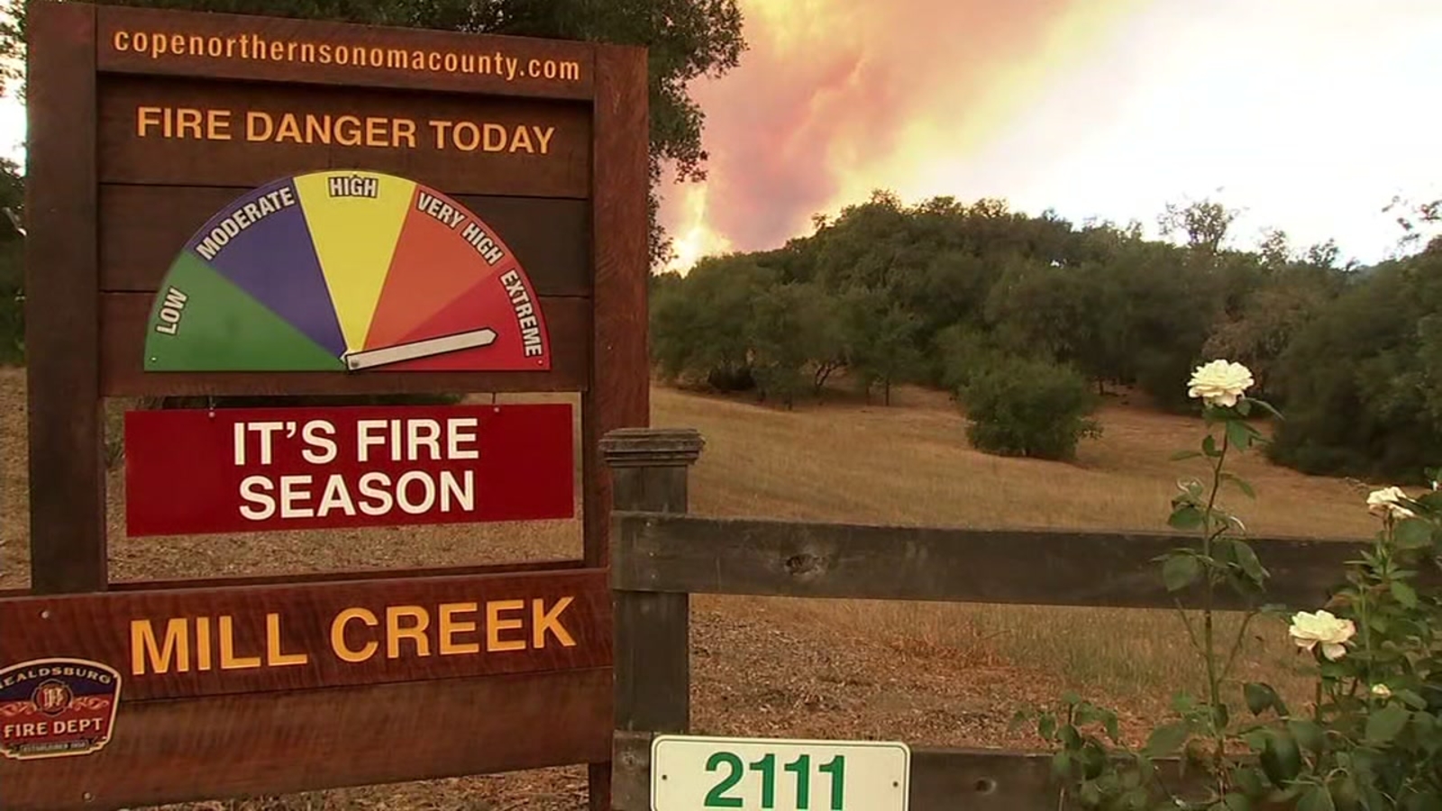
Walbridge Fire: Evacuation warning issued for entire city of Healdsburg
The Walbridge Fire burning in western Sonoma County grew from 1,500 acres to now over 14,000 acres, prompting an evacuation warning for all residents in Healdsburg.
HEALDSBURG, Calif. (KGO) -- Today the Walbridge Fire burning in western Sonoma County grew from 1,500 acres to now over 14,000 acres, prompting an evacuation warning for all residents in Healdsburg.
The city of Healdsburg issued an evacuation warning for the entire city after 8 p.m Wednesday where they stated "Our goal is to increase your state of readiness, not to frighten you."
INTERACTIVE MAP: Track wildfires across Bay Area, other parts of CA
Healdsburg residents we spoke with off Old Redwood Highway are packing up in-case the warning turns into an order.
Misty Mathews is a registered nurse at Sutter, she was loading up her SUV.
"So just trying to get ready, we kind of waited till the last minute last year and kind of learned our lessons so getting everything ready now," Mathews said.
VIDEO: Video shows terrifying escape through flames of LNU Lightning Complex fires
Down the road, longtime resident Bertha Vieyra already had her suitcase loaded in her car.
"My purse and my tote bag is right there ready for me to grab- get my keys and get in the car and go where I have to go," Vieyra said.
Vieyra said she's not too worried about the fires. "I feel comfortable because I get the warnings and that makes me feel safe. But you know what, I think we're going to be ok," Vieyra said.
RELATED: Lightning Complex Fires trigger evacuation of 30,000 in Sonoma County; 10-4 Fire at 1,500 acres
Residents near Mill Creek Road and Puccioni Road are under an evacuation order. Paul Huillade said he's been dealing with wildfires his whole life- he's not going anywhere until he absolutely has to.
"I was originally from Cazadero and we don't leave- you fight for what you have. So."
Huillade is part of a group text with his neighbors that have decided if they have to leave- they'll do it together.
"When we leave we're going to go out in a little herd. It's a waiting game now- yeah. If it comes this way- do what you gotta do," Huillade said.
The city of Healdsburg is asking residents to be ready to leave, do not wait to starting gathering belongings.
Thanks for your coverage of the California fires.
NASA has a good tool to get a sense of the scale of these fires: NASA FIRMS
Another good map: National Fire Situational Awareness
Trending content
-

-

-
Thread 'Coronavirus Pandemic: Apocalypse Now! Or exaggerated scare story?'
- wanderingthomas
Replies: 30K -
