Great tweet. "Left: In 2006, Al Gore predicts there will be no more snow on Mount Kilimanjaro in 2020. Right: 2020."
You are using an out of date browser. It may not display this or other websites correctly.
You should upgrade or use an alternative browser.
You should upgrade or use an alternative browser.
The Ice Age Cometh! Forget Global Warming!
- Thread starter Gaby
- Start date
Spain: More than 100 roads impassable due to rainfall and storm
Spain: 350 evacuated after the winter attack; snow plough driver dead
More than 100 roads in Spain were impassable on Saturday due to heavy snow and rainfall and strong winds. The collapse of the weather has led to several towns in the north of the country being cut off from the world and ports being closed.
According to estimates by the General Directorate for Road Traffic (DGT), the most difficult conditions are in the north of Spain, particularly in Asturias, the Basque Country, Cantabria and Navarre.
In the afternoon, the civil protection services managed to clear the route leading to Somiedo, in the Autonomous Community of Asturias. At night, a rock wall broke down there, which blocked the road. Heavy equipment had to be used.
Also in the vicinity of the port of Mutriku, in the Basque Country, after the passage of the storm, rock chips and tree branches fell on the road.
In the vicinity of the towns of Eibar and Bilbao, in the north of Spain, traffic was stopped on national roads due to accidents involving heavy goods vehicles that slipped on an icy roadway.
On several dozen Spanish routes, especially in the north, traffic is stopped on Saturday due to heavy snowfall. Where the services have managed to clear the road, driving is possible by putting chains on wheels.
By Saturday afternoon, due to high waves, reaching up to 8 metres, several seaports on the north coast of Spain were closed until the storm stops.
Spain: 350 evacuated after the winter attack; snow plough driver dead
Some 350 people were evacuated on Saturday afternoon from the Guadarrama mountain range near Madrid due to a sudden deterioration in the weather. Meanwhile, in Asturias, in the north of Spain, the civil protection services found the body of a snowplough driver who had been hit by an avalanche.
On the night of Saturday to Sunday, nearly 80 rescuers were searching for the other worker, who was in the snow plough when the avalanche descended.
Since Friday evening, the Autonomous Community of Asturias has been one of the most experienced by the snow blizzard and temperature drop.
On Saturday afternoon, the civil protection services directed coaches and ambulances to evacuate 350 people, mainly tourists, from the ski lift and Navacerrada lookout point in the Guadarrama mountain range near Madrid.
Due to the heavy snowfall and the limited number of buses they could not get out of this popular place of winter excursions. More than 150 people needed medical help because of the cold. The temperature there dropped to -10 degrees Celsius.
On Saturday, more than 100 roads were impassable due to the snow on the road, as well as broken tree branches and landslides throughout Spain, most of which were in the northern part of the country, mainly Asturias, Cantabria and the Basque Country.
By evening, due to the high waves on the northern coast of Spain, several seaports had been permanently or temporarily closed until the storm stopped.
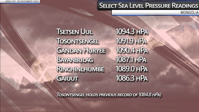
All-time pressure records set at the end of 2020: North Pacific extratropical storm peaks at 921 mbar, extreme cold in Mongolia sets new world record with 1094 mbar
We have seen the year 2020 was, weatherwise, a remarkable and deadly year by various extreme weather events. Including the record-breaking Atlantic hurricane season, wildfires in Siberia, and winter storms in both Europe and the United States. And the year ended with a bang, setting a new North Pacific low-pressure record of 921 mbar as a powerful extratropical storm hit Alaska on the last day of 2020. While just a day earlier, a new world record for high-pressure has been set in Mongolia, 1094 mbar!
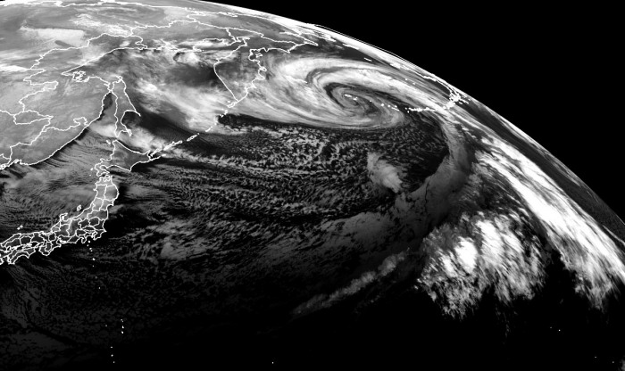
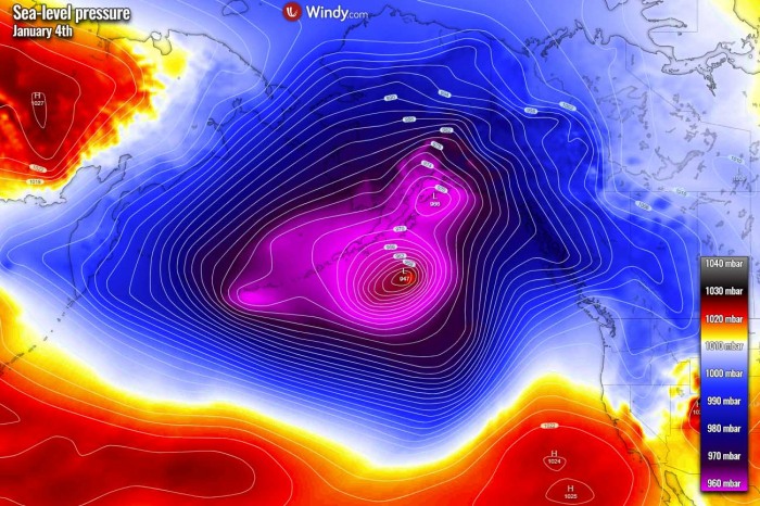
As we have been writing about in our initial Wednesday’s discussion regarding the potential record-breaking evolution of this storm, the North Pacific, Alaska, and the Bering Sea have set a new record for the lowest central pressure of an extratropical storm. The lowest central pressure with this storm was 921 mbar over the North Pacific on the last day of 2020, Dec 31st.
While the center of the low crossed the Aleutian Islands, the nearest weather station Shemya island of the Alaska weather station network recorded 924.8 mbar, breaking the previous record of 926 mbar set at Dutch Harbor on October 25th, 1977.
When the system moved into the Bering Sea, it also set a new minimum central pressure of 921 mbar, becoming the deepest storm in the Bering Sea on record. The last storm with so deep pressure were remnants of Super Typhoon Nuri.
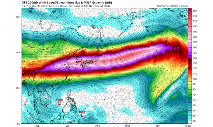
The North Pacific hardly sees any rest this winter and this storm was no exception for the region. A combination of the deep Arctic cold over Siberia, the advection of a warm Pacific tropical air mass, and the extremely powerful 250 mph jet stream between these two air masses have resulted in a very *explosive* development of an extratropical storm and bottom out at 921 mbar, right in the time the storm was about to cross the Aleutian Islands.
There were many intense mid-latitude cyclones (extratropical lows) lately and North Pacific is showing no signs of easing off anytime soon. More storms are on the way in the coming days, including a potentially very dangerous extratropical storm nearing Alaska mainland and Southeast Alaska this new week.
The extreme cold over parts of Asia mentioned earlier above, has also set another extreme record for air pressure – a world record for the highest sea-level pressure! The Mongolian weather station Tsetsen-Uul’s mean sea-level pressure rose to an unprecedented 1094.3 mbar (or 32.31 inches). This broke the previous record of 1089.4 mbar set on Dec 30th, 2004 at the same station.
Let’s see how the storm evolved in the final days of 2020, which has led its central pressure to become the lowest on record for the North Pacific Ocean, Alaska, and the Bearing Sea.
FROM JAPAN TO BERING SEA IN TWO DAYS
The deep Arctic air, originating over Siberia, has met a tropical air mass being advected from the Western Pacific warm pool. Ocean sea surface temperatures there are normally at around 30 °C year-round. A very extreme temperature gradient took shape in between them with a very powerful jet stream in the upper troposphere (110 m/s at 200-300 mbar) separating the two air masses.
And the geography of Central/Eastern Asia favored the merging of the otherwise mostly separated polar and subtropical jet streams. The cyclone has formed in a region of a very favorable upper-level divergence, underneath a combined left exit and right entrance regime of two upper-level jet streams. The interaction with the strengthening upstream jet streak resulted in the surface low’s further deepening.
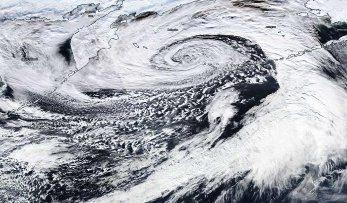
The low has formed near Japan on Tuesday and has been deepening steadily but rapidly strengthening through Wednesday when an explosive intensification started as a much faster pressure falls rate, while the storm was moving to the south of the Kamchatka Peninsula. The system headed straight for the Aleutian Islands and the Bering Sea for the last day of the year, right for New Year’s Eve 2020. It grazed across the westernmost islands of the Aleutians with extremely powerful, life-threatening hurricane-force winds and major destructive waves.
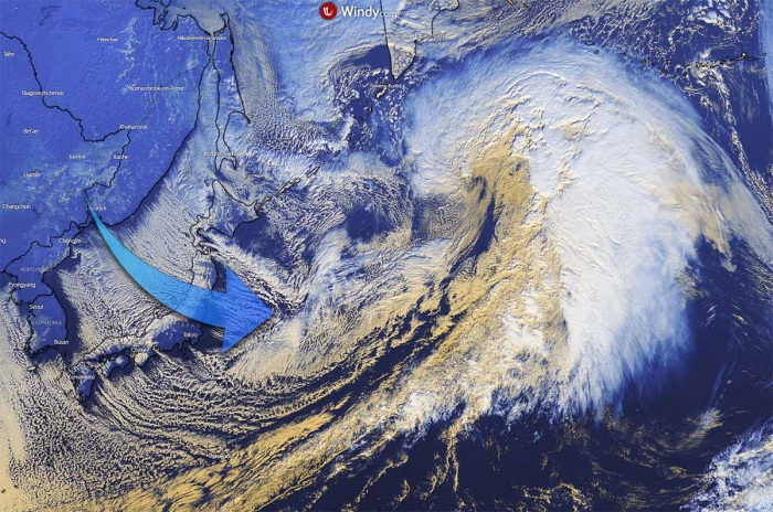
The background effect leading to this storm’s evolution and its explosive development was an impressive, extremely cold with below -55 °C spread across parts of Siberia, Russia after Christmas. The advection of this cold air mass was rushing eastward across Japan and the Northwest Pacific Ocean, dumping around a meter of fresh snow across the main, central Japan island. As this deep and extreme cold Arctic air mass interacted with the strong Pacific jet stream, the result was a very *explosive* nature of the storm’s rapid intensification.
The pressure falls of nearly 60 mbar per 24 hours and 75 mbar per 36 hours were also very near or even a record-breaking pressure changes in the North Pacific basin.
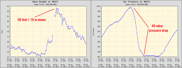
The extratropical storm brought a broad area of hurricane-force 85+ mph winds to most of the waters west of Unalaska and the Pribilof Islands beginning Wednesday evening through Friday. In addition to hurricane-strength winds, this monster storm generated significant wave heights, with a potentially record-breaking height of 58 feet (almost 18 meters) on the Pacific side of the Aleutians from Adak to Attu Island on Thursday. Such waves are destructive when they hit the coast.
The system took almost the same track as the intense extratropical storm last weekend, which bottomed out at 939 mbar on Sunday, Dec 27th. It blasted across the southwestern portions of the Aleutian Islands with extremely powerful winds and very significant, 55+ feet waves.
This low has also become the most intense Earth’s storm of the year!
EXTREME 75 mbar PRESSURE DROP IN 36 HOURS
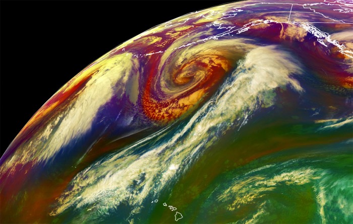
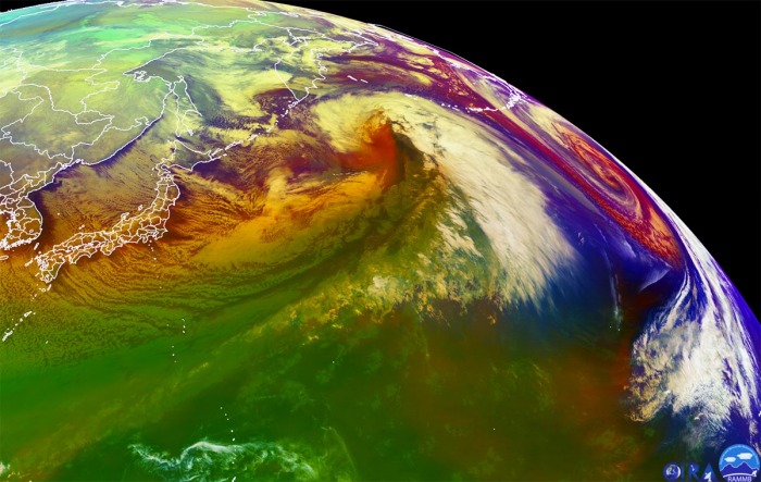
When moving south of the Kamchatka peninsula, the low has deepened to 960 mbar as of 18 UTC Wednesday (local morning), with a deeping pressure of around 10-15 mbar per 6 hours period. The system was already an impressive monster storm by then. There was a textbook appearance of an explosively strengthening extratropical storm, as seen by the airmass satellite scan below. With a well-defined dry intrusion visible, being pushed into the storm from the southwest.
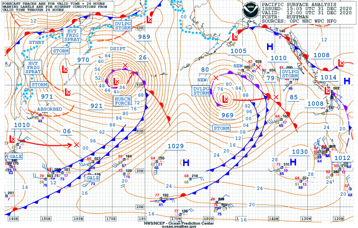
The surface pressure analysis below reveals this extratropical storm evolution from its birth near Japan on Tuesday, Dec 29th, entering the explosive intensification while gradually growing its size and rapidly lowering its central pressure through Wednesday. Then, it deepens considerably on Thursday when the peak, lowest central pressure, has been reached in the morning hours (local Pacific/Alaska time):
As we can see from the pressure analysis above, the central pressure in this extratropical storm had an *EXTREME* 75 mbar pressure fall over the 36-hour period (from 996 mbar to 921 mbar) between Wednesday, Dec 30th 00 UTC and Thursday, Dec 31st 12 UTC. This is very likely also near or even a record-setting pressure change for the basin. The largest pressure change within a period of 24 hours was a remarkable 58 mbar pressure fall between Dec 30th 06 UTC and Dec 31st 06 UTC (from 986 mbar to 928 mbar).
- 923 mbar at 00 UTC, Jan 1st
- 921 mbar at 18 UTC, Dec 31st
- 921 mbar at 12 UTC, Dec 31st
- 928 mbar at 06 UTC, Dec 31st
- 941 mbar at 00 UTC, Dec 31st
- 960 mbar at 18 UTC, Dec 30th
- 972 mbar at 12 UTC, Dec 30th
- 986 mbar at 06 UTC, Dec 30th
- 996 mbar at 00 UTC, Dec 30th
- 1001 mbar at 18 UTC, Dec 29th
- 1008 mbar at 12 UTC, Dec 29th
Here is the OPC NOAA pressure analysis across the North Pacific at the time of the peak intensity on Thursday morning. Notice there was also another strong system to its east.
Its rapid intensification rate was so explosive, that its central pressure fall was more than double the threshold for a bomb cyclone*.
*Bomb cyclone or a bombogenesis is a meteorological term that describes a mid-latitude cyclone (a so-called extratropical low or storm) that rapidly intensifies. Both with winds and indeed its central pressure.
The bombogenesis process occurs when an extratropical storm rapidly intensifies, dropping its central pressure at least 24 millibars over 24 hours period. A millibar measures atmospheric pressure. This can happen when a cold air mass collides with a warm air mass, such as air over warm ocean waters, and leads to an explosive strengthening of the storm.
The formation of this rapidly strengthening weather system is a process called bombogenesis, which creates what is known as a bomb cyclone.
As the National Weather Service in Anchorage, Alaska has tweeted on Friday, a new Alaska land-based low-pressure record has been set! The mean sea-level pressure at the Shemya Islands dropped to 924.8 mbar at 22 UTC (local 1 pm Alaska time). The previously accepted record was from a ship in Dutch Harbor at 925 mbar, measured in 1977.
The storm’s hurricane-force winds and significantly high waves have also lead to remarkable wave heights at the oceanic NOAA buoy #46071, located on the Pacific side of Amchitka Island, Alaska. The highest wave height was reported at 58.1 feet. That is 17.7 meters!
The strongest wind gusts recorded at Shemya Island were up to 83 mph (133 km/h) in the hours prior the record-breaking pressure readings were set.
NEW WORLD RECORD FOR HIGHEST PRESSURE IN MONGOLIA
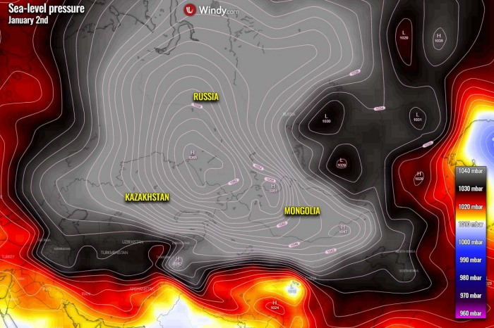
But there was also another remarkable effect of the extreme cold over Russia. As it typically occurs during very cold temperatures, the denser, cold air sinks and result in the surface high-pressure rising into very high values. This has happened also this week over central Asia and pushed the barometers into some unprecedented values.
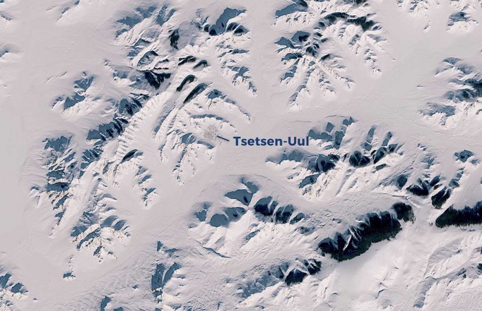
Actually, a new world record for the highest mean sea-level pressure has likely been set in a high mountain valley (plateau) in Mongolia, central Asia. An automatic weather station located in Tsetsen-Uul, western Zavkhan province, Mongolia has recorded a mean sea-level pressure of 1094.3 mbar along with bitter temperatures of -45.5 °C (-50 °F).
Image is provided by Windy.com
Three other weather stations have also reported pressure reading higher than the existing pressure record from 2004, so the records from Tsetsen-Uul aren’t just a reading error or a transmission error. If these records will be verified, it will break the previous world record of 1089.4 mbar also set in Mongolia, exactly 16 years ago.
According to the World Meteorological Organization (WMO), the previous highest pressure reading was set at two stations, both in Mongolia. Weather station Tsetsen-Uul and Tosontsengel have both recorded pressure of 1089.1 mbar (1089.4 mbar if using Russian method) on December 30th, 2004. It has to be noted that Tosontsengel’s elevation is 1725 meters (5658 feet) above sea-level while Tsetsen-Uul’s elevation is 1928 meters (or 6325 feet) above sea-level. These are high mountain valleys on the plateau.
On 30 December 2004 in Tosontsengel Mongolia, at 2 am local time on the 30th, (18/1800 UTC) the station pressure rose to 846.5 hPa. Using the supplied station pressure of 846.5 hPa, a geopotential height of 1725.8 m and an ambient air temperature of -44.8 ºC, the WMO method for reduction to sea level pressure produces an adjusted sea level pressure value of 1089.1 mbar.
See more details in the WMO article here: The Tosontsengel Mongolia world record sea‐level pressure extreme: a spatial analysis of elevation bias in adjustment‐to‐sea‐level pressures
It is for now still an unofficial value, as WMO has normally taken time for deep analysis of the environment. But it is also interesting to see that the surface temperature of around -45 °C (-49 °F) at Tsetsen-Uul at the time of the peak surface pressure records was close to those readings from the day the previous record was set, -44.8 °C (-48.6 °F). This is very important information as it gives the 2020 readings a good potential to be confirmed by the analysis later.
For your reference; According to the meteorologist Bob Henson, the highest sea-level pressure ever recorded in the United States mainland is 1078.8 mbar, set in Northway, Alaska on January 31st, 1989. The Canadian record was set two days later, on February 2nd, when 1079.6 mbar pressure readings were recorded at Dawson City, Yukon.
Image is provided by Windy.com
Note: The highest values of the mean sea-level pressure normally occur in frigid winter months with snow on the ground, as dense air sinks towards the surface, e.g. in the valleys. When the night skies are clear and strong temperature inversion forms, almost no wind is present which helps the cooling air to sink towards the bottom of the valley and become even colderm as it doesn’t mix with the lack of winds. And the temperatures are much lower in the bottom of the valley than it is along the surrounding slopes.
BRUTAL COLD OVER SIBERIA
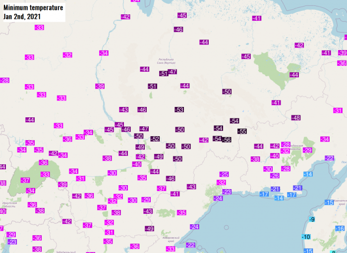
The infamous Russian frigid cold town of Ojmjakon and surrounding towns Nera, Delyankir, Yurty, and Agayakan were lately reporting morning temperatures of around -55 °C (-67 °F) and were definitely a huge factor leading to the evolution of the explosive extratropical storm over the Northwest Pacific Ocean. The advection of Arctic cold air mass has also introduced an intense sea-effect snowfall from the Sea of Japan into Japan’s main island Honshu. Locally more than 3 feet (1-meter or 100 cm) of snow has been reported there.
Although the Russian region of Siberia is indeed used to frigid cold temperatures during the winter months, temperatures below -55 °C are still very extreme there! Attached below are the morning temperatures in Ojmjakon and Delyankir over the last 30 days. We can see that the extreme cold has become even more intense after Christmas, and it continues into January 2021.
MORE INTENSE STORMS HEADING FOR ALASKA THIS WEEK
The overall very active pattern across the North Pacific continues, so new extratropical storms are expected in the coming week. The largest storm is likely to arrive on Tuesday and would potentially be quite intense. The ECMWF model guidance suggests that its central pressure would push even below 950 mbar while the storm will be moving with its center just south of the Aleutian Islands towards the Gulf of Alaska.
Image is provided by Windy.com
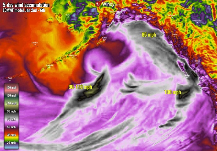
This new extratropical storm is then forecast to move closer to the Alaska mainland and gradually losing its strength through the mid-week days. As its development will be quite rapid again on Sunday into Monday, it will likely form violent, hurricane-force winds to the south of its core. Peak gusts up to 110 mph seem possible there.
Image is provided by Windy.com
The whole circulation over the far North Pacific and the Gulf of Alaska will be huge and the pressure gradient quite significant. This will help the overall windy conditions to become severe. Another wave with a small but intense surface low will push towards Southeast Alaska already on Monday and could bring violent winds and high waves to the southern portions of the region and the Pacific Northwest.
It should bring another 4-8 inches of precipitation further inland into the mountains, and indeed huge snowpack with potentially additional 50-80 inches of new snow over the next five days.
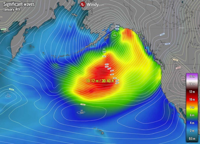
Image is provided by Windy.com
Violent winds associated with this Monday’s low and the new large storm on Tuesday will generate significant waves of 8-12 meters towards the coast of Southeast Alaska and the Pacific Northwest of western Canada and the United States.
We will be posting further updates in the coming days, stay tuned!
Were getting hammered by the current deep freeze underway in Europe!Spain: More than 100 roads impassable due to rainfall and storm
#Espagne from tomorrow with 20 to 50 cm expected, including in the plains and in the region of #Madrid . This deterioration could temporarily affect the south of France but the risk seems more limited than initially envisaged ...
Weather It's still gray and cold @GWoznica takes you under the Northern Lights of Lapland with @LCI
Spain: Record low temperature; at least one person died as a result of the winter attack
A significant winter storm with a lot of snow will strike Spain from Thursday through Saturday, storms with heavy rain and flooding for Gibraltar
At least one person died on Thursday as a result of the winter attack in Spain. The north-western part of the country recorded a record low air temperature - minus 35.6 degrees Celsius.
The coldest place in Spanish history was the Vega de Liordes weather station in the province of Leon. It is situated at an altitude of 1872 m above sea level.
The previously unheard of temperature is the second record of cold in Spain in the last 24 hours. On Wednesday morning the thermometer at the meteorological station in the Catalan town of Clot de la Llanca showed minus 34.1 degrees Celsius.
The winter attack led to the death of a man in Paso Cortes de Aragon de Calatayud, in the north-east. According to information from the medical services, the probable cause of death of the over 30 year old man was the cooling of his body while he was away from home.
On Thursday, in Asturias, the search resumed for a worker helping to clear one of the regional roads, who was kidnapped by an avalanche at the weekend. The emergency services are using a drone with a radar brought from Latvia.
On Thursday afternoon, very difficult weather conditions prevailed in almost the whole of Spain, which led to serious traffic difficulties. According to estimates by the Central Directorate for Road Transport (DGT), there are already more than 160 national roads blocked due to snow on the roadway.
Among the impassable routes are three motorways: the A-4 and A-40, which run through central Spain, and the A-7, which links Barcelona with Malaga.
A significant winter storm with a lot of snow will strike Spain from Thursday through Saturday, storms with heavy rain and flooding for Gibraltar
The overall pattern established over Europe favors cold weather in many parts of our continent, especially across the southwestern Europe. Starting this Thursday, a significant winter storm will hit Spain. A huge amount of snow is expected across the eastern half of the country, likely with more than 50 cm of fresh snow in many areas over the next 3 days. Storms, including severe, with heavy rain and flooding, will hit Gibraltar and Andalusia, southern Spain.
It has been quite an interesting weather pattern across Europe through December and over the holidays. Lately, a winter storm hit the Alpine region again. Remember the region was severely hit with massive rains, flooding and extreme snow in early December 2020. The snow depth was going into a few meters. And then, another significant winter storm hit over the holidays, bringing snow accumulation even higher.
The general weather circulation over our continent this January is a rather classic negative NAO (North Atlantic Oscillation) pattern, meaning there is higher pressure over the North Atlantic (blocking high) with more active waves from the Azores into the southern portions of the European continent. This is resulting in a progressive pattern with frontal systems traveling within this broad channel over the Iberian peninsula, Mediterranean, and further northeast into the Balkan peninsula.
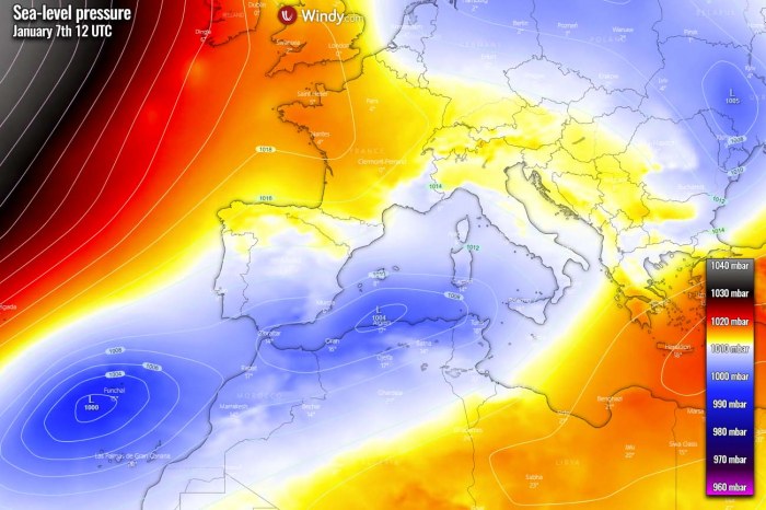
Now, the model guidance trends are turning for a winter storm to develop over the Iberian peninsula (Spain) today, with another more significant storm arriving on Saturday. So the next three days will bring wintery weather for a large part of Spain, and could locally result in very high snow accumulation. Attached below is the video animation of the pattern evolution across southwestern Europe, including the pressure forecast, temperature, and snow accumulation evolution into the coming weekend.
We will now take a deep, more detailed look over the developing pattern across North Atlantic and Europe, as well as across the Iberian peninsula for the rest of this week. In general, blocked Atlantic vs. active weather across the European continent. The next in line to receive a lot of snow is Spain, then the next could be the Balkan peninsula towards the end of the weekend.
NEGATIVE NAO PHASE PATTERN
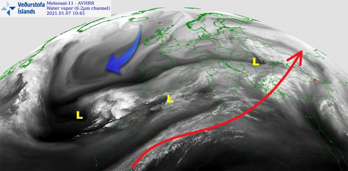
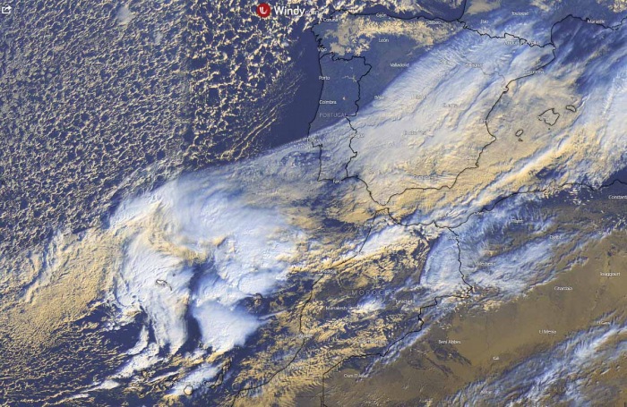
As said earlier, the general weather pattern across North Atlantic and Europe depict a negative North Atlantic Oscillation (NAO) with blocking ridge and a high-pressure system over the North Atlantic. While to the south, lower pressure is spread from the Azores where upper waves are moving from west to east across the southern parts of Europe and the Mediterranean. As we could see from the water vapor satellite above, a cold advection is spreading across the Atlantic towards the deep south, reaching the Azores and southwestern Europe.
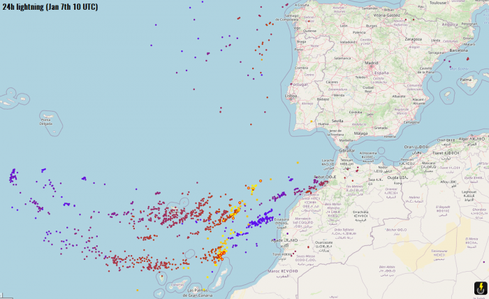
A new wave has developed over the Azores in mid this week, gradually strengthening while moving towards southwestern Europe (Portugal and Spain) and Morocco. While the baroclinic zone is being spread across southern Spain and the western Mediterranean this Thursday, the core of the incoming wave is creating quite a lot of deep convection near the Azores. A rather impressive amount of lightning activity has been observed there as well. Image is provided by Windy.com
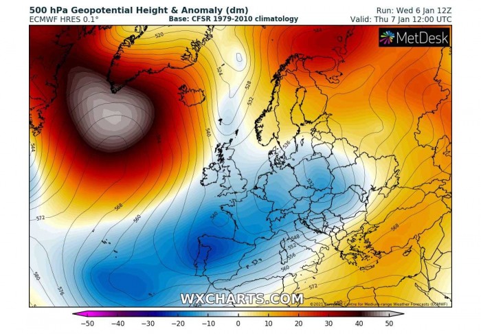
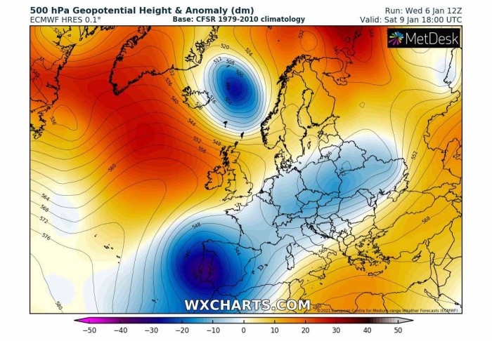
If we take a look over the 500 mbar charts, the positive NAO phase is obvious – a powerful upper-level ridge over the North Atlantic while lower geopotential heights further south, from the Azores into southwestern and central Europe. Chart hints there are three waves easily visible; one above Slovakia, the second one above Iberia, and this new one south of the Azores. The latter is the main focus now, as it is expected to produce a massive winter storm in Spain over the next three days.
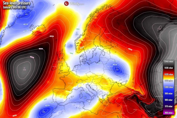
The surface pressure analysis this Thursday is indeed well-correlated with the upper-level pattern. An extensive blocking high-pressure system is over the North Atlantic, while another strong ridge is further east of Russia and northern Europe. The lower pressure is actually trapped in between these systems, and today’s picture reveals three surface lows. One is west of Morocco, another one is traveling over the Mediterranean while the third one is ejecting eastern Ukraine. The Mediterranean low will develop a winter storm over the Balkans tomorrow, on Friday. Image is provided by Windy.com
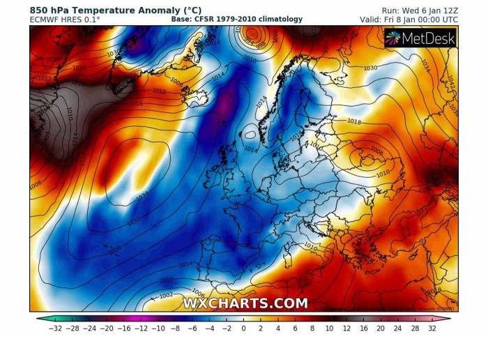
This circulation is spreading a colder airmass over the Atlantic far south, actually quite easy as the flow is more or less straight meridional from the north. This 850 mbar temperature anomaly chart hints below-average temperatures are spread over the western and central parts of Europe, as well as over southwestern Europe. Fits well with the northerly flow to the east of the upper High, advecting air mass from the Arctic region across western Europe towards the Azores.
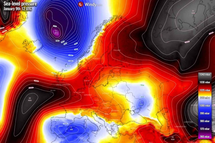
If we take a brief look at what is shaping up for the weekend, the general pattern will not change much. However, there is one obvious featured system – a very deep upper core moving into the Iberian peninsula. It will develop a significant winter storm into Spain on Saturday. Further north, a strong upper-level ridge remains over the North Atlantic, with another upper low moving towards Scandinavia on its eastern flank. And we must not ignore the wave moving across central Europe, it will likely develop another winter storm for the Balkan peninsula on Sunday.
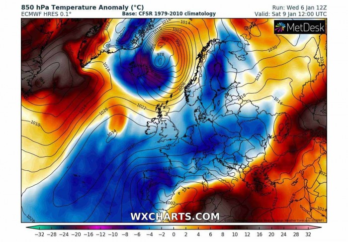
With the arrival of the deep upper low into southwestern Europe, an associated surface low will be moving across the southern Iberian peninsula and re-strengthen over the western Mediterranean. And the flow from the east will increase moisture into eastern portions of Spain. In other words, this means stronger precipitation, including heavy rain and snow. The new wave to the east of Iceland is also well-visible with a very deep surface low and tight pressure gradient to its west. Image is provided by Windy.com
The overall temperature picture across Europe and North Atlantic over the weekend remain similar, cold advection is spread across much of our continent. But take a look at a rather extreme Arctic blast associated with the new upper low near Iceland. Much below normal temperatures spread over the country on Saturday, continue south-southeast on Sunday. The low over the western Mediterranean will help the cold to maintain over Portugal and Spain, with strong warm advection into the southern Mediterranean ahead of it.
So in general, the conditions over Europe are actually quite well established for potential winter weather to develop. Indeed depends on the frontal system tracks across the continent. This time it is the Iberian and the Balkan peninsula, more waves next week could also bring snow into other parts of Europe. Keep in mind we’re under a transforming pattern now, as the polar vortex collapsed and a significant sudden stratospheric warming event is underway.
SNOWFALL INTENSIFIES ON THURSDAY
Now let’s take a closer look over the developing weather pattern across the Iberian peninsula, precisely over Spain. This Thursday, the pressure analysis indicates the low sitting along with northern Algeria and the southwestern Mediterranean. This low is moving east and will develop a winter storm mainly for the central Balkan peninsula on Friday. But see the rather deep low to the west of Morocco, it is gaining strength while drifting towards the northeast. Image is provided by Windy.com
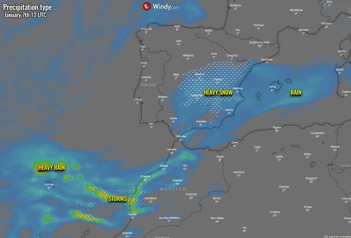
There is now an increasing potential of snow, locally also heavy snow, over the eastern parts of Spain, associated with the upper wave and the surface low in the southwestern Mediterranean. The featured low further southwest is generating a lot of stormy activity from Madeira to the Canary Islands, as well as into western Morocco. This activity is gradually turning towards southwestern Europe, including Spain and Gibraltar. Image is provided by Windy.com
DEEP LOW DEVELOPS STORMS INTO GIBRALTAR ON FRIDAY
The surface low will be strengthening and push its central pressure close to 995 mbar while nearing southern Spain, Gibraltar, and northwestern Morocco on Friday. As the general pattern supports blocking high further north, the low has no other way except to travel across southern Iberia into the southwestern Mediterranean tomorrow night. We can also see the eastern low moving into the Balkans, winter storm is underway through the day into Friday night as it travels east. Image is provided by Windy.com
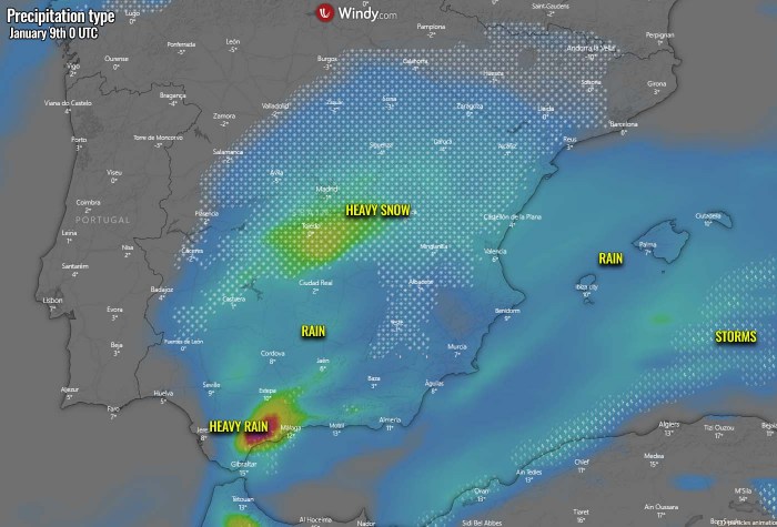
The arrival of the low into southern Iberia will increase precipitation along its path, being as heavy snow across eastern Spain but heavy rain and also pretty stormy across the far southern Spain, Gibraltar, and western Morocco. The classic low-level moist easterly flow south of the Spanish Sierra Nevada mountains will result in very heavy, excessive orographic rainfall around Gibraltar as well. Combined with storms, the area could receive a lot of rain from Friday daytime into the night hours and early Saturday. Flooding could become an issue locally. Image is provided by Windy.com
WINTER STORM FOR SPAIN ON FRIDAY NIGHT INTO SATURDAY
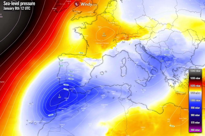
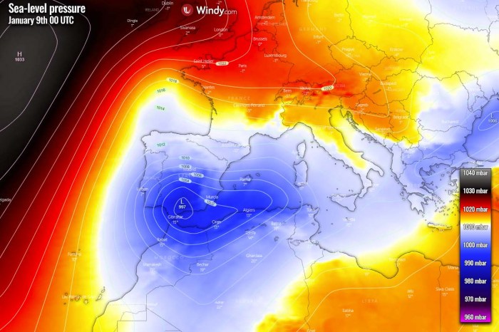
Through Friday night, the surface low will remain deep, with central pressure around 997 mbar while traveling across southern Spain. It will grow quite large and spread across most of the Iberian peninsula, the western Mediterranean, and also into Tunisia, northern Algeria, and most of Morocco. The strong North Atlantic ridge remains to the west, blocking any potential westerly flow towards western Europe. So the meridional flow on its eastern side maintains cold advection into central and southwestern Europe over the weekend. Image is provided by Windy.com
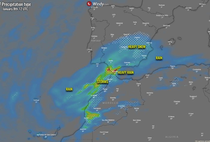
With the low remaining deep and drifting across southern Spain into the western Mediterranean, precipitation is expected to increase overnight to Saturday. This means that a significant winter storm with heavy snow will develop across east-central Spain, with very high snowfall rates at times. As it will be mostly dry snow, it will accumulate quite fast.
Heavy rain will be ongoing further south, due to warm advection pushing in ahead of the low. While far southern Spain (Andalusia region) should experience very heavy rain with high flooding potential. Storms are expected there as well, even severe storms given the marginal instability coupled with very strong shear. Although the majority of the rain will be from the orographic precipitation into higher terrain. Image is provided by Windy.com
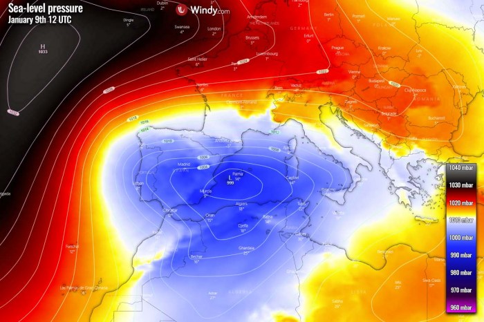
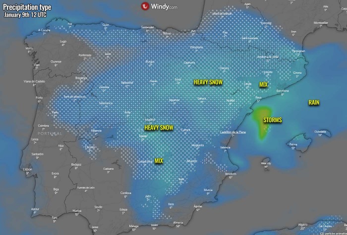
Going into Saturday, the surface low will be over the western Mediterranean and remain rather deep, with the central pressure slightly below 1000 mbar. The easterly moist advection will remain further west into eastern half Spain through all day, also towards the northeast parts and the Pyrenees. Notice the high-pressure system over the Atlantic, now extending also into western Europe. This will, together with the Mediterranean low, help the meridional flow to curve southwestward and support cold weather across most of Iberia and towards the Azores, Madeira, and the Canary Islands. Image is provided by Windy.com
Heavy snow will be underway across a large part of Spain, including the northern and western parts. Snowfall will also be possible over northern Portugal’s higher terrain. As well as across the Pyrenees into the Saturday night hours. The coastal areas of eastern Spain will see heavy rain, potentially also some mixing with snow a bit further inland. Storms could continue off the coast over the sea. Nevertheless, an amount of rain/snow will be quite significant until the nighttime. Image is provided by Windy.com
LOCALLY MORE THAN 50 CM OF SNOW IN THREE DAYS
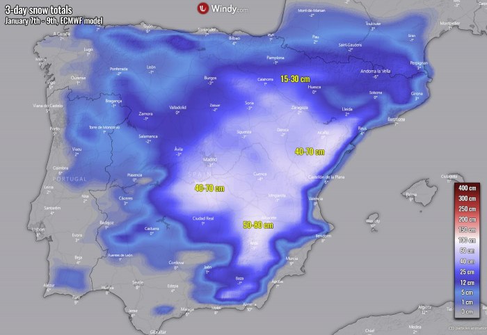
As the event will actually be a combination of today’s (Thursday), Friday night, and Saturday night winter storm, the amount of snow will be very high locally. Thanks to the overall cold pattern over southwestern Europe this weekend and the coming weekend. So, as most of the weather models are hinting at, high snow depth could result until Sunday morning. The attached ECMWF model chart below hints at an impressively large area of eastern and central Spain to receive even more than half a meter (50 cm) of snow. Image is provided by Windy.com
The amount of snow strongly depends on the local topography, as precipitation will also be increased by the orographic effects with the eastern moisture advection inland to Spain. There, snow totals could even reach 75-100 cm of fresh snow over the next three days (Thursday through Saturday). Here is an example by the ICON-EU model which is simulation many areas could get 40-80 cm of snow throughout this winter storm event. Image is provided by Windy.com
The higher the elevation, the more snow will accumulate as it is also colder and snow will be drier. One particular mountainous area on the chart above is having 100+ cm of snow forecasted. The model is hinting the easterly advection will dump a huge amount of snow there, thanks to the flat terrain to their east. This could mean that the precipitation is being strongly enhanced when more orographic lifting occurs into those mountains. This is how high rainfall/snowfall sums normally happen.
SIGNIFICANT FLOODING THREAT FOR GIBRALTAR
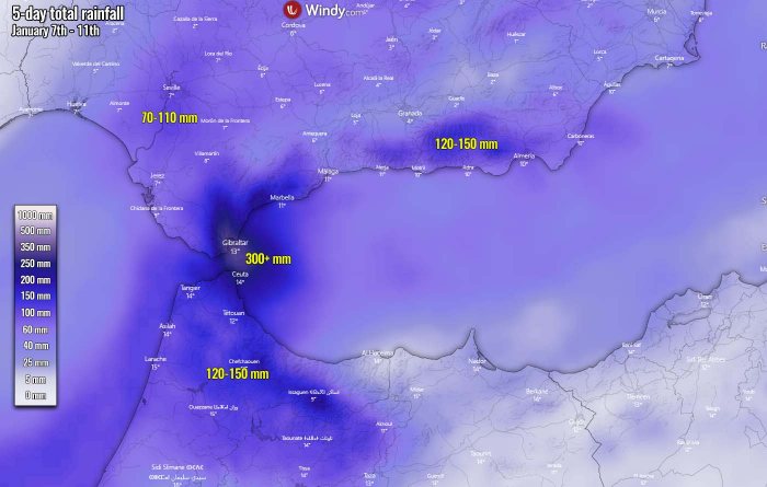
It has to be also noted, that there is a significantly increased threat for flooding in southern Spain, as well as northern Morocco and especially near the Gibraltar strait. A strong moisture advection with the easterly flow will maintain for days, so it will accumulate a lot of rain where their orographic effects will be maximized. 70 mm to nearly 150 mm will be possible across parts of the Andalusia region, even more in the far southern parts and indeed Gibraltar. There, the potential exists for more than 300 mm of total rainfall accumulation until Monday! Image is provided by Windy.com
Aftermath of the storm "Filomena" in Madrid (Spain), January 2021. Madrid in the snow:
PS After this video, where people ride dog sleds around the Spanish capital, I remembered a session where C 's was suddenly asked: "Laura, do you like skiing? Perhaps you will need them soon" (something like that).
I know that Laura loves dogs and she has several of them. So, dear Laura, maybe we should pick up a couple more dogs for the sledding? I recommend taking Siberian huskies.

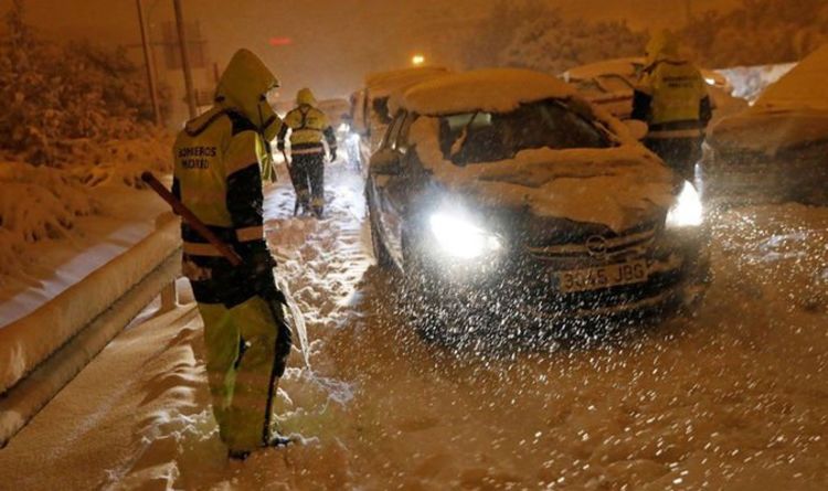
Spain weather: Storm Filomena brings never-before-seen SNOW to Madrid
STORM FILOMENA has sparked never-before-seen scenes of snow across Spain's capital city of Madrid, leaving half of the country in red alert and even recording temperatures as low as -36C - the coldest on record.
STORM FILOMENA has sparked never-before-seen scenes of snow across Spain's capital city of Madrid, leaving half of the country in red alert and even recording temperatures as low as -36C - the coldest on record.
Earlier this week, a record-breaking temperature of -35.8C was registered on Thursday in the northwestern province of Leon - the coldest temperature the country has ever recorded.
BBC Breakfast host Charlie Stayt said: "You are unlikely to have ever seen a picture of Madrid like this. It is the first snowfall in 10 years.
BBC Weather meteorologist Helen Willets added: "This is a one in 30-year event.
Swiss: The thermometer recorded a temperature of around -30 degrees (-22 F) in the night of Saturday to Sunday in Toggenburg (SG). So far this is the coldest night of this winter.

 www.20min.ch

La Suisse orientale a frôlé les -30 degrés
Le thermomètre a enregistré une température avoisinant les -30 degrés dans la nuit de samedi à dimanche dans le Toggenbourg (SG). Il s’agit jusqu’alors de la nuit la plus froide de cet hiver.
Aftermath of the storm "Filomena" in Madrid (Spain), January 2021. Madrid in the snow:
So a few days ago Spain recorded its lowest temperature ever at -34C. Today Madrid sees its heaviest snowfall in 50 years.
From France 24:
Madrid sees heaviest snowfall in 50 years as storms snarl travel in Spain
Four people died in Spain as Storm Filomena caused travel chaos across the country, blanketing Madrid in the heaviest snowfall in decades and forcing authorities to mobilise troops to rescue trapped motorists.
Rescue services reached 1,500 people trapped in cars, while skiers glided down Gran Via, normally one of the busiest streets in the capital. Other Madrid residents used the freak blizzard to snowboard down the road or pelt each other with snowballs.
A man and woman who were traveling in a car drowned after a river burst its banks near Malaga, southern Spain, and two homeless people froze to death, one in Madrid and the other in the eastern city of Calatayud, authorities said.
Responding to the events, King Felipe VI and Queen Letizia tweeted: "The royal family would like to express their sorrow for victims of the storm ... and ask for extreme caution against the risks of accumulation of ice and snow."
Interior minister Fernando Grande-Marlaska urged Spaniards to avoid all but essential travel. "We are facing the most intense storm in the last 50 years," he said.
More than 650 roads were blocked by snow, said Grande-Marlaska, leaving some drivers stuck in their cars from Friday night until Saturday.
Patricia Manzanares, trapped in her car on the M-40 motorway in Madrid since 7 p.m. on Friday, told RTVE television: "I have been stuck here without water or any other help".
Aena, which controls the country's airports, said Madrid's Barajas airport, which was closed on Friday night, would remain shut for the rest of Saturday. It said at least 50 flights to Madrid, Malaga, Tenerife and Ceuta, a Spanish territory in North Africa, were canceled.
The State Meteorological Agency said it was the heaviest snowfall in Madrid since 1971, while José Miguel Viñas, a meteorologist from Spanish National Radio, said that between 25 cm and 50 cm (10-20 inches) had fallen in the capital, which he said made it the largest snowfall since 1963.
Atletico Madrid's game against Athletic Bilbao, scheduled to kick off at 1515 GMT on Saturday, was postponed, La Liga said in a statement.
(REUTERS)
Soon we may need to amend this thread title to.....The Ice Age is Here!
I was having the same thought... To see the beginning of the Ice Age. What is more amazing is when I say to my friends "we are entering now the Ice Age" they continue as nothing, it is like my words fall on the floor like flakes and disappear. They even say: oh, it is normal, we are in winter station.You know, if we really are watching the onset of an ice age, it's kind of bizarre seeing it all happen in slow motion, so to say, while hardly anyone is paying attention.
Well.
Minus 37 ( -37) in some part of Spain is really a very important sign, at least for me...
There is also reports that China is confronting one of the stronger winters since 20 years ago, lots of snow as well.

 www.chinadaily.com.cn
Beijing is experiencing a strong cold wave that started early Wednesday, with the lowest temperature forecast to reach minus 19 degrees Celsius.
The lowest temperature recorded in the city since 2000 was minus 17 degrees Celsius, according to the Beijing meteorological station.
The first cold wave in 2021 features a "dramatic temperature drop," "significant wind-chill effect" and "prolonged period of low temperature," said Lei Lei, chief forecaster of the station.

Strong cold wave sweeps across China
Beijing is experiencing a strong cold wave that started early Wednesday, with the lowest temperature forecast to reach minus 19 degrees Celsius.
 www.chinadaily.com.cn
Well, people can "welcome" the coming ice age "The Battle of Snow White"You know, if we really are watching the onset of an ice age, it's kind of bizarre seeing it all happen in slow motion, so to say, while hardly anyone is paying attention.
or dance the macarena...
I was having the same thought... To see the beginning of the Ice Age. What is more amazing is when I say to my friends "we are entering now the Ice Age" they continue as nothing, it is like my words fall on the floor like flakes and disappear. They even say: oh, it is normal, we are in winter station.
Well.
Minus 37 ( -37) in some part of Spain is really a very important sign, at least for me...
It looks increasingly uninteresting.
Trending content
-
-
Thread 'Coronavirus Pandemic: Apocalypse Now! Or exaggerated scare story?'
- wanderingthomas
Replies: 30K -
-

