The Edge of Space Just Crept 12 Miles Closer to Earth
By Brandon Specktor, Live Science Senior Writer | July 26, 2018 11:00am ET

Did you feel that? Does it suddenly feel a little bit
stuffier in here to you? Does it feel like, I don't know… outer space just got 12 miles (20 kilometers) closer?
Nothing actually moved, of course (unless you count the constant and increasing
expansion of the universe). But according to a
new study published online this week, it might be high time Earthlings shifted our mental and mathematical ideas about where, exactly,
Earth's atmosphere ends and outer space begins. [
Earth from Above: 101 Stunning Images from Orbit]
If astrophysicist Jonathan McDowell's calculations are correct, the cosmic boundary where the laws of airspace suddenly give way to the laws of orbital space might be a lot closer than we think — a full 12 miles closer than previous estimates suggest.
"The argument about where the atmosphere ends and space begins predates the launch of the first Sputnik," McDowell, an astrophysicist at the Harvard-Smithsonian Center for Astrophysics, wrotein his new paper, which will appear in the October issue of the
journal Acta Astronautica. "The most widely accepted boundary is the so-called
Karman Line, nowadays usually set to be 100 km (62 miles) altitude."
Here's the problem: According to McDowell, that Karman line that many scientists accept today is based on decades of misinterpreted information that doesn't actually take real orbital data into account. Luckily, data is McDowell's business (and his pleasure — in his free time he keeps meticulous records of
every rocket launch on Earth) and he knew just where to look to find an evidence-based answer to the question, "Where does space begin?"
 Where satellites fall
In his new study, McDowell pored over data describing the orbital paths of some 43,000 satellites, which he collected from the North American Aerospace Defense Command (NORAD), which monitors aerospace in the United States and Canada. Most of these satellites were negligible to McDowell's study — they orbited far higher than the proposed Karman line, and were well within the grasp of orbital space.
About 50 of these satellites, however, stood out. While re-entering the atmosphere at the end of their missions, each of these satellites successfully completed at least two full rotations around the Earth at altitudes below 62 miles (100 km). The Soviet Elektron-4 satellite, for example, circled the planet 10 times at around 52 miles (85 km) before tumbling into the atmosphere and burning up in 1997.
It seemed clear from these cases that the physics of space still held sway well below the Karman line. When McDowell used a mathematical model to find the exact point at which various satellites finally broke loose of their orbits and made a fiery return to the atmosphere, he found that this could occur anywhere between 41 to 55 miles (66 and 88 km). Usually though, when a craft dipped below the 50-mile (80 km) mark, there was no hope of escape.
Astronaut wings
For this reason, McDowell chose 50 miles as the true lower edge of space. The number fit neatly with several other cultural and atmospheric factors, as well. For example, McDowell wrote, in the 1950s, US Air Force pilots were awarded a special set of "astronaut wings" for
flying their planes above 50 miles, this being considered the outermost edge of the atmosphere.
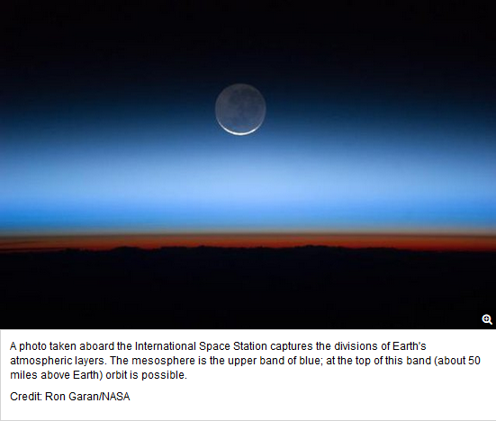
Atmospherically, the choice fits, too: The
mesopause — the coldest belt of Earth's atmosphere — stretches roughly between 52 and 62 miles above the planet's surface. Here, the atmosphere's chemical composition begins to change drastically and charged particles become more abundant. (In other words, things look a lot spacier.) It's clear that, below the lower edge of the mesopause, Earth's atmophere becomes a stronger force for airborn objects to reckon with, McDowell wrote. [
Infographic: Earth's Atmosphere from Top to Bottom]
"It is noteworthy that
meteors (traveling much more quickly) usually disintegrate in the 70 -100 km (43 miles to 62 miles) altitude range, adding to the evidence that this is the region where the atmosphere becomes important," McDowell wrote.
So, what does it mean if the boundary between Earth and space is 20 percent lower than is generally accepted? It won't change the way rockets are launched or any other physical interactions with space, McDowell wrote, but it could raise some important political and territorial issues.
The airspace above a given country is generally considered part of that country; outer space, on the other hand, is for everyone. If space is defined as beginning at 62 miles and the U.S. flies an unauthorized satellite at 52 miles over China, for example, that could be (justifiably) construed as an
act of military aggression.
For this reason, the U.S. has frequently opposed setting any universal space boundaries. That means that McDowell's proposed 50-mile line probably won't become a legal, universally accepted border anytime soon. Still, if the daily drudge of life on Earth starts to get you down, look up — and take heart that you may be a little bit closer to the heavens than you were last week.
Originally published on Live Science.


 More like Social discord, aka
 super. Tomate31
