In Southern Scandinavia, Denmark, it has been the most sunny summer on record and one of the very warmest with an average of about 17,5 degrees Celsius over the period from June to September. We are catching up on precipitation, but it is still expected to be 25 % below normal. Right now the temperature is between 12 and 19 degrees Celsius. If global warming often precedes an ice age, then all is on track. In Greenland the melting has reached its summer minimum, and the mass of the ice sheet appears now to be either stagnating or on the increase. What one notices on the figure on Indlandsisens massebalance: DMI showing the percentage of the area of Greenland, where ice melts this year has seen substantial deviations from the average with periods of unusually warm or unusually cold weather.
You are using an out of date browser. It may not display this or other websites correctly.
You should upgrade or use an alternative browser.
You should upgrade or use an alternative browser.
The Ice Age Cometh! Forget Global Warming!
- Thread starter Gaby
- Start date
August snow forecast for Montana and Wyoming tonight in the US.
"I was quite impressed with the GFS, ECMWF, and even the CMC computer model runs. My#snow forecast calls for about 1 inch up to 3 inches of #snow for parts of Western MT and Northwestern WY. Some isolated spots may see 3 to 6 or even 6 to 9 inches tonight through tomorrow morning"
edit added: Maybe it isn't that out of the ordinary for the mountains...
August snow for Montana, Wyoming and Idaho - Ice Age Now
"I was quite impressed with the GFS, ECMWF, and even the CMC computer model runs. My
edit added: Maybe it isn't that out of the ordinary for the mountains...
August snow for Montana, Wyoming and Idaho - Ice Age Now
But don’t worry. That’s normal. “Snow is not uncommon in the higher elevations of the northern Rockies in late August,” says weather.com.
Of course, they’re the same people who keep on harping about “global warming.”
Which is it?
In Southern Bavaria we missed the spring weather this year. Shortly after Easter we switched from cold winter weather to warm / hot and relatively dry summer weather. I do not remember that we ever had something similar in my life. In 2003 it was also a hot summer but with more rain in spring. It seems to me that this year we had the hot summer, which is typical for the Mediterranean region and Southern Europe had summer weather typical for my region. I remember that I was surprised that there was warmer weather here in Southern Bavaria then in Southern France when I traveled there in May.
Germany has a year of much less crops or even failed crops in 2018 as there was much too less rain in many regions. But it will see a great wine year. In our garden there was a good harvest for all types of fruit due to appropriate good weather during bloom, ripening and harvest with just enough rain.
Together with the hot summer weather mass media started to talk a lot about climate change as they call global warming now. They did not mention climate change during the last cold winter ...
angelburst29
The Living Force
This is turning out to be "The Year Almost Without a Summer".
27 August 2018 - Ski season starts in... August: European heat wave comes to an abrupt end as snow falls in Germany and Austria (Photos)
Ski season starts in August: European heatwave comes to an end as snow falls in Germany and Austria | Daily Mail Online
Up to 40cm of snow was dumped in parts of Europe - despite it being summer
- The German Weather Service said the temperature plummeted 86F (30C)
- 'Anyone without a sweater or jacket was probably shivering quickly,' it said
About 25cm of snow was dumped on Germany's highest peak, the Zugspitze, where temperatures reached a decidedly chilly 19.4F (-7C) yesterday.
The German Weather Service posted on Facebook this morning that the temperature had plummeted 86F (30C)'.
In a press release, it said that those who ventured outside early yesterday would have experienced a 'pretty cold surprise. With only single-digit temperatures, the heat of the previous day was quickly forgotten.'
It explained that while temperatures last Thursday climbed to 91.4F (33C) in Offenbach, with many people cooling off in lakes or swimming pools, 'the temperature was only 44.6F (7C) around 6.30am on Sunday.
'Anyone without a sweater or jacket was probably shivering pretty quickly.'
Innsbruck Tourism took to social media today to herald the 'first snow on the mountains around Innsbruck last night'.
And according to Mountainwatch, heavy snow fell above 1,500 metres across the European Alps over the weekend, 'with a number of destinations reporting over 40cm of the fluffy white stuff'.
Skiing was possible across half a dozen glacier dependent ski fields across Switzerland, Austria and Italy, it added.
The German Weather Service said it was 'hard to believe' there was such 'freezing air at the end of August'.
'The midsummer weather was replaced within two-and-a-half-days by an autumnal-looking weather character. Snow even fell in the Bavarian Alps.
'While in the Allgäu Alps, the snow line was at about 2,000m, it snowed on the eastern edge of the Alps even down to about 1,300m,' it added.
There were also reports of snowfall from communities below 900m in altitude.
The weather service said the snowfall at such low levels provided good conditions for skiing and tobogganing – 'sometimes hardly the case in winter'.
It pegged the 'massive drop in temperature [to] a fundamentally changing weather situation'.
The front of a low over the British Isles, and very warm to hot air masses from southern or southwestern climes from the Mediterranean or North Africa were 'pumped to us' last Thursday, the service explained.
'On Friday, the two cold fronts of the lows passed over us, with the current turning to the northwest.
'This cleared the way for colder air of polar origin, which was somewhat warmed up over the still warm North Sea (water temperatures at the coast at 19 to 20 degrees Celsius), but still let the temperatures continued to sink until Sunday.'
However, warmer weather is returning to Germany, with the service saying that people can expect temperatures to reach 86F (30C) over the next few days, 'although it cools down again in the nights and in some places there are single-digit low temperatures'.
A proliferation of extreme weather events around the world provides ample evidence that climate change is a reality, German Chancellor Angela Merkel said on Sunday, but she rejected calls for more ambitious climate protection goals.
Extreme temperatures across the northern hemisphere this summer have fuelled concerns that climate change is gathering pace, leading dozens of countries to call for greenhouse gas emissions to be cut at a faster rate than planned. (Article continues.)
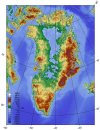
With regard to the ice sheet balance for Greenland, it's time to pull down the data, as the year showing accumulation runs from September 1 to September 1. The attached files are from Indlandsisens massebalance: DMI with the fourth being from Wikipedia. On DMI they write that the glaciers in Greenland are not in balance and that ice in Greenland on average looses 200 km3 or 200 Gt per year. The final verdict for this year may not be in yet, but lets take a look at what their maps.
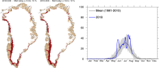
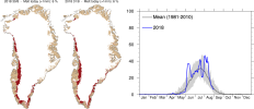
The first shows where there is accumulation due to snowfall (blue) and losses due to melting (red). It appears that the west coast i loosing and the south east is gaining.
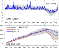
The second file has two diagrams. The top shows the uneven spikes of the precipitation over the past year. The grey area is where most values from previous years have been located, except the very highest and the very lowest for each day. Notice the high spikes going out of the grey "normal" area in mid September of last year, in late October of last year, in late February of this year and most recently in late August of this year. In order for so much snow to drop, the air must previously have contained a lot of moisture. Since warm air can hold much more moisture than cold air, as warm humid air cools down, the moisture is condensed and released. Over the east coast of Greenland one can imagine humid air moving in from the Atlantic. As this air is pressed up by the land and ice mass, it cools down and drops snow.
In the second diagramme of the second image file, one notices that the gain this year has been around 100-150 Gt above average. But again, there is an imbalance in the amount of melting going on the east as compared to the west coast, where also some of the most active glaciers are located. The movement of a glacier is facilitated by melting ice which releases water and thus helps to break down the structure of the glacier and ease the flow.
The third figure has two maps to the left, and a chart to the right showing the percentage of melt. At the moment the percentage is around normal, and in a few weeks it will be down to zero, as winter approaches.
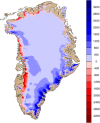
The fourth file shows Greenland without ice. The tall mountains in the South East correspond to the area where much snow has fallen since last year. Notice that the glaciers appear to have an easier exit to the sea on the west coast where mountains tend to be lower.
The first shows where there is accumulation due to snowfall (blue) and losses due to melting (red). It appears that the west coast i loosing and the south east is gaining.
The second file has two diagrams. The top shows the uneven spikes of the precipitation over the past year. The grey area is where most values from previous years have been located, except the very highest and the very lowest for each day. Notice the high spikes going out of the grey "normal" area in mid September of last year, in late October of last year, in late February of this year and most recently in late August of this year. In order for so much snow to drop, the air must previously have contained a lot of moisture. Since warm air can hold much more moisture than cold air, as warm humid air cools down, the moisture is condensed and released. Over the east coast of Greenland one can imagine humid air moving in from the Atlantic. As this air is pressed up by the land and ice mass, it cools down and drops snow.
In the second diagramme of the second image file, one notices that the gain this year has been around 100-150 Gt above average. But again, there is an imbalance in the amount of melting going on the east as compared to the west coast, where also some of the most active glaciers are located. The movement of a glacier is facilitated by melting ice which releases water and thus helps to break down the structure of the glacier and ease the flow.
The third figure has two maps to the left, and a chart to the right showing the percentage of melt. At the moment the percentage is around normal, and in a few weeks it will be down to zero, as winter approaches.
The fourth file shows Greenland without ice. The tall mountains in the South East correspond to the area where much snow has fallen since last year. Notice that the glaciers appear to have an easier exit to the sea on the west coast where mountains tend to be lower.
Attachments
This is turning out to be "The Year Almost Without a Summer".
Here it is going to be one of the hottest summer for the last decades.
angelburst29
The Living Force
The Antarctic iceberg A-68 has begun to spin. After a year-long standstill, the massive chunk of ice is on the move.
Sep 5, 2018 - Antarctic iceberg A-68 is on the move after year-long standstill
Antarctic iceberg A-68 is on the move after year-long standstill
A-68 split from the Larsen C ice shelf last July. Scientists predicted the giant iceberg would begin to fragment shortly after its separation.
But over the last year, A-68 has remained mostly intact, anchored to the Bawden Ice Rise, a shallow seabed near the edge of the Larsen ice shelf. Scientists used satellite images to monitor the iceberg, but until now, there was little movement to report.
Now, just more than year after it first separated, A-68 is beginning to drift again.
A-68 has started to swing northwards," scientists Mark Brandon reported in a blog update.
The right combination of weather conditions and ocean currents caused the iceberg to being to rotate counterclockwise.
The iceberg has lost a couple of sizable chunks, but it remains nearly as massive as it was 13 months ago.
Its size is roughly four times the size of the city of London, and its volume is twice that of Lake Erie. A-68 weighs more than 1 trillion metric tons.
As of last July, A-68 was the sixth largest ice berg of all time, with an area of 2,239 square miles, according to Brigham Young University's Antarctic Iceberg Tracking Database.
The bottom of the iceberg is likely to leave large gashes in the seafloor's icy sediment -- gouges likely to be revealed by sonar surveys of the region scheduled for later this year.
Now that the iceberg is on the move, it's becoming more exposed to ocean currents and warmer waters. As a result, A-68 is likely to keep spinning and drifting away from the ice shelf from which it was calved.
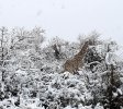
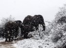
There is still winter in South Africa and it is known that it snowed also in the past there, nonetheless somehow in recent years it snowed much more than in the years before, according to this records:
History of Snow in Southern Africa: 1853 – 2017 | Snow Report SA
Anyway this is a new report with some attached pictures:
History of Snow in Southern Africa: 1853 – 2017 | Snow Report SA
Anyway this is a new report with some attached pictures:
Attachments
In my experience living in northwestern Alberta, the first snowfall is usually seen around Halloween, end of Oct - early November, so a forecast of 5-10 cms in mid-September is quite early. It will be interesting to see if it all melts away or sticks around into the wintertime.
Summer snowstorm expected to hit western Alberta, Canada -- Sott.net
Summer snowstorm expected to hit western Alberta, Canada -- Sott.net
It may still be summer, but communities in western Alberta are being told to hunker down for a blast of wintry weather.
A snowstorm is expected to whip into the province later this week. On Monday, Environment Canada issued a special weather statement for areas including Jasper, Grande Prairie, Nordegg and Rocky Mountain House.
A cold north wind is to blame for the incoming blizzard.
"A cool air mass will invade much of Alberta this week, bringing with it weather that is decidedly more like winter than summer," the advisory reads.
"A cold front is forecast to drop southward out of the Northwest Territories on Tuesday and Wednesday, and it will bring precipitation with it."
In the higher terrain, particularly between Grande Prairie and Jasper, the snow is expected to hit on Wednesday.
Somewhere between five and 10 centimetres of heavy, wet snow is expected to fall across the region but some areas under the advisory may receive more.
Areas to the south and east, including Edmonton, will likely also see a few snowflakes fall on Wednesday, but the weather agency expects that it will melt quickly.
Edmonton's temperature is expected to drop of a low of zero Wednesday amid rain showers or flurries, while periods of snow or rain are forecast for Thursday.
The storm will move south through the afternoon and evening on Wednesday and may reach as far south as Banff by Thursday morning.
angelburst29
The Living Force
In my experience living in northwestern Alberta, the first snowfall is usually seen around Halloween, end of Oct - early November, so a forecast of 5-10 cms in mid-September is quite early. It will be interesting to see if it all melts away or sticks around into the wintertime.
Summer snowstorm expected to hit western Alberta, Canada -- Sott.net
Sep 21, 2018 - It's the first snowfall, Saskatoon! Flurries predicted for weekend forecast
It's the first snowfall, Saskatoon! Flurries predicted for weekend forecast | CBC News
Pumpkin festival cancelled due to bad weather

Predicted snowfall could turn a pumpkin patch into a winter wonderland. (Submitted by Amanda Devoe Muirhead)
Tomorrow might be the first official day of fall, but parts of Saskatchewan may end up looking like a winter wonderland thanks to this weekend's weather forecast.
A system is moving in from Alberta is bringing a mix of rain and snow to much of central Saskatchewan.
Temperatures are expected to dip toward the freezing mark throughout the day Friday in Saskatoon. And that could mean a mix of rain and snow through the afternoon in the city.
Much of central Saskatchewan could see light flurries on and off through the weekend with accumulated snowfall between 2-4 cm.
Pumpkin festival a snow-go
Winter-like weather isn't always so wonderful—especially when you run an outdoor event like Black Fox Farm and Distillery's annual pumpkin festival. It's forced event organizers to cancel this weekend's festivities.
"It is just not that much fun when it is snowing," said Barb Stefanyshyn-Cote, one of Black Fox's owners.
The pumpkin festival, which typically runs during the first three weekends in September, has already been postponed once this year due to bad weather.
The festival features a number of family-friendly activities including children's games, wagon rides and, of course, pumpkin picking.
"We have 15 thousand pumpkins that are waiting in the field for people to come and get them," said Stefanyshyn-Cote. "We don't know what's going to happen to them [the pumpkins] should the weather dip even lower."
Patchy predictions
Luckily for the pumpkins—and potential pumpkin pickers—the snow isn't expected to stick around for very long.
Temperatures should start to warm up a little Sunday evening and double digit highs are are expected next week.
The Black Fox pumpkin festival still runs for two more weekends: Sept. 29- 30 and Oct. 6-7.
Plenty of time of to pick the perfect pumpkin — and plenty of pumpkins to pick from.
Sep 17, 2018 - 'Like somebody flipped a switch': parts of Sask. see September snowfall (Photos)
'Like somebody flipped a switch': parts of Sask. see September snowfall | CBC News

Photo taken at Belbutte, Sask., near Spiritwood. (Submitted by Evelyn Johnson)
Some areas of Saskatchewan woke up to a winter wonderland on Monday. Several centimetres of snow fell in west-central areas of the province, while places north of Prince Albert saw some as well.
The area hit most was around Spiritwood, including Belbutte and Meeting Lake.
Farmers’ Almanac's Winter 2019
https://www.farmersalmanac.com/weather-outlook/2019-winter-forecast
The 2019 Farmers’ Almanac, which provides 16 months’ of weather forecasts for 7 zones in one compact book, is predicting that winter 2019 will be “Colder-than-normal… from the Continental Divide east through the Appalachians.”
Cold Winter Ahead!
So just how cold will it be? The real teeth-chattering arrives mid-February especially in the following zones: Northeast/New England, Great Lakes, Ohio Valley, Midwest, and Southeast (yes, even the Southeast will be in the chill zone!).
During this time, an Arctic cold front will produce blustery and bitter winds, a sharp drop in temperature, and widespread snow showers/squall activity along and ahead of the frontal line. (Find out all the details of when this arctic blast is predicted to spill into these regions in the 2019 Farmers’ Almanac.)
Snow Way Out?
The Farmers’ Almanac, which bases its amazingly-accurate long-range forecast on a mathematical and astronomical formula developed in 1818, is also predicting above-normal precipitation (lots of snow!) for the Great Lakes states, Midwest, and central and northern New England, with the majority of it falling in January and February.
Farmers’ Almanac Winter Outlook At A Glance:
- Colder-than-normal conditions are predicted from the Continental Divide east through the Appalachians.
- Above-normal snowfall predicted for Great Lakes, Midwest, New England, Pacific Northwest
- Frigid weather is expected in mid-February, which may also bring blustery and bitter winds, widespread snow showers, especially in zones 1, 2, and 3.
- Winter will hang on with stormy conditions up through the official start of spring, especially for the East Coast.
Above-normal precipitation is also forecast for the Southwest region during December 2018, and for the Southeast in January and February 2019. The rest of the nation will see closer to normal snowfall amounts, although, as the 2019 Farmers’ Almanac suggests, a stormier-than-normal March could push snowfall totals to above normal over the northern and central Rockies and Plains. Good news for skiers and boarders!
Significant snowfalls are also predicted for parts of all 7 of our zones (check out what we’re predicting for your zone here.).
A Late Start to Spring?
Mid-March could be stormy virtually coast to coast, bringing snow, sleet, and/or rain as well as strong and gusty winds to many areas. In particular, we are red-flagging March 20–23 for a potent East Coast storm that could deliver a wide variety of wintry precipitation just as we are making the transition from winter to spring. So, no matter what the groundhog says in February, you’ll know winter isn’t going anywhere anytime soon.
mrtn
Dagobah Resident
spaceweather.com
THE CHILL OF SOLAR MINIMUM: The sun is entering a deep Solar Minimum, and Earth's upper atmosphere is responding. Data from NASA's TIMED satellite show that the thermosphere (the uppermost layer of air around our planet) is cooling and shrinking, literally decreasing the radius of the atmosphere. If current trends continue, the thermosphere could set a Space Age record for cold in the months ahead. Visit today's edition of Spaceweather.com for the full story.
Indonesian Tsunami & Record Snow More Grand Solar Minimum Signs (718)
<iframe width="560" height="315" src="
" frameborder="0" allow="autoplay; encrypted-media" allowfullscreen></iframe>
With the Indonesian 7.7 earthquake and tsunami, at the same time Krakatou awoke with over 50 eruptions in the W. Java island area. All time coldest days in Germany and Netherlands, snowiest September in Alberta and massive frost damage to Australian crops in spring. Do you think the intensifying Grand Solar Minimum is the cause of the changes we are seeing?
<iframe width="560" height="315" src="
spaceweather.comTHE CHILL OF SOLAR MINIMUM:The sun is entering a deep Solar Minimum, and Earth's upper atmosphere is responding. Data from NASA's TIMED satellite show that the thermosphere (the uppermost layer of air around our planet) is cooling and shrinking, literally decreasing the radius of the atmosphere. If current trends continue, the thermosphere could set a Space Age record for cold in the months ahead. Visit today's edition of Spaceweather.com for the full story.
I've been saying this over and over again for awhile: that the atmosphere is "falling", so to say. That's one of the biggest reasons for the increase in contrails that make people go nuts and scream about "chemtrails". I have said over and over again that this evidence for the lowering of the coldest layer of atmosphere is a harbinger of things that are way worse than any chemical spraying could ever be, and certainly not under the control of human beings. And now, all of a sudden, it's becoming "official". But it's been in process for quite a number of years now!!!
Meanwhile, I'm sure the global warming nutjobs will spin this as global freezing due to global warming. And meanwhile, they keep on trying to think up ways to further cool the planet???
We sure do live in Bizarro World.
It is still warm here (Eastern NC), but contrails are really noticeable and lingering the last few days. For years I've been watching the sky for chemtrails after hearing so much about them, but never really seen too much of anything like that. Just sometimes some lingering contrails as compared to early 1970s. I've always liked watching our beautiful sky.
Trending content
-

-

-
Thread 'Coronavirus Pandemic: Apocalypse Now! Or exaggerated scare story?'
- wanderingthomas
Replies: 30K -