voyageur said:
angelburst29 said:
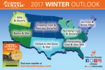
Farmers’ Almanac™ is once again proving that traditions never go out of style with the release of its 2017 anniversary edition on Monday, August 15, 2016. This expanded “throwback” edition features an eclectic mix of weather, astronomy, humor and everyday life-hacks, as well as the much-anticipated winter weather forecast.
Farmers’ Almanac Releases Special 200th Collector’s Edition And Forewarns of a Frigid Forecast
http://farmersalmanac.com/press-releases/2016/08/14/farmers-almanac-releases-special-200th-collectors
Thanks, angelburst29, was actually thinking about these Almanac folks and what they were predicting via their models. If what they say is so, it's like the 60's cold (as it was two years ago with the Great Lakes freezing over). The following is from your link for parts Canada. And here is a photo for the U.S.
Just updating: 2017 Long Range Weather Forecast for
Atlantic Canada
Annual Weather Summary: November 2016 to October 2017
Winter temperatures will be below normal, with the coldest periods in mid- and late December, mid- to late January, and mid-February. Snowfall and precipitation will be near or above normal, with the snowiest periods in mid- and late December, early to mid- and late January, and mid- and late February.
April and May will be a bit cooler than normal, with above-normal precipitation.
Summer will be warmer than normal, on average, with the hottest periods in mid-June and mid-August. Rainfall will be near or below normal, despite the threat of a tropical rainstorm in late August.
September and October will be slightly cooler than normal, with rainfall below normal north and above normal south.
In the last 7-8 weeks here, in Northeastern Pennsylvania, local weather reports keep repeating "we are in a Heat Dome" with unusual high humidity and temps during the day in the 88- 94 F. Nights have stayed in the lower 70's. Normally, in mid to late August, we may get a week and a half of this kind of humidity but not weeks upon weeks without a break. In between, it has rained - just about everyday, adding to the moisture. I wonder, if this Heat Dome and slow moving air mass is due to lower Solar activity? What happens if this Heat Dome reverses into a "Cold Dome" in the Winter? Sub-zero temps and non - stop snowing for weeks on end? We did get a slight break from the humidity, yesterday and today, it's back up again.
I may be mistaken but I think Canada has colder and snowier Winters than the U.S.? When local reports stress, "We're going to get an air mass from Canada" - we get a deep freeze with minus temps and everything freezes like a rock .... for days!
In the past, on and off, I had noticed "2-3 days before a Full Moon" if we were experiencing a heat wave, that weather conditions would get worse leading up to the full moon and last 2-3 days after it peaked. Last Fall and into the Winter, I decided to chart the weather conditions and temp's just before and after a full moon. It was more out of curiosity than any kind of experiment. (Amazing the things you can dream up when you have a little free time on your hands? I don't have a TV to amuse me.)
Sure enough, if the weather forecast called for "a cold snap" or heavy snow fall, conditions were worse a day or two before the moon was fully crested and lasted for another day or two afterwards. It was like a 5 day window. Last March was interesting. The forecasts called for sleet and rain, mixed in with periods of snow. During the night, temps went into the single digits. It was a day before full moon. It started out as rain mixed with sleet, then changed over to snow. Next morning, it started to sleet again. Interstates were closed - due to the number of accidents and stranded passengers. Secondary roads were closed (not plowed) Bus routes were shut down, schools and University's - closed including some of the stores in the Mall's. It took three days to plow a middle path on the roads leading in and out of Cities like Scranton, Wilkes Barre and East Stroudsburg. It wasn't the snow but the thick icy accumulation and single digit (F) temps that caused all the problems. When the temps began to recovered and reach 32F, the ice falling off tree branches - snapped power lines and whole communities were without electricity.
Here's the dates - if you want to try your own experiment? I have one of those calendars that you can write brief notes on. 7 AM every morning, I would log the temp and at night, make a note if it snowed, etc. and the reported inches and expected night time temp. I would circle the day of the full moon and compare notes. It was an interesting project. Think I'll do it again this Winter.
Full Moon Dates and Times
http://farmersalmanac.com/full-moon-dates-and-times/
Full Moon Calendar 2016
January 23rd Full Wolf Moon 8:46 pm
February 22nd Full Snow Moon 1:20 pm
March 23rd Full Worm Moon 8:01 am
April 22nd Full Pink Moon 1:24 am
May 21st Full Flower Moon 5:14 pm
June 20th Full Strawberry Moon 7:02 am
July 19th Full Buck Moon 6:57 pm
August 18th Full Sturgeon Moon 5:27 am
September 16th Full Harvest Moon 3:05 pm
October 16th Full Hunter's Moon 12:23 am
November 14th Full Beaver Moon 8:52 am
December 13th Full Cold Moon 7:06 pm
Full Moon Calendar 2017
January 12th Full Wolf Moon 6:34 am
February 10th Full Snow Moon 7:33 pm
March 12th Full Worm Moon 10:54 am
April 11th Full Pink Moon 2:08 am
May 10th Full Flower Moon 5:42 pm
June 9th Full Strawberry Moon 9:10 am
July 9th Full Buck Moon 12:07 am
August 7th Full Sturgeon Moon 2:11 pm
September 6th Full Corn Moon 3:03 am
October 5th Full Harvest Moon 2:40 pm
November 4th Full Beaver Moon 1:23 am
December 3rd Full Cold Moon 10:47 am