The Ice Age Cometh! Forget Global Warming!

Indonesia to move capital from sinking Jakarta to Borneo
August 27, 2019
Previous
1729706-310805478.jpg

1 / 3
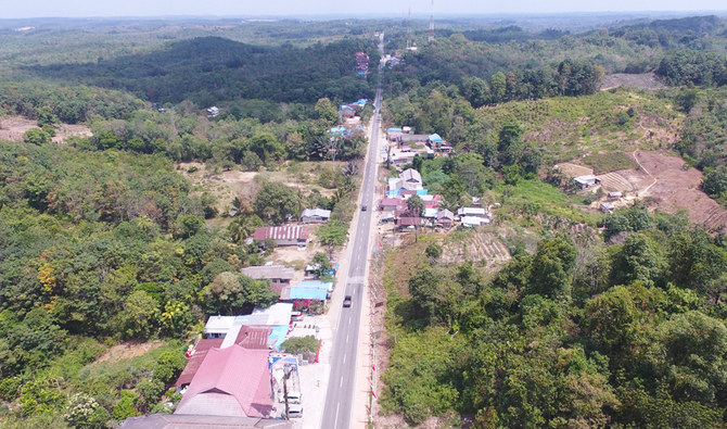
This aerial picture taken on August 16, 2019 by news outlet Tribun Kaltim shows a general view of Samboja, Kutai Kartanegara, one of two locations proposed by the government for Indonesia's new capital. (AFP)

JAKARTA, Indonesia: Indonesia’s president says the Country's Capital will move from overcrowded, sinking and polluted Jakarta to a site in sparsely populated East Kalimantan providence on Borneo Island, known for rainforests and orangutans.

President Joko Widodo said Monday intense studies over the past three years had resulted in the choice of the location on the eastern side of Borneo island.

The new capital city, which has not yet been named, will be in the middle of the vast archipelago nation and already has relatively complete infrastructure because it is near the cities of Balikpapan and Samarinda, Widodo said.

He said the burden has been become too heavy on Jakarta on Java island as the center of government, finance, business, trade and services as well as the location of the country’s largest airport and seaport.

Widodo said the decision was made not to move the capital elsewhere on Java because the country’s wealth and people are highly concentrated there and should be spread out.

Currently 54% of the country’s nearly 270 million people live on Java, the country’s most densely populated area. “We couldn’t continue to allow the burden on Jakarta and Java island to increase in terms of population density,” Widodo said at a news conference in the Presidential Palace. “Economic disparities between Java and elsewhere would also increase.”

In an interview with The Associated Press last month, Widodo said he wants to separate the center of government from the country’s business and economic center in Jakarta.

Jakarta is an archetypical Asian mega-city with 10 million people, or 30 million including those in its greater metropolitan area. It is prone to earthquake and flooding and is rapidly sinking due to uncontrolled extraction of ground water. The ground water and rivers are highly contaminated. Congestion is estimated to cost the economy $6.5 billion a year.

Mineral-rich East Kalimantan was once almost completely covered by rainforests, but illegal logging has removed many of its original growth. It is home to only 3.5 million people and is surrounded by Kutai National Park, known for orangutans and other primates and mammals.

Widodo said the relocation of the capital to a 180,000-hectare (444,780-acre) site will take up a decade and cost as much as 466 trillion rupiah ($32.5 billion), of which 19% will come from the state budget and the rest will be funded by cooperation between the government and business entities and by direct investment by state-run companies and the private sector.

He said the studies determined that the best site is between two districts, North Penajam Paser and Kutai Kertanegara, an area that has minimal risk of disasters such as floods, earthquakes, tsunamis, forest fires, volcanic eruptions or landslides in the seismically active nation.

Indonesia’s founding father and first president, Sukarno, once planned to relocate the capital to Palangkaraya in Central Kalimantan province.

Infrastructure improvement has been Widodo’s signature policy and helped him win a second term in April elections.

Decades of discussions about building a new capital on Borneo island moved forward in April when Widodo approved a general relocation plan. He appealed for support for the move in an annual national address on the eve of Indonesia’s independence day on Aug. 16.

He said Monday that his government is still drafting a law on the new capital which will need to be approved by Parliament.
 
Suspicious0bservers just came out with a new hour-long video called: Our future is cold.


CLIMATE FORCING | Our Future is Cold
14,437 views


Suspicious0bservers


Premiered 3 hours ago


Climate Change, Solar Forcing, Ice Age | From volcanic cooling born beneath our feet to the most seemingly distant reaches of both space time, we lay out Climate Forcing: the problems, path forward, and character of the finish line. This Will Be a Key Topic at OTF2020 in Denver: https://ObservatoryProject.com Subscribe for Daily Updates on the Sun, Earth and More This is the 3rd film we released this month, here are the other two: COSMIC DISASTER: https://youtu.be/B_zfMyzXqfI PLASMA COSMOLOGY: https://youtu.be/E4pWZGBpWP0 Special Thanks to Dr. Brian Tinsley, Professor Emeritus, University of Texas at Dallas

I haven't watched the above yet nor have i been keeping up to date with the creator's other work in the last year or so, but in the past i have watched his daily solar and weather updates, plus and a few other things that were more substantial, and there were no red flags from what i remember. I haven't watched any of his work on catastrophes, nor have i heard him mention Nemesis (although i may have just missed it).

What i think is important is that he has 422,000 subscribers on Youtube, and is generally quite popular online, so the idea of an Ice Age in our future is likely to gain much more traction.

If anybody is able, please feel free to summarise what's in the video for those who won't have time to watch:
 
Battle against rising tides: How 5 cities are tackling rising sea levels
Breakwaters have been placed about 2km from North Jakarta's shores to help coastal residents, many of whom are traditional fishermen or poor families.

Breakwaters have been placed about 2km from North Jakarta's shores to help coastal residents, many of whom are traditional fishermen or poor families.ST PHOTO: WAHYUDI SOERIAATMADJA

Aug 26, 2019 - In his National Day Rally speech, Prime Minister Lee Hsien Loong said Singapore is considering extending its shorelines and building polders as a means of adapting to rising sea levels. The Straits Times looks at five other cities where rising sea levels and flooding are an issue and the adaptation measures being considered.

Jakarta
Two weeks ago, Ms Cin Hua, a resident of Kerang Hijau village in North Jakarta, almost lost her granddaughter to a flood caused by seawater overflowing onto land.

"Luckily, I can swim. She could have drowned," said Ms Cin, a 65-year-old shrimp seller who was also caught in the flood.
Low-lying coastal plains such as those at Kerang Hijau village are vulnerable to storm surges, coastal erosion and flooding.

In Indonesia, even cities like Jakarta have to save themselves from the curse of climate change, which has caused global sea levels to rise over the past century.
READ MORE HERE

Mumbai
Every time Mumbai floods, the roads become rivers, train services come to a halt, and there is a citywide power shutdown. This has happened nearly every year in the past decade, with dozens having lost their lives in swirling waters.

Home to nearly 22 million people, the financial capital of India is demanding more durable fixes from its policymakers.

bp_cc2_260819_39.jpg

Children wading through a flooded street in Mumbai earlier this month. Home to nearly 22 million people, the financial capital of India is demanding more durable fixes to its flooding problem from policymakers. PHOTO: AP

While floods often occur during the rainy season which starts in June, even normal levels of rain are trapped by excessive construction and crumbling drainage systems that cannot deal with the flow.
READ MORE HERE

New York
bp_cc3_260819_40.jpg

Parts of Lower Manhattan in New York City are under threat from rising sea levels. In a move to counter the threat, New York Mayor Bill de Blasio in March unveiled a US$10 billion (S$13.9 billion) plan to extend Manhattan's shoreline two blocks into the East River. PHOTO: AFP

The Wall Street bankers who walk to their offices in the gleaming skyscrapers of New York may not want to be there in 2100.

By the turn of the century, higher tides caused by sea-level rises could submerge portions of Lower Manhattan's edge by up to 90cm a day, leaving any pedestrian still there waist-deep in water.

Coastal storms and hurricanes, which are likely to become more frequent, would hit even worse.
READ MORE HERE

Shanghai
bp_cc4_260819_41.jpg

The Huangpu River in Shanghai. A deep-water drainage system that upgrades its flood defences will be completed next year. PHOTO: AFP

The fight against rising waters is an existential one for China's economic heart of Shanghai.

The megacity's location on the Yangtze River Delta - straddling the Yellow and the East China seas - is what propelled it to become the world's busiest container port and a global financial hub.

But its low-lying geography, just 4m above sea level, has also made it uniquely vulnerable to rising sea levels and periodic flooding.
READ MORE HERE

Penang
bp_cc5_260819_42.jpg

Flooding in George Town, Penang, in September 2017. Flood mitigation is now a pressing issue for the Malaysian state. PHOTO: THE STAR/ASIA NEWS NETWORK

The water level was chest high and furniture in many homes was wrecked, while large trees were uprooted by strong winds and torrential rain.

A week of flash floods in November 2017 saw thousands of people displaced in Penang.

Flood mitigation has become a pressing issue for the state, which suffered more than 110 flash floods between 2013 and October 2017.
READ MORE HERE
 
If anybody is able, please feel free to summarise what's in the video for those who won't have time to watch:

Well, thought it was very well presented. Graphics, speakers and the host who seemed very well versed with the language - articulate, too.

I did not take notes and much is what people here would know. Aspects of Pierre's book are present, too, and many others reported on SoTT.

This is primarily about sun phases and the influences of cosmic rays/particles/energy in a number of forms. There is good information on correlational with solar flares and hurricanes, and influences on volcanic activity etc. There are the heating cooling phases and ocean currents that all are influenced from above which gives us what we see. It is simple, yet complex, and the main climate narratives of our days are remiss in mentioning any of it - or dismissing it; using the energy of it (which is mentioned near the beginning) to pepper human causes for their data circus.

Worth watching, osit.

Thanks itellsya!
 
Sudden stratospheric warming: what it means for Australia
Ben Domensino, Wednesday August 28, 2019 - 13:33 EST


A sudden stratospheric warming event is occurring near the south pole this week, a rare phenomenon that could affect weather patterns in the southern hemisphere during the opening weeks of spring.

Sudden stratospheric warming occurs when the air temperature rises rapidly in a layer of the atmosphere called the stratosphere. This warming is happening around 30-40km above the ground, so we can't feel its effects on the ground just yet. However, some places in the southern hemisphere could be affected in the coming weeks.

Strong sudden stratospheric warming events can cause a vortex of cold polar air that usually sits locked above Antarctica - aptly named the polar vortex - to temporarily move away from from the south pole and drift into the mid-latitudes (towards the equator).

This displacement of the polar vortex in the stratosphere can affect weather patterns in lower levels of the atmosphere during the following weeks or even months.


Research has found that strong sudden stratospheric warming events occur over the Arctic around six times each decade. According to Ben Noll from New Zealand's National Institute of Water and Atmospheric Research, only two sudden stratospheric warming events have been recorded in the southern hemisphere during the last six decades.

Computer models clearly show that stratospheric warming is occurring in the upper-atmosphere this week. However, it's too early for models to predict what impact this will have on the weather closer to the ground during the weeks or months ahead.

Polar air from above Antarctica will initially shift towards South America. It's possible that this will set off a chain of events that may affect weather systems around Australia's longitudes in the coming weeks.

SSW%2010hpa.jpg

Image: Air temperature at the 10 hectopascal level of the atmosphere, showing warm air displacing cold air in the stratosphere above Antarctica.

The displacement of the polar vortex during sudden stratospheric warming events in the northern hemisphere often causes outbreaks of severely cold weather in mid-latitude countries. This was the case during a cold snap that affected Great Britain and Ireland during 2018, dubbed the 'beast from the east' in the media.

Australia is unlikely to see the type of weather northern Europe did during the beast from the east because our country sits closer to the equator than Britain. Southern parts of South America and New Zealand may be more exposed to the weather that this week's sudden stratospheric warming causes in the weeks ahead.


Source.
 
On Polarportal.dk run by Danish Arctic research institutions comprising, DMI, DTU and GEUS begin the new season for measuring the ice sheet changes on Greenland on September 1. Therefore it is now possible to show the recorded trend for the ice sheet in Greenland during the season 2018-2019. Below I will comment on what the graphs show and ignore questions of model accuracy.

The Surface Mass Balance shows that the change of this season is about 200 GT less than the average, or about as much less as it was above the average one year ago. The melting began about 1 month early after a poor snow season and finished around 1 week later than the expected average.
31548
The surface mass gain shown below indicates that there have been more occasions where the mass loss was greater than usual, even one event in late July/early August that was in the record range in terms of melting. This one extreme melting event is possibly matched on the gain side, by the massive snow gain during a few days in November of 2018
31549
The last chart shows the % of the ice sheet where melting takes place. The extreme melting even mentioned previously appears also here as a spike. From the second week of June until the second week of August the melting has on average been higher an now we are back to normal.

31550
If there at the beginning of the melting season were some thoughts that due to the early melting and the lower level of measured snow fall, there would be a chance of hitting a melting trend that would beat the 2011-2012 season. As we can read from the published date, this has not happened. If in an average season the ice sheet is calculated to loose about 200 GT, they might come out and say this season led to a decrease of 400 GT. This is more than usual, but even it continues at this rate, real estate developers will have to wait thousands of years before they can advertise it as ice free.
 
If the #neige was quite present in Haute- #Savoie this morning it was much less true in #Ecrins despite high altitudes - find here our article on alpine snow on this 9th of september >>http://bit.ly/2lKzkYwIllustration - Glacier of the Girose,
@skaping
Snow cover in the French Alps
In this northern flow, the northern Alps have been largely favored, the climatic limit represented by a line Ecrins-Vanoise having been as often respected. North of this line, the flakes were sometimes observed up to 1500m in the Mont Blanc massif

It is logically in Haute-Savoie that the snowfall was the lowest altitude and the most important In the early afternoon, Mont Blanc appears loaded with snow, it would have fallen to 20cm above 2500m. The damming effect of this mountain often gives it the largest accumulations of France in this type of situation.

A little further south, in the Beaufortain, it was possible to see the snow appear above 1700m. At 2000m, a relatively uniform layer of 5 to 10cm was present to the highest peaks.

In Vanoise, the limit was even higher and the cumulative lower, it was necessary to climb above 2400m Val d'Isère to even snow, and only a few centimeters were deposited even at high altitude. The Iseran Pass, 2764m, was not closed although some slowing due to the ice storm was observed according to the GPS surveys.

Further south, on the Meije and the Massif des Ecrins, the snow has reduced to a bare minimum with a slight lightning observable from 3000m

Then you have to go down to the extreme south of the Alps, south of the Mercantour to find the snow in the vicinity of Tende, in the Alpes Maritimes. Storms on the Mediterranean coast cooled the air and allowed precipitation to be as low in latitude. The snow has been observed up to 1600-1700m on this sector!

In other Alpine countries

> Italy

The snow has been particularly abundant in the North-East of the country where it has sometimes descended to 1400m above sea level but in much larger quantities than in France, up to 70cm at only 2000m above sea level. case near the Stelvio and the Ortles massif where the landscape is worthy of a month of November.

chavalatsch-190909-1410-lm.jpg


> Austria
In this country, the snowfall was especially notable in the North-West where the limit went down to 1400m, even 1300m in the interior massifs. It has been measured up to 50cm at 2500m

> Switzerland
In Switzerland, snow accumulations are relatively similar to those observed between Haute Savoie and Austria, namely a snow limit between 1400 and 1500m with quite significant accumulations past 2000m. Upper Valais, Graubünden and Canton Uri were the most affected by this episode.

Is the snow early September a rare event?
If the snow can fall all year long above 1800 to 2000m of altitude, it is commonly observed during the first half of September (about one year out of three), and even often in larger quantities which often arrives from the first refreshment of autumn (so in mid-September or early October during the anticyclonic autumns)

In contrast, the snow from 1500m altitude is much rarer at this time of year. It is indeed necessary to go back to September 6, 1965 to find snow at lower altitude and earlier. On September 7, 1965, snow was observed up to 1200m altitude in the Alps.

425.jpg


Newspaper of September 7, 1965 reporting poor weather conditions in France. If fresh air flows are frequent, precipitation is rarely associated with the cold air mass. Thus, it regularly freezes in plain by radiation in north flow whereas it rarely snows at relatively low altitude.


All the details for the rainy-snow episode coming here http://meteopyrenees.fr/actualites/le-
snowmapPy48h.jpg


9:39 AM · Sep 10, 2019

#neige at 📷 Ascou @ax3domaines 1450m only #ariege#pyrenees

2 hours ago
 
Subject: Dr. Tim Ball

The below is Part 2, and as indicated it is more on the 'Politics' of what has been going on. I've not caught the whole of it yet and there is Part 1 which is on climate science that has not been listened to either.

Now Dr. Tim Ball, if you have followed him, has been engaged in lawsuits against him by people like Michael Mann, which Mann lost in court - you can read about it here.

Mann versus Ball

31627

and there was also the case against him from the British Columbia's leader of the Green Party, Andrew Weaver (case
dismissed in 2018):

The Weaver defamation case involved an article Ball wrote saying that the IPCC had diverted almost all climate research funding and scientific investigation to anthropogenic global warming (AGW). This meant that there was virtually no advance in the wider understanding of climate and climate change. Ball referenced an interview with Weaver and attempts by a student to arrange a debate. Ball made some comments that were not fully substantiated, so they became the base of the defamation lawsuit.

That case was completely dismissed, you can read more here.

Apparently, he is about $800,000 behind in legal he seemed to say in the video below.

His last article from his web site spoke of his disappointments, and he is not exactly young keeping up the fight. At this point his web site seems to be down. However Newstalk from New Zealand has been interviewing him (Part 1 & 2) so he is still speaking (the video podcast won't load so you have to go to the site to listen):

The Leighton Smith Podcast: Politics behind climate change with Dr Tim Ball
Author Newstalk ZB, Section The Leighton Smith Podcast, Publish Date Wednesday, 11 September 2019, 10:18AM


Remaining Time -54:43

Photo / 123RF


On this week’s podcast, Dr Tim Ball Part 2 on the politics behind the climate change alarmism.
As I have said so often, there is new information almost every day, some of it vital. However, it rarely appears in the mainstream media.
Two examples since I spoke with Dr Ball. On September 6, the Secretary General of the World Meteorological Society says he does not accept arguments of climate alarmists that the end of the world is at hand.
Then with no connection to the above, Stanford University’s Dr Patrick Frank published a peer reviewed paper that demonstrates that climate models have no predictive value.
Tim Ball is again the whole podcast.
 
Suspicious0bservers just came out with a new hour-long video called: Our future is cold.
I'm seeing that video just precisely because it is recomended at a newly big news video from Suspicious0bservers
The U.N. / WMO dashes mood of climate extremist on the eve of the largest demonstrations ever. Why did the IPCC allow solar particles? What is expected to happen? What is the REAL story of climate change? See The Movie: CLIMATE FORCING

https://youtu.be/m-pvJ00E8ZE


September 19, 2019 11:51am PDT Tahoe Daily Snow
The Cool Month of September...
Summary
- Cloudy and cool for Thursday with highs only in the 50's at lake level. - Sunny skies for Friday into the weekend with highs warming into the 60's. - Another cold front later Sunday into Monday brings clouds and slightly cooler temperatures. - We may see a warmup into the 70's for the middle of next week. - That is short-lived as we could see a strong cold front by the end of next week bringing colder air and the chance for more snow in the mountains.
Short Term Forecast
We had two cold systems move through this week bringing some showers and high elevation snow. A weaker system is on track for Sunday into Monday, and maybe a stronger cold front by the end of next week.

Snow This Week:
We saw a coating up to a few inches of snow on Monday, with some snow mixing all the way down to lake level! I drove up to Sugar Bowl midday to get a few shots of the snow.

I also got in a quick practice run with the snow shovel...

We saw another dusting of snow Wednesday night above 8,000 feet from a 2nd weaker system. Highs are only in the 50's, which is about 20 degrees below average. We should have highs in the 70's this time of year.

So far this month we are running almost 2 degrees below average. It seems like we got in one warm dry month in August, and now we are back to the pattern of cool troughs moving through every few days.

The Forecast:
We will warm-up into the 60's at lake level and 50's on the mountains for the weekend as the trough moves east. Still below average but it will feel nice. Great hiking weather!

Another (weaker) cold front for later Sunday into Monday will bring some clouds and slightly cooler air, along with some gusty winds. The chance of showers looks pretty limited this far south, and snow levels look to be above 12,000 feet.

High-pressure may build in briefly near the West Coast. and we may finally see a warmup back to average highs in the 70's by the middle of next week.


Twitter of Jackson Hole WY. Mountain Resort 8:58 PM · Sep 17, 2019

Another quick dusting of snow reminds us that winter is coming. from this morning.
 
Cooling August trends and stunningly early snows in Europe contradict global catastrophist warming claims.

Recently we heard reports of the earliest snowfall in Greta Thunberg’s Sweden in 20 years, and “stunning” snowfall in Norway. So it’s been strange to hear during these hysterical days of Fridays for Future (FFF) how snowfall is supposed to disappear even in the dead of winter.

Yet, Sweden’s and Norway’s early snowfall really should not come as a surprise when we look at the temperature trends for late summer in Sweden and elsewhere. The data are telling us that the opposite is happening: In reality autumn seems to be arriving earlier in Scandinavia.

Fall arriving sooner in Scandinavia

Using the untampered data from the Japan Meteorological Agency (JMA) from the 6 Swedish stations that offer close to complete datasets, we see that August has been seeing a late summer cooling trend across the Nordic country:

Sweden-August-2019.png

Six stations in Sweden show a cooling trend for August since 1995. Data: JMA

And when we look at the untampered data at stations in Europe, we find that there has not been any warming over the past recent decades.

Some people are just not being honest.

No warming Norway in August

Looking at August mean temperatures in other countries in Europe, we see the same similar trends. Let’s look at Norway. Plotted are 11 stations where the JMA data are near complete, since 1996:

Norway-August-mean-temps-2019.png

Data source: JMA.

In Norway we find that a majority of the stations show cooling or steady temps for August. These results defy the spectacularly hyped statements we often hear from the Fridays for Future Fanatics (FFFF).

No real August trend in Portugal

Next we look at the Atlantic coastal country of Portugal. Here I’ve plotted the 5 stations that have near complete data, going back to 1997:

Portugal-August-mean-temp-2019.png

Data source: JMA.

In Portugal, some stations have warmed while others have cooled. In total, there’s been no statistically significant trend.

30 years of August cooling in Belgium

In Uccle in Belgium, the mean monthly temperature for August 2019 was 19.2℃. Here we observe that there’s been no warming trend for August since 1989.

Belgium-August-temperature.png

The hottest August in Uccle, Belgium was back in 1997 with 21.2℃. The trend there is clearly one of cooling. Data source: JMA.

Luxembourg cooling

Finally we look at a station Belgium’s tiny neighbor of Luxembourg: Here the mean monthly temperature for August 2019 was 19.5℃, and so there has been no warming since 1990 for August

Luxem-August-2019-1.png

Data source: JMA.

Though the globe has warmed over the 20th century, and it may be warming a bit this century, the data show us none of it resembles the scary, panic-fanning tales we’ve been hearing from the hysterical FFF crowd.

Even the Australians will agree.
 
Here's a good analysis about how the data is manipulated from Tony Heller. Wish he'd hold back a little on the attacks because the true believers might be more inclined to watch. Easy to understand information though, although I didn't fact check it personally. :halo:
 
Back
Top Bottom