Australia: Fresh flood warnings, more rain forecast as Queensland's record drenching cuts off towns - 2 METERS of rain since January - double the annual median for region

© Meg Ruteledge
Large areas of the Quilpie shire are cut off by flood water
Residents of a small town still recovering from major flooding just weeks ago have been urged to move to higher ground as fresh warnings flash across parts of rain-drenched north Queensland.
The Bureau of Meteorology told residents in Giru, south of Townsville, to expect major flooding in the Haughton River on Wednesday evening.
"Moderate to heavy rainfall ... has caused renewed river and creek level rises across the Haughton River catchment. Major flooding is expected at Giru from early Wednesday evening," the BOM said.
"The Haughton River at Giru is expected to exceed the major flood level (2.50 m) early Wednesday evening. The river level may reach around 2.80 metres overnight Wednesday into Thursday, with major flooding.
"Further rises are possible with forecast rainfall."
The town was hit hard in last month's floods.
The latest alert comes as rain records tumble in outback and north Queensland, leaving roads closed and inland residents stranded.
There was flooding on Tuesday in the Quilpie shire, the Channel Country recording its wettest March day in 15 years with 130 millimetres by 9am and several towns were cut off.
The Bureau of Meteorology says the heavy rain could hit south-east Queensland on the weekend, but it is too soon to be certain.
The BOM is monitoring several flood watches and warnings throughout Queensland, including a major flood warning for the Bulloo River and Georgina River.
The risk of severe thunderstorms in the central west has eased but a broader weather warning remains in place.
Quilpie hard hit
A severe weather warning for heavy rainfall that may lead to flash flooding is in place for people in Queensland's north and central west as well as the Channel Country, the Maranoa and Warrego and a small area of the Northern Goldfields and Upper Flinders.
The BOM is forecasting six-hourly rainfall totals of 30 to 60 millimetres and isolated falls of up to 120 millimetres, which follows record-breaking rain on Tuesday.
Forecaster Angus Hines said Quilpie, 470 kilometres west of Roma, was being inundated.
"We certainly have seen a lot of rain there and that's led to significant flooding around Quilpie and many other parts of central and Western Queensland," he said.
"We see a potential for quite a lot more rainfall, in similar areas, not just today but for the next couple of days ... maybe more than 150 millimetres in a few locations."
Within the severe weather warning area heavy falls were observed on Wednesday morning.
Stonehenge recorded 120mm of rain in the six hours to 1:50am and 95mm fell at Winton in the six hours to 3:30am.
Towns cut off
Quilpie Mayor Ben Hall said the amount of rain in recent days was unexpected and that the towns of Eromanga, Adavale and Quilpie were waterlogged.
"Ironically, Eromanga - renowned as Australia's furthest town from the sea - is currently an island," he said.
He said there was no weather radar between Alice Springs and Charleville and called for more investment.
"Our rudimentary forecasting had five to six millimetres of rain to hit Sunday," Cr Hall said.
"The reality was nearly double this amount hit Sunday night.
"That was followed the next day with 100 millimetres of rain in our direct region and a catastrophic 340 millimetres in Belombre, which is more than the 2010 floods.
"No forward planning for stock movement or anything else can happen without more accurate forecasting and we're still flying in the dark."
He said devastating stock losses were likely.
Records to break
The Bruce Highway was cut north and south of Ingham at Seymour River and Helens Hill on Tuesday night.
The highway was reopened this morning.
Several roads remain closed, including the Lower Bohle bridge in Townsville and the Ingham-Halifax Road in Halifax.
A severe thunderstorm warning was issued for Townsville residents on Tuesday evening.
As of Wednesday morning the warning has been cancelled, but some roads have been affected by flash flooding after another 115mm fell between 9am Tuesday and 9am Wednesday.
The city is on track to exceed its wettest year on record by the end of March.
The city has received more than two metres of rain since January, which is double the annual median for region.
Townsville's annual rainfall record was set at 2,400mm in 2000.
Councillor Andrew Robinson says the weather is unpredictable and urged "rain-fatigued" people to stay prepared.
"Just asking people not to become complacent," he said.
A major flood warning was issued for the Bohle River at Townsville on Wednesday morning.
Mr Hines said the city would continue to see rain for the next few days but the falls would be substantially lighter inland.
The BOM also raised the prospect of heavy rain for the south-east coast.
"There's definitely a chance that the numbers in the south-east of Queensland could pick up through the second half of the week ... with 50-to-100 millimetres of rain possible there," Mr Hines said.
"But there's still some fine tuning to be done to the forecast there — it's a pretty broad and dynamic situation."
A mixed blessing
North-west Queensland grazier and AgForce cattle board president Lloyd Hick said although the event was ongoing with stock losses unknown, the rain meant feed security for the season ahead.
"When they said this influence was coming through, it did worry me a bit through western Queensland, but so far it's been pretty good," he said.
"[But] it allows the market to settle a bit. People are not unloading [stock] early in the year when they have no control over it.
"When you have a good feed base it allows you to spread your failed cattle out throughout the year."
 Screenshot 2024-11-08 223041.jpg139.5 KB · Views: 47
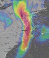 Screenshot 2024-11-08 223059.jpg114.9 KB · Views: 47
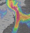 Screenshot 2024-11-08 223117.jpg121.6 KB · Views: 65
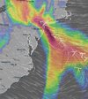 Screenshot 2024-11-08 223135.jpg111.3 KB · Views: 81
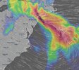 Screenshot 2024-11-08 223207.jpg142.6 KB · Views: 77
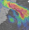 Screenshot 2024-11-08 223223.jpg145 KB · Views: 48


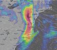
 Impressive process of occlusion of the storm #Ivo crossing Brittany & @paysdelaloire , with the formation of a hook intensifying the precipitation,
  aggravating the historical #crues in Ille-et-Vilaine in particular, & triggering new floods in the Somme.


