Volcanoes Erupting All Over

Grand Solar Minimum Volcanoes Simultaneously Collapsed, Mayan, Roman & Chinese Societies (367) Video 7:36
Jul 3 at 6:26am
https://www.patreon.com/posts/grand-solar-367-12431029?utm_campaign=patron_engagement&utm_medium=post_notification_email&utm_source=post_link
Grand Solar Minimum Volcanoes Simultaneously Collapsed, Mayan, Roman & Chinese Societies in the Late Antique Little ice 535-545 AD. It was a combination of volcanoes erupting in Mexico and New Guinea that are firmly documented. The combination of GSM cosmic ray increases that increased cloud cover, particulates and SO2 in the atmosphere change temperatures and rainfall patterns the world over. We should be preparing for the same volcanism as our Earth enters the new Grand Solar Minimum.
 
While the U.S. has been wrapped up in its never ending Russia drama this week, people in the Mexican town of Pueblo Viejo have had bigger concerns to deal with—like their fear that a volcano might be developing underneath them.

New Volcano? Mexican Villagers Scared After Finding Burned Goats and 480-Degree Soil (Video)
http://www.newsweek.com/mexico-volcano-burned-goats-field-636962

7/15/17 - Suspicion over the formation of a volcano in the Michoacán state started last Sunday, when villagers discovered that some of their goats had been inexplicably burned. Then a nearby soccer field started to break apart, releasing steam, ash and gas into the air, according to Notimex. When alarmed residents contacted authorities, researchers took the temperature of the soil and found it to be roughly 250 degrees Celsius (more than 480 degrees Fahrenheit).

Experts eventually concluded there's probably no volcano coming together underground, given that "until now, there has been no earth movement in the area," as State Civil Protection Coordinator Pedro Carlos Mandujano told Notimex. It's likely just a geothermal phenomenon occurring as the soil is composting, according to the Weather Channel.

Reuters reported that locals still weren't convinced that no natural disaster was on the horizon. Some residents simply evacuated, while others criticized the scientists for not giving them enough information about the underground situation.

"We are afraid that if it is a volcano, all our relatives are here," Pueblo Viejo resident Mayra Amezcua Chávez told El Universal in Spanish. "We will have to go elsewhere to live." http://www.eluniversal.com.mx/articulo/estados/2017/07/11/temen-en-michoacan-la-aparicion-de-un-volcan

People may be on high alert because of Pueblo Viejo's proximity to Parícutin, a cinder-cone volcano about 200 miles away. Parícutin was the first volcano researchers could track for its entire life: It formed suddenly in a cornfield in 1943 and within a year had grown more than than 1,000 feet tall, according to the Smithsonian National Museum of Natural History. It went dormant in 1952.

In total, Mexico has about 3,000 volcanoes because of its location on the Pacific Ring of Fire. One of its most active sites is the Colima volcano, which is on the west coast and erupted as recently as February.
 
Iceland’s largest volcano, Katla, was just moved to yellow status. But that isn’t all that’s concerning. There have also been over 500 earthquakes in Iceland in the last four days.

Iceland Could Be About To Experience A Major Volcanic Eruption
http://www.shtfplan.com/headline-news/iceland-could-be-about-to-experience-a-major-volcanic-eruption_07302017

Experts now believe that a volcanic eruption that could be quite large, may soon occur in Iceland. A series of 40 small earthquakes occurred just North East of Mount Fagradalsfjall two days ago, with the final one felt in Reykjavik, measuring at almost 4 on the Richter scale. Following tremors at Katla in South Iceland and a glacial river flood in Múlakvísl, the Icelandic Met Office has raised the status of the famous volcano on its “Aviation Colour Code Map for Icelandic Volcanic Systems” from green to yellow. People have even been warned to stay away from the Múlakvísl River because of the odor of sulfur.

An earthquake of the magnitude of 3 occurred in the Katla caldera at 00:48 last night followed by a series of smaller tremors. The seismic unrest could be connected to the glacial river flood and not connected to a possible eruption at all but the Iceland Met Office cannot be certain at this point.

Alert code yellow means that the volcano is active but that nothing points to an immenent eruption. If the colour code moves up to orange it means that the volcano is increasing its activity and an eruption is becoming likely. –Iceland Monitor

“It’s quite normal for Reykjanes, there have been a series of quakes there in the past few years,” the Met Office commented. And according to a post on volcano enthusiast site Volcanocafé, eruptions occur in Iceland every three to seven years.

“We have never seen a large powerful intrusion at a Mid Oceanic Ridge at such a well-instrumented place,” Carl Rehnberg wrote on Volcanocafé. “We now know that the initial swarm rapidly transformed from tectonic earthquakes, via volcano-tectonic, to earthquakes consistent with moving magma in a surprisingly short timeframe. As such this is turning into a potential eruption or a state of volcanic unrest.” Rehnberg believes that a major eruption could be just hours away. If, however, the “current unrest” stops, there will be no eruption. But, he explains, “At the intensity and force of the current seismic unrest, it is likely that an eruption will occur if the seismic crisis is prolonged.”

Rehnberg speculates that there is a 50 percent chance of an eruption, and that chance is increasing by the hour. But the Icelandic Met Office, who are currently not concerned about a major volcanic eruption, citing the recent seismic activity as “normal for an active region”.
 
According to the Kamchatka Volcanic Eruption Response Team, Zhupanovsky Volcano could yield ash explosions reaching heights of six to eight kilometers above sea level.

Eruption Begins at Zhupanovsky Volcano in Russia's Far East - Volcano Service
https://sputniknews.com/russia/201709171057460137-eruption-volcano-russia/

Zhupanovsky volcano on Russia's Kamchatka Peninsula is about to burst its top, emitting ash explosions reaching heights of six to eight kilometers (19,700-26,240 feet) above sea level, the Kamchatka Volcanic Eruption Response Team (KVERT) said Sunday.

Moderate activity of the volcano continues. Gas-steam plume was noted on the height up to 4 km a.s.l. Moderate fumarole activity of the volcano continues. Ash explosions up to 19,700-26,240 ft (6-8 km) a.s.l. could occur at any time. Ongoing activity could affect international and low-flying aircraft," KVERT said.

The current aviation color code for this level of activity is yellow, which is the next step up from the safe green and indicates that monitoring continues.

The Russian emergencies service noted that tourist organizations were advised against taking expeditions to the area.

Earlier in September, Sheveluch and Karymsky volcanoes showed signs of activity.
 
Authorities in Indonesia have expanded the "no go zone" at Bali's Mount Agung and sounded off an alert after officials detected an increase in seismic activity.

Increased Seismic Activity at Bali's Mount Agung Volcano Raises Alert
https://sputniknews.com/environment/201709201057537509-increased-seismic-activity-mount-agung-volcano/

Indonesia's National Disaster Mitigation Agency announced Monday that an exclusion zone of nearly five miles would be established around the volcano's crater and would stay in place for at least 14 days.

Harmonic tremors have continued to increase and people are advised to remain alert," Sutopo Nugroho, spokesman for the agency, told The Australian.

Aside from the increased rumblings, the emergency agency reported a 165-foot high blast was observed from the crater.

Though this is the second time authorities have issued an alert since August, local residents were informed by officials to prepare for the worst — if officials sound the alarm again, they may be ordered to evacuate.

The troublesome volcano — situated a mere 45 miles from Kuta, a tourist hotspot — last erupted in 1963, killing roughly 1,100 people.


An international group of scientists warned of catastrophic consequences of a possible eruption of a supervolcano in southern Italy, which they said may be fueled by the so-called 'hot zone' feeding the volcano.

Powder Keg on Fire? Scientists Warn on Catastrophic Volcanic Eruption in Europe
https://sputniknews.com/europe/201709191057525247-italy-volcano-study-eruption/

Scientists declined to elaborate on when the eruption of Campi Flegrei to the west of Naples may occur, but stressed that flows of a magmatic bubble under the volcanic caldera has become more active in the past few weeks, according to the Phys.org website.

The relevant study is led by Dr. Luca De Siena at the University of Aberdeen along with the University of Naples and the University of Texas at Austin.

"One question that has puzzled scientists is where magma is located beneath the caldera, and our study provides the first evidence of a hot zone under the city of Pozzuoli that extends into the sea at a depth of 4 km," De Siena said.

In the 1980s, a spate of small earthquakes took place in the area after the injection of either magma or fluids in the shallower structure of the volcano.

The super eruption of Campi Flegrei occurred about 40,000 years ago and probably caused the beginning a volcanic winter. Ashes covered an area of more than 1.1 million square kilometers at the time, according to the scientists.
 
Alert level for Agung volcano raised to 3 (of 4), Bali, Indonesia
_https://watchers.news/2017/09/19/agung-volcano-bali-eruption-warning/
Posted by TW on September 19, 2017
Snip:
The Alert Level for Agung volcano in Karangasem district of the Indonesian province of Bali was raised from 2 to 3 (of 4) on September 18, 2017, following a sharp increase in volcanic earthquakes on September 17. Authorities raised the alert to 2 on September 14, after an increase in earthquakes first detected on September 13. The last eruption of this volcano started in February 1963 and ended in January 1964. It was one of the world's largest eruptions of the 20th century, with Volcanic Explosivity Index (VEI) of 5.

Volcano eruption after deadly 7.1 magnitude earthquake rocks Mexico
_http://www.dailystar.co.uk/news/world-news/646156/Mexico-City-Earthquake-Volcano-Popocatepetl-7-1-Death-Toll-Magnitude-Eruption
AT LEAST 15 people have been killed after the deadly 7.1 magnitude earthquake that struck Mexico City triggered a volcano eruption.
803129.jpg

Snip:
The mountain is known to be very active and previously had a signficant eruption on August 22, sending a volcanic plume some 4km into the air.

Pictures posted on social media appear to show smoke rising from the peak of the 5,426m tall mountain.
 
Shallow earthquakes near active volcanoes during the past 24 hours
updated: 24 Sep 19:39
https://www.volcanodiscovery.com/earthquakes-volcanoes/past24hours/2017-Sep-24-08.html
earthquakes-volcanoes-last24hrs-1506281958.jpg

https://www.facebook.com/VolcanoMonitor/
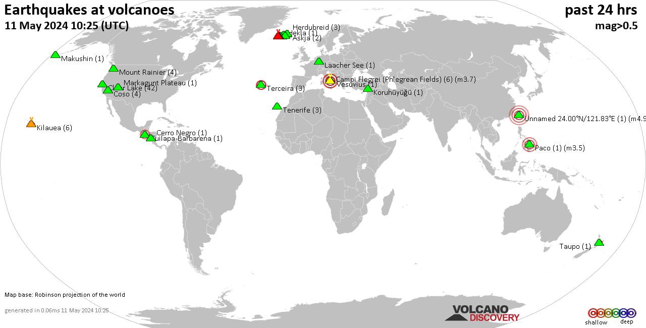
Shallow earthquakes near active volcanoes during the past 24 hours (update 19:39, Sunday, 24 Sep 2017)
Link for links: In Red ( Ring of Fire)

Akyarlar volcano (Turkey): 11 earthquakes of magnitudes between M0.8 and M4.2 at hypocenter depths of 15.7-2.0 km during the past 24 hours

Bardarbunga volcano (Iceland): 2 earthquakes of magnitudes between M1.8 and M2.6 at hypocenter depths of 4.4-1.1 km during the past 24 hours

Brennisteinsfjöll volcano (Iceland): 1 earthquake of magnitude M1.3 at 7.9 km depth 9 hours ago

Cancanajag volcano (Central Philippines): 1 earthquake of magnitude M2.7 at 1.0 km depth 11 hours ago

Clear Lake volcano (California): 12 earthquakes of magnitudes between M0.4 and M1.6 at hypocenter depths of 14.6-0.2 km during the past 24 hours

Coso volcano (California): 2 earthquakes of magnitudes between M0.6 and M1.0 at hypocenter depths of 3.7-2.7 km during the past 24 hours

Grímsnes volcano (Iceland): 1 earthquake of magnitude M0.6 at 0.7 km depth 15 hours ago

Grímsvötn volcano (Iceland): 1 earthquake of magnitude M1.0 at 3.0 km depth 19 hours ago

Katla volcano (Iceland): 3 earthquakes of magnitudes between M0.7 and M1.4 at hypocenter depths of 1.1-0.1 km during the past 24 hours

Kilauea volcano
(Hawai'i (Big Island)): 4 earthquakes of magnitudes between M1.8 and M2.7 at hypocenter depths of 6.4-1.0 km during the past 24 hours

Klyuchevskoy volcano (Central Kamchatka Depression): 1 earthquake of magnitude M0.8 at 1.4 km depth 21 hours ago
Krísuvík volcano (Iceland): 4 earthquakes of magnitudes between M0.4 and M1.3 at hypocenter depths of 8.6-4.4 km during the past 24 hours

Long Valley volcano (California): 4 earthquakes of magnitudes between M0.8 and M2.5 at hypocenter depths of 4.0-1.4 km during the past 24 hours

Mammoth Mountain volcano (California): 6 earthquakes of magnitudes between M0.9 and M2.0 at hypocenter depths of 3.7-0.1 km during the past 24 hours

Mount Rainier volcano (Washington): 7 earthquakes of magnitudes between M0.2 and M1.1 at hypocenter depths of 0.9-0.1 km during the past 24 hours

Nisyros volcano
(Greece): 1 earthquake of magnitude M2.0 at 12.7 km depth 24 hours ago

Reykjanes volcano (Iceland): 3 earthquakes of magnitudes between M0.7 and M2.0 at hypocenter depths of 6.9-0.8 km during the past 24 hours

Salton Buttes volcano
(California): 5 earthquakes of magnitudes between M1.2 and M2.0 at
hypocenter depths of 2.1-1.0 km during the past 24 hours

Theistareykjarbunga volcano (Iceland): 1 earthquake of magnitude M0.9 at 4.2 km depth 32 minutes ago

Ugashik-Peulik volcano (Alaska Peninsula): 1 earthquake of magnitude M2.7 at 0.6 km depth 15 hours ago

Vatnafjöll volcano (Iceland): 1 earthquake of magnitude M1.9 at 10.0 km depth 10 hours ago

Note: This is not a complete list because some areas (e.g. N-America, Europe, NZ) have much better coverage of small earthquake detection than others.
 
Indonesian Bali's volcano is tremoring almost 500 times per day, local media reported Tuesday, citing Indonesian disaster agency.

Indonesian Volcano Sending Out Powerful Shakes 500 Times per Day
https://sputniknews.com/asia/201709261057694546-indonesia-bali-volcano-eruption/

Mount Agung volcano on Indonesia's Bali island has reached a critical stage with almost 500 tremors recorded per day, local media reported Tuesday, citing Indonesia's National Disaster Mitigation Agency (BNPB).

"No one can predict when [eruption will occur] exactly. But for now, we can say all measuring instruments show there is growing pressure towards the surface," BNPB spokesman Sutopo Purwo Nugroho said, as quoted by the media.

On Friday, the BNPB raised the volcano alert for the island's highest mountain, Mount Agung, to Category 4, the highest level of alert warning that an eruption could be "imminent." Nearly 48,000 villagers residing next to the mountain have been evacuated.


Vanuatu locals were evacuated due to the high possibility of the upcoming volcano eruption.

Over 6,000 People Evacuated in Vanuatu Over Volcano Eruption Alert
https://sputniknews.com/asia/201709261057695524-vanuatu-volcano-eruption-evacuation/

Authorities in the South Pacific archipelago nation of Vanuatu have evacuated more than 6,000 people in connection with the likely eruption of Manaro (Monaro) volcano, the country’s Disaster Management Office (NDMO) said Tuesday.

"The evacuation process is still going on – maybe today or tomorrow it will be completed … The indication that came in is that we’ve moved over 6,000 people already," NDMO Director Shadrack Welegtabit said, as quoted by Vanuatu Independent Online.

Last week, the activity of Manaro on the island of Ambae sharply increased, and the volcanic alert level was raised to level 4 out of 5. Consequently, the Vanuatu government declared a state of emergency on the island, which has a total population of about 10,000. The population of the country is less than 300,000; 65 of the nation's 82 islands are inhabited.
 
The Fuego Volcano in south Guatemala explodes one of "the largest recorded eruptions" in the volcano's history
http://www.thebigwobble.org/2017/10/the-fuego-volcano-in-south-guatemala.html

The Fuego Volcano in south Guatemala burst into life on Wednesday plumes of ash blew into the sky in what has been described as one of "the largest recorded eruptions" in the volcano's history.

The volcano, known locally as Volcan de Fuego, which translates as 'Volcano of Fire', is an extremely active volcano, and this is the seventh time this year that it has erupted.

Guatemala's National Institute of Seismology, Volcanology, Meteorology and Hydrology (Insivumeh) stated that ash has been spread 20 kilometres in east and northeast directions.

Authorities have also warned that ash could spread all the way to Guatemala City, the capital of Guatemala, some 50 kilometres northwards of the volcano.

Insivumeh warned that "in the eruptive behaviour of the volcano and the variability of the wind, experts do not rule out the possibility that this activity will continue to make ash fall at greater distances".

Guatemala's Volcano Observatory added: "These explosions are of a weak, moderate and strong character, expel columns of grey ash at a height of 4400-5,000m (14435-16,405ft) and are driven by the wind at distances ranging from 16-20km to the east, northeast".

Authorities have also alerted aviation bosses to warn them about the plumes of ash which could cause travel chaos.

The Civil Aeronautics said: "This is one of the largest recorded eruptions of the volcano of Fuego, so it is not appropriate to ascend to any flank of the volcano of Fuego."

The 3,800 metre tall Volcan de Fuego is one of South America's most active volcanos, which is some feat as the continent is dotted with them and over 30 in Guatemala alone.

This is the seventh eruption of the year, but experts say that this is no cause for concern as it has been blowing regularly since the Spanish conquest.
 
For the first time in six years the Shinmoedake volcano, situated in between Japan's Kagoshima and Miyazaki prefectures, erupted early Wednesday, prompting officials to raise its volcanic alert rating to Level Three.

Japan's Shinmoedake Volcano Makes First Eruption in Six Years (PHOTOS, VIDEOS)
https://sputniknews.com/asia/201710121058150908-japan-shinmoedake-volcano-first-eruption-six-years/

Working on a five-point scale, the current status commands locals to steer clear of the crater. The highest rating, a five, would trigger a mandatory evacuation of the region.

Restricting residents from Mount Shinmoedake's crater, the Japan Meteorological Agency reported that upwards of 100 volcanic earthquakes were observed since October, the Japan Times reported. On October 5, 90 small tremors were reported near the mountain.

​According to reports, the volcano began to spew smoke and ash at roughly 5:34 a.m. local time, and a volcanic plume rose about 300 meters above the crater. Citing local police, the outlet added that ash fell on a town in Miyazaki but no injuries or damages were reported.

The meteorological agency later warned that the situation could worsen as researchers noted that the mountain was "swelling."

​Recalling the last eruption that residents witnessed, Yoshinari Imanishi, a 66-year-old official in Takaharu, told the media he was concerned about the effects the volcano could have on the local tourism industry.

"We were hit by cancellations of accommodations [for] six years," Imanishi told Kyodo News. "I hope [the eruption] will not affect autumn outing season."

​According to the Times, the agency lowered the volcano's alert level from two to one on May 26 after its volcanic activity at the time had ceased.

The the last major eruption of Shinmoedake was on January 2011, and prolonged volcanic activity had officials paying close attention to the site for much of the year after the volcano erupted for a second time on September 7, 2011.
 
One of Iceland's largest volcanoes is approaching a major outbreak, which might be its first in several centuries. Its aftermath might well compare with that of the notorious Eyjafjallajökull eruption in 2010, which left air traffic grounded throughout much of Europe.

Alert as Iceland's Largest Volcano Awakes After 290 Years of Dormancy
https://sputniknews.com/viral/201711221059326926-iceland-volcano-eruption/

The ice-covered Öræfajökull volcano, which has been dormant since 1727, has recently woken from its slumber and experienced a major earthquake on October 3.

Since then, increased biothermic activity has caused ice to melt and form lakes around the volcano. The melting water reported reeks of sulfur, which might be yet another token of the activity.

"Even in the last few days, there have been tremors, albeit smaller ones. Something is going on there which has not happened before, and therefore the observations about the volcano are increasing," seismologist Reynir Bödvarsson of Uppsala University told the Swedish Aftonbladet daily.

​Icelandic authorities have raised the warning level to code yellow. In addition to putting inhabitants in nearby villages under threat, an eruption could possibly endanger air traffic the way it did during the Eyjafjallajökull eruption in 2010, when about 20 countries closed their airspace to commercial jet traffic, affecting about 10 million travelers.

"There may be an explosive outbreak of ash, similar to what happened in Eyjafjallajokull, which could affect air traffic. Several Icelandic volcanoes are capable of that. And it is actually quite possible that such an outbreak will last longer, as the outbreak of 2010 was but a small one, even though it had these consequences," Bödvarsson said.

At 2,110 meters, Öræfajökull is the highest point in Iceland. Its last eruption occurred in 1727, and the last outbreak before that happened in 1362 and is considered to be the second most deadly in the history of the island nation, rendering its Litla Hérað farmland into a lava desert.

In addition to Öræfajökull, several other Icelandic volcanoes are verging on eruption. Of late, increased pressure has been observed in Bárðarbunga and Grímsvötn underneath Vatnajökull glacier, which are both recharging and most probably preparing for the next chapter in volcanic activity, Páll Einarsson, geophysicist at the geological science department of the University of Iceland, told the local newspaper Morgunblaðið.

Also Hekla, Iceland's most famous volcano, is experiencing mounting pressure since its latest eruption in the year 2000.

"It would come as a surprise to no one if Hekla blows soon. However, it could also drag on for a while. We don't really know how long volcanoes can endure expansion of gases without this coming to an eruption," Einarsson said.

​This take was shared by his colleague Bödvarsson.

"Even if an outbreak is underway, it may take weeks, months, years or decades," Bödvarsson said.

Iceland has 32 active volcanoes.
 
Indonesia’s Mount Agung volcano on the island of Bali erupted for the second time in less than a week on Saturday evening, emitting a thick plume of ash and smoke more than 1,500 m (4,921 ft) into the sky, forcing Airlines have been forced to change their flight plans media reports said.

Facing Fresh Bali Volcano Eruption Red Warning Issued to Airlines (VIDEO)
https://sputniknews.com/asia/201711261059442283-volcano-eruption-airlines/
https://www.youtube.com/watch?v=7M766XE4hGE (1:39 min.)

Airlines have been issued a “red warning” about the danger of volcanic ash choking and shutting down plane engines as another eruption looks imminent.

After Saturday’s eruption, which produced a bigger ash cloud than the initial one on Tuesday, Singapore updated its travel advisory for the island, warning that ash clouds could “severely disrupt air travel.”

Meanwhile, Indonesia’s Disaster Mitigation Agency said that “tourism in Bali is still safe, except in the danger (zone) around Mount Agung," referring to an area that extends to a radius of up to 7.5 km (4.7 miles) from the summit, the BBC reported.

According to media reports, an estimated 25,000 people still live in temporary shelters after increased volcanic activity prompted fears of a major eruption forcing 140,000 local residents to flee the area.

The Mt. Agung volcano, which towers over eastern Bali at a height of just over 3,000 meters (9,800 feet), is about 70 kilometers (43 miles) from the island’s main tourist areas of Kuta and Seminyak.

During its last eruption in 1963 it left more than 1,000 people dead and destroyed several villages.

Many of Indonesia’s 130 volcanoes show high levels of activity.
 
angelburst29 said:
Facing Fresh Bali Volcano Eruption Red Warning Issued to Airlines (VIDEO)
https://sputniknews.com/asia/201711261059442283-volcano-eruption-airlines/
https://www.youtube.com/watch?v=7M766XE4hGE (1:39 min.)

Mount Agung's volcano continues to erupt as residents and vacationers alike anxious to flee Indonesia's most popular international tourist destination for safety.

Bali Airport Closed Third Day as Tropical Paradise Endures Volcano's Wrath (Video)
https://sputniknews.com/asia/201711291059524155-bali-island-volcanic-eruption-airport/

Mount Agung has spewed ash 7,600 meters (4.7 miles) into the sky, prompting the closure of Bali island's international airport for a third day.

About 60,000 passengers remain stranded; over 440 flights have been canceled, The Telegraph cited airport spokesman Ari Ahsanurrohim as saying on Wednesday.

The newspaper also referred to Indonesian volcanologist Gede Swantika, who has warned of a thermal anomaly in the volcano's crater which was detected by a NASA satellite.

According to him, it means that it will be easier for magma to foray to the surface in the immediate future.

Earlier this week, the alert status of Mount Agung was upgraded from level three to level four (the highest possible level) as local authorities ordered the evacuation of almost 100,000 people within the 10 kilometer area around the volcano.

Volcanologists, however, warned of an imminent larger eruption.

Mount Agung last erupted in 1963, killing around 1,600 people.

It has been rumbling for weeks, and in the last few days has begun shooting ash columns and clouds into the sky.

About 40,000 people have already been evacuated from the eruption area but others haven't left "because they feel safe or don't want to abandon their livestock." The island is approximately half the size of Los Angeles County and home to 4.225 million people.
 
Indonesia’s Mount Sinabung erupted Wednesday afternoon, leaving a thick cloud of smoke over parts of the country’s North Sumatra province. The active volcano spewed ash up to 4.6 kilometres into the sky, Reuters reported. Officials tweeted that there were no deaths caused by the explosion because the red zone has already emptied. Thousands of FAMILIES will be relocated from Sinabung. Meanwhile, a thick rain of ash fell on villages East of the volcano.

Sinabung volcano erupts spewing ash up to 4.6 kilometers into the sky and large pyroclastic flows hurtling down the flanks (Photos - Videos)
http://strangesounds.org/2017/12/sinabung-volcano-erupts-spewing-ash-up-to-4-6-kilometers-into-the-sky-and-large-pyroclastic-flows-hurtling-down-the-flank-pictures-and-videos.html
https://www.youtube.com/watch?v=4oFunAo-LCU (1:53 min.)

The first flow spread 3.5 km to the east, the second flow spread 4.5 km to the southeast.
 
Back
Top Bottom