Volcanoes Erupting All Over

Re: More volcanic eruptions

Campi Flegrei is one of world's most dangerous super volcanoes, and now scientists warn that it has reached critical phase and could erupt, which would mean apocalyptic consequences.

Scientists warn: Super volcano has reached critical phase
http://speisa.com/modules/articles/index.php/item.3545/scientists-warn-super-volcano-has-reached-critical-phase.html

A super volcano is defined as a volcano that is able to sling more than than 1,000 cubic kilometers of mass into the atmosphere.

By comparison, one of the most violent eruptions in modern times, Karakatau in 1883, erupted with some 30 cubic kilometers "ejekta".

The result of such large amounts of dust, ash and gas in the atmosphere are equivalent to a so-called nuclear winter: Damaged crops, food shortages, poisoning and general societal collapse.

Two days before Christmas Eve, a research report was published in the science magazine Nature Communications, where they do not hold back:

There are chances that Campi Flegrei is about to erupt. And even worse: It is possible that the dormant super volcano will go into a so-called critical phase.

The first, and perhaps biggest problem is that Campi Flegrei is located just off the city of Naples in Italy, and that around half a million people live more or less directly above the volcano.

The second is that Campi Flegrei is huge. Very big. Unlike several other super volcanoes, Campi Flegrei is not a classic mountainous-shaped hill.

Large parts of the volcano is actually submerged in the Mediterranean, and in total it consists of 24 craters, several geysers and large warm areas.

The name Campi Flegrei actually means "burning plains", and the caldera, or crater, is an entire 7.5 km in diameter.

The largest eruption occurred about 200,000 years ago and led to large climate changes throughout Europe. Since, Campi Flegrei has had several eruptions, for 40,000, 35,000 and 12,000 years ago.

The eruption 40,000 years ago is tied to the extinction of neanderthals, although it is difficult to ascertain something that happened so long ago.

Now Italian authorities have upgraded the threat level from green to yellow, which in practice means that the volcano is to be monitored.

And much more it is no possible to do. The power of a super volcano is so large that any human efforts and countermeasures will amount to nothing.

All we can do is wait, and hope the apocalypse doesn't happen any time soon, because after all, we are living on a bomb.
 
Re: More volcanic eruptions

Etna (Italy) awakens after 8 months, Colima (Mexico), Ebeko (Russia) and Sabancaya (Peru) strongly erupt. (Videos)
http://strangesounds.org/2017/01/etna-italy-awakens-after-8-months-colima-mexico-ebeko-russia-and-sabancaya-peru-strongly-erupt.html

There is no rest!

On January 23, 2017, at sunset, small strombolian explosions were reported at the south-east crater. This is the first volcanic activity of Etna in the last 8 months.

The above video shows one of the small explosions from the “saddle vent” between Etna’s old and new Southeast Crater at sunset, 23 January 2017.

This perfect ring of steam was created by Etna on January 19, 2017.

Meanwhile in Mexico, the Colima volcano erupted violently again at 15:47 with plumes of ash and gas rising to more than 3,000 meters above the summit.

The Ebeko volcano in the Kuril Islands erupted on January 23, 2017. It was filmed using a drone in this great footage showing the volcanic peak emitting huge volumes of smoke and ash in the air.

Officials recommend not to get too close to the volcano as it may eject fairly large fragments of solid volcanic rock, even at a considerable distance. Ashfall was reported in the town of Severo-Kurilsk.

At Sabancaya in Peru, earthquakes associated with magmatic movements (LP, tremor and hybrids) were elevated with 2 VT earthquakes (M3.5 and M3.7) hitting just several kilometers north of the crater. This week, there were 76 daily explosions on average.

The eruptive plumes reached 2,500 meters above the crater, spreading over more than 40 km in the direction of S and SO.
 
Mt Etna eruption LIVE: Lava spewing from Europe’s highest & most active volcano
https://www.youtube.com/watch?v=9ydsEtQDDoo

RT Streamed live 23 hours ago

Europe’s highest active volcano Mount Etna erupts in Sicily.


MT. Etna Erupts/Ash Warning Map.
BPEarthWatch
https://www.youtube.com/watch?v=qsdZp3Uqt3c (4:13 min.)
 
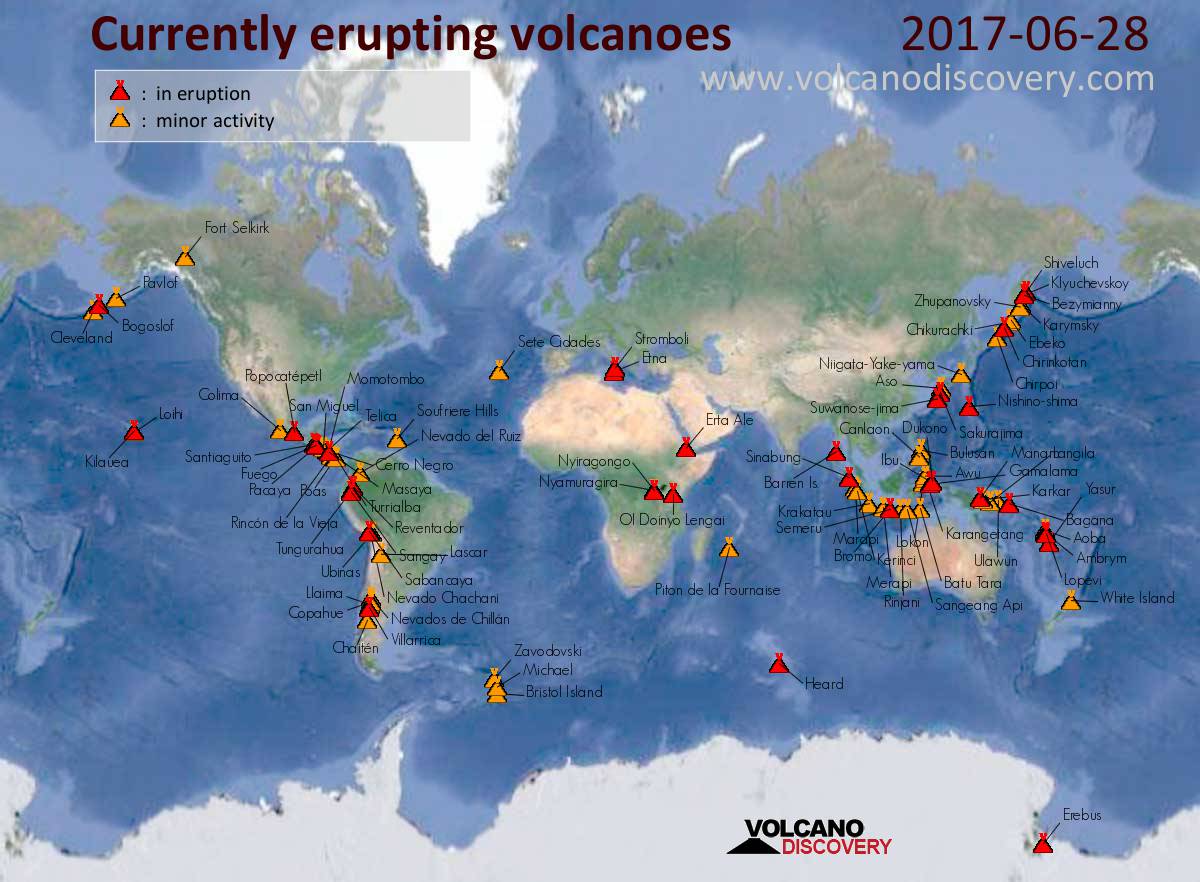
According to the Volcano Discovery site, 35 volcanoes are either currently erupting right now or just recently erupted all over the world. There are even more volcanoes with eruption warnings and tons of other volcanoes that are active, meaning they could technically erupt at any minute (though unlikely).

_https://www.volcanodiscovery.com/erupting_volcanoes.html
 
At least 10 people were injured after Mount Etna erupted on Italy's island of Sicily, local media reported Thursday.

At Least 10 People Injured in Mount Etna Eruption
https://sputniknews.com/europe/201703161051651630-mount-etna-eruption/

According to the ANSA news agency, people, who were on the Mount Etna, suffered minor injuries and concussions after the eruption.

The news outlet added that six of the injured people had already been sent to the hospitals of Catania and Acireale cities.

Mount Etna is a volcano, which is the largest in Italy and is considered to be the most active in Europe. The activities of the volcano, which is registered on the UNESCO World Heritage List, have been documented for at least 2,700 years, according to the UNESCO.
 
AN ACTIVE island volcano situated in the Pacific Ocean under one of the world’s busiest flight paths has barely stopped erupting since Christmas and is nearing its 40th explosion in months.

‘Explosive events’ rock Pacific Ocean
http://www.news.com.au/technology/environment/natural-wonders/explosive-events-rock-pacific-ocean/news-story/618b9ee04ece0d80e69c02ebe5c92d94

Bogoslof volcano, nestled in the Aleutian Islands about 98km northwest of Dutch Harbor, Alaska, US, has been in the midst of an “active eruption sequence” since mid-December 2016.

It has erupted more than 37 times since then and sent up another ash cloud as recently as Monday. The Alaska Volcano Observatory said the latest eruption lasted 12 minutes.

The observatory said the magnitude of the eruption was being monitored.

Monday’s eruption of the volcano did not immediately prompt an aviation warning for pilots although another explosion the previous week saw authorities issue a warning about ash at elevations that could affect flights.

The recent Bogoslof volcano eruptions have each lasted on average about 30 to 60 minutes with volcanic ash spewed to altitudes exceeding 30,000 feet.

“Eruptive activity has been dominated by a series of explosive events originating from below sea level,” according to the US Geological Survey (USGS).

“(That has) resulted in drifting clouds of ash that threaten not only local air traffic, but also wide-body jets flying between North America and Asia.

“The most significant — and common — hazards from Alaska volcanoes are those created by ash clouds and ash fall.”

Alaska’s volcanoes lie under Pacific aircraft routes and can erupt ash clouds into commercial and recreational airspace.

Bogoslof’s periodic eruptions have prompted warnings to airliners and a major US fishing port in the Aleutian Islands.

“Ash and aircraft do not mix, as volcanic ash is abrasive, melts at jet engine temperatures, and can cause engine failure,” a US Geological Survey spokesperson said.

“North Pacific and Russian Far East air routes pass over or near more than a hundred potentially active volcanoes. Aircraft flying along these routes, some of the busiest in the world, carry more than 50,000 passengers and millions of dollars of cargo each day to and from Asia, North America, and Europe.

“In the North Pacific region, several explosive eruptions occur every year. Ash from these eruptions, which has caused jet engines to fail, is usually blown to the east and northeast, directly across the air routes.”

Ash clouds rising above 20,000 feet are a threat to jets flying between Asia and North America.

Volcanic ash can erode jet engine turbine blades. Ash melted by high temperatures in the engines adheres to critical parts and can cause engine failure, according to the observatory. Ash can also scrape cockpit windows and interfere with electronics of navigation systems.

It is uncertain how long eruptions of Bogoslof will continue, according to the US Geological Survey. Some volcanoes, including Vanuatu’s Mount Yasur and Italy’s Mount Etna have continuously erupted for more than a century.

The National Weather Service warned that trace amounts — less than one millimetre — of ash from the recent eruptions could settle on Dutch Harbor, a major port for Bering Sea crab and pollock.

US Geological Survey geologist Kristi Wallace said the 36th eruption was “the most significant event for the entire eruption” and took place earlier this month.

Ms Wallace said the eruption was marked by 200 lighting strikes and elevated seismic activity that lasted for days. “And then it just shut off,” she said.

The current eruptions are from a shallow, underwater vent on the island’s southeast side.

Bogoslof Island is the tip of an underwater volcano that extends down 5,500 feet in a cone shape to the floor of the Bering Sea. The island first appeared after an underwater eruption in 1796. Subsequent explosions and eruptions have caused the island to grow and shrink.

The volcano remains in a heightened state of unrest and could erupt again at any time.

Fine ash drifting to cities can cause respiratory problems for people and animals, interfere with electrical equipment and damage air filters and gasoline engines.

Ms Wallace said the observatory had received reports of light dustings of ash in the Unalaska and Dutch Harbor, Alaska, about 100km southeast of the volcano.

The community is home to about 4500 people but winds have reportedly blown the ash cloud away from the island.

Unalaska Department of Public Safety communication officer Donnie Lane said police had not received any reports of ash falling on the community.
 
The Kambalny volcano on the Kamchatka peninsula has started spewing ash after waking from a 250 year period of inactivity.

Kamchatka Volcano Awakens From 250-Year Slumber Spewing Huge Ash Plume (Video)
https://sputniknews.com/russia/201703251051959085-kamchatka-volcano-eruption/
https://www.youtube.com/watch?v=CEkSNyeihPc (1:00 min.)

The area around the Kambalny volcano in Kamchatka has been put on alert after the volcano started spewing ash for the first time in over 200 years, RIA Novosti reported on Saturday.

Kambalny, which has a height of 2,156 meters above sea level, began spewing ash on Friday evening. The ash rose to a height of 7,000 meters above sea level and traveled a distance of 255km in a south-westerly direction.

The Kamchatka Volcanic Eruption Response Team (KVERT) of the Russian Academy of Sciences' Institute of Volcanology and Seismology has notified air traffic controllers of the danger of a volcanic eruption.

The volcano has been assigned an orange aviation color code, which means that the volcano is exhibiting heightened unrest with increased likelihood of eruption.

Residents in the village of Ozernovskiy, the nearest settlement located 77 km away from the volcano, have been informed of the threat.

"No tourist groups have been registered in the region of the volcano," the local Ministry of Civil Defense, Emergencies and Disaster Relief (MChS) told RIA Novosti.

The Kambalny volcano is the southernmost active volcano on the Kamchatka peninsula. According to data from the Institute of Volcanology and Seismology, the volcano last erupted in 1769.

There are more than 300 volcanos on the Kamchatka peninsula, 29 of which are thought to be active. In December, the northernmost volcano on the territory, Shiveluch, erupted and spewed ash to a height of 11,000 meters above sea level.
 
Re: More volcanic eruptions

angelburst29 said:
Campi Flegrei is one of world's most dangerous super volcanoes, and now scientists warn that it has reached critical phase and could erupt, which would mean apocalyptic consequences.

Scientists warn: Super volcano has reached critical phase
http://speisa.com/modules/articles/index.php/item.3545/scientists-warn-super-volcano-has-reached-critical-phase.html

Another article on Campi Flegrei:

A new study from University College London (UCL) has suggested that Europe’s only supervolcano, in Italy, may soon erupt once more, for the first time in half a millennium.

Red Alert: Europe’s Only Supervolcano May Erupt Soon
https://sputniknews.com/europe/201705161053646690-italy-supervolcano-may-erupt-soon/

Campi Flegrei, whose name is Italian for "Burning Fields," is a massive depression in the Earth flooded by water. It is located in the Gulf of Naples,
which means a catastrophic eruption could endanger the three million people who live in the metropolitan area of Italy's second biggest city.

The volcano's restlessness began in in the 1950s, with minor earthquakes and uplift. A similar phenomenon occurred in the 15th century, leading up to the volcano actually erupting in 1538. The authors, who published their findings in Nature Communications, used a new model of volcanic fracturing to determine the chances of an eruption.

The new study found that the unrest since the 1950s has had a cumulative effect, with more and more energy building up in the crust and increasing the chances for an eruption. Previously, it was believed the energy diffused after each bout of unrest.

"By studying how the ground is cracking and moving at Campi Flegrei, we think it may be approaching a critical stage where further unrest will increase the possibility of an eruption, and it's imperative that the authorities are prepared for this," said Dr. Christopher Kilburn, Director of the UCL Hazard Centre, in a statement.

"We don't know when or if this long-term unrest will lead to an eruption, but Campi Flegrei is following a trend we've seen when testing our model on other volcanoes… We are getting closer to forecasting eruptions at volcanoes that have been quiet for generations by using detailed physical models to understand how the preceding unrest develops."

Already, the unrest has caused issues in Italy. In the 1980s, seismic unrest from Campi Flegrei lowered sea levels by two meters and sent tremors through the nearby city of Pozzuoli, displacing 36,000 people and damaging 8,000 buildings.

"Most damage in previous crises was caused by the seismic shaking of buildings. Our findings show that we must be ready for a greater amount of local seismicity during another uplift and that we must adapt our preparations for another emergency, whether or not it leads to an eruption," said study co-author Professor Giuseppe De Natale.

In 2005, a tectonic uplift began that slowly began to raise underwater volcanoes to the surface. The trend has continued without ever stopping, and in 2012 volcanologists changed Campi Flegrei's monitoring status from green to yellow, meaning it must be persistently and actively monitored.

Since then, uplift and seismic activity have only continued to mount. The sheer size of the makes the notion of an eruption somewhat unnerving. The last time Campi Flegrei underwent a major eruption was in 37,000 BC, a blast so massive that some anthropologists believe it led to the extinction of the Neanderthals in Europe.
 
West Coast Seismic Alert: 2 Alaskan Volcanoes Erupt As Earthquake Swarms At Mount St. Helens Raise Concerns
http://theeconomiccollapseblog.com/archives/west-coast-seismic-alert-2-alaskan-volcanoes-erupt-as-earthquake-swarms-at-mount-st-helens-raise-concerns

By Michael Snyder, on May 18th, 2017

Mount St. Helens, Mount Rainier and Mount Hood are all major volcanoes that lie along the infamous “Ring of Fire” that runs down the west coast of the United States, and all of the seismic activity that has been taking place in the region has many concerned about what may happen next. Earlier this month, I wrote about how 45 earthquakes of magnitude 2.5 or greater hit Alaska in just one 24 hour period. This week, it is volcanic activity that is raising concerns. The earthquake swarms at Mount St. Helens are making headlines all over the globe, and on Tuesday two major volcanoes in Alaska suddenly erupted on the exact same day…

An eruption at Bogoslof volcano – one of two to erupt in the Aleutian Islands Tuesday – is its first after more than two months of inactivity, causing ash to fall in a nearby community before drifting south over the Pacific Ocean.

The Alaska Volcano Observatory said Tuesday night’s eruption at the volcano about 60 miles west of Unalaska, which began just after 10:30 p.m. and lasted for 73 minutes, sent a plume to an altitude of 34,000 feet.

Overall, 39 volcanoes around the world are either erupting right now or have recently erupted according to Volcano Discovery.

Most of those active volcanoes are along the Ring of Fire.

Fortunately, the U.S. portion of the Ring of Fire has been less active than other areas in recent years. But experts assure us that will eventually change because seismic tension continues to build. One example of this is what is happening at Mount St. Helens right now. According to scientists, the famous volcano is currently going through what is known as a “magma recharge”…

Since mid-April, small earthquakes have been cropping up deep beneath Mount St Helens at ‘relatively high rates,’ bringing roughly one tremor every few hours.

In the last 30 days, scientists have located 55 seismic events in the vicinity, and say there may be well over 100 earthquakes linked to the swarm so far.

The activity falls in line with magma recharge thought to be underway since 2008.

Someday it will erupt again, and the geologists that monitor these things are watching the latest developments very carefully…

“Mount St. Helens is at normal background levels of activity,” Liz Westby, a geologist with the U.S. Geological Survey–Cascades Volcano Observatory, told ABC News. “But a bit out of the ordinary are several small magnitude earthquake swarms in March to May 2016, November 2016 and April 16 to May 5, 2017. During the April 16 to May 5, 2017, swarm, we detected well over 100 earthquakes, all below a magnitude 1.3.”

Personally, I am much more concerned about Mount Rainier than I am about Mount St. Helens. Since the last time it erupted in the late 19th century, hundreds of thousands of people have moved into the danger zone around the volcano, and a full-blown eruption now would eclipse any other natural disaster in recorded U.S. history.

Over the last 30 days, there has also been a good bit of seismic activity at Mount Rainier, and much of it has been centered right along the core of the volcano…

Mount Rainier is capable of unleashing a flow of super-heated mud that could literally cover much of the Seattle/Tacoma area. If you think that I am exaggerating, please see the following excerpt from Wikipedia…

Mount Rainier is currently listed as a Decade Volcano, or one of the 16 volcanoes with the greatest likelihood of causing great loss of life and property if eruptive activity resumes.[45] If Mt. Rainier were to erupt as powerfully as Mount St. Helens did in its May 18, 1980 eruption, the effect would be cumulatively greater, because of the far more massive amounts of glacial ice locked on the volcano compared to Mount St. Helens,[37] the vastly more heavily populated areas surrounding Rainier, and the simple fact that Mt Rainier is a much bigger volcano, almost twice the size of St. Helens.[46] Lahars from Rainier pose the most risk to life and property,[47] as many communities lie atop older lahar deposits. According to the United States Geological Survey (USGS), about 150,000 people live on top of old lahar deposits of Rainier.[7] Not only is there much ice atop the volcano, the volcano is also slowly being weakened by hydrothermal activity. According to Geoff Clayton, a geologist with a Washington State Geology firm, RH2 Engineering, a repeat of the Osceola mudflow would destroy Enumclaw, Orting, Kent, Auburn, Puyallup, Sumner and all of Renton.[36] Such a mudflow might also reach down the Duwamish estuary and destroy parts of downtown Seattle, and cause tsunamis in Puget Sound and Lake Washington.[48] Rainier is also capable of producing pyroclastic flows and expelling lava.[48]

I keep warning about the dangers of a future eruption of Mount Rainier, and this is something that is so heavy on my heart that I even included an eruption of the volcano in my novel entitled The Beginning Of The End. If you live in the Seattle/Tacoma area, you need to have a plan for a very rapid evacuation in the event a major eruption suddenly takes place.

On the other side of the world, scientists are warning that a supervolcano near Naples, Italy is reaching a critical stage. The following comes from Newsweek…

One of the world’s most dangerous supervolcanoes appears to be closer to erupting than we once thought, scientists have warned. Campi Flegrei in southern Italy has been showing signs of reawakening over the past 67 years, and new research indicates the volcano has been building energy throughout this period, increasing the risk that it will erupt.

Campi Flegrei is a huge volcanic field that sits about 9 miles to the west of Naples, a city home to over a million people. It is made up of 24 craters and edifices, and appears as a large depression on the surface of the land.

The volcano last erupted in 1538 after almost a century of pressure building up. But though it lasted over a week, this was a comparably small one—40,000 years ago, it produced a “super-colossal” eruption. This is the second highest measure on the volcanic explosivity index, the first being “mega-colossal,” like those seen at the Yellowstone supervolcano in the U.S. thousands of years ago.

For years I have been documenting how the crust of our planet is becoming increasingly unstable, and at some point a major seismic event is going to dramatically change life in America overnight.

Let us hope that day is delayed for as long as possible, but as certainly as you are reading this article it is coming.

Thirty-seven years ago, Mount St. Helens erupted in Washington, spewing ash, rock, and hot gasses into the air and causing mud to flow down the mountainsides.

Mount St. Helens: Remembering the deadliest U.S. volcanic event 37 years later (Photos - Video)
http://www.king5.com/news/local/mount-st-helens-remembering-the-deadliest-us-volcanic-event-37-years-later/440644176
https://www.youtube.com/watch?v=yNJGqtvWm2g (2:02 min.)

The eruption took place on May 18, 1980, at 8:32 a.m. PDT and was "the deadliest and most economically destructive volcanic event in the history of the United States," according to the National Oceanic and Atmospheric Administration.

The eruption killed 57 people and caused more than a billion dollars in damage. Ash blanketed the Pacific Northwest and stretched into 11 states and Canada. Fatalities included photojournalist Reid Blackburn, a USGS volcanologists named David Johnston and Harry Truman, a lodge owner in his 80s who rose to fame after he refused to leave the mountain in the weeks preceding the eruption.

Autopsies showed that most of the people killed in the eruption likely died from asphyxiation after inhaling hot ash, according to the USGS.

Truman, who owned a lodge on Spirit Lake for more than 50 years, gave colorful interviews to the press.

"I'm going to stay right here because, I'll tell you why, my home and my (expletive) life's here," he told National Geographic in an interview before the disaster. "My wife and I, we both vowed years and years ago that we'd never leave Spirit Lake. We loved it. It's part of me, and I'm part of that (expletive) mountain," he said.

Witnesses share their stories (Article continues.)
 
A volcano an Alaska’s Aleutian island chain erupted, sending a plume of ash at least 35,000 feet in the air and prompting a temporary aviation alert, state officials said.

Alaskan volcano erupts, sending ash 35,000 feet into air
http://www.upi.com/Top_News/US/2017/05/29/Alaskan-volcano-erupts-sending-ash-35000-feet-into-air/3211496059584/

The Alaska Volcano Observatory recorded a "significant explosive eruption" starting at 2:16 p.m. Sunday. Bogoslof Volcano, located on the island of the same name, may have sent ash up to 45,000 feet into the air.

"An observer on Unalaska Island reported seeing a large white-gray mushroom cloud form over Bogoslof, with ash fallout to the west," the agency reported.

Officials raised the aviation alert in the area to a code red, but downgraded it to an orange after the eruption subsided.

"We actually went to color code red this afternoon because of numerous lightning detections and increased seismic signals," Jeffrey Freymueller of the Geophysical Institute at the University of Alaska, Fairbanks told CNN. "Lightning in the Aleutians is mostly due to volcanic plumes, as the meteorological conditions for lightning are not common."

An eruption earlier this year changed the shape and coastline of Bogoslof Island, and eruptions since 2015 have caused its landmass to triple in size, CNN reported.
 
A major eruption started at Russia's Sheveluch volcano at 16:20 UTC on June 14, 2017. KVERT reports a plume of ash reached a height of 12 km (39 360 feet) above sea level and warned explosions up to 15 km (49 200 feet) could occur at any time. The Aviation Color Code was raised from Orange to Red.

Powerful eruption of Sheveluch volcano sends ash to 12 km (39 360 feet) a.s.l. (Photos - Video)
https://watchers.news/2017/06/15/sheveluch-eruption-june-14-2017/
https://www.youtube.com/watch?v=uvZPlfO7gjM (0:10 min.)

At 19:00 UTC, vast ash cloud (140 x 60 km / 87 x 37 miles) from the eruption was observed about 64 km (40 miles) to the southwest and 76 km (47 miles) to the northwest from the volcano, KVERT said at 19:32 UTC. By 20:20 UTC, ash cloud grew to 196 x 223 km (122 x 138 miles). Front of ash cloud with a large content of ash particles (67 x 54 km / 41 x 33 miles) was observed about 96 km (59 miles) north-northwest of the volcano, but the other front of ash cloud was 118 km (73 miles) southwest of the volcano.

By 22:30 UTC, ash cloud grew to 422 x 155 km (262 x 96 miles / 36 000 km2 / 13 900 mi2). Ash cloud with a large content of ash particles (84 x 55 km / 52 x 34 miles) was observed 131 km (81 miles) to the north-northeast. A general front of the largest ash cloud was observed 225 km (140 miles) to the northeast, and the other about 194 km (120 miles) to the southwest. By 06:00 UTC, the front of first ash plume was about 640 km (398 miles) to the ENE of the volcano, while the front of the second ash plume was about 294 km (182 miles) SW.

At 06:56 UTC on June 14, KVERT said that explosive-extrusive eruption of the volcano continues and warned that ash explosions up to 10 - 15 km (32 800 - 49 200 feet) above sea could occur at any time. Ongoing activity could affect international and low-flying aircraft.

Taking into account the wind direction of ash plume, the city of Klyuchi, located at a distance of 50 km (31 miles) S of the volcano, is expected to be most exposed to dangerous ashfall, EMERCOM said.

"The population was notified by the stationary loudspeakers and were given advice on how to behave during the ashfall," it said, adding that the community has a sufficient number of respirators.

Residents of the districts of Ust-Kamchatsky, located about 85 km (53 miles) SSE of the volcano, and Milkovsky, about 240 km (150 miles) S, were recommended not to go out if they notice ashfall.

Furthermore, the General Directorate of EMERCOM of Russia for Kamchatka region warned the population that inhalation of ash is dangerous and can cause allergic reactions:
•If you notice ashfall, close the doors and windows.
•If the ash enters the home, family members should wear respirators, gauze bandages or breathe trough a towel.
•Cover computers, stereo, and other equipment with plastic wrap or thick cloth and do not use them during ashfall.
•If you were outside during ashfall, do not bring the clothes in the house.
•After the ashfall, wear a dust mask and goggles before cleaning the house from the ashes; clean roof gutters and other places in which ash may have accumulated.

Geological summary - The high, isolated massif of Sheveluch volcano (also spelled Shiveluch) rises above the lowlands NNE of the Kliuchevskaya volcano group. The 1 300 km3 (311.9 mi3) volcano is one of Kamchatka's largest and most active volcanic structures. The summit of roughly 65 000-year-old Stary Shiveluch is truncated by a broad 9-km-wide late-Pleistocene (5.6 miles) caldera breached to the south. Many lava domes dot its outer flanks. The Molodoy Shiveluch lava-dome complex was constructed during the Holocene within the large horseshoe-shaped caldera; Holocene lava dome extrusion also took place on the flanks of Stary Shiveluch.

At least 60 large eruptions have occurred during the Holocene, making it the most vigorous andesitic volcano of the Kuril-Kamchatka arc. Widespread tephra layers from these eruptions have provided valuable time markers for dating volcanic events in Kamchatka. Frequent collapses of dome complexes, most recently in 1964, have produced debris avalanches whose deposits cover much of the floor of the breached caldera. (GVP)
 
A major explosive eruption took place at Russia's Bezymianny volcano at 04:53 UTC on Friday, June 16, 2017. By 05:10 UTC, ash plume from the eruption reached an altitude of 12.2 km (40 000 feet) above sea level and a distance of 40 km (25 miles) NE of the volcano, according to the Tokyo VAAC. This is the strongest eruption of this volcano since September 2012.

Major explosive eruption of Bezymianny volcano, ash to 12.2 km (40 000 ft) a.s.l.
https://watchers.news/2017/06/16/bezymianny-eruption-june-16-2017/

At 05:43 UTC, KVERT said they raised the Aviation Color Code from Orange to Red. "Ash cloud as big as 28 x 25 km (17.4 x 15.5 miles) drifts to the northeast of the volcano," the Observatory said, adding that ash explosions up to 10 - 15 km (32 800 - 49 200 feet) a.s.l. could occur at any time. "Ongoing activity could affect international and low-flying aircraft.

This is the strongest eruption of Bezymianny volcano since September 1/2, 2012. It comes just two days after a powerful eruption of nearby Sheveluch volcano ejected ash to an altitude 12 km (39 360 feet) a.s.l. Sheveluch is located 90 km (56 miles) NE of Bezymianny.

The last significant eruption of Bezymianny volcano, although nowhere near today's, took place on March 9, 2017. Based on webcam observations, an ash plume rose to altitudes of 6 - 7 km (20 000 - 23 000 feet) a.s.l. and drifted 20 km (12.4 miles) northeast. The Aviation Color Code was raised from Yellow to Orange. About 30 minutes later, an ash plume rose to altitudes of 7 - 8 km (23 000 - 26 200 feet) a.s.l. and drifted 60 km (37 miles) northwest. Later that day a 274-km-long (170 miles) ash plume identified in satellite images drifted NW at altitudes of 4 - 4.5 km (13 100 - 14 800 feet) a.s.l.; the majority of the leading part of the plume contained a significant amount of ash. A lava flow traveled down the NW part of the lava dome.

Bezymianny is one the most active volcanoes in the world. In 1955, for the first time in history, it started to erupt, and after six months it produced a catastrophic eruption with the total volume of eruptive products over 3 km3.

The lava dome began to grow in the explosive caldera immediately after the catastrophe and still continues. At least 44 Vulcanian-type strong explosive eruptions of Bezymianny occurred between 1965 - 2012.

Geological summary

Prior to its noted 1955-56 eruption, Bezymianny had been considered extinct. The modern volcano, much smaller in size than its massive neighbors Kamen and Kliuchevskoi, was formed about 4700 years ago over a late-Pleistocene lava-dome complex and an ancestral edifice built about 11000 - 7000 years ago. Three periods of intensified activity have occurred during the past 3000 years.

The latest period, which was preceded by a 1000-year quiescence, began with the dramatic 1955-56 eruption. This eruption, similar to that of St. Helens in 1980, produced a large horseshoe-shaped crater that was formed by collapse of the summit and an associated lateral blast. Subsequent episodic but ongoing lava-dome growth, accompanied by intermittent explosive activity and pyroclastic flows, has largely filled the 1956 crater.
 
Sudden eruption at Dieng Volcanic Complex injures 10 tourists, Indonesia
https://watchers.news/2017/07/02/sileri-dieng-eruption-injures-10-tourists-indonesia/
Posted by TW on July 02, 2017 in categories Featured articles, Volcanoes
Snip:
A sudden phreatic eruption took place at the Sileri crater of Dieng Volcanic Complex in Central Java province, western Indonesia at about 05:00 UTC (12:00 local time) on Sunday, July 2, 2017. There were 17 people near the crater when the eruption took place. 10 of them suffered minor to moderate injuries.

The eruption spewed ash up to 50 meters (164 feet) from the top of the crater, emitting cold lava.

The 10 injured persons were within 15 m (50 feet) from the crater when the eruption occurred. They have been rushed to Batur Public Health Center for medical treatment, Sutopo Purwo Nugroho, a spokesman for the national disaster management agency, said.

Soldiers and police officers were dispatched to the scene, while local residents and visitors were asked to evacuate the area in case of further eruptions, Nugroho said.

Authorities banned visitors from entering the Sileri crater by a radius of 100 m (328 feet)

Two Vids: 1 (:45) 2 (2:00)
https://www.youtube.com/watch?list=PLODWKzUqau_NgmsRYOQfuBoEe310DSM0b&v=jyUTSyOAQic
Activity At Underwater Volcano Loihi Increases
Big Island Video News on Jun 29, 2017 at 8:03 am
http://www.bigislandvideonews.com/2017/06/29/activity-at-underwater-volcano-lohihi-increases/
(BIVN) –
Earthquakes are on the uptick at the Hawaiian Island chain’s youngest and still submarine volcano.
Snip:
Lō‘ihi, centered 24 miles southeast of Pāhala in Hawai‘i County’s Ka‘ū District, has been home to recent increases in seismic activity. And in the last two days, the number of earthquakes recorded at the seamount has doubled the number logged over the last 2 to 4 weeks.

The increase in seismicity was the subject of a recent USGS Hawaiian Volcano Observatory Volcano Watch article. The scientists have been tracking earthquake activity at Lō‘ihi from land-based seismic stations for over 50 years. The article was published on June 22.
Skipping down
Subsequent viewing and mapping of the Lō‘ihi summit region showed that, consistent with magma movement from beneath the summit area, a significant portion of it had collapsed. Fresh pillow lavas and glassy fragments collected during submersible dives also confirmed the occurrence of an eruption.

Because Lō‘ihi is still so deep beneath the ocean’s surface, the USGS regards Lō‘ihi as a low- to very low-threat volcano. Thus, there are no immediate plans for additional monitoring instruments and our views of Lō‘ihi for the foreseeable future will be strictly seismological.
Nondetailed Map:
http://www.bigislandvideonews.com/wp-content/uploads/2017/06/2017-06-29-loihi.jpg

Delta Collapse Produces Impressive Lava Breakout (June 25, 2017 (1:21)
https://www.youtube.com/watch?v=qsmZWtnaXow
http://www.bigislandvideonews.com/2017/06/26/lava-firehose-briefly-returns-to-ocean-entry-usgs-says/

Volcanic activity worldwide 28 Jun 2017: Karymsky volcano, Klyuchevskoy, Shiveluch, Dukono, Reventad...
https://www.volcanodiscovery.com/volcanoes/today.html
Satellite image of Klyuchevskoy volcano on 2 Jul 2017
active-volcano-map2-2017-06-28.jpg

Klyuchevskoy (Kamchatka): Volcanic Ash Advisory Center Tokyo (VAAC) issued the following report: VA EMISSIONS CONTINUING OBS VA DTG:02/1120Z

Shiveluch (Kamchatka): Volcanic Ash Advisory Center Tokyo (VAAC) issued the following report: POSS ERUPTION OBS AT 20170702/1310Z FL360 EXTD S OBS VA DTG:02/1330Z

Sakurajima (Kyushu, Japan): Volcanic Ash Advisory Center Tokyo (VAAC) issued the following report: ERUPTED AT 20170702/1048Z FL070 EXTD NE OBS VA DTG:02/1040Z

Suwanose-jima (Ryukyu Islands): (2 Jul) Volcanic Ash Advisory Center Tokyo (VAAC) issued the following report: ERUPTED AT 20170702/0108Z FL060 EXTD N OBS VA DTG:02/0100Z

Bagana (Bougainville Island, Papua New Guinea): (1 Jul) Volcanic Ash Advisory Center Darwin (VAAC) issued the following report: VA OBS TO FL070 EXT TO W AT 01/2030Z.

Sinabung (Sumatra, Indonesia): Volcanic Ash Advisory Center Darwin (VAAC) issued the following report: VA TO FL110 MOV TO ESE OBS VA DTG:02/0700Z

Dukono (Halmahera): (1 Jul) Volcanic Ash Advisory Center Darwin (VAAC) issued the following report: VA OBS TO FL070 MOV E AT 01/2150Z.

Popocatépetl (Central Mexico): Volcanic Ash Advisory Center Washington (VAAC) issued the following report: NEW VA EM

Reventador (Ecuador): Volcanic Ash Advisory Center Washington (VAAC) issued the following report: OCNL EM

Sabancaya (Peru): Volcanic Ash Advisory Center Buenos Aires (VAAC) issued the following report: WEAK EMISSIONS OF STEAM AND PSBL LGT ASH
 
c.a. said:
Sudden eruption at Dieng Volcanic Complex injures 10 tourists, Indonesia
https://watchers.news/2017/07/02/sileri-dieng-eruption-injures-10-tourists-indonesia/
Posted by TW on July 02, 2017 in categories Featured articles, Volcanoes

Indonesia volcano leaves two dead and 10 injured after rescue helicopter crashes (Video)
http://www.express.co.uk/news/world/823865/indonesia-java-volcano-erupts-tourists-injured-sileri-crater-pacific-ring-of-fire-latest

The volcano, known as Sileri Crater, on the main island of Javu erupted earlier today. Witnesses said cold lava, mud and ash spewed 50m into the air when the volcano erupted at 11.30am local time.

It is thought 17 tourists were gathered near the volcano when it erupted.

According to a senior official at the social affairs ministry the search and rescue helicopter hit a cliff in Temanggung in Central Java province on a mission to oversee the volcanic eruption.

The official Adhy Karyono said: “It is a mountainous area, but it is reachable and our team is already on the ground so we are doing our best to find the other passengers.” Two bodies have been recovered from the scene.

National Disaster Mitigation Agency spokesman Sutopo Purwo Nugroho said ten people are being treated in hospital after being caught up in the eruption.

Billowing thick plumes of smoke engulfed the area with tourists and residents pictured fleeing the scene.

The island is in the Pacific Ring of Fire with volcanoes in Indonesia among the most active in the region. Sileri is one of the most dangerous of the 10 craters at Dieng Plateau. It last erupted in 2009 creating three new craters and unleashing volcanic material up to 200m high.

Tourists flock to the region to explore its ninth-century Hindu temples and landscape.
 
Back
Top Bottom