You are using an out of date browser. It may not display this or other websites correctly.
You should upgrade or use an alternative browser.
You should upgrade or use an alternative browser.
Volcanoes Erupting All Over
- Thread starter Laura
- Start date

Re: Turrialba Volcano spews ash 1 km high
Yes, this was yesterday on the 17th. Today, on the 18th, the Poás volcano showed a little bit of activity.
OVSICORI reports (google translation):
_https://www.facebook.com/OVSICORI/?fref=ts
More information about the Poas volcano:
I remember that the last time I checked the wikipedia page, it said something about being the second largest crater. That trivia was removed or maybe now the record belongs to another volcano in another country? Anyway, apparently:
_http://www.vacationscostarica.com/travel-guide/poas-volcano/
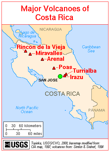
I remember memorizing the locations of 41 volcanos in Costa Rica when I was in high school. Apparently there are more though. These are the most important ones:
I wouldn't be surprised if we hear news about the Irazu volcano soon.
Yes, this was yesterday on the 17th. Today, on the 18th, the Poás volcano showed a little bit of activity.
OVSICORI reports (google translation):
_https://www.facebook.com/OVSICORI/?fref=ts
Activity report of the Poas Volcano
Three phreatic eruptions
June 18, 2016, the update to be 10:19 a.m.
Saturday June 18, 2016 in the morning there have been three phreatic eruptions in the center of the Poas Volcano lake: 1) The first at 07:48 am; 2) The second at 07:49 am; 3) The third at 10:34 PM. Phreatic columns of ejecta over the lake (water, sediments, molten sulfur and altered rock fragments) reached about 100 meters above the lake surface. The network of seismographs OVSICORI-A which monitors seismic activity of the volcano Poas, clearly recorded three seismic signals associated with these phreatic eruptions.
Poas volcano has been showing since early April 2016 an increase in the emission of steam, gases, and magmatic heat primarily through the lake, as well as several phreatic eruptions so far of small height (less than 100 meters). As a result of increased transport of steam and gases from magmatic-hydrothermal system underlying the crater, it is the fact that the lake is milky gray, with vigorous convection, evaporation, and abundant presence of molten sulfur on its surface. The actual temperature of the acid lake is around 50 degrees Celsius.
The OVSICORI-A will be sending reports on the activity of Poas Volcano observe whenever changes or events relevant to inform the public, authorities and entities.
Video link: https://www.facebook.com/OVSICORI/videos/1025012197536038/
More information about the Poas volcano:
_https://en.wikipedia.org/wiki/Po%C3%A1s_Volcano_National_Park
Poás Volcano National Park, in Spanish Parque Nacional Volcán Poás, is a National Park in Costa Rica that covers an area of approximately 65 square kilometres (16,000 acres); the summit is 2,700 metres (8,900 ft). One of the attractive features about Poás is that you can get all the way to the edge of the crater.... The main crater is 290 metres (950 ft) deep and is quite active with frequent small geyser and lava eruptions, however the last major eruptions were during 1952-54. Two more craters make up parts of the park, the extinct Von Frantzuis crater and the Botos crater. Botos is a beautiful cold, green water crater lake with a diameter of 370 metres (1,200 ft). The Botos crater has not erupted for about 7,500 years. Well-marked trails will take you to see the two inactive craters. The park is frequently closed to visitors because of sulphuric gas emissions. Over the last decade there have been a number of indications that the volcano is slowly building up towards a new eruption.
I remember that the last time I checked the wikipedia page, it said something about being the second largest crater. That trivia was removed or maybe now the record belongs to another volcano in another country? Anyway, apparently:
_http://www.vacationscostarica.com/travel-guide/poas-volcano/
Poas Volcano has the second largest volcanic crater in the world. It measures 1.5 kilometers in diameter (0.9 miles).
I remember memorizing the locations of 41 volcanos in Costa Rica when I was in high school. Apparently there are more though. These are the most important ones:
I wouldn't be surprised if we hear news about the Irazu volcano soon.
casper
The Living Force
Iceland’s Hekla volcano “ready to blow”
http://icelandmonitor.mbl.is/news/nature_and_travel/2016/06/20/iceland_s_hekla_volcano_ready_to_blow/
"A geophysics professor from the University of Iceland has warned people not to travel up Hekla volcano in South Iceland as it could erupt at any moment.
According to Professor Páll Einarsson, pressure readings within the famous volcano are now higher than before the last two previous eruptions – meaning it could blow with little warning."
Re: Iceland’s Hekla volcano “ready to blow”
An excerpt from Wikipedia about Hekla:
from https://en.wikipedia.org/wiki/Hekla
Well, it has been dormant for more than 16 years, guess it could get catastrophic indeed...I've watched recently a tv show about it, it truly impressed me, all the landscape in the surrounding area is terrific, a sight to behold! Also, yesterday I watched a doc in Netflix called "Top ten natural disasters" (http://www.imdb.com/title/tt3465600/), and it describes the deadliest eruption in modern times (I've always thought it was Krakatoa), which also ocurred in Iceland in the 18th century:
from https://en.wikipedia.org/wiki/Laki
Apart from devastating Iceland, this eruption was said to be a cause for the famine and suffering of millions, causing social unrests and the French revolution due to the freezing temperatures that followed the eruption, according to the documentary.
For a list of the ten disasters mentioned:
http://top-natural-disasters.blogspot.com.br/
An excerpt from Wikipedia about Hekla:
The earliest recorded eruption of Hekla took place in 1104. Since then there have been between twenty and thirty considerable eruptions, with the mountain sometimes remaining active for periods of six years with little pause. Eruptions in Hekla are extremely varied and difficult to predict. Some are very short (a week to ten days) whereas others can stretch into months and years (the 1947 eruption started 29 March 1947 and ended April 1948). But there is a general correlation: the longer Hekla goes dormant, the larger and more catastrophic its opening eruption will be.[17] The most recent eruption was on 26 February 2000.
from https://en.wikipedia.org/wiki/Hekla
Well, it has been dormant for more than 16 years, guess it could get catastrophic indeed...I've watched recently a tv show about it, it truly impressed me, all the landscape in the surrounding area is terrific, a sight to behold! Also, yesterday I watched a doc in Netflix called "Top ten natural disasters" (http://www.imdb.com/title/tt3465600/), and it describes the deadliest eruption in modern times (I've always thought it was Krakatoa), which also ocurred in Iceland in the 18th century:
Laki or Lakagígar (Craters of Laki) is a volcanic fissure in the south of Iceland, not far from the canyon of Eldgjá and the small village of Kirkjubæjarklaustur. Lakagígar is the correct name, as Laki mountain itself did not erupt, as fissures opened up on each side of it. Lakagígar is part of a volcanic system centered on the volcano Grímsvötn and including the volcano Þórðarhyrna.[1][2][3] It lies between the glaciers of Mýrdalsjökull and Vatnajökull, in an area of fissures that run in a southwest to northeast direction.
The system erupted over an eight-month period between 1783 and 1784 from the Laki fissure and the adjoining volcano Grímsvötn, pouring out an estimated 14 km3 (3.4 cu mi) of basalt lava and clouds of poisonous hydrofluoric acid and sulfur dioxide compounds that killed over 50% of Iceland's livestock population, leading to a famine which then killed approximately 25% of the island's human population.[4]
The Laki eruption and its aftermath caused a drop in global temperatures, as sulfur dioxide was spewed into the Northern Hemisphere. This caused crop failures in Europe and may have caused droughts in India. The eruption has been estimated to have killed over six million people globally,[5] making it the deadliest in historical times.
from https://en.wikipedia.org/wiki/Laki
Apart from devastating Iceland, this eruption was said to be a cause for the famine and suffering of millions, causing social unrests and the French revolution due to the freezing temperatures that followed the eruption, according to the documentary.
For a list of the ten disasters mentioned:
http://top-natural-disasters.blogspot.com.br/
Re: Iceland’s Hekla volcano “ready to blow”
We should prepare ourselves accordingly.
There was that movie, The Road. You never learn what happened, but whatever it was blocked the sun. The plants died. Bad times.
Apart from devastating Iceland, this eruption was said to be a cause for the famine and suffering of millions, causing social unrests and the French revolution due to the freezing temperatures that followed the eruption, according to the documentary.
We should prepare ourselves accordingly.
There was that movie, The Road. You never learn what happened, but whatever it was blocked the sun. The plants died. Bad times.
Re: Iceland’s Hekla volcano “ready to blow”
You are right. I didn't see the movie, but read the book. A terrifying experience for both father and son. Very interesting that you mentioned it, thinking about a vulcan.
Yupo said:Apart from devastating Iceland, this eruption was said to be a cause for the famine and suffering of millions, causing social unrests and the French revolution due to the freezing temperatures that followed the eruption, according to the documentary.
We should prepare ourselves accordingly.
There was that movie, The Road. You never learn what happened, but whatever it was blocked the sun. The plants died. Bad times.
You are right. I didn't see the movie, but read the book. A terrifying experience for both father and son. Very interesting that you mentioned it, thinking about a vulcan.
casper
The Living Force
Re: Turrialba Volcano spews ash 1 km high
New eruptions at Costa Rica's Turrialba and Guatemala's Fuego
"A new eruption of Costa Rica's Turrialba volcano took place at 03:37 UTC on June 25 (22:15 on June 24, local time). Dense fog is preventing estimation of volcanic cloud height. At the same time, volcanic ash produced by the fresh eruption of Guatemala's Fuego volcano is reaching 4.9 km (16 000 feet) above sea level."
http://thewatchers.adorraeli.com/2016/06/25/new-eruptions-at-costa-rica-turrialba-and-guatemala-fuego-volcano/
Re: More volcanic eruptions
Геологи предупреждают о неминуемом взрыве вулкана Павлова на Аляске
РИА Новости http://ria.ru/science/20160705/1459075550.html#ixzz4DYIayDj6
МОСКВА, 5 июл – РИА Новости. Вулкан Павлова, один из самых активных вулканов Аляски, должен взорваться и начать новое извержение в ближайшее время, предупреждают геологи из вулканической обсерватории Аляски.
Как сообщают ученые, сразу два вулкана Аляски – вулкан Павлова и вулкан Кливленд, расположенные на западной оконечности полуострова Аляска, сегодня проявляют признаки активности, свидетельствующие о том, что они могут проснуться в ближайшее время.
По словам специалистов обсерватории, в последние дни спутники зафиксировали рост температур в районе и того и другого вулкана, свидетельствующие о накоплении расплавленных пород и газа их магматических камерах, а наземные станции слежения зафиксировали вчера ночью слабые толчки и другие признаки сейсмической активности в окрестностях вулкана Павлова.
Данный вулкан является одним из самых беспокойных очагов вулканизма на Земле – за минувший год он уже извергался два раза, в марте и в мае, и прогнозируемое извержение, по мнению сейсмологов, является "неминуемым". Даже если оно не произойдет на этой неделе, то оно должно случиться до конца этого года.
За последние 40 лет вулкан Павлова уже успел совершить более 40 извержений, большая часть которых началась внезапно – в среднем, у ученых было не более получаса перед тем, как начиналось излияние магмы. Мартовское извержение Павлова привело к выбросу значительных масс пепла в атмосферу, через облако которых пролетел пассажирский самолет, что, к счастью, не привело к фатальным последствиям.
Сейчас и вулкан Павлова, и вулкан Кливленд были переведены в "желтую" категорию опасности – по текущим прогнозам, если извержение состоится, выбросы пепла будут направлены в сторону Берингова моря и российской Чукотки и Камчатки. Весь пепел, как показывают карты извержения, должен будет утонуть в море и не причинит вреда людям или технике.
Translation
Geologists warn about the imminent explosion of the volcano Pavlov in Alaska
MOSCOW, 5 Jul – RIA Novosti. The Pavlov volcano, one of the most active volcanoes of Alaska, to explode and to start a new eruption in the near future, warn geologists from the volcano Observatory in Alaska.
According to scientists, two volcano Alaska volcano Pavlov and Cleveland volcano, located on the Western tip of the Peninsula of Alaska, are showing signs of activity showing that they can Wake up soon.
According to experts of the Observatory, in recent days, the satellites recorded a temperature increase in the area of both of the volcano, indicating the accumulation of molten rock and gas in their magma chambers, and ground tracking stations recorded last night a tremor, and other signs of seismic activity in the vicinity of the volcano Pavlov.
This volcano is one of the most turbulent hotbeds of volcanic activity on Earth over the past year, he already has erupted twice, in March and in may, and predicted the eruption, according to seismologists, is "inevitable". Even if it's not going to happen this week, it should happen before the end of this year.
Over the last 40 years the volcano Pavlova has already made more than 40 eruptions, most of which began suddenly – on average, scientists were no more than half an hour before he began the outpouring of magma. The March eruption of Pavlov resulted in the release of large masses of ash into the atmosphere, through the cloud which flew passenger planes, which, fortunately, has not led to fatal consequences.
Now the Pavlov volcano and Cleveland volcano were transferred to the "yellow" category of danger under the current projections, if the eruption takes place, the ash will be directed toward the Bering sea, and Russian Chukotka and Kamchatka. The whole fly ash, as shown by maps of the eruption, will have to drown in a sea and will not cause harm to people or equipment.
Re: More volcanic eruptions
Пепловый шлейф от Ключевского вулкана на Камчатке распространился на 260 км
Происшествия 6 июля, 3:43 UTC+3
Пепел отнесло в сторону от населенных пунктов
ПЕТРОПАВЛОВСК-КАМЧАТСКИЙ, 6 июля. /Корр. ТАСС Елена Верещака/. Пепловый шлейф, образовавшийся от пятикилометрового выброса из кратера Ключевского вулкана на Камчатке, отнесло на 260 км. Об этом в среду ТАСС сообщили в Камчатской группе реагирования на вулканические извержения (KVERT) Института вулканологии и сейсмологии ДВО РАН.
"Выброс пепла на Ключевском вулкане был зафиксирован сегодня в 8:25 местного времени (23:25 мск). Его высота составила около пяти километров над уровнем моря. Ветром пепел отнесло от вулкана на 260 км", - сообщил собеседник агентства.
Так как направление ветра было юго-восточным, пепел отнесло в сторону от населенных пунктов, поэтому пеплопадов не зафиксировано. С 5 июля вулкан Ключевской начал периодически выбрасывать пар и газ с содержанием пепла на высоту до восьми километров над уровнем моря. По данным ученых, активность вулкана нарастает.
Извержение Ключевского (4 750 м), который считается самым высоким действующим вулканом в Евразии, началось 3 апреля 2016 года. Вулканологи ведут за ним круглосуточное наблюдение с помощью спутников, видеокамер и сейсмостанций. Сейчас в кратере вулкана также отмечается фонтанирование раскаленной лавы, по его склону в юго-восточном направлении стекает лавовый поток.
Подробнее на ТАСС:
http://tass.ru/proisshestviya/3432581?utm_source=rnews
Translation
Ash plume from Kliuchevskoi volcano in Kamchatka has spread to 260 km
The incident, July 6, 3:43 UTC+3
Fly ash carried away from the settlements
PETROPAVLOVSK-KAMCHATSKY, July 6. /Offset. TASS Elena Vereshchak/. Ash plume is formed from the five-kilometer emission from the crater of the Kliuchevskoi volcano on the Kamchatka Peninsula, carried on 260 km On Wednesday TASS in the Kamchatka group volcanic eruption response (KVERT) Institute of Volcanology and seismology Feb RAS.
"A plume of ash on Klyuchevskoi volcano was recorded today at 8:25 local time (23:25 GMT). His height was about five kilometers above sea level. The wind carried the ashes from the volcano of 260 km," - said the Agency interlocutor.
As the wind direction was South-East, fly ash carried away from the settlements, so pelopidas not fixed. From 5 July the volcano Klyuchevskoy has started to occasionally throw steam and gas with a content of ash up to eight kilometers above sea level. According to scientists, the volcano's activity increases.
The eruption of Klyuchevskaya (4750 m), which is considered the highest active volcano in Eurasia, started on April 3, 2016. Volcanologists lead him round the clock from satellites, video cameras and seismic stations. Now in the crater of the volcano is also seeing a gush of molten lava, its slope in a South-easterly direction flowing lava flow.
Read more on TASS:
http://tass.ru/proisshestviya/3432581?utm_source=rnews
Re: More volcanic eruptions
Lava In Hawaii Volcanoes National Park (July 3, 2016)
https://www.youtube.com/watch?v=eIv4wEe5e-Y
Lava 1 Mile From The Ocean In Hawaii (July 5, 2016)
https://www.youtube.com/watch?v=zp0RikMp14M


(July 3, 2016) Poliahu vs Pele
Hula /ˈhuːlə/
https://en.wikipedia.org/wiki/Hula
Lava In Hawaii Volcanoes National Park (July 3, 2016)
https://www.youtube.com/watch?v=eIv4wEe5e-Y
Lava 1 Mile From The Ocean In Hawaii (July 5, 2016)
https://www.youtube.com/watch?v=zp0RikMp14M
(July 3, 2016) Poliahu vs Pele
Hula /ˈhuːlə/
https://en.wikipedia.org/wiki/Hula
angelburst29
The Living Force
Re: More volcanic eruptions
A new study is warning that a volcano may be awakening in Italy in the Colli Albani Volcanic District, on the outskirts of Rome.
Researchers Fear Volcano on the Outskirts of Rome is Waking Up
http://sputniknews.com/europe/20160713/1042922499/rome-volcano-warning.html
A new Geophysical Research Letters study, authored by Fabrizio Marra and others, reports that over four million people could be at risk if the Colli Albani volcano complex, bordering the Rome metropolitan area, goes into a full-scale eruption.
The Alban Hills, or Colli Albani as it is called locally, was particularly active between 608,000-351,000 years ago, when it produced massive eruptions of ash totaling some 67 cubic miles, Wired reported.
“This change in behavior is good news for Rome, because the Colli Albani appears to be more regular in the spacing of its eruptions than most volcanoes. In their new study, Marra and team identify dormancy and recurrence intervals for the Colli Albani that, since 608,000 years ago, have varied from 29,000±2,000 to 57,000±4,000 years, averaging 41,000±2,000 years between eruptions and 38,000±2,000 years between periods of renewed activity,” Wired detailed.
Researchers propose that, as it has been roughly 36,000 years since the most recent eruptions, and that the volcanos have been remarkably consistent in their patterns, they may be due for a period of increased activity. The revelations are troubling, as the area is a mere 16 miles from the center of Rome.
“Rome doesn’t have to harbor the same apprehension that Naples must have for the Campi Flegrei and Vesuvius. However, this would be an excellent time to start planning, in case the Colli Albani does decide it is time to wake back up,” Wired suggested.
Re: Kamchatka's volcanoes activity
Kamchatka volcano spews ash to height of 6 km
http://tass.ru/en/society/888894
Kamchatka volcano spews ash to height of 6 km
http://tass.ru/en/society/888894
The eruptions of the Klyuchevskoy volcano (4,750 m) started in April 2016
PETROPAVLOVSK-KAMCHATSKY, July 18 /TASS/. The Klyuchevskoy volcano in Russia’s Far Eastern Kamchatka Peninsula sent ash to the height of 6 kilometers above the sea level on Monday, a representative with the Kamchatka affiliate of the Geophysical Service of the Russian Academy of Sciences told TASS.
"The height of an ash cloud sent by the Klyuchevskoy volcano reached the height of 6 km above the sea level. The plume spread across 30 km to the south-east," the official said.
There are no settlements on the way of the ash cloud.
Earlier the local department of the Emergency Situations Ministry sent a warning to tourist companies recommending them to change the routes of tourists due to a threat of an ash shower.
There have been eruptions of the Klyuchevskoy volcano (4,750 m) since April 2016. Periodically ash clouds form on the volcano and lava flow occurred in the crater. The south-eastern slope of the volcano has a breakthrough allowing three lava flows.
casper
The Living Force
Re: Mount Etna Erupts
Quote:
"Weak strombolian activity continues inside the Voragine summit crater, which produces a tall steam column currently drifting into southerly directions when we observed it this morning during a helicopter overflight as part of a tour on Etna.
Tremor remains currently at low levels (but this can change quickly)."
https://www.volcanodiscovery.com/etna/current-activity.html
Laura said:Session Date: July 16th 2016
(L) Well, maybe the atmospheric charge opened a portal and part of it went into another dimension! Did this have anything to do with any volcanic or planetary activity? Like any electrical connection?
A: Aetna.
Re: Kamchatka's volcanoes activity
Klyuchevskoy volcano in Russia’s Far East sends ash seven kilometers high
http://tass.ru/en/society/893440
Klyuchevskoy volcano in Russia's Far East spews ash cloud up to 7.5 km
https://www.sott.net/article/324124-Klyuchevskoy-volcano-in-Russias-Far-East-spews-ash-cloud-up-to-7-5-km
Klyuchevskoy volcano in Russia’s Far East sends ash seven kilometers high
http://tass.ru/en/society/893440
An ‘orange’ aviation alert code has been assigned to the volcano, second after the highest - red code, warning about the hazard eruptions may pose to aircraft flying on local and international routes
PETROPAVLOVSK-KAMCHATSKY, August 10. /TASS/. Klyuchevskoy volcano on the Kamchatka Peninsula in the Russian Far East has spewed ash up to seven kilometers into the sky, the Kamchatka Volcanic Response Team (KVERT) told Tass on Wednesday.
"The volcano continues erupting. The ash plume has spread 264 kilometers east and southeast of the volcano," its source said.
An ‘orange’ aviation alert code has been assigned to the volcano, second after the highest - red code, warning about the hazard eruptions may pose to aircraft flying on local and international routes.
No ash fall has been registered in settlements of the region, the Kamchatka department of the Russian Ministry for Emergency Situations reports.
The Klyuchevskoy, also known as the Klyuchevskaya Sopka, is located 360 km to the north-west of the capital of the Kamchatka Krai, Petropavlovsk-Kamchatsky. The nearest town, Klyuchi, is separated from it by a distance of 30 km and is home to about 5,000 people at present.
The volcano, which is believed to be about 7,000 years old, has the height of 4,750 meters above the sea level. Apart from being the largest active volcano in Eurasia, it is also the highest mountain in Russia outside the Caucasus.
The volcano started spewing ash in early April. Scientists say the current volcanic activity is moderate.
All in all, the Kamchatka peninsula has 29 active volcanoes.
Re: More volcanic eruptions
Iceland Sounds Alarm After Largest Volcano Rocked By Big Earthquake Cluster
http://www.zerohedge.com/news/2016-08-29/iceland-sounds-alarm-after-largest-volcano-rocked-large-earthquakes
Six years after the eruption of Iceland's Eyjafjallajokull volcano in 2010 caused the cancellation of more than 100,000 flights across Europe on concern that glass-like particles formed from lava might melt in aircraft engines and clog turbines, Iceland met office raised the alarm after its largest volcano was hit by the biggest tremors since 1977. Katla, named after an evil troll, is in southern Iceland about 140 kilometers (87 miles) from the capital, Reykjavik.
Two quakes larger than 4 in magnitude early Monday rocked the crater of Katla, the country’s Met Office said in a statement. That was followed by at least 10 more tremors at the volcano, which rises 1,450 meters (4,757 feet) into the air on the North Atlantic island’s southern coast.
The good news is that the Icelandic Meteorological Office is reporting that so far no tremor is currently recorded currently at Katla, which suggests that at least for the moment, no magma is making its way to the surface. Icelandic officials have not changed the alert status for Katla from normal at this point.
As Bloomberg notes, there were no immediate reports of casualties or damages to property. From the statement:
This night on 29 August at 01:41 an earthquake swarm started within the Katla caldera. Two earthquakes were over M4. The largest earthquake occurred at 01:47:02 M4.5 and another one 20 seconds later, M4.6. The largest earthquakes were felt in the area. About 20 aftershocks have been recorded. No tremor has been seen. About 40 earthquakes have been detected within the Katla caldera from midnight. Most of them occurred before 3 AM. The largest earthquke since then had a magnitude M3.3 at 15:12.
Historically, Eyjafjallajokull has been known to erupt one to two years prior to Katla. Katla last erupted in 1955 and 1999. Neither of those were large enough to break the ice covering its 10 kilometer-wide (6 mile) caldera. Its last major eruption was back in 1918, when it spewed ash for more than five weeks.
According to Wired, two big hazards exist at Katla right now. One is that the volcano might have its first eruption this century. That lack of harmonic tremor means that the likelihood of an imminent eruption is low. The other hazard might be a jökulhlaup, or glacial outburst flood. Melting from the summer within the Myrdalsjokull icecap and that meltwater can accumulate until it spills over as a flood of water, ice, and debris. These have occurred often and do not need to be associated with any volcanic activity.
Cited by ABC, Gunnar Gudmundsson, a geophysicist, said authorities are monitoring the situation at the volcano in southern Iceland and described it as "a little bit unusual." The quakes measured magnitude 4.2 and magnitude 4.5 and were followed by some 20 aftershocks.
"People have been waiting for an eruption for 50 years," Gudmundsson said of Katla. "But there is no sign of an eruption." Still, Katla does have a history of large, explosive eruptions, which means it makes people nervous. Keeping an eye on any restlessness at the behemoth is vital for both the people of Iceland and for air travel across the North Atlantic.
Since this is eerily similar to the current global monetary situation, one hopes that Gudmundsson's soothing words are as applicable to the financial situation around the globe as it is to Iceland's largest volcano.
Trending content
-

-

-
Thread 'Coronavirus Pandemic: Apocalypse Now! Or exaggerated scare story?'
- wanderingthomas
Replies: 30K -