Volcanoes Erupting All Over

Since New Years Day Mount St. Helens has experienced 40 earthquakes within its vicinity as aftershocks continue every few hours.

Mount St. Helens Is Rumbling Again With 40 Earthquakes Since New Years Day Jan 3, 2018
https://www.forbes.com/sites/trevornace/2018/01/03/mount-st-helens-is-rumbling-again-with-40-earthquakes-since-new-years-day/#5dfb2967370b

The most powerful earthquake was a magnitude 3.9 that occurred around midnight west coast time about 5 miles from Mount St. Helens and 23 miles from the town of Morton.

The 3.9 magnitude earthquake was felt in Portland but there were no reported injuries or damage. Since that earthquake there have been 16 more earthquakes, averaging about every half hour with magnitudes from 0.6 to 2.6. The USGS reports that the M3.9 earthquake to the northeast of Mount St. Helens is aligned with regional stress as opposed to the localized Mount St. Helen's stress axis, thus, they do believe this earthquake is related to the nearby volcano.

It is common to experience swarms of earthquakes at Mount St. Helens. The recent earthquakes appear to be both from regional stress (i.e. not related to the volcano) and from the volcano itself. In both cases, this is not a sign of an impending eruption, the earthquakes are a result of an active volcanic system and movement along regional stress fields.

Mount St. Helens is most commonly known for its major eruption in 1980, the deadliest and most economically damaging volcanic event in the history of the United States. The stratovolcano is situated just 96 miles from Seattle and 50 miles from Portland, making an eruption especially dangerous.

While Mount St. Helens hasn't had a large eruption for the past almost 38 years (there have been smaller eruptions as recently as 10 years ago) it is still considered an active stratovolcano by geologists. In fact, Mount St. Helens is considered a relatively young volcano, forming in the past 40,000 years and has been the most active volcano in the Cascade Range within the past 10,000 years.

This mountain range, along with Mount St. Helens, will continue to experience active volcanism and deadly eruptions as long as the Juan de Fuca Plate is subducting underneath the North American Plate. The dense, relatively thin, and low lying Juan de Fuca Plate is being pushed against and under the thicker and less dense North American Plate. This is due to the continuous spreading and opening of the Pacific Ocean, which has resulted in the Pacific Ring of Fire.

While the recent earthquakes may make residents nearby Mount St. Helens uneasy, there is no immediate danger of an eruption. However, this is another sign of why we need constant volcano and earthquake monitoring.

With modern monitoring systems and subsurface modeling, geologists and geophysicists are able to build a 3-dimensional picture of volcanoes such as Mount St. Helens. The constant input of data, from seismic activity to precise topographical changes allows better prediction of a future event. While we can't be certain, chances are the next time Mount St. Helen erupts, we will be significantly better prepared.
 
Tsunami, Landslides Feared After First-Time Eruption of Papua New Guinea Volcano 07.01.2018
https://sputniknews.com/asia/201801071060570752-papua-new-guinea-volcano/

Between 500 and 600 residents of the island of Kadovar, just off the coast of Papua New Guinea's main island, have been evacuated after a volcano long believed dormant erupted, spewing a massive plum of ash some 2,133 meters into the air.

Officials from the Darwin Volcanic Ash Advisory Center confirmed that the 500 meter (1,640 feet) tall volcano erupted Friday. "Since then, it's been emitting a continuous plume out to the west-northwest," center forecaster Chris Kearney said.

The eruption was still going as of Sunday morning, and could turn explosive, leading to a risk of tsunamis and landslides, according to observers.
For the moment, the 2 km-tall plume of ash is not a hazard to local aviation, but a change in wind direction could cause problems at Wewak Airport, located on the northern coast of Papua New Guinea's main island. Local media reported that over half of Kadovar has now been "covered in volcanic products." Shipping and boat operators have been advised to avoid the island.

US-based charity organization Samaritan Aviation, which flies seaplanes to remote areas across Papua New Guinea, reported on its Facebook page that
all the island's residents have been safely evacuated, and no loss of life was reported.

The Kadovar volcano has been dormant for centuries, although Kearney said that it had shown some seismic activity in 2015. "It was rumbling a bit, but it didn't erupt at the time, and that's the only activity in its recorded history apart from the recent eruption," the expert said.

Before that, the volcano may have been one of two "burning islands" referenced by English explorer and pirate William Dampier in his journals. Dampier had recorded the volcanoes in the Pacific Ocean during his search for Terra Australis, the southern continent once believed to be a myth, in the 17th-century.
 
Mount Mayon, the most active volcano in The Philippines, lurched back into action on Monday as lava slowly rose to the lip of the crater, prompting officials to order the evacuation of thousands.

Mass Evacuations in Philippines as Volcano Set to Burst
https://sputniknews.com/asia/201801161060776782-Philippines-volcano-set-to-erupt/

Located in the Albay province in the northeastern region of the island archipelago, a "hazardous eruption" warning has been issued by the Philippine Institute of Volcanology and Seismology due to overnight movements of the volcano, indicating the possibility of a violent eruption within days or even hours, according to reports.

According to local news, three steam-explosions have been recorded since Saturday, spewing ash onto villages clustered around the 8,070-foot volcano. The explosions are expected to have breached a solidified lava cap, indicating the potential for dangerous pyroclastic lava flows down the mountain side.

"Lava has flowed out of the volcano's crater already but it's just starting," stated volcanology institute head Renato Solidum, cited by Abcnews.go.com.

"It's a non-explosive eruption," Solidum detailed, adding, " "We have to verify tomorrow if it will flow continuously," cited by The Associated Press.

An estimated 1,000 families have been evacuated to emergency facilities by Filipino disaster-response teams after the volcano began spewing steam and ash on Saturday, according to reports.

Popular with tourists due to its near-perfect cone, Mount Mayon — about 210 miles southeast of capital city Manila — has erupted some 50 times over the last half millennia, often with extreme violence.

More recently, the volcano erupted without warning in May 2013, and three German hikers were among five tourists killed by hot ash and other ejecta.
 
The Philippines raised the alert level at its Mayon volcano on Monday after a loud explosion in the wake of increased activity made a hazardous eruption likelier, prompting authorities to close all schools and urge residents to stay indoors.

Philippines raises Mayon volcano alert as hazardous eruption imminent Monday 22 January 2018
http://www.arabnews.com/node/1230856/world

Mayon, the country’s most active volcano, has been spewing ash, lava, and pyroclastic material since January 13, displacing close to 40,000 residents in the central province of Albay.

The Philippine Institute of Volcanology and Seismology (Phivolcs) raised its alert on Mayon to level 4, signifying a hazardous eruption is imminent, from level 3, which warns that such an eruption could be “weeks or even days” away.

“We strongly advise all people, both residents and tourists, to avoid the danger zone, and airlines to avoid flying near the volcano summit,” agency chief Renato Solidum told a news conference.

The danger zone around the 2,462-meter volcano has been expanded to a radius of 8 kilometers, he added.

Solidum said the agency had recorded increased seismic activity and “lava fountaining and a summit explosion” from Sunday night, indicating more explosions ahead, including a hazardous eruption. A level 5 alert signifies a hazardous eruption is underway.

Albay province has run out of emergency funds and more people would be evacuated once government financial help arrived, said provincial governor Al Francis Bichara.

He ordered schools to suspend classes, amid ash fall warnings following the explosion at the volcano.

“In some areas...it’s already zero visibility, especially along the foot of the volcano,” he told CNN Philippines, adding that strong winds could carry ash to distant towns.

“(People) have to stay home and if they intend to get out of their houses, they have to wear masks,” Bichara said.
 
Sounds like a big one might be coming!!! That will certainly cool things down a bit more.
 
Mount Kusatsu-Shirane in the town of Kusatsu, Gunma Prefecture, erupted Tuesday morning, apparently triggering an avalanche and injuring at least 10 people, the Meteorological Agency said.

At least 10 injured after Gunma’s Mount Kusatsu-Shirane erupts Jan 23, 2018
https://www.japantimes.co.jp/news/2018/01/23/national/mount-shirane-gunma-prefecture-may-erupted-caused-avalanche-japans-national-weather-agency-reports/#.WmbSPP6WwdU

The mountain spewed black smoke after the eruption, which occurred at 9:59 a.m., according to the agency and the Kusatsu local government. The agency said it had detected a small volcanic tremor moments ahead of the eruption.

It warned of possible falling rocks within a 2-km radius of the mountain due to volcanic activity and raised the volcanic warning level from 1 to 3 on a scale of 5.

Level 3 bans visitors from entering the mountain and areas where it is deemed dangerous. It also urges the elderly, children and others in need of aid during evacuations to begin preparations to leave the area.

A local fire department official said four people were thought to have been carried away by the avalanche, one of whom was buried.

The roof of a rest house at a ski resort in the area was also damaged by falling rocks, according to the official. About 80 skiers had been taking shelter there. A window on a cable car at the resort was also shattered, though the cause was not known. It was unclear if any of the skiers were among the injured.

Elsewhere, six Ground Self-Defense Force members who had been training nearby were injured in the avalanche, according to the GSDF.

Gunma Gov. Masaaki Osawa later requested the SDF to be dispatched to assist in rescue operations. In Tokyo, the central government set up a liaison office at the Prime Minister’s Office.

Mount Kusatsu-Shirane, at a height of 2,160 meters, is located near the border of Gunma and Nagano prefectures and is one of 50 volcanic mountains continuously monitored by the Meteorological Agency.
 
A volcano eruption near a popular Japanese ski resort sparked an avalanche that injured at least 16 people Tuesday, officials said.

Volcano eruption sparks avalanche at Japan ski resort Tuesday 23 January 2018 (Video)
http://www.arabnews.com/node/1231436/world
https://www.youtube.com/watch?v=esyV-b7rE1w (0:30 min.)

Japan’s Meteorological Agency urged nearby residents to stay away from Mt. Kusatsu Shirane after it detected what it said was “slight volcanic activity.”

“Today an eruption occurred” at the mountain, agency official Makoto Saito told a news conference. He warned that the volcano could still spew more rocks and ash, and said there was a risk of further avalanches.

A local fire department official told AFP that 10 people had been injured in the incident. “Five of them were seriously injured. We began sending the injured to a hospital,” he said. Among the injured were four people hurt by shattered glass while on a ropeway gondola at a ski resort in Gunma, northwest of Tokyo.

The official said an earlier report that one person was missing was not accurate. The defense ministry said six infantry personnel who had been training on the mountain were also hit by the avalanche but had been rescued. “They are injured but their injuries are not life-threatening,” a ministry spokesman said.

Footage broadcast on Japanese television showed thick black smoke interspersed with falling rocks sliding down the snow-covered side of the volcano toward a ski slope. The falling rocks kicked clouds of snow into the air and they made impact. “Black smoke rose from the top of the mountain and we were told to evacuate inside 30 minutes later,” a man who was at the ski resort told public broadcaster NHK. “About 100 people have evacuated,” he said.


LEGAZPI, Philippines: Lava fountaining regularly from the Philippines’ most active volcano has flowed up to 3 kilometers from the crater in a dazzling but increasingly dangerous eruption.

Philippines’ Mayon volcano spreads lava almost 3 kilometers from crater Wednesday 24 January 2018
http://www.arabnews.com/node/1232026/world

Mount Mayon has spewed lava up to 600 meters high at times Tuesday and early Wednesday and its ash plumes stretched up to 5 kilometers above the crater. Lava flows in two gullies had advanced down the volcano’s slopes more than a kilometer and pyroclastic flows — superheated gas and volcanic debris — had reached 5 kilometers from the crater in one area, the Philippine Institute of Volcanology and Seismology said Wednesday morning.

An explosion from the crater at nightfall Tuesday was capped by one of the most massive lava displays since Mayon started erupting more than a week ago. Authorities on Monday expanded the no-go zone to 8 kilometers from the crater and have warned a violent eruption may occur in hours or days, characterized by more rumblings and pyroclastic flows that will vaporize everything in their path.

At least 56,217 people were taking shelter in 46 evacuation camps Tuesday and army troops and police were helping others leave the danger zone.
 
Volcano Ebeko is a natural sight featuring quite often in news reports, as it frequently stages spectacular "ash" shows for those living on Russia’s Sakhalin island as well as guests to the picturesque Far Eastern region.

Russian Pompeii: Volcano on Kurils Sends Two-Kilometer Ash Plume Into Air (Video)
https://sputniknews.com/news/201802241061963022-russia-pompeii-volcano/
https://www.youtube.com/watch?v=rFSjC99JBQ8 (1:08 min.)

On Saturday, the volcano, which lies on Paramushir island on the Northern Kurils sent up into the air an ash plume of about 2 kilometers above the sea level. "The ash cloud has moved east of the volcano," a report by a local volcano eruption response unit [KVERT] of Institute of Volcanology and Seismology, the Russian Academy of Sciences, reads.

The current activity of the volcano may impact low flights and operations of Severo-Kurilsk airport, KVERT group has noted.

Wind gusts have also reportedly brought volcano ash to the small town of Severo-Kurilsk, Russian media wrote.

Sporadic ash emissions were reported all through the year of 2017, with dense ash plumes rising several hundred meters, which was easily observed from Severo-Kurilsk. The activity reportedly continued with a moderate emission of steam and gas, triggered by ground waters, which get heated by an underlying magma. The latter doesn’t usually reach the surface, though.

The Kuril islands in Russia's breathtakingly beautiful Sakhalin region, are a volcanic archipelago that occupies a vast land of roughly 1,300 kilometers northeast of Japan’s Hokkaido to Russia’s Kamchatka, drawing a line between the Sea of Okhotsk and the north Pacific Ocean.
 
19.04.2018 - Computer Simulations shed light on Yellowstone's Massive, Mysterious Volcano
Computer Simulations Shed Light on Yellowstone's Massive, Mysterious Volcano

A computer model of the US’ Yellowstone National Park supervolcano, put together by researchers from the University of Oregon, has revealed new details about the hot spot’s history and inner workings.

Employing a sophisticated technique that uses established data to run scenarios and predict new outcomes, University of Oregon geologist Ilya Bindeman and his team created a computer model that confirmed recent discoveries and uncovered new details about the Yellowstone supervolcano that last erupted about 630,000 years ago.

The simulations confirmed that two giant magma reservoirs, formed over the course of 7 million years, are boiling underneath Yellowstone, one located 4 to 14 kilometers beneath the surface, and the other at a depth of 20 to 45 kilometers.

Based on the researchers' computer model, these two areas could be separated by a cooler magma shelf about 10 to 15 kilometers thick. This unmelted "mid-crustal sill," or "crustal transition zone," is where cold rocks meet with the hot magma. As the cold and hot rocks intermingle with each other and temperature transitions take place, the magma solidifies into clumps on the sill.

"This work appears to validate initial assumptions and gives us more information about Yellowstone's magma locations," Bindeman said in the study, published this week in Geophysical Research Letters.

The supercomputer's 3-D modelling also showed that the monstrous supervolcano could have been pushed out of the Pacific Ocean to its present location by powerful tectonic movements. The new theory contradicts the well-accepted hypothesis that Yellowstone rose up from deep in the Earth's mantle.


While the new study doesn't offer any predictions for the supervolcano's next eruption, the information is a step toward a more comprehensive understanding of the beast and can be used for further research.
 
Apr 28, 2018

Published on Apr 26, 2018

Published on Apr 19, 2018 Japanese News

Published on Apr 2, 2018
Landsat 8 shows the effects after Volcan de Fuego erupted (January 8, 2018), in Guatemala. At the USGS EROS Center, we study land change, operate the Landsat satellites, and maintain the longest, continuously acquired collection of images of the Earth's land surface.
 
Last edited:
Lava outbreak triggers evacuations in Hawaii amid fears of imminent eruption (VIDEOS)
Published time: 4 May, 2018 03:28
People in the vicinity of the Big Island’s Kilauea crater are being evacuated as lava threatens residential areas, after the most active volcano in Hawaii was disturbed by hundreds of small quakes and started shooting out ash.

The lava outbreak has reached the Leilani Estates on the Hawaii island, forcing the County Civil Defense to issue evacuation orders to some 10,000 residents of Puna community into emergency shelter set up by the American Red Cross.

Residents from Luana Street to the end of Leilani Estates are being asked to vacate their homes, Civil Defense confirmed, according to Khon Channel 2. In addition, areas bordering the East Rift Zone, from Puu Oo crater down to Kapoho, also face a high risk, and are urged to prepare an emergency plan.


River of lava cuts through Leilani Estates; evacuations ordered
Friday, May 4th 2018, 6:36 am CEDT Video's 03: 31 Tweets Pic's
PUNA, BIG ISLAND (HawaiiNewsNow) -
Mandatory evacuations are underway in Leilani Estates, where "fountains" of lava are shooting in the air, residents say

Authorities are responding to a lava outbreak in Leilani Estates, where officers are going door-to-door to tell residents to evacuate.

Hawaii County Civil Defense is urging residents in the Puna community, home to about 10,000 residents, to get out now. The American Red Cross of Hawaii has opened an emergency shelter at Pahoa Community Center.

Residents and social media posts show lava spewing from cracks in roadways. Resident Ikaika Marzo said he could see "fountains" of lava in the community.

The lava outbreak was first reported about 4:30 p.m., some six hours after a 5.0-magnitude earthquake shook the Big Island Thursday morning. That quake came after after hundreds of small tremors rattled the island since last week.

The Hawaiian Volcano Observatory said the larger quake Thursday caused rockfalls and possibly an additional collapse into the Puu O'o crater, but no other significant changes at the volcano. The plume dissipated as it drifted southwest, dropping ash on some nearby communities.

The quake happened around 10:30 a.m., and was centered in the south flank of Kilauea volcano at a depth of 6.9 kilometers, the USGS said. It was originally reported as a 4.6-magnitude tremor, but its strength was later increased.

Residents from Puna to Hilo said they felt the temblor, the biggest in recent days to hit Hawaii Island, which has been rattled with hundreds of small earthquakes since last week. The larger quake was followed up by several smaller tremors ranging in magnitude from 2.5 to 2.8.

Earlier Thursday, seismic activity had flagged — a good sign — but officials continued to stress that residents along Kilauea's east rift zone should continue to prepare for a possible eruption.

The first signs of trouble in Leilani Estates came about 4:30 p.m. Thursday, when residents reported plumes of smoke spewing from cracks in the road.

On Wednesday, cracks were also reported on the road in Leilani Estates, but officials reported they did not pose a lava threat.

Still, the cracks added to residents' anxieties as the quakes didn't let up.

"Last night, we started having them ... about five a minute. It was like that just about all night long," said Chris Burmeister, who lives in Leilani Estates. "It'll rumble for a little bit. Rumble for a little bit. And then every now and then, you'll get just a heavy jolt."

According to the U.S. Geological Survey, there were nearly 70 earthquakes of magnitude 2.5 or stronger from Tuesday to Wednesday.

Officials have said it's impossible to predict where an eruption might happen, but areas that could be affected include Nanawele Estates, Leilani Estates and the coastal area of Kapoho.

Hawaii County Civil Defense has opened its Emergency Operations Center and identified shelters if evacuation orders are issued.
 
Pretty Crazy. It started on Mohala St. I used to live in Leilani on Mohala back in 2007! I have pictures of my daughter when she was 7 years old skipping down Mohala with a hand full of bamboo orchids she picked from the jungle. SOOO weird to see it exploding into a fireworks show. And to think, I considered buying property there because it is so serene and beautiful!
 
The 1955 outbreak Kilauea's newest eruption is being compared to went on for months
Video/09:33 Friday, May 4th 2018, 10:30 pm CEDT


May 4, 2018
New lava fissure on Makamae and Leilani Streets in Leilani Estates subdivision

USGS: Volcano Hazards Program HVO Kilauea
previewImage-1943.jpg

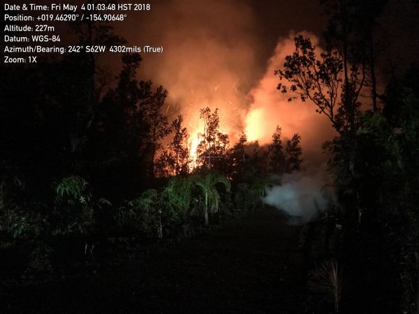
A new lava fissure commenced around 1:00 am HST on Kīlauea Volcano's lower East Rift Zone on Makamae and Leilani Streets in the Leilani Estates subdivision. Spatter was being thrown roughly 30 m (about 100 ft) high at the time of this photo. Copious amounts of sulfur dioxide gas, which should be avoided, is emitted from active fissures. The eruption is dynamic and changes could occur with little warning.

Yellowstone's Largest Geyser Erupts 3 Times, Puzzling Scientists
May 3, 20184:13 PM ET / NPR Radio / 5:40
Snip:
The world's largest active geyser has erupted three times in the past two months at Yellowstone National Park, leaving scientists puzzled by the sudden and relatively frequent explosions.

The Steamboat Geyser erupted on March 15, April 19 and April 27, marking the first time since 2003 that it has blown three times in a year, according to the U.S. Geological Survey's Yellowstone Volcano Observatory. Scientists are confused by the recent surge in activity at Yellowstone, the national park that lies on top of a giant volcanic hot spot and sprawls across Wyoming, Montana and Idaho.

Steamboat — like most other geysers — is known for sporadic eruptions, says Bob Smith, a distinguished professor at the University of Utah, who has studied the geysers at Yellowstone for 61 years. The last time Steamboat erupted was in September 2014, according to Reuters.
 
6 pm Eruption Update - 26 Homes Destroyed In Leilani Estates

STORY SUMMARY
LEILANI ESTATES, Hawaii
- Conditions permitting, Leilani Estates residents will be allowed to continue evacuation to check on their property from 7 AM to 6 PM each day until further notice, civil defense says.


Alaska Volcano Observatory - Current AVO Reports
Issued: Sunday, May 6, 2018, 12:16 PM AKDT
Location: N 52 deg 49 min W 169 deg 56 min
Elevation: 5676 ft (1730 m)
Area: Aleutians
Volcanic Activity Summary:
The last detected explosive activity at Cleveland volcano occurred May 5, 2018 UTC (May 4 local time). We have no evidence of significant eruptive activity since that time. Thus, AVO is lowering the Aviation Color Code to YELLOW and the Volcano Alert Level to ADVISORY.

Future explosive activity is likely, and explosions usually occur without warning. Explosions from Cleveland typically produce relatively small volcanic ash clouds that dissipate within hours; however, more significant ash emissions are possible.

Cleveland volcano is monitored by only two seismic stations, which restricts AVO's ability to detect precursory unrest that may lead to an explosive eruption. Rapid detection of an ash-producing eruption may be possible using a combination of seismic, infrasound, lightning, and satellite data.
YELLOW
Volcano is exhibiting signs of elevated unrest above known background level or, after a change from a higher level, volcanic activity has decreased significantly but continues to be closely monitored for possible renewed increase
Pleistocene volcanism and shifting shorelines at Lake Tahoe, California
April 18, 2018 USGS: Volcano Hazards Program California Volcano Observatory
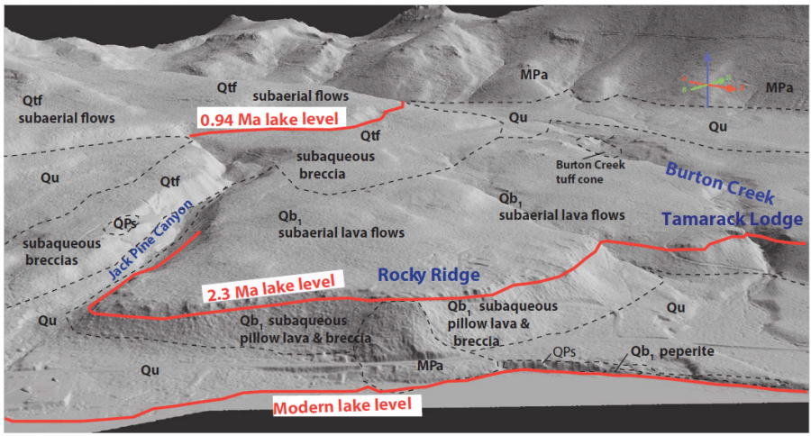
A recently-published study co-authored by two CalVO scientists brings attention to the role that lava dams played in shaping Lake Tahoe. New radiometric argon ages have revealed that between 2.3 and 0.94 million years ago, a small volcanic field in the northwestern Lake Tahoe basin produced basaltic lava flows that dammed the lake three separate times. These 'lava dams' raised the lake level level dozens to hundreds of feet and created raised shorelines. In addition, deltas of brecciated (fragmented) lava, pillow basalts, and tuff cones were formed where lava flows entered the lake - deltas and tuff cones when it reacted explosively with the water, and pillow basalts when the entry was less violent.

img5987_900w_484h.png


The repetitive timing of this volcanic activity poses some interesting questions about hazards. The Lake Tahoe area is not currently considered to be volcanically active (it must have had an eruption in the last 10,000 years to meet that criteria). However, if magma were to return to the area, future eruptions and new lava dams would pose a flooding hazard both around the Lake Tahoe basin and beyond. Lava dams are known to fail rapidly, and a dam that raised the level of the lake and then collapsed could cause serious flooding downstream along the Truckee River. For now, however, there is no danger of an eruption, and such an event might be hundreds of thousands or even millions of years in the future - or might never occur at all.

Kortemeirer, W., Calvert, A., Moore, J.G., Schweickert, R., 2018, Pleistocene volcanism and shifting shorelines at Lake Tahoe, California: Geosphere, vol. 14, no. 2, 23 p. doi:
 
Back
Top Bottom