Volcanoes Erupting All Over


https://twitter.com/bigislandnews/status/1001310071031119872
VUv8efpz

[B]Big Island Video News [/B]‏ @[B]bigislandnews 3 hours ago [/B]
VIDEO: Hawaii Eruption Update From Civil Defense 8:51 PM - 28 May 2018

Published on May 28, 2018

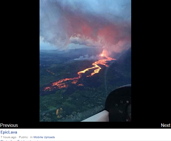
Kilauea's Halemaumau Crater grows exponentially as theory behind explosions shifts
Updated: May 28, 2018 08:12 PM HST
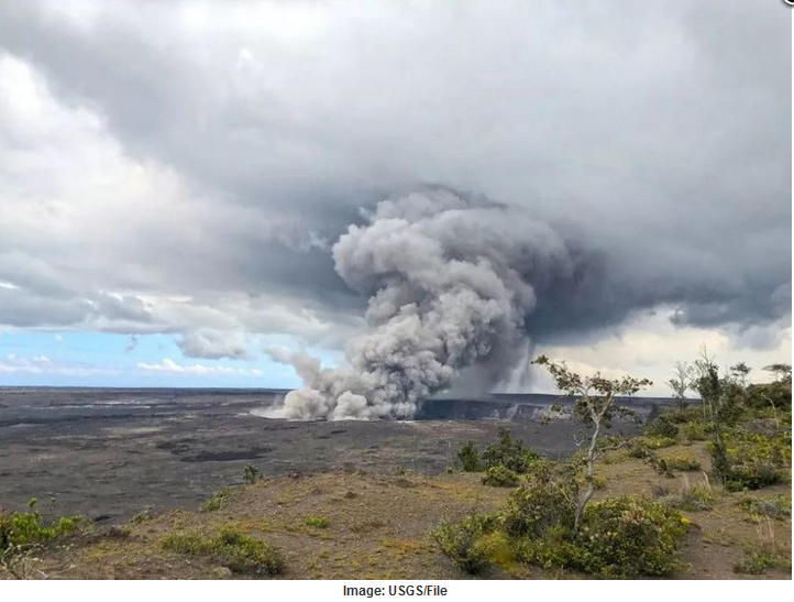
HAWAII NATIONAL PARK (KHON2) - Halemaumau Crater has grown exponentially, from 12 acres just a few weeks ago to more than 90 acres today.

U.S. Geological Survey Hawaiian Volcano Observatory geophysicist Jim Kauahikaua says a similar phenomenon occurred during the last explosive event back in 1924.

"The current Halemaumau was formed by explosions in 1924. Previous to the explosions, Halemaumau was half the diameter that it is today. We're seeing many aspects of 1924 over again, and one of them is the winding of the actual vent down to whatever is down there," he said.

Scientists say with no lava to provide resistance, along with dozens of earthquakes every day at the summit, the walls of the crater are caving in. All that rockfall is adding to what could become more projectiles flying back out of the crater in future explosions.

With more data comes an evolution of theory, including the idea that all these summit explosions could be fueled by gas, and not steam, as scientists originally thought.

"Our senior geologist, Don Swanson is looking at all that data. He's beginning to think that maybe the steam blast idea was not quite accurate, and that's causing him to look back at 1924, when they had far less instrumentation or analytical capabilities, and thinking 1924 wasn't a steam blast either, that it was the same mechanism, more like a gas pressurization, amd expansion, explosion. There are instrumental measurements that contradict that so as science goes on, we keep asking questions," Kauahikaua said.

Monday along saw two significant explosions. One at 4:35 a.m. sent ash roughly 10,000 feet above sea level, and another at 6:30 a.m. prompted ash to reach 12,000 feet above sea level.

"There's a lot of new magma left over from that lake in solid bits in the veneer of the walls and at the surface. So whatever we see coming out in the explosions now, if it has the look of fresh lava, we have not developed a test yet to figure out whether it's some older stuff that just got blown up by the convection of air or whatever is happening in there, or whether it's some evidence of molten lava that's solidified from below," Kauahikaua said.


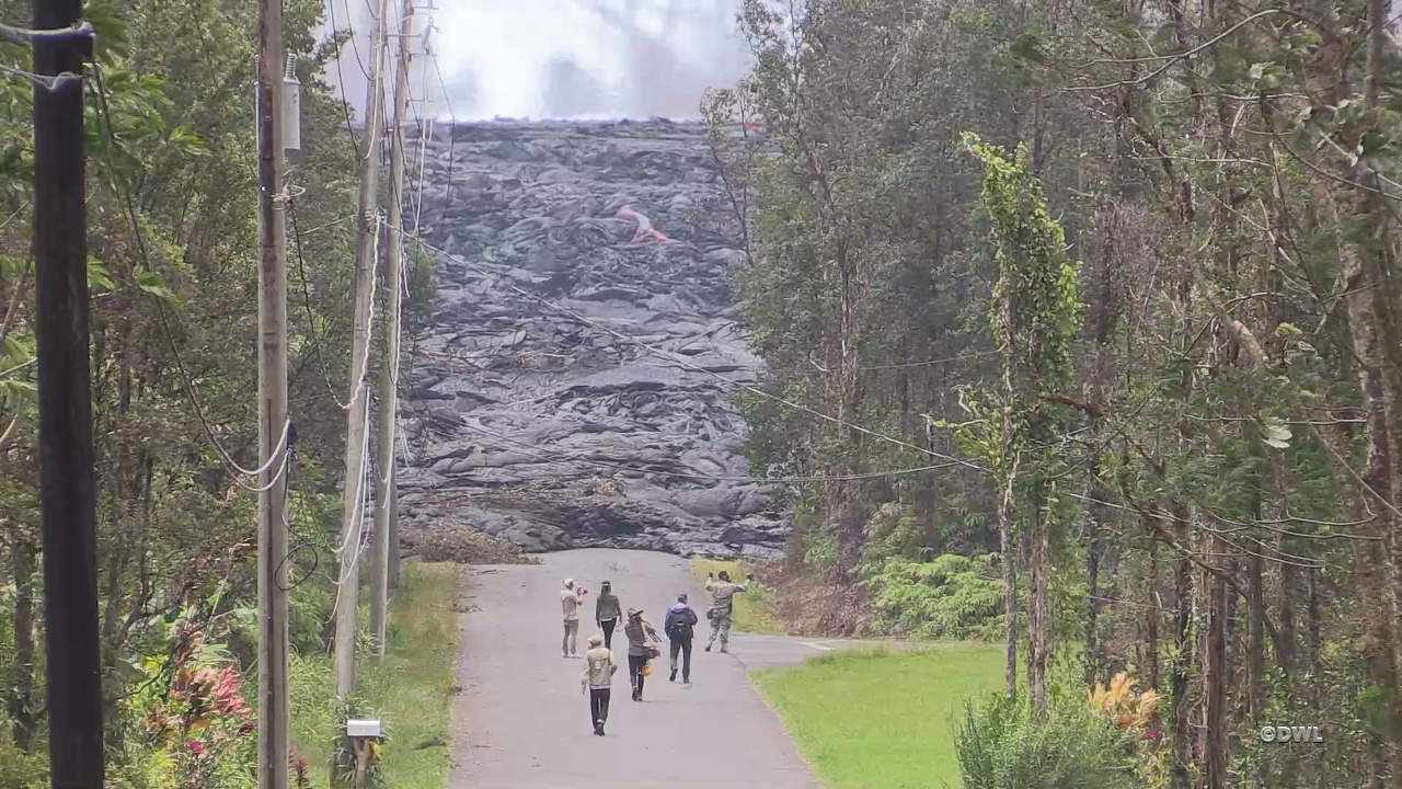
High Alert: Lava from Kilauea oozes over well at geothermal plant
US Military News TV
Published on May 28, 2018
Lava from the Kilauea volcano covered at least one well Sunday at a geothermal power plant on the Big Island, according to a Hawaii County Civil Defense report. The well was successfully plugged in anticipation of the lava flow, and a second well 100 feet away has also been secured, according to the report. The plugs protect against the release of gas that could turn toxic when mixed with lava.

The lava breached the property overnight. David Mace, a spokesman for the Federal Emergency Management Agency, said the flow started about 200 yards away from the nearest well. But he said safety precautions went into effect before the breach.

"I think it's safe to say authorities have been concerned about the flow of lava onto the plant property since the eruption started," he said.

The Hawaii Civil Defense Agency said all the wells remained "stable and secure" in a statement released Sunday night. Governor David Ige told reporters that the power plant was "sufficiently safe."

Puna Geothermal, owned by Nevada's Ormat Technologies, was shut down shortly after Kilauea began spewing lava on May 3. The plant harnesses heat and steam from the Earth's core to spin turbines to generate power. A flammable gas called pentane is used as part of the process, though officials earlier this month removed 50,000 gallons of the gas from the plant to reduce the chance of explosions. They also capped the 11 wells at the property to try to prevent a breach.

Before the lava reached the well, plant spokesman Mike Kaleikini told the news agency Hawaii News Now that there was no indication of the release of the poisonous gas hydrogen sulfide - the greatest fear should lava hit the wells.

"As long as conditions are safe, we will have personnel on site," Kaleikini said. "Primary concern is sulfur dioxide from the eruption and lava coming on site. We monitor for hydrogen sulfide and sulfur dioxide on a continuous basis.

" Steve Brantley of the Hawaiian Volcano Observatory said the flow seemed to have halted Sunday morning before it picked back up and covered the well at the plant, which lies on the southeast flank of the volcano, nestled between residential neighborhoods.

Lava-filled fissures have torn apart chunks of the southeastern side of the Big Island over the past three weeks as Kilaeau has become more active.

An active fissure in the hard-hit Leilani Estates community began belching lava at a faster rate on Sunday, forcing some residents to evacuate and leaving one man briefly trapped in his home. Hawaii News Now reported that the man was eventually guided safely off his property by emergency crews

Magnitude 4.1 earthquake reported near Volcano, NO tsunami threat
Updated: May 28, 2018 06:10 PM HST
HONOLULU (KHON2) -
The Pacific Tsunami Warning Center reports the earthquake that occurred at approximately 5:39 p.m. was NOT large enough to cause a tsunami for the Island of Hawaii.

Preliminary data from the U.S. Geological Survey indicates that the earthquake measuring a magnitude of 4.1 was centered nearly five miles south of Volcano, in the Hilina region of Kilauea.

As in all earthquakes, be aware of the possibility of aftershocks.

If the earthquake was strongly felt in your area, precautionary checks should be made for any damages; especially to utility connections of gas, water and electricity.

Leilani Estates residents told to leave in light of fast-moving flow, lava fountains
Updated: May 28, 2018 06:23 PM HST Video / 21:05
Snips:
The National Weather Service reports light easterly winds are expected to push volcanic gases westward. This includes increased ash and sulfur dioxide downwind of the Kilauea summit and fissures on East Rift Zone. Leilani Estates has high levels of vog and sulfur dioxide.
***
Active fissures are feeding a fast-moving flow that borders the Leilani Estates subdivision, claiming another 10 homes. Officials won't be able to confirm exactly how many were lost until Tuesday, when the real property and housing office reopens.
***
On Friday, officials confirmed the total number of structures destroyed by lava was 82, and 41 of them were residences. Hawaii County Civil Defense administrator Talmadge Magno says 37 additional structures have been isolated, rendered inaccessible by lava flow.
***
Hawaii County officials say 24 fissures have opened in Leilani Estates since Thursday, May 3.

Click here for an interactive map.
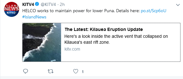
Related Story: Puna Geothermal Venture deemed stable after lava covers two wells
Related Story: People evacuated by helicopter from neighborhood isolated by fast-moving lava
Here are some tips on what to do if your catchment system is impacted by ashfall.
Related Link: University of Hawaii’s Vog Measurement and Prediction Project
Related Story: How to protect yourself from sulfur dioxide in vog, acid rain


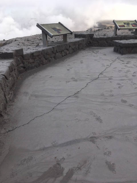
Earthquake activity and ground deformation continue and additional outbreaks in the general area of Leilani Estates are expected.
https://media.khon2.com/nxs-khontv-media-us-east-1/photo/2018/05/17/cracks_usgs 2_1526594124724.jpg_42881803_ver1.0_1526596498289.jpg_42884018_ver1.0_640_360.jpg
https://volcanoes.usgs.gov/observatories/hvo/multimedia_uploads/multimediaFile-2039.jpg


image-448.jpg

The Coast Guard is enforcing a Lava Entry Safety Zone for the navigable waters surrounding active lava flow entries extending 300 meters in all directions.
EarthQuakes.png
 
Last edited:
Pompeii Man Had a Really, Really Bad Day 2,000 Years Ago
May 29, 2018 05:24pm ET
Snip:
Archaeologists just excavated the skeleton of a decapitated man who was thought to be fleeing the catastrophic eruption of Mount Vesuvius in 79 A.D. Credit: Parco Archeologico di Pompei

High Alert: Fast-moving lava flow threatens more homes in lower Puna
May 29, 2018

Adapt 2030 Published on May 29, 2018
It seems that a continuous cloud of Sulfur Dioxide (SO2) is drifting to Asia, as long as the eruption continues the SO2 cloud will continue. Here is the question, the experts say do not worry, but what if the eruption lasts for years? The grand solar minimum is intensifying, so should the eruptions. As we saw in the Late Antique Little Ice Age 535 AD, SO2 was a main driver for respiratory problems in the N. Hemisphere. These experts by the way telling us not to worry are the same ones in the IPCC which have given us not so accurate reports on what would happen with our climate.

Published on May 29, 2018 / 1:39:41
 
comp-msa.png
WeSaCom APT-06AD, Germany
2018-05-31 09:45 #1 - Composite UTC
noaa-18-05310808-msa.jpg

F2FT, Cassis, France
--------------------------------------------------------------------------------------------------------------------------------------------------------
noaa-19-05311556-msa-precip.jpg

Moscow, Russia Image was updated 31.05.2018 at 13:58 ( 31.05.2018 11:56 UTC ) by satellite NOAA 19. Enhancement type - MSA-precip
Description of enhancement MSA-precip:
Multispectral analysis. Uses a NOAA channel 2-4 image and determines which regions are most likely to be cloud, land, or sea based on an analysis of the two images. Produces a vivid false-coloured image as a result. There are several options which affect colouring of these images in Image and Movie Options... under the Options menu. This enhancement does not use a palette nor is it temperature normalised. High cold cloud tops are coloured the same as the NO enhancement to give an approximate indication of the probability and intensity of precipitation


Residents in communities inundated with ash fear health impact
Thursday, May 31st 2018, 11:23 am CEDT Video / 02:12
8bc80ca981eb86bc047138435bf09f94.png

http://khnl.images.worldnow.com/ima...scale&width=800&lastEditedDate=20180531042157


01130cf41c6f13eee17c8eee0366037f.png

Pacific Command gets new leader — and new name
 
Ditrianum Published on Jun 1, 2018
Seismic activity in Hawaii has resumed after a dip of only 60 quakes yesterday. The Mayotte Island region is close to the antipode of Hawaii, thus seismic activity there may not be a coincidence. The Merapi volcano on Java has entered a new phase and code red has been given for aviation. Hurricane season has started with the first subtropical storm Alberta that made landfall in Florida on May 28.

TheEarthMasterPublished on Jun 2, 2018
Current World Earthquake Map https://earthquake.usgs.gov/earthquak... Recent California and Nevada Earthquakes http://scedc.caltech.edu/recent/ Current Space Weather info http://www.spaceweather.com/


7h7 hours ago
Notice from photo: 1. pad E that covered first is in same condition, mostly gone but lava stopped near the east side.
2. the sub station that got covered on may 30 (north west part) is in same condition
3. no additional wells covered since. 4. major lava river at access rd.

Guccifer4.0
cdd66b00079668c8330fa0e497948078.png

EpicLava


Sunday, June 3rd 2018, 12:55 pm CEDT
16877656_G.jpg

Ongoing eruption claims at least 87 homes
 
Last edited:

03 June 2018 - 'River of lava' flows into Guatemala village killing several people (Photos)
'River of lava' flows into Guatemala village killing several people

Lava flowing from the eruption of Guatemala’s Fuego volcano has killed several people, according to emergency workers.

At least six people were killed and another 20 injured on Sunday when Guatemala’s Fuego volcano erupted violently, spewing a stream of red hot lava and belching a thick plume of black smoke and ash high into the sky.

“It’s a river of lava that overflowed its banks and affected the Rodeo village. There are injured, burned and dead people,” Sergio Cabanas, the general secretary of Guatemala’s Conred disaster agency, said on radio.

“We are evacuating and rescuing people and have reports of 20 wounded, six dead and disappeared,” said Cabanas.

The eruption also forced the Guatemala City’s La Aurora international airport to shut down its only runway.

The runway was closed due to the presence of volcanic ash and in order to guarantee passenger and aircraft safety, Guatemala’s civil aviation authority said in a Tweet.

The active volcano is located some 25 miles (40 km) southwest of the capital Guatemala City and is close to the colonial city of Antigua, popular with tourists and known for its coffee plantations.

Workers and guests were evacuated from the La Reunion golf club near Antigua. A video circulating on social media showed a black cloud of ash rising from just beyond the golf club. The lava river was running on the other side of the volcano.

The huge plumes of smoke that could be seen from various parts of the country and the ash that rained down in four of Guatemala’s departments caused some alarm among residents.

Officials initially asked residents to remain calm.

David de Leon, spokesman for the National Disaster Prevention Authority said a change in wind was to blame for the volcanic ash falling on parts of the city.
 
Monday, June 4, 2018 - Guatemala volcanic eruption sends lava into homes, kills 25 (Video - photos)
Guatemala volcanic eruption sends lava into homes, kills 25

EL RODEO, Guatemala (AP) — A fiery volcanic eruption in south-central Guatemala sent lava flowing into rural communities, killing at least 25 as rescuers struggled to reach people where homes and roads were charred and blanketed with ash.

The death toll rose late Sunday with 18 bodies found in the community of San Miguel Los Lotes, disaster agency spokesman David de Leon said, adding to the seven victims previously confirmed elsewhere earlier in the day.

At least 20 people were injured, and authorities have said they feared the death toll could rise with an undetermined number of people unaccounted for.

The Volcan de Fuego, or "Volcano of Fire," exploded in a hail of ash and molten rock shortly before noon, blanketing nearby villages in heavy ash. Lava began flowing down the mountain's flank and across homes and roads around 4 p.m.

Eddy Sanchez, director of the country's seismology and volcanology institute, said the flows reached temperatures of about 1,300 degrees Fahrenheit (700 Celsius).

Dramatic video showed a fast-moving lahar, or flow of pyroclastic material and slurry, slamming into and partly destroying a bridge on a highway between Sacatepequez and Escuintla.

Sacatepequez television published images of a charred landscape where the lava came into contact with homes. Three bodies lay partially buried in ash-colored debris from the volcano, which lies about 27 miles (44 kilometers) west of Guatemala City.

Other videos from local media showed residents walking barefoot and covered in muddy residue.

"Not everyone was able to get out. I think they ended up buried," Consuelo Hernandez, a resident of the village of El Rodeo, told the newspaper Diario de Centroamerica.

"Where we saw the lava fall, we ran to a hillside" to escape, she added.

Homes were still burning in El Rodeo late Sunday, and a charred stench hung over the town.

Hundreds of rescue workers, including firefighters, police and soldiers, worked to help any survivors and recover any more bodies amid the still-smoking lava.

Firefighters said they had seen some people who were trapped, but roads were cut by pyroclastic flows and they had been unable to reach them.

Amid darkness and rain, the rescue effort was suspended until early Monday morning, municipal firefighters' spokesman Cecilio Chacaj said.

Among the fatalities were four people, including a disaster agency official, killed when lava set a house on fire in El Rodeo village, National Disaster Coordinator Sergio Cabanas said. Two children were burned to death as they watched the volcano's second eruption this year from a bridge, he added.

Another victim was found in the streets of El Rodeo by volunteer firefighters and died in an ambulance.

At an ad-hoc morgue in the town of Alotenango, at least three bodies lay covered with blue sheets.

Guatemala's disaster agency said 3,100 people had evacuated nearby communities, and ash fall from the eruption was affecting an area with about 1.7 million of the country's 15 million or so people. Shelters were opened for those forced to flee.

"Currently the volcano continues to erupt and there exists a high potential for (pyroclastic) avalanches of debris," the disaster agency said late Sunday via Twitter, quoting Sanchez, the director of the seismology and volcanology institute.

Guatemalan President Jimmy Morales said he would issue a declaration of a state of emergency to be approved by Congress and urged people to heed warnings from emergency officials.

Ash fell on the Guatemala City area as well as the departments of Sacatepequez, Chimaltenango and Escuintla. Streets and houses were covered in the colonial town of Antigua, a popular tourist destination.

Aviation authorities closed the capital's international airport because of the danger posed to planes by the ash.

One of Central America's most active volcanos, the conical Volcan de Fuego reaches an altitude of 12,346 feet (3,763 meters) above sea level at its peak.


34302686_1708156645888233_6919352438826729472_n.jpg

Por actividad volcánica suspenden operaciones aéreas en Aeropuerto La Aurora

Deadly 'Volcano of Fire' Erupts in Guatemala
The Volcan de Fuego, or "Volcano of Fire," erupted in southern Guatemala early Sunday morning, killing at least 25 people and displacing more than 3,000 Guatemalans. The eruption sent lava flowing into homes, covering them in ash and scorching roads. At least 20 people were ...See More
Guatemala-officials-AP_18155051547427.jpg
1 of 18


Así cubrió el cielo la impresionante erupción del Volcán de Fuego en Guatemal
This is how the impressive eruption of the Volcán de Fuego in Guatemal covered the sky
https://youtu.be/rQ0x26PT3JE?t=4s

 
On this day June 5, 2018.

Interactive map of currently active volcanoes
active-volcano-map.jpg

Worldwide Volcano News and Updates:
Volcanoes Today, 5 Jun 2018: Fuego volcano, Dukono, Kerinci, Yasur, Sabancaya, Ebeko
Tue, 5 Jun 2018, 08:00
Fuego volcano (Guatemala): update on the deadly eruption of Sun 3 June 2018
Tue, 5 Jun 2018, 07:34
Dukono volcano Volcanic Ash Advisory: CONTINUOUS EMISSION TO FL060 EST VA DTG: 05/0415Z
Tue, 5 Jun 2018, 04:15 Volcanic Ash Advisory Center Darwin (VAAC) issued the following report: ...more [read all]
Sabancaya volcano Volcanic Ash Advisory: UNABLE TO DETECT
Tue, 5 Jun 2018, 03:00

Satellite image of Sabancaya volcano on 5 Jun 2018
Volcanic Ash Advisory Center Buenos Aires (VAAC) issued the following report: ...more [read all]
Kerinci volcano Volcanic Ash Advisory: MINOR EMISSIONS TO FL140 MOV W 5KT OBS VA DTG: 05/0050Z
Tue, 5 Jun 2018, 01:00
Volcanic Ash Advisory Center Darwin (VAAC) issued the following report: ...more [read all]
Ebeko volcano Volcanic Ash Advisory: ERUPTION AT 20180604/2306Z FL100 EXTD NE REPORTED OBS VA DTG: 05/0040Z
Tue, 5 Jun 2018, 01:00
Volcanic Ash Advisory Center Tokyo (VAAC) issued the following report: ...more [read all]
Yasur volcano Volcanic Ash Advisory: INTERMITTENT LOW LEVEL ERUPTION EST VA DTG: 04/2340Z
Tue, 5 Jun 2018, 01:00
Volcanic Ash Advisory Center Wellington (VAAC) issued the following report: ...more [read all]

Jun 4, 2018


Lava flow from fissure 8 enters Kapoho Bay, breakout at intersection of Railroad Ave and Cinder Rd
Updated: Jun 04, 2018 05:53 PM HST Video 06:57

On Sunday, a magnitude-5.5 earthquake rattled the summit area at 3:50 p.m., cracking the overlook deck at Jaggar Museum. (Hawaii Volcanoes National Park/Special to West Hawaii Today)
web1_40759449930_e2e18427c5_o.jpg

Structures, roads damaged by seismic activity at Hawaii Volcanoes National Park
multimediaFile-2165.gif


Jun 5, 2018
 
Back
Top Bottom