Volcanoes Erupting All Over

I recently watched a documentary on the awakening of Vesuvius.
Some scientists predict that Vesuvius will erupt soon. In cities that are close to this volcano, the ground is registered to rise.
The case looks very interesting. Volcanic activity is slowly increasing.
The documentary also mentioned Baiae. This city was visited in the past by Caesar and Cleopatra, among others. Today it is submerged.
Are we in for another event that will go down in the pages of geological history for eternity?

2012-11-03-16-48-21.jpg

From what I understand is, that the region around Vesuvio, is calm - and has been like that for a long time.

It is the Campi Flegrei to the west, with the town of Pozzuoli at the center of a partially submerged caldera from which the former city Baiae is part of. So, that whole area is highly unsettled and has been rising something like 90 cm in recent years. I believe the area rises around 11 mm per month.

2012-06-12-20-00-30pano.jpg

When I was a child/young teenager, i often read everything I could about the Vesuvio volcano... Back then, it was said that the volcano erupts in average every 33 years. (last time that was in 1944). Well, as of now it's been quiet for 78 years. Apparently it isn't unusual that the volcano can have several hundred of years quiescence in between much more active periods.
 
Fuego volcano increases explosive activity in Guatemala

Fuego volcano, close to the capital of Guatemala, increased its activity this Monday with the expulsion of ash columns and the descent of lava, informed the Institute of Volcanology (Insivumeh), although without causing evacuations so far.

"The effusive activity of the Fuego volcano (3,763 meters above sea level) has registered a progressive increase," Insivumeh said in a special bulletin on the colossus, located 35 km southwest of Guatemala City.

Insivumeh detailed that the intensity of the explosions has generated high ash columns reaching 5,000 meters high, along with the formation of "a new lava flow" of more than one kilometer long to the west of the volcanic cone.

Also reported the descent of pyroclastic flows, a mixture of volcanic material (ash, rocks of various sizes and hot gases) that move at high speeds and temperatures down the slopes of the volcano.


#URGENT 🚨🚨

ATTENTION, ATTENTION Fuego volcano reawakens 🔥

A few minutes ago Volcán de Fuego has erupted unexpectedly in #Guatemala, a column of ash accompanied by toxic gases can be observed,
#Guatemala 💙🇬 https://t.co/vU2gqnsfWG
 
Teide, Spain
12 July 2022

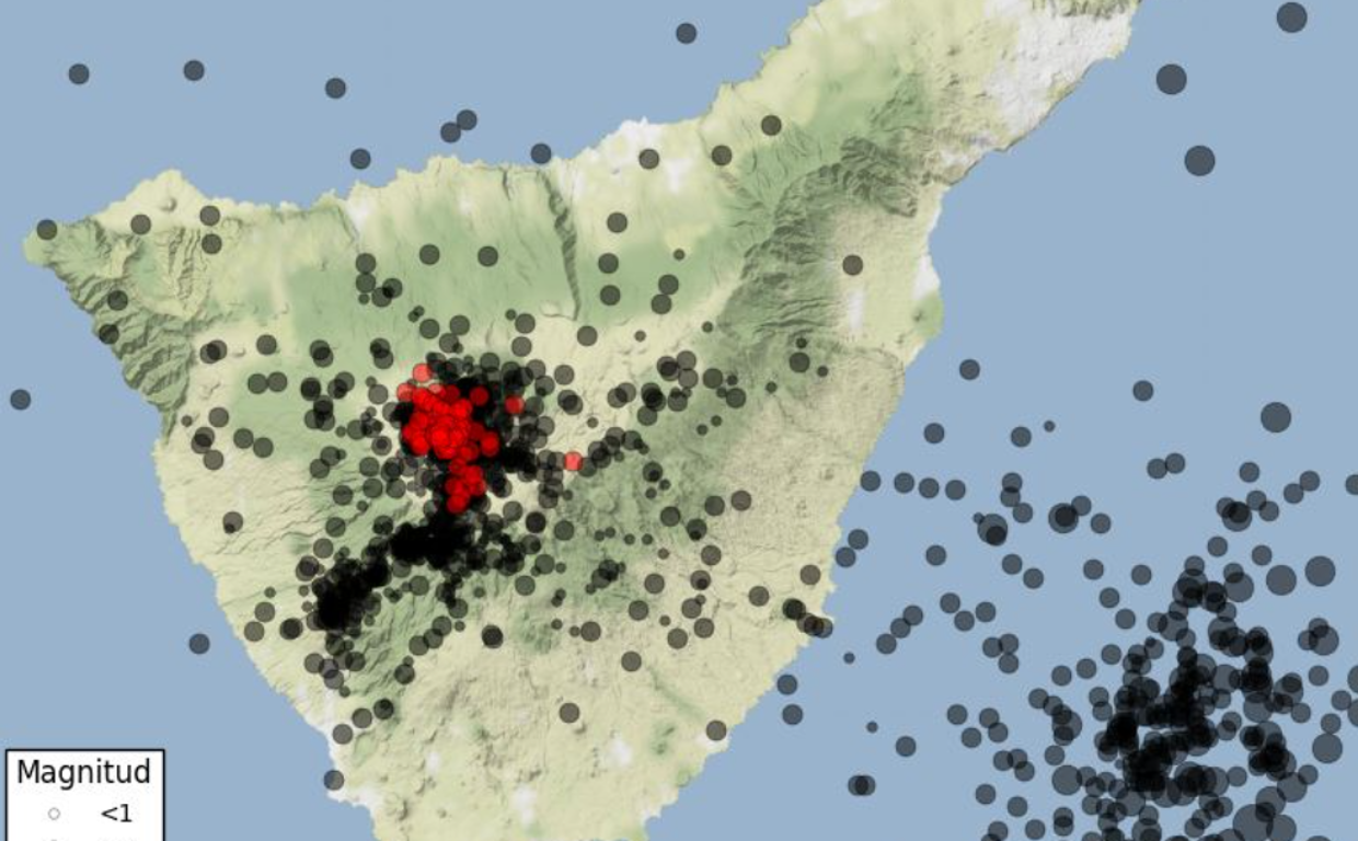
Albeit this article is about 630 low tectonic earthquakes under the Teide Volcano - in just 6 hours (and 630 in total) - I put this entry rather here into the Volcano thread, since those events happen right under the volcano (in 9-12 km depth)


ABC Spain writes following:

The Teide volcano trembles again with 630 earthquakes in less than six hours​

The Canarian Seismic Network operated by the Volcanological Institute of the Canary Islands (Involcan) detects from 5.50 a.m. on Tuesday, July 12, a new 'seismic swarm' located under Mount Teide with up to 350 events of very low magnitude.

At 12:30 p.m., Canary Islands time, the seismic swarm had already recorded more than 630 detected events, all of small magnitude. The events are located around Mount Teide, at depths between 9 and 12 km.

From Involcan they point out that this 'swage' has characteristics very similar to those registered in Tenerife on October 2, 2016, June 14, 2019 and June 10.

Thus, he indicates that "the most likely origin is the movement of fluids such as steam, gas or water, inside the hydrothermal system of the Teide volcano" while specifying that "it does not imply a greater probability of an eruption, but it does remember that Tenerife is still a volcanically active island."

translation via Apple

teide1-RR4rzUHCu5nBE8YW4XZn4SJ-758x470@abc.jpg
 
Vesuvio, Italy
13 July 2022

An accident happened at the crater of Vesuvio in Italy. Vulkane.net reports following:


Vesuvius: American tourist falls into the crater

- A young tourist plunged into the crater of Vesuvius
- He was rescued injured
- The man climbed over a barrier and wanted to take his selfie


Young man falls into the crater of Vesuvius

Vesuvius appears regularly in the news here, usually in connection with volcanic earthquakes, or when a new discovery is made in Pompeii. Today I am writing about the volcano because an accident happened there: an American tourist climbed over the barrier to an area marked as extra dangerous and allegedly wanted to take a selfie. [ :umm: ]

In the process, his smartphone fell out of his hand and slid down a steep slope on the inside of the crater. In an attempt to retrieve the device, the 23-year-old followed his phone and slid down the crater. His family and friends, who had also climbed over the barrier, went for help and the mountain guides rescued the casualty from his predicament on the steep slope. A rescue helicopter took the - apparently only slightly injured - man to hospital.

The episode will have legal repercussions, as the people involved are facing charges of illegal entry into the cordoned-off area. Allegedly, they did not even have a visitor's ticket, but sneaked into the crater area without paying admission. The incident happened at the weekend.

The young man was lucky in this case, because there are indeed crater areas where the walls drop more than a hundred metres vertically. The imposing volcanic crater has a diameter of 500 metres and is 300 metres deep.


Vesuvius is a 1281 m high Somma volcano

that dominates the Gulf of Naples. It can be described as the fateful mountain of the region, as it has erupted several times with catastrophic consequences. If a major volcanic eruption were to occur today, a good 1 million people would be at immediate risk. Evacuating them would be a major challenge.

Vesuvius is seismically active: a small earthquake swarm occurred on 3 July. Individual weak earthquakes are part of the daily routine. However, the quakes probably testify to a subsidence of the volcano, as a weak deflation has been measured in recent years.


End of Article


Photos from 3 June • Vesuvio 2006

I hope you don't mind, that I attach images I have taken myself at the crater rim of Vesuvio in 2006, just to illustrate the scenery up there. So, here it goes: All I can say, it is very steep up there... (but not always so obvious in photos). I also remember that accidents of falling tourists have happened before.

2006-06-03-16-14-33.jpg


2006-06-03-16-17-22-2.jpg
Gianni is standing close to the at the crater rim. However, notice that the "fence" is basically just a light metal chain separating people from the abyss in to the crater; In good and bad; because stronger fences would spoil the outlook and make things look pretty ugly.

2006-06-03-16-50-00.jpg

2006-06-03-16-50-54.jpg

from June 2012

2012-06-16-12-01-13.jpg
Daniel among the very rough lava stones near the abyss into the Vesuvio Crater.
 

Attachments

  • 2006-06-03-16-53-59.jpg
    2006-06-03-16-53-59.jpg
    121.3 KB · Views: 6
New eruptive pulse of Japan's Sakurajima volcano with high emission plume.
Located in the south of Kyūshū island .

Sakurajima Volcano Volcanic Ash Advisory: EXPLODED AT 2022-07-17/09:52 UTC OVER

Sakurajima volcano

Updated: Jul 17, 2022 17:21 GMT - 6 hours ago

stratovolcano 1117 m / 3,665 ft
Kyushu, Japan, 31.59°N / 130.66°E
Current status: erupting (4 out of 5)

Last update: 17 Jul 2022 (Volcanic Ash Advisory)

Sakurajima (also spelled Sakurashima or Sakura-jima, 桜島 in Japanese) volcano in southern Kyushu is one of the most active volcanoes in the world, and one of the few that are at present in constant (persistant) activity. Its ongoing typical activity range from strong strombolian to large ash explosions every 4-24 hours.
 
Indeed. From The Times of India:
Western Japan's Sakurajima volcano erupts, alert level raised to 5
I cannot copy/paste the text.

FYbuKH1UIAAONeS


And from South China Morning Post:
Japan’s Sakurajima volcano erupts, highest alert level raised, evacuation advised

  • Video shows red mass flowing down one side of the volcano, with projectiles shooting out and smoke, hard to see in the darkness, billowed upwards
  • Police say they have not received any immediate reports of injuries or damage following the eruption but some areas are advised to evacuate
A volcano on Japan’s Western major island of Kyushu, called Sakurajima, erupted at about 8.05pm local time on Sunday, the Japanese Meteorological Agency said.

There were reports of volcanic stones raining down at a distance of 2.5km (1.5 miles) from the volcano, NHK public television said. The eruption alert level has been raised to 5, the highest, with some areas advised to evacuate, NHK said.
There were no reports of injuries following the eruption, police said, or immediate reports of damage.
Video footage from Sunday’s eruption showed what appeared to be a red mass flowing down one side of the volcano, with red projectiles shooting out while smoke, hard to see in the darkness, billowed up.

Sakurajima is connected to the Osumi Peninsula on Kyushu, the country’s southwestern main island. Most of the city of Kagoshima is across the bay from the volcano but several residential areas within about 3km (1.9 miles) of the crater may be ordered to evacuate, NHK said.

Officials at Prime Minister Fumio Kishida’s office were gathering information about the situation, it added.

Sakurajima is one of Japan’s most active volcanoes and eruptions of varying levels take place frequently.
In 2019 it spewed ash 5.5 kilometres (3.4 miles) high, and in June 2018, a large plume of ash blocked out the sun after being released into the sky following an eruption at Sakurajima volcano.

Kyushu Electric Power’s Sendai nuclear power plant, which was the first to be rebooted under tighter safety rules adopted in the wake of the 2011 Fukushima nuclear plant disaster, is located just 50km from the volcano. No abnormality has been reported at the plant.


3:13 PM · 24 juil. 2022 - Sakurajima #volcano in Southwest #Japan is erupting today, prompting evacuation warnings by the #Japan Meteorological Agency. #JapanVolcano #Sakurajima

Edit: Added: I cannot copy/paste the text.
 
Askja, Iceland
28 July 2022

There has been a lift up to 35 cm at the Icelandic volcano Askja, which makes the likelihood for an eruption becoming larger now. A magma chamber is assumed to be present at only 2 km depth.


Vulkane.net writes following

0-2259720972.jpg

• Askja's ground elevation is up to 35 cm
• Scientists met to discuss the situation
• With inflation continuing, an eruption is becoming more likely

A little over a year ago, the previously deflationary trend of the Caldera volcano Askja changed and a phase of inflation began. So far, it has caused a ground uplift of up to 35 cm. The most likely explanation for this ground uplift is the inflow of magmatic fluids into the subsurface. IMO volcanologists suspect a magma body at a depth of only 2 km. The centre of the ground uplift is located a little to the west of Lake Öskjuvatn. From there, the magma body spreads horizontally.

Askja ground uplift could culminate in eruption

Yesterday, scientists met to discuss the situation. Magnús Guðmundsson, professor of geophysics, gave an interview to the Icelandic TV station RUV in which he said that the ground uplift is very fast and replaced a phase of deflation with ground subsidence that lasted a good 60 years. He expressed surprise at the speed of the ground uplift, noting that the comparatively low seismicity was unusual. Normally, with such strong inflation, one would expect significantly more earthquakes than is currently the case.

Guðmundsson commented, "Askja probably has to take quite a beating before it cracks and an eruption occurs." The scientist went on to say that Askja can be compared to a half-empty tank, as there has been ground subsidence there in recent decades. Now the tank has to be filled up even more before the predetermined breaking point is reached. Should an eruption occur, the geophysicist expects effusive activity, probably in the form of a fissure eruption. But if the eruption fissure were to extend into the lake, it could be explosive, producing phreatomagmatic eruptions.

The last time this happened was in 1926, when an explosive eruption created the islands in the lake. This eruption went unnoticed at the time, according to Professor Guðmundsson, although the eruption produced high rising ash clouds. The reason for this is probably the remoteness of Askja, which is located in the middle of the Icelandic highlands. (Source RUV)


END OF ARTICLE
 
Stromboli, Aeolian Islands - Italy
27 July 2022

The island volcano Stromboli produced a lava stream in the evening (albeit it appeared to have ceased later). German Vulkanet.net had following to tell:


Stromboli with lava flow on 27 July
28 July 2022 by Marc Szeglat

Stromboli_2022-07-28.jpg

🔸 A lava flow was seen on Stromboli last night.
🔸 The source was located at the edge of the northern crater sector
🔸 The lava flow triggered rockfalls

A lava flow began on Stromboli yesterday evening. As INGV reported in a special bulletin, the activity started at 19:30 local time (17:30 UTC). Lava poured from a vent in the northern part of the crater, near its outer wall, and made its way down Sciara del Fuoco. Numerous rockfalls came off the front of the flow. There was a slight increase in seismicity before the event began.

On the seismogram you can see that the tremor was slightly elevated until around 4.30 UCT. Apparently, the flow then stopped again. No particular activity is currently visible on the livecams. According to INGV, no particular ground formation was detected. The LGS, on the other hand, reported a stop of the tiltmeter shortly before the beginning of the lava flow.

Such short-lived lava flow events often occur in series and can be precursors of a larger event. It is in this context that I already placed the larger explosive eruption on Monday. There had been a Ml 3.0 earthquake in mid-July. It manifested itself just off the coast of the island, more precisely, off Sciara del Fuoco, and fits into the overall picture that a larger event could be brewing at the volcano.

The volcanologists' measurement data are by and large inconspicuous and only a few strombolian eruptions were registered. The only noticeable thing has been the rising carbon dioxide emissions, which had increased over the past few days. Yesterday, the LGS reported an emission of 931 tonnes per day.

Major eruptions at Stromboli are difficult to predict

At Stromboli, it is particularly difficult to predict major events based on the measured data. Stromboli is an open system that is always subject to some fluctuations. Since the magma ascent paths are free, there are usually no swarm quakes when magma rises. In phases of increased activity, an increase in earthquakes with very long periods is recorded. Usually, a particular ground deformation is detected only a few minutes before the eruptive event. Lava patterning lasting several days and frequent formation of short lava flows usually indicate a major volcanic eruption in the making. So it remains exciting on Stromboli.


END OF ARTICLE, translated with DeepL
 
Raung Volcano, Island of Java, Indonesia
28 July 2022

Raung is a massive 3332 meter high (10932 ft) volcano located in the very east, on the island of Java, Indonesia, near the the famous Kawa Iljen sulfur volcano. Apparently, the Raung volcano ejected a larger ash cloud, which is believed to have been of phreatic nature, since there where no volcanic related earthquakes/tremors.

The article had no photos attached, so I searched the internet for some to show the volcano's portrait, and made a map, so you can see where on Java this volcano is located.


volcanic-eruption-640x617-123262665.jpg


German Vulkane.net explained the event more in detail, as following:


Raung produced ash clouds


🔸 Indonesian volcano Raung erupted yesterday
🔸 Ash clouds rose 1500 m above crater level
🔸 Ash precipitation fell in localities

Bild_2022-07-28_111740678.jpg

Indonesia's Raung volcano erupted 4 times yesterday, producing ash clouds that rose up to 1500 m above the volcano's summit height, according to VSI. Local media reported ash fallout in neighbouring localities, which caused some concern among the population. All the more so because the eruptions were hidden due to dense cloud cover. There had apparently been no warnings and people were taken by surprise by the eruption.

The Raung's alert status was "green", although there had been a marked increase in seismicity since mid-July. Up to 100 quakes a day were recorded. However, the earthquakes were classified as tectonic tremors, which was probably the reason why no warning was issued. At the same time, the number of strong degassings increased significantly.

The eruptions yesterday produced seismic signals with amplitudes between 24-32 mm and lasted up to 173 seconds. So they were not very strong. Nevertheless, they could mark the beginning of a new eruptive phase at Raung.

Raung is located in the east of Java and is one of the volcanoes of the Ijen massif. Better known than Raung is the neighbouring Kawah Ijen, in whose crater sulphur is mined. Raung is 3332 m high and a real lump. Climbing its crater is not easy. In 2015, there was a prolonged eruptive phase during which the crater filled with lava and a pyroclastic cone grew. 5 years later, another, less powerful eruption series began. Last year, the volcano also appeared in the news on vnet. At that time, ash clouds were erupted and there was increased seismicity.

It is impossible to predict what will happen next at Raung. The relatively weak eruptions and the absence of volcanic earthquakes indicate that they were mainly phreatic in nature and that the ejected ash was old lava from the vent filling. However, it will only be possible to say more precisely after analysing the lava samples.


END OF ARTICLE • translated with DeepL


Images & Locations :

Raung_Volcano1.jpg

Mount+Raung-3218908728.jpg

Map_of_Indonesia.jpg_-2022-07-29-at-01.05.10.jpg
 
Sakurajima Volcano, Japan
31 July 2022


sakurajima.jpg

Yes indeed, another eruptive episode from this very active volcano in Japan. I thought to add some more information here, coming from German Vulkane.net, which wrote following:


At Sakurajima, volcanic ash rose up to 2700 m high

🔸 An increase in seismicity is observed
🔸 Ground uplift at the volcano stopped
🔸 Sakurajima with increase in seismicity


Sakurajima with increase in seismicity

On Japan's Cherry Blossom Island, the Sakurajima volcano continues to be active, producing ash eruptions several times a day. The ash rises from the crater Minami-dake and reaches heights of up to 2700 metres. The wind carries the ash towards the northwest.

The activity histograms show that not only the number of eruptions has increased, but also the frequency of volcanotectonic earthquakes. Yesterday, about 35 tremors were recorded. Sulphur dioxide emissions are at 2100 tonnes per day.

A report by the responsible institute states that a pyroclastic flow is said to have been produced during one of the eruptions of the last few days. There is no length information, but I suspect that it was a short stream moving in the upper part of the flank and was created by a lateral blowout/collapse of an eruption cloud. The observed expansion of the volcanic edifice stopped. It was triggered by magma inflation.

By March, there was also ground uplift at the submarine base of the volcano caused by inflation. The alert status, which had been set to the highest level "5" last Sunday, now stands at "3".

Evacuation orders have been lifted.

However, access restrictions to the volcano are in place. Researchers point out that it is particularly dangerous in a 2 km diameter zone around the Minami-dake and Showa-dake craters. One must expect impacts from volcanic bombs and pyroclastic flows could go off. The researchers do not foresee any further increase in activity. The report takes into account data up to 3 pm on 29 July. There were 18 volcanotectonic tremors on that day.

Sakurajima is located on a peninsula in Kagoshima Bay. While the cherry blossom island around the volcano is relatively sparsely populated, the big city of Kagoshima, 10 km away, is a different story. Almost 600,000 people live there. Large eruptions could have a negative impact on the population. In the immediate vicinity of the volcano, there are annual evacuation drills where residents have to gather at the ferry port in the shadow of the volcano.


END OF ARTICLE, translated with Deepl
 
Fagradalsfjall volcano
Fissure swarm 385 m / 1263 ft
Reykjanes Peninsula, Iceland, 63.89°N / -22.27°W
Current status: restless

Last update: 2 Aug 2022 (strong seismic activity continues with no signs of tremor so far)

Fagradalsfjall mountain is a tuya that erupted during the last glaciation under the ice shield. The broader Fagradalsfjall volcanic system comprises an area of eruptive fissures (fissure swarm), cones and lava fields in the southern part of the Reykjanes peninsula.
A strong seismic crisis began in the area near Fagradalsfjall since late Feb 2021, interpreted as intrusion of magma at shallow depth. This led to the first historic eruption of the volcano on 19 March 2021.
The seismic activity remains elevated and had been more frequent.
Nearly 3000 earthquakes in total have been detected since the phase began by the Norwegian Meteorological Agency, of which four were recorded with magnitude of 4 and more.
The first earthquakes depths measurements were located at approx. 5-8 km depth, but since 18:00 local time on 30 July have become shallower at depth of about 2-5 km.
At 17:47 local time yesterday, seismic instruments registered the strongest event so far with magnitude M 5.4 located northeast of Grindavík. Shakes were even visible in the live stream (see the attached M 5.4 quake video below). The earthquake was widely felt by inhabitants, some minor damages reported.
Magma continues to intrude under the surface and causes voltage changes NE of Grindavík and west of Kleifarvatn lake.
A similar scenario occurred in December last year, but doesn't seem to be powerful enough to trigger an eruption yet.
Source: Icelandic Meteorological Office volcano activity update 1 August 2022


Fagradalsfjall volcano, Iceland
3 Aug 2022

NEW ERUPTION HAS BEGUN !

fagradalsfjall-eruption002.jpg


Vulkane.net writes today following:

Volcanic eruption in the Meradalir valley of the Fagradalsfjall complex

In Iceland, the expected volcanic eruption started a few minutes ago (around 13:15 local time). A new eruption fissure opened in the Meradalir valley, which is located a little north of the old eruption site in Geldingadalir. The fissure is longer than it appears at first sight, because when the steam on the right of the picture clears, you can see that the fissure extends up the flank of the hill. A lava curtain is being produced from the fissure, consisting of a series of lava fountains several tens of metres high. Plenty of lava is flowing and about to flood the valley. Here is a livestream of the event.

Bild_2022-08-03_191636970.jpg

A report from Visir says that the eruption fissure opened in the area where the moss fire occurred last night. The assumption is that geothermal heat, or hot gases, or a small pre-eruption could have ignited the moss. Cigarette butts, my ass!

karte.jpg

In the meantime, there is already a first description of the location of the new eruption fissure. It is located on the west side of the Meradalir valley, about 1.5 km north of Stóra-Hrút. The fissure strikes in a northeast-southwest direction. On the cams, the first lava seems to have appeared at 13:18. In our Facebook group there is discussion about the length of the eruption fissure. I estimate it to be a good 150-200 m.

The seismicity has currently decreased considerably, just as it did last year after the first fissure opened.

fagradalsfjall-eruption12.jpg

Helicopters are circling over the eruption site and VISIR is providing us with a livestream. I took the liberty of saving some still images from the video, which I have used here in the article. I find it fascinating how an eruption fissure can open up so easily somewhere in the landscape. The prehistory of the eruption is equally interesting: magma ascent began in the Thorbjörn/Svartsengi area as early as January, and the eruption occurs in the Fagradalsfjall area. I would not be surprised if there had been a sideways migration of the melt here.


END OF ARTICLE
 

Trending content

Back
Top Bottom