Volcanoes Erupting All Over

Fagradalsfjall volcano, Iceland
3 Aug 2022

The link refers to a site which has a time line with various articles revolving the new eruption at Faradalsfjall volcano, albeit it is held in the Icelandic language.


4D2375852B56C3FC7E8F67DD4DEFB3DD67EA92E1EE84A42FCA961E9B2354B0A1_713x0.jpg

New Eruption

The Eruption began in the Merad valley of Reykjanesi in the second half of today, following intense tremors in the area in recent days. Earthquakes were clearly seen on webcams from the area and the continued presence of volcanoes was confirmed by Weather Service experts.

According to them, the blaze is located in the western part of the Meradian valley, about 1.5 km north of Stóra-Hrút. The fire appears to originate from a north-east-south-west fissure at that location. On first inspection of the web cameras, it appears to have come up on the surface at 13:18.

Þorvaldur Þórðarson, a volcanologist, says that the hole is small and neat. The activity is to contract into a certain gap and then will erupt from the gap rather than the crack.

It stretches about five hundred metres and the mercury is about ten to fifteen metres. The crack stretches from the northwest of Merad Valley up the hill to the north. The general public is asked to stay clear of the area while responding to requests, as stated in the police report. The indicator monitors the gas from the ground and from the air. Watch the broadcast below.

B713F0B14CAA6B5F9E53650429BF9C7B911311A9EE06598BCB6105C981C28C2F_713x0.jpg

DeepL, from Icelandic as "Swedish" to english


More images:

C3AB33C5BEF0D5EF794E607E80D7C6F2EC8106B78BB331203F97507E9EB43C9B_713x0.jpg2A413BE1BD4EC3561EDA6FF501909C39B9CCBDC8F88A65F17F3C664157E4F223_713x0.jpg03FB655A26F2EB0B16554C36A9F9BDAB8BF325BC0722AF6CE2C17E199B0A493D_713x0.jpg
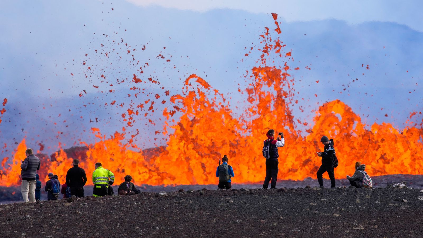
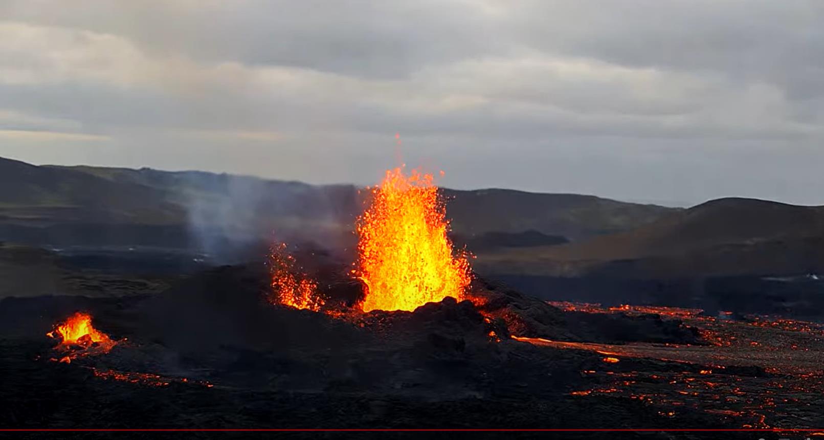
Photographer Eyþór Árnason took these impressive photographs in the Geldingadölum today. It's funny that people are immediately making their way to the cave to admire the view.


7A21915E05511FD9A84E901FC65904F8D4C5CC02B451FB5801A092731A87AAEF_713x0.jpg
This is a great photo taken by Baldvin Hlynsson on board an Icelandair plane on its way to Nice in France.
 
Fagradalsfjall, Iceland
4 Aug 2022

Two truly stunning drone images were shown at the Vulkane.net Facebook group, under the name "OZZO photography". I've personally never been a friend of drones of any kind... but when it comes to volcanoes and photography... I must say, wow - sometimes amazing work has been done by people in drone photography !

OZZO-Photography.jpg

297567463_10160154521003044_3490995407405949503_n.jpg

Patrice-Zwenger.jpg
This one is cool too, published under the name of Patrice Zwenger
 
Fagradalsfjall, Iceland
4 Aug 2022

And this is what German Vulkane.net Marc Szeglat wrote about the Icelandic eruption today:


0408002.jpg

The eruption in Meradalir continues

State: Iceland | Coordinates: 63.903, -22.273 | Eruption: Hawaiian

The volcanic eruption in Iceland continues and has not weakened significantly so far.

According to initial data, the lava output yesterday was about 30 cubic metres per second and produced many times more lava than during the initial phase of last year's eruption. The volume of intruded magma is estimated at 50 million cubic metres. Media reports mention a 300-500 m long fissure that opened up in the northwest of Fagradalsfjall.... A good part of the valley floor is already covered with lava. On the whole, the volcanic eruption is similar to last year's and there is no threat to infrastructure so far.

Model calculations have shown that this should not be the case in the course of the eruption either. In the model calculations, it was assumed that the volcanic eruption would last 200 days. This would presuppose that this time, too, the magma rises directly from a source in the Earth's mantle and not just the magmatic passage empties. Even if the probability is high that the eruption will be similar to the last one, there could still be surprises and fissures could open up at other locations that are less favourably situated.

The Civil Defence has called on the population and tourists to stay away from the eruption for the time being, but has refrained from setting up barriers. Initially, they wanted to clarify the situation and mark hiking routes. But the call apparently went unheeded, as thousands of onlookers made their way to the 17 km long eruption site. There is heavy air pollution from volcanic gases and smoke from burning moss. People were also reminded to observe drone flight regulations. These include that drones must not fly higher than 120 m and must remain within sight of the operator. It was warned that if there were repeated violations, flying drones would be banned for all.


END OF ARTICLE, DeepL translated

Oh, I forgot. At the Vulkane.net facebook group, there was a chart published, showing all earthquakes in the area within the past 24 hours.

297561152_10224957035245499_34567463623223861_n.jpg
 
Fagradalsfjall, Iceland
4 Aug 2022

A great video of the first day of the eruption in the Meradalir valley at Fagradalsfjall in Iceland. by © Volcano Chaser


Vulkane.net added another article about the ongoing eruption


0408003.jpg

Further News from the Fagradalsfjall eruption
4 August 2022 by Marc Szeglat

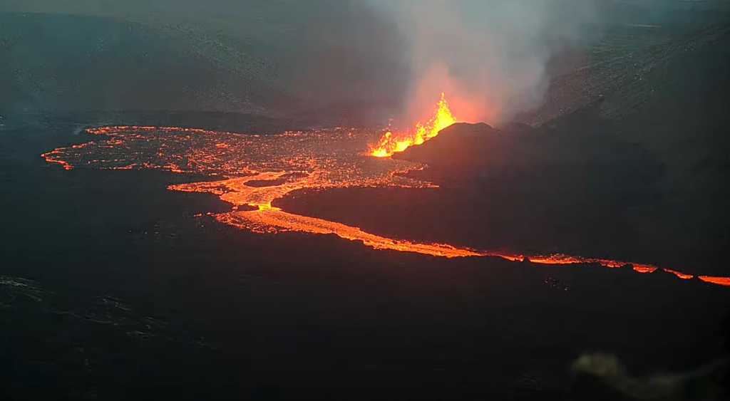
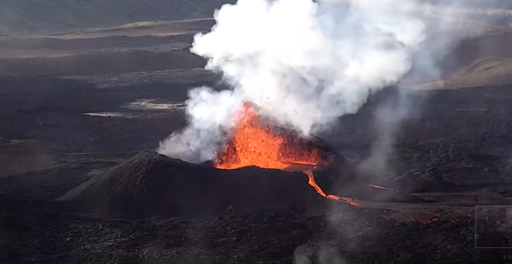
🔸 The eruption fissure is still active over a length of 135 m
🔸 A crater with a lava lake could form
🔸 The pressure in the magmatic duct is said to have increased further


Iceland volcanic eruption continues

The eruption continues, but the upper part of the fissure is already crusted. The length of the fissure varies. A report by mbl says that the eruption fissure was originally 260 m long. Now, about half of the fissure is still active and emitting lava. The rate of production has slowed considerably. The geoscientist Ármann Höskuldsson assumes that the eruption strength will continue to decrease and that a crater will form in the next 2 days. This usually happens at the lowest part of an eruption fissure. A lava lake could form in the crater.

As already mentioned, the initial phase of the current eruption was up to 5 times stronger than was observed during the eruption in Geldingadalir last year. At that time, about 5 cubic metres of lava per second were initially ejected, but instead of weakening, the lava output increased to 15 cubic metres per second. Moreover, the initial crack was much smaller at that time.

However, one must not forget that the eruption developed over the course of several days and that several fissures had formed during this period, with the centre of the eruption shifting several times. It is uncertain whether the eruption in Meradalir will be similar. The Icelandic geophysicist Páll Einarsson explained in an interview that the pressure in the magmatic passage would continue to increase, although the eruption is already underway. This would indicate that the eruption could last longer and take a similar development as last time.

But we know: reliable forecasts about the course of the eruption cannot be made. Nor can the duration of the eruption really be predicted, but perhaps the statements of the two geoscientists hit a trend.

The approximate location of the eruption has actually been pretty well predicted in some models over the last few days. The new fissure is on a line with previous eruptions, as shown by the chain of hyaloclastite mounds. They were formed during volcanic eruptions under the ice. What is striking is that they are all similar in size, suggesting similarly powerful eruptions. Before last year's eruption, volcanism on the Reykjanes Peninsula was dormant for more than 800 years. Now there seems to be a new eruptive phase, during which we can expect frequent eruptions in the coming decades. Maybe volcanoholics should set up a holiday cabin on Iceland?!

Yesterday evening, the first onlookers on their hike to the volcano already got into trouble and had to be taken care of by the emergency services. From the car park it is a 17 km walk to the fissure and back to the car. It leads uphill and downhill and can be quite strenuous.


kette.jpg
END OF THE ARTICLE
 
Faradalsfjall, Iceland
5 Aug 2022

From Iceland reports are raining tight with the new eruption - yet another article has appeared from german Vulkane.net together with a stunning image.

Albeit i should add, that this article focuses less on the current eruption, and on the question if a whole new eruption phase has started for the Reykjanes peninsula ? Before last years eruption, the area has been without volcanic activity for the past 800 years !


Iceland: New eruption phase on Reykjanes?
5 August 2022 by Marc Szeglat


1357638.jpg
Fissure and lava field. © mbl/Árni Sæberg

While the volcanic eruption in the Meradalir valley at Fagradalsfjall volcano continues, the debate has flared up in Iceland as to whether a new eruptive phase has indeed begun on the Reykjanes Peninsula. By eruption phase, we do not mean the current volcanic eruption, but rather a sequence of numerous eruptions that could take place on the peninsula in the southwest of Iceland over the next decades or even centuries. It cannot be ruled out that there will be eruptions along different crack systems. There were already considerations to this effect after last year's eruption, but now the probability seems to have increased.

Airport in the north to be expanded

The last eruption on Reykjanes was 800 years ago. It occurred in the 13th century, more precisely, between the years 1210 and 1240. In the west of the peninsula, eruptions occurred in 4 places. Lava flowed into the sea at least 6 times. Since then, Reykjanes has been considered a relatively safe port on Iceland, which is why a lot of relevant infrastructure has been settled here. The island's capital Reykjavik - where most Icelanders live - is located in the east of the peninsula. In its central section there is the Svartsengi geothermal power plant, the tourist magnet Blue Lagoon and an aluminium smelter.

To the west is Keflavik International Airport. It is a matter of particular concern and a possibility is being sought to create a second airport with international connections. There are several possible candidates. The simplest solution seems to be to expand the regional airport in Akureyri. In fact, expansion of the airport had already begun last year, but the expansion stalled because apparently the money ran out.

Now the Icelandic government is trying to raise funds quickly to complete the new terminal and apron. The German Condor had planned to start flights to northern Iceland as early as next year. Maybe then the flight situation in Iceland will relax, because in the short term it is practically impossible to get affordable flights during the season, which is a pretty nasty business for volcano spotters.


Bild_2022-08-05_103551313.jpg

Current situation at Fagradalsfjall

On the livecam at Fagradalsfjall you can see today that the fissure has closed further. The activity is limited to the lower part of the fissure, from which lava fountains are rising in 3 places. They are now higher than they were at the beginning of the eruption. After the flat bottom of the Meradalir valley was quickly flooded and a secondary lava lake formed, the lava is now flowing away in a stream.


END OF ARTICLE


Additionally

I found a map at their (Vulkane.net) facebook group, showing the outlines of the current eruption in comparison with last years eruption. Also a second map (below) showing various parameters revolving the current eruption, such as volume, discharge, and area of lava.


297808160_5310502919026099_2688519755950163004_n.jpg

297792356_5310502875692770_4337092225677062255_n.jpg
 
Mauna Loa & Kilauea, Hawai'i Big Island, USA
5 Aug 2022

An impressive USGS time lapse showing how the Halema'uma'u creater floor is rising within the Kilauea crater.


This timelapse sequence shows activity in Halema‘uma‘u, at the summit of Kīlauea, from March to August. The video shows the rise of the crater floor due to lava supplied beneath the surface crust, lifting the crater floor in an "endogenous" process. In addition, lava flows erupt sporadically and resurface portions of the crater floor.


Volcanoes in Hawaii on 5 August 2022
by Marc Szeglat

Bild_2022-08-05_151219820-1024x683.jpg

Hawaii is home to 2 volcanoes that are classified as active.

They are Mauna Loa and Kilauea. A third active volcano is located off the coast of Big Island. This report, however, is about the two fire mountains on the island. The USGS published an interesting video about Kilauea, which I would like to share with you. It shows the ground uplift in the Halema'uma'u crater due to lava lake activity.


The time-lapse video

was compiled from livecam images and shows the ground uplift of the summit crater on Kilauea. The ground rose as a result of lava lake activity, which gradually fills Halema'uma'u crater with lava. The video was taken between March and early August. But it only shows part of what happened, because the eruption already began on 29 September 2021.

Since then, the crater has filled up by 133 metres.

A good 98 million cubic metres of lava were needed to lift the ground. Material that was previously inside the earth. However, it is not only lava that flows out of the earth, but also gas. Sulphur dioxide is emitted at a rate of 1900 tonnes per day. Although Kilauea is erupting, the ground continues to rise throughout the summit area as more melt flows into the magma reservoir than escapes from the crater. Inflation has already exceeded pre-eruption levels again. The question is whether magma will soon flow underground again via the volcano's ostrift and accumulate in the Puʻuʻōʻō crater area. So far, it continues to be quite calm there, with only minor ground deformation recorded.

Mauna Loa with ground deformation

Ground deformation was also present in the area of the Mauna Loa summit caldera when a swarm earthquake occurred there on 3 August. It was 1.5 µrad, which is not very much, but seems worth mentioning in view of a moderate swarm quake. The ground uplift was at least partly caused by magmatic fluids accumulating under the volcano. Most of the hypocentres were at a depth of 3 km. The swarm earthquake was composed of 90 tremors. A total of 206 weak earthquakes were recorded in the Mauna Loa area within one week.


END OF ARTICLE
 
Fagradalsfjall, Iceland
6 Aug 2022

The eruption continues, but bad weather is hampering the view of the volcanic spectacle. Further below is a fascinating video, especially when you're listening to the sounds the volcano makes ... Like a pot of thick syrup boiling with deep, guttural sounds.


06082201.jpg
Drone photo of the eruption fissure. © mbl/Ágúst Óliver Erlings


German Vulkane.net wrote today following:


Fagradalsfjall eruption continues
6 August 2022 by Marc Szeglat


🔸 The eruption at Fagradalsfjall continues
🔸 The weather will remain bad for the next few days
🔸 Many hikers not properly equipped


Iceland's volcanic eruption continues in bad weather

The new volcanic eruption in Iceland continues today, but there is not much to see on the LiveCams since yesterday afternoon: the weather is bad and the forecasts for the next few days suggest that there will be few views of the eruption site in the Meradalir valley. This leaves room for speculation as to whether the eruption will develop as it did last year. If so, the activity will be reduced to a vent around which a new crater will form along with a cinder cone. Last year, lava fountains several hundred metres high were produced from such a vent at times.


🔸 CLOSE UP / FLYOVER VIDEO OF THE ERUPTION

(I could not get the video properly embedded here other than afacebook page which required login - so instead i copied the adress to the video itself, and hopefully it plays for you.)

The image above is from a drone video filmed by Ágúst Óliver Erlings for mbl. Well worth seeing! Such footage naturally motivates many onlookers to make their way to the eruption site. In the meantime, the path has been marked and is a continuation of hiking route A, which was already created last year for the eruption in Geldingadalir. You can also walk route B, but there is only a distant view of the eruption from its end point.

The emergency services at the eruption site complain that many hikers are not adequately equipped for the 17 km hike and some hikers are also in poor physical condition. Good footwear, rain gear, torch and water are essential when setting out. Walking poles and a breathing mask are recommended. It is also a good idea to bring bandages and, if necessary, an elastic bandage to treat sprained ankles.

1000 onlookers

Employees of the Þorbjörn rescue team from Grindavík reported that a good 1000 people visited the eruption site yesterday. At 3 a.m., about 80 people were still at the site. 3 people had to be treated by the rescue forces because they had injured their legs on the hike. Despite the marked path, the terrain is rough.

There are also warnings of air pollution from volcanic gases and fire smoke emanating from burning moss. Depending on the wind direction, the gas situation can change quickly. There are corresponding wind forecasts and air pollution maps on the IMO site.


END OF ARTICLE


Edit:

298153864_5313957388680652_3289285978532199453_n.jpg
 
Last edited:
Fagradalsfjall, Iceland
8 Aug 2022

The access to the eruption site has been temporarily closed. Vulkane.net writes following


Bild_2022-08-08_104857938-1024x563.jpg

The access to Fagradalsfjall has been closed temporarily
August 8th 2022 by Marc Szeglat


🔸 Reason is the bad weather
🔸 Pulsating lava fountains were observed
🔸 Closure of access to the eruption at Fagradalsfjall

The eruption in Iceland continues, but now closed to the public! Yesterday evening, the Civil Defence decided to temporarily close access to the volcano. The reason was the continuing bad weather with fog and wintry conditions. Many poorly equipped hikers stumbled through the fog. Among them was a family with 2 small children (5 and 6) who were already exhausted on the way there and had to be carried by the father. He carried one child in a seat on his back, the other in front of his chest, so that he could no longer see where he was stepping.

Concerned fellow hikers alerted the rescue services, who then rescued the family from the terrain. Not without reluctance on the part of the father. Such scenes happen again and again. Many people underestimate nature and overestimate themselves. A volcanic eruption is not a children's playground and even though I always advocate open access to volcanoes, everyone should be aware of the dangers and risks and respect boundaries. It's one thing to put yourself in danger, it's quite another to take your charges with you. In my opinion, children under the age of 10 have no business being near a volcanic eruption; it is better if they are 12 or 14. Of course, this does not minimise the danger of an eruption, but children's understanding and physical capacity increases. It is also clear that early exposure to toxic gases can have particularly negative consequences. But back to the volcano.

A post was shared in our FB group after which a hiker described that the ground 1 km from the current eruption site was hot and that moss fires had occurred. Accordingly, there is speculation that magma is just below the surface and that new fissure openings could occur away from the current eruption site. In fact, the eruption centre shifted several times during last year's eruption.

Media reports say that the lava fountains started pulsating yesterday and were up to 100 m high at times. I could not observe such high fountains on the livecam. What has become much higher is the crater wall along the active part of the eruption fissure. The seismicity is decreasing. The tremor relatively stable, with a slightly decreasing trend. However, it does not signal an imminent end of the eruption.


END OF ARTICLE
 
In the last 24 hours, through the monitoring systems of the Popocatepetl volcano, 27 low intensity exhalations were detected, accompanied by steam, volcanic gases and sometimes light amounts of ash.

Additionally, a minor explosion was recorded at 08:39h local time (13:39 UTC). Also a volcanotectonic earthquake was recorded yesterday at 15:49h (local time) with a magnitude of 2.2.

Minor explosion of #Popocatepetl volcano at 8:39 am with low ash content and height of 1.1km in West-Nortwest direction.
Volcanic Alert unchanged at Yellow Phase2
August 10, 2022
 
Ioto (Iwo-jima), Japan
12 Aug 2022

ioto-iwojima-volcano-eruptions-during-july-2022.jpg

Ioto (Iwo-jima) erupted in Japan
12. August 2022 by Marc Szeglat

State: Japan | Coordinates: 24.75, 141.29 | Eruption: Submarine


As the JMA currently reports, the island volcano Ioto (also known as Iwo-jima) erupted in mid-July 2022. For the first time in 1000 years, a magmatic eruption occurred just off the southern coast of the island. Images have been released showing faint Surtseyan eruption clouds rising. Water, mud and tephra were thrown a good 30 m high.

The eruption series began on 11 July. In the following days, submarine explosions occurred every 5 minutes. They continued until at least 4 August. The rocks that washed up were porous tephra. The lumps were up to 120 degrees hot inside. The eruptions occurred a good 900 m from the coast. Satellite photos showed water discolouration and upwelling.


First magmatic volcanic eruption in 1300 years

The last magmatic volcanic eruption on Volcano Island occurred about 1300 years ago. However, the island has not been idle, having risen 40m since its discovery by Captain Cook in 1779. In April 2022, it was found that the annual rate of uplift is currently just over 1 m. An exampleless inflation of magmatic fluids. This is accompanied by more frequent phreatic eruptions.

Ioto is part of the Japanese Ogasawara archipelago, which I have reported on here several times. It lies a good 1000 km south of Japan and is home to the active island volcanoes Nishinoshima and Funka Asane, which erupted in March 2022.

Although Ioto is a relatively small island, the associated volcano is anything but. The current fire mountain, of which only the tip rises above water, formed in a 10 km diameter caldera that was formed 100,000 years ago. Another large eruption 2700 years ago produced a lot of tephra, which was deposited underwater. There is also evidence of large pyroclastic flows. Therefore, volcanologists are watching the volcano with a wary eye.

END OF ARTICLE


_-2022-08-13-at-21.02.47.jpg
 
Taal, Philippines
12 Aug 2022


Taal with strong degassing
by Marc Szeglat

Taal-Volcano-2022.jpg


🔸 Taal volcano emitted 13572 tonnes of sulphur dioxide.
🔸 There is inflation under Volcano Island and in the west of the caldera.
🔸 Seismicity is comparatively low.
🔸 Activity increase at Taal Volcano


State: Philippines | Location: 14.002; 120.99 | Eruption: Fumarolic

The Philippine Taal volcano again increased its sulphur dioxide emissions. While yesterday it was 6099 tonnes per day, PHILVOLCS reported 13572 tonnes today. A lot of gas condenses and a 2800 m high steam cloud can be seen rising, which admittedly consists mainly of H2O. Not only do volcanologists warn of the health consequences of VOG, but there are also reports of residents complaining of breathing difficulties, sore throats and watery eyes.

Since the resumption of heavy degassing, something else has changed at the volcano: While there was talk of a slight deflation of the caldera before, there is now inflation again: the ground is rising in the western part of the caldera, but also under Volcano Island. Only in the eastern part of the collapse caldera is slight ground subsidence recorded. The situation was similar in the months before the eruption in the winter of 2020, although at that time there was also stronger quake activity than we are experiencing now. PHILVOLCS recorded 5 volcano-related earthquakes in the last 24 hours. The more frequent the quakes, the greater the probability of a volcanic eruption.

We remember: the Taal erupted on 12 January 2020.

First, phreatic eruptions began, which then quickly increased to phreatomagmatic eruptions. Volcanic ash rose so high that it reached the stratosphere. The ground in parts of the caldera rose very quickly, causing a river that flows into Lake Taal to run dry. In the weeks before the eruption, a seismic crisis began. There were up to 140 earthquakes a day. Shortly before the volcanic eruption, there were earthquakes with magnitudes in the 4 range. But the eruption subsided relatively quickly without the expected catastrophe and the situation de-escalated. Last year there were some phreatic eruptions, at times when sulphur dioxide emissions had also reached high levels. However, there was no inflation at that time.

As there is most likely still residual melt in the system, which accumulated in the magma body during the last 2 years, the new heating phase could be faster than before. Especially phreatic eruptions could occur at any time. However, it is not certain that new eruptions will occur, but the probability is there.


END OF ARTICLE
 
Fagradalsfjall volcano, Iceland
13 August 2022

1308002.jpg


Eruption at Fagradalsfjall in Iceland continues

1308001.jpg

The volcanic eruption in Iceland's Meradalir continues and the eruption fissure at Fagradalsfjall volcano is spewing lava. The protocrater in the lower fissure area continues to close and in a few days it will have closed. Probably a breach will remain open for the time being, through which the lava will flow out. The close-up shows very well the growing crater walls, but also the lava fountains that eject melt several tens of metres high. It feeds a lava flow that is heading east. The panoramic photo shows that the flow is not as long as it was two days ago. The lava front has retreated a good distance from the valley exit. But should stronger thrusts occur, it will reach it quickly.

trem.jpg

The tremor is stable, with the restriction that there was a brief drop in the morning hours, which manifested itself in a negative peak. It was the first of its kind since the beginning of the eruption. The question is whether lava pulses will occur again soon, as we saw last year. During the first weeks of pulsating activity, lava fountains were produced that rose several hundred metres. In return, there were pause intervals when the eruption stopped.

The earthquake activity has clearly decreased. The stress transferred from the rising magma to the tectonic faults has been relieved. Apparently, magma ascent and outflow through the eruption fissure are in equilibrium. The ascent paths are free. The pressure of the initial eruption was greater this time than last year. At that time, it was not enough to keep the initial eruption fissures alive longer, so several fissures gradually formed. At the moment, it looks as if no new eruption centres will form, but we know how it is with the dynamics of an eruption: everything is in flux.


END OF ARTICLE
 
Fagradalsfjall, Iceland
16 Aug 2022

More info about the ongoing Meradalir eruption on Icelance, which Vulkane.net had an article about today. Additionally i collected a few photos revolving the eruption, which i will attached in the end of this entry.


New data on Fagradalsfjall
by Marc Szeglat

Bild_2022-08-16_103137576.jpg

As the Meradalir eruption continues, new data on the volcanic eruption was released yesterday. It has also been suggested that the two eruptions of 2021 and 2022 will be named the Fagradalsfjall fire, while the individual eruptions will be named after the valleys where the main fissures were located. The 2021 eruption would thus be the Geldingadalir eruption, while the current eruption would be called the Meradalir eruption, i.e. the same as I already practice here.

But now to the data: The new lava field covers an area of 1.224 square kilometres and the volume of lava produced is reported at just over 10 million cubic metres. At the weekend, the production rate was still 10.4 cubic metres per second, about one third of the output of the initial phase. The average thickness of the lava field is about 8 metres. In some places the value is 22 m. So a lot of lava has accumulated in a short time. The tremor is stable and the seismicity is decreasing. The magma ascent paths are clear.

If you look at the LiveCam, you can see that the crater wall has now closed and formed a cone. The breach has also closed during the night, but it is still a little shallower than the rest of the crater rim, so that the lava flow can drain there. Otherwise, a lava pond is bubbling in the crater and comparatively small lava fountains are being produced. They could rise higher if the crater opening were to shrink. The rate of production has continued to decrease.

Yesterday evening, the lava output increased briefly and the lava flow picked up speed. It flowed eastwards again and approached the pass at the mouth of the valley, but without crossing it. Last year, when the lava flowed over similar passes, spectacular lava falls were created. Of course, it is uncertain whether this will happen again. Volcanic eruptions are very dynamic, but rarely follow exactly the same course. A circumstance that makes things exciting.

Update 14.00: The University of Iceland has just published the latest data. The lava output has shrunk to 4.1 cubic metres per second.


END OF ARTICLE


297887473_10224823363789182_3845675065944316466_n.jpg 297425766_10224823363989187_86352164906436530_n.jpg
Agnieszka-Mrowka.jpg Patrice-Zwenger-3.jpg
298983160_5326426534100404_7562001111419096866_n.jpg
298834869_5326426520767072_6854296205672264805_n.jpg
299675390_438157415019909_2308400032175594915_n.jpg
Madelon-Dielen-42D16BB3-40CA-41B8-A1C5-F31CA2C2D10C_1659806443.jpg
Patrice-Zwenger,-Meradalir-eruption-Day-1.jpg Patrice-Zwenger,-Meradalir-eruption.jpg
Several images made by Patrice Zwenger, while the first three photos were made by Agnieszka Mrowka
 
I think this event is related to this thread

In #Hokkaido #Japan 🇯🇵 
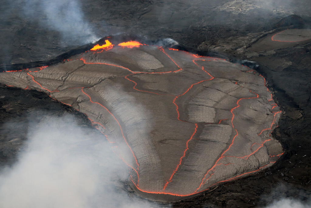
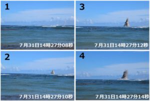
in the city of Oshamanbe, a geyser of water appeared in the middle of the forest last August 8 and has not stopped since.
The plume rises up to 30m high with a temperature of 22a23°C.

Natural geysers on Earth are not common; there are fewer than 1,000 worldwide, and about half of these are in Yellowstone National Park. Other large geyser fields in the world include the Valley of Geysers, in the Kamchatka Peninsula in Russia; El Tatio, in the northern Chilean Andes; Geyser Flat, Whakarewarewa in the Taupo Volcanic Zone in New Zealand; and the shores of Lake Bogoria in Kenya. These geysers are sensitive to environmental changes.

Geysers attract researchers from multiple disciplines in part because they provide natural laboratories to study processes that may be similar to those operating in volcanoes. Geysers also provide an opportunity to measure geophysical signals before, during, and after repeated eruptions. An improved understanding of geyser behavior may yield insight into other intermittent processes in nature that result from localized input of energy and mass, and is also critical for the preservation of these spectacular natural phenomena, so that humans do not influence their activity.

geysers are uncommon because they require a combination of heat from recently active magmatic systems, water, and geological deposits with abundant fracture networks. Together, these features create reservoirs that allow hot water to accumulate and then be discharged in discrete events.

 
Nevado del Ruiz volcanostratovolcano
5321 m / 17,457 ft
Colombia, 4.9°N / -75.32°W
Current status: erupting

The explosive activity at the volcano continues.

The Servicio Geológico Colombiano volcano observatory (SGC) registered a vigorous vulcanian explosion at the volcano at 17:51 local time yesterday.

A grey plume of ash rose to an altitude of 26,000 ft (7,900 m) dispersing slightly west-northwest direction.

The eruption was being visible from Manizales town and via surveillance cameras installed in the vicinity of the volcano.
No ashfall has been reported yet.
The alert status remains at Yellow.
Source: Servicio Geológico Colombiano volcano activity update 19 August 2022

 
Back
Top Bottom