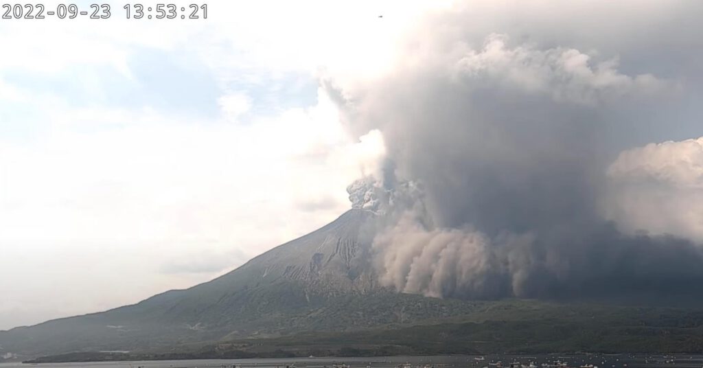
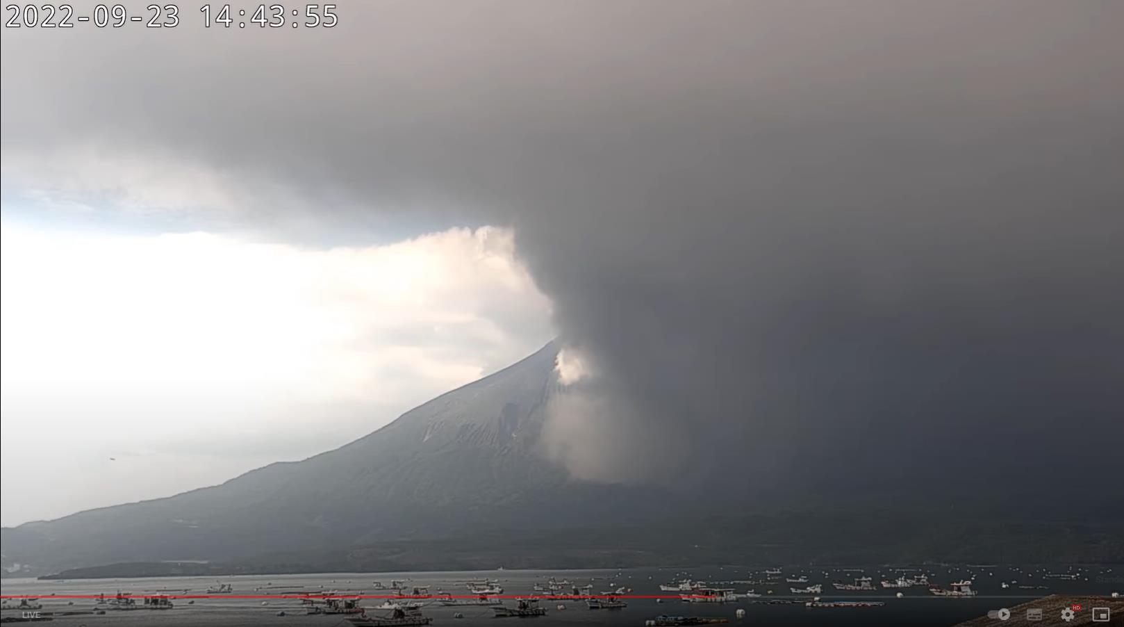
Volcanoes Erupting All Over

Anomalous uplift and series of deep tremors in Eifel Germany, volcanologists have now started a large-scale investigation under the leadership of the German Research Center for Geosciences (GFZ).

(Machine translation):

Researchers start eavesdropping on 800 volcanoes in the Eifel

Below the Laacher See lies a complex of 800 volcanoes.

Df1paw/ CC-by-sa 4.0 Below the Laacher See lies a complex of 800 volcanoes.

Thursday, 09/22/2022, 10:44 am

The volcanic area under the Eifel is actually considered an extinct super volcano. But there's a rumbling underground. Is there still an active volcano? A large measurement campaign is now to find out.

Hidden fire: Something is happening in the volcanic area below the Eifel - deep tremors and uplift of the subsoil indicate ongoing activity. However, what is behind it and whether the Eifel super volcano will become active again is uncertain. A large-scale measurement campaign is now intended to provide more clarity. A dense measuring network of highly sensitive geophones is intended to show what the magmatic system under the Eifel looks like and how deep the volcanism is sleeping there.

Around 13,000 years ago, a super volcano erupted in the Eifel, burying half of Central Europe under ash and lumps of lava. The explosive eruption of the Laacher See volcano ejected around 20 cubic kilometers of material and temporarily blocked the Rhine. Ash clouds traveled as far as northern Italy and Russia. Since then, the around 800 volcanoes of the Eifel complex have been dormant - there have not been any major eruptions.

Anomalous uplift and series of deep tremors​

However, the Eifel volcanism does not seem to have died out completely: the latest GPS measurements show that the subsoil in the Eifel region is rising to an unusual exten . In addition, since 2013, low-frequency earthquakes from the lower crust and upper mantle have been regularly registered in this region. Such earthquakes can be an indication that liquids or gases in the earth's crust are rising. These small tremors are generated by vibrations in rock crevices.

But what exactly does that mean for us? Normally, subsurface uplift and seismic tremors at volcanoes indicate that magma and volcanic gases are rising and the underground magma chamber is refilling. However, it would also be possible that under the Eifel simply hot liquids and gases are in motion without a new eruption threatening in the foreseeable future.

measuring network
A dense network of measuring devices around the Laacher See is intended to clarify structures and processes of the Eifel volcanism.© GFZ

350 geophones are supposed to eavesdrop on underground processes​

In order to create more clarity about what is happening under the Eifel, volcanologists have now started a large-scale investigation under the leadership of the German Research Center for Geosciences (GFZ). The "Large-N-Experiment" examines the underground of the Eifel more precisely than before. This could clarify what is moving in the earth's crust. In addition, the experiment will help the researchers more accurately image and map the magma chamber of the Laacher See volcano and the rest of the volcanic area.

Employees from the universities of Kiel, Mainz, Frankfurt and Cologne , the GFZ and the state earthquake service of Rhineland-Palatinate are currently working together in the Eifel for the large measurement campaign . They set up around 350 geophones in the districts of Mayen-Koblenz and Ahrweiler - sensitive measuring instruments that listen to the underground and record even weak seismic vibrations.

“Look deep underground”​

"With this experiment, which is unique in Germany, we want to look deep beneath the earth's surface and find out how the subsurface is made up and what is happening there, i.e. observe the dynamics. Above all, it's about volcanic activity," explains project manager Torsten Dahm from the GFZ. According to the volcanologists, there is no danger of an early eruption in the Eifel. Nevertheless, it is important to research and monitor what is happening underground.

The experiment is expected to last about a year and will register both earthquakes and background noise. The dense measuring network enables a higher resolution than previous investigations. Because the geophones also continuously record the measurement data over a year, the volcanic processes in the subsoil can be better characterized and monitored based on the localization of the seismic signals.

"If we have a better understanding of the processes and conditions underground, we can compare the data with those of active volcanic areas," explains Dahm. Then we can also better assess what the rumblings underground mean – how deep the volcano is asleep, if you will.”

The original of this article "Researchers start eavesdropping on 800 volcanoes in the Eifel" comes from scinexx.
 
Sakurajima, Japan
23 Sep 2022

It is known that Sakurajima has many short outbursts for most of the time - albeit this time, it was a very ash laden ejection / flow - something I have not seen before, at not like this. German Vulkane.net reported following in an article:


saku-pf-03.jpg

Volcanic eruption at Sakurajima generates ash flow

A major eruption occurred on Sakurajima in Japan this afternoon. It manifested from Minami-dake and started around 13:35 local time. The eruption developed very slowly and after a little over 10 minutes the eruption cloud began to collapse, with ash drifting towards the southeast and falling to the ground. An ash cloud then spread out on the ground, which looks like a pyroclastic flow in the time-lapse video below. In the real-time footage, however, the progress of the ash on the ground is very slow, and I think it lacked the hot gas cushion on which pyroclastic flows move, so I hesitate to call it a real pyroclastic flow.

However, volcanologists from the JMA have been warning for a few weeks that pyroclastic flows could occur. Let's see how the scientists on the ground assess the situation. The main part of the ash stream seems to have flowed eastwards and perhaps a different picture emerged from a different perspective.


The front of the ash-rich flow almost reached the base of the volcano in the south and stopped just before the coastal road. On the LiveStream you can see that several boat owners moved their boats to safety and took flight. To the east, the ash flow appears to have travelled a greater distance and may have reached the area of the lower Lahar embayments. Nearby there is a monitoring station with another livecam, but it is not open to the public. Images from there could be exciting if shared by researchers. The VAAC Tokyo registered volcanic ash at an altitude of 3000 m during a previous eruption. The ash cloud drifted towards the southeast.

Update: After a considerable delay, a new report came out, according to which the ash cloud rose to 4000 m.


END OF ARTICLE
 
Sakurajima, Japan
24 Sep 2022

Oh, there is more. The article must just been published by Vulkane.net reporting about more ash laden eruption events occurred at Sakurajima ! Albeit the image below appears (to me) being from the same main event, which the time stamps confirms. But there seem to have been been shorter outbursts later on (from which neither the article, video nor I have any images from)


saku-pf-01.jpg

Sakurajima with further ash eruptions

State: Japan | Coordinates: 31,581, 130,659 | Eruption: Explosive

There were further ash eruptions at the volcano in Kagoshima Bay. Compared to the volcanic eruption yesterday at noon, they were much more short-lived. The largest eruption produced volcanic ash up to an altitude of 3700 m. The ash plume drifted up to the top of the volcano. The ash plume drifted towards the southeast. Seismicity is slightly elevated.

A report from the JMA indicates that during the observation period 19 September to 23 September (3 pm), there were some eruptions in which large pyroclastic blocks landed up to 700 m from Minamia-dake. Sulphur dioxide emissions were 1900 tonnes per day and were reported to be high. There were few volcanotectonic earthquakes. So, business as usual and there was no sign of a major eruption brewing. This actually manifested itself at the end of the observation period mentioned, but did not move into the report. That will probably be the case on Monday.

Video of the previous day's eruption


Here is another video extracted from the recordings of yesterday's livecam footage. During the comparatively long eruption, a gravitationally induced "ash stream" flowed over the eastern and southern slopes of the volcano. Ash flow here in inverted commas because this term is actually used for particularly large pyroclastic flows, but here it is meant to refer to an event in which no real pyroclastic flow had yet formed. Basically, the ash cloud collapsed: the ash sank to the ground and flowed relatively slowly down the volcanic slope without sliding on a hot gas cushion. Although such events do not have too much destructive potential, a volcano walker who gets caught in such clouds can run into serious problems. The volcanologists from the JMA explicitly point out the restricted access to the volcano and warn against pyroclastic flows and volcanic bombs.


Suwanose-jima with eruptions

State: Japan | Coordinates: 29.64, 129.72 | Eruption: Vulcanian

Further south of Sakura-jima is the island volcano Suwanose-jima. This volcano is also represented in the VAAC reports. According to these reports, volcanic ash rose up to 3700 m high. As it was relatively windless, the ash cloud dispersed around the volcano and did not drift in any particular direction. Seismicity is slightly elevated.


END OF ARTICLE
 
During the early hours of Tuesday morning, the Popocatepetl volcano recorded two explosions with low ash content, which left a smoke of 1.5 kilometers, reported the National Center for Disaster Prevention (Cenapred).

The agency detailed that the minor explosions occurred at 04:54 and 05:09 hours of this September 27, also indicated that the smoke column was directed to the northwest.
 
Popocatepetl volcano emits 176 exhalations, four explosions and tremor

The Popocatepetl volcano presented moderate activity in a 24-hour period, during which time four explosions, an hour of emission sequences, tremor and 176 exhalations were recorded, accompanied by columns of water vapor, gases and sometimes ash.

According to the report of the National Center for Disaster Prevention (Cenapred) there were 17 minutes of tremor, i.e., movements characteristic of a volcano due to the passage of magma at a depth of several kilometers.

The tremor is produced by the magma hitting the walls of the magmatic chamber or in the outlet conduit and by the explosions of gas pockets or the blows of solid blocks torn off and dragged in the ascent against the walls of the volcanic chimney.

Explosion of #Volcano #Popocatépetl in #Mexico minutes ago 🌋🇲🇽.
Emission column approx 2km high. Volcanic alert unchanged at Yellow Phase2.
 
Yes there have been reports of increased activity at Stromboli volcano, north of Sicily, e.g. a lava stream was flowing, only days earlier and tremors were increasing. So, German Vulkane.net was drawing parallels to similar signs prior earlier, sudden pyroclastic clouds a couple years ago, wondering if the might be in the works. Well, apparently it was.

I didn’t report on it yet, because was/i am swamped with work and articles for the moment.
 
Stromboli, Sicily - Italy
11 Oct 2022

I encountered two fascinating images made with a drone flying near/over the Stromboli volcano yesterday. The volcano has been acting up lately, and still appears to be very active. Later I'll write more about it (via the german held articles from Vulkane.net)

311576509_482139593976811_8364972485224776072_n.jpg

311589370_482139590643478_2121290229521424815_n.jpg
 
Nevados de Chillan, Chile
11 October 2022

Nevados de Chillan with pyroclastic flows
by Marc Szeglat

nevados.jpg


State: Chile | Coordinates: -36.85, -71.377 | Eruption: Dome

Chile's Nevados de Chillan volcano experienced a major eruption ("a larger eruption") the day before yesterday. The explosion occurred at 19:26 (local time) and produced ash up to a height of 5500 m above sea level. SERNAGEOMIN gives the eruption height above the crater as just under 2500m. However, the material not only rose in height, but was also thrown to the side, creating pyroclastic flows that flowed in several directions. The eruption was preceded by a long-period earthquake, which indicated magma ascent. In the days leading up to the eruption, there was also a significant increase in hybrid earthquakes. At peak times, up to 30 of these earthquakes were detected per day.

Currently, there are no explosions, but it is most likely only a matter of time before some occur again. In general, the Nevados de Chillan is currently one of the most active fire mountains in Chile. In the last bulletin of September, the volcanologists from SERNAGEOMIN report lively seismicity under the volcano. In the period 1-15 September, 55 volcanotectonic earthquakes were recorded. They indicated rock fracture due to fluid movement and are usually caused by rising magma. There were 571 long-period earthquakes, which were also associated with rising magma. 171 seismic signals came from explosions in the crater. The observed explosions produced a sound pressure of up to 0.4 Pa. Slight inflation has been observed in recent weeks.

Nevados de Chillan is a complex volcano in the de Nuble region of Chile. Its summit height is 3216 m. There is a ski area on its flanks, so larger eruptions could quickly become catastrophic. Sunday's eruption left several ash trails on the snow, which should annoy skiers. Equally annoying is the exclusion zone with a radius of 2 km around the active crater Nicanor.


END OF ARTICLE
 
Volcanoes of Italy
11 Oct 2022

strombo.jpg

In this report I discuss the activity of the Italian volcanoes Etna, Stromboli, Vesuvius and Vulcano, focusing on the events at Stromboli.

• A lava flow occurred yesterday at Stromboli.
• A small lava stream formed
• Under Vulcano there was microseismicity
• Etna inflates
• small earthquake under Vesuvio


Stromboli, Italy

Yesterday, activity on Stromboli continued, although it weakened compared to the previous day. A lava flow extruded from the north crater and flowed over the Sciara del Fuoco. In the afternoon, the lava flow reached half the distance to the coast. Until the evening, the lava front remained at the 400 m level. Blocks broke off from it, some of which burst and fragmented. Smaller pyroclastic flows were formed. Sometimes they reached the coast. The activity of the last 2 days eroded the Sciara del Fuoco and dug a drainage channel into the flank. The sides of the gully are unstable and collapse events have occurred frequently here as well. The INGV reports a short-lived inflation that steepened the volcanic slope by 0.2 µrad. The tremor varied during the day and was mostly in the "orange" range. Today it has decreased further and is on the border of the "yellow" range.


strom.jpg

A nice drone video, which I unfortunately cannot embed here, but which was shared in our FB group [se above] , shows close-ups of the event. You can see very nicely a small lava fall that formed just below the crater. You can also see the new breach in the crater wall that was created during the collapse on Sunday, when the largest pyroclastic flow of the eruption phase so far occurred. This did not come as a surprise at all, but was announced by the lava patterning of the last 2 weeks. Another indicator remained hidden from me due to my holiday: in the last week there were 4 weak earthquakes under the north of the island. The strongest manifested itself on 4 October and had a magnitude of 1.4 and a hypocentre at a depth of almost 9 km. Since earthquakes are rare on Stromboli, they often indicate unusual eruptions.


Vulcano with micro-earthquakes

Looking at the shakemap of the Lipari Islands, it is noticeable that there have also been other earthquakes under Vulcano. You can see 3 very weak tremors that occurred between 8 and 10 October. Last week's INGV report said that fumarole temperatures at the crater rim were stable. They were at 373 degrees. Gas flux was described as moderate-high.


et.jpg


Some earthquakes and inflation under Etna

Things have been relatively quiet around Etna, although the tremor increased slightly during the week and is just below the "orange" zone. Seismicity is low-moderate: 25 weak earthquakes occurred in the last 10 days, 15 of which are shown on the INGV map. Last month's report indicated that there was moderate infrasound activity. Loud booming sounds frequently came from the Bocca Nova. So there is heavy degassing, or even explosions deep in the vent. There is slight ground uplift due to magma inflation. So the volcano is slowly recharging and it is only a matter of time before we will see new eruptions at the most powerful volcano in Europe.


Vesuvius with earthquake M 2.1

There has been little to report about Vesuvius near Naples recently, but last night an Md 2.1 earthquake occurred beneath the volcano's western flank. The hypocentre was at a depth of just under 4 km. The quakes here, however, are not accompanied by inflation but by deflation. The INGV pointed out in its last report of 04 October that there is a slight subsidence of the ground. This is probably due to shrinkage processes in the production vent/magma body as a result of cooling.


END OF ARTICLE
 
Grimsvötn, Iceland
11 Oct 2022

grims.jpg

Little glacier run at Grimsvötn

Yesterday, there were first signs of an approaching glacial run under Iceland's Grimsvötn volcano. The subglacial fire mountain lies beneath the largest glacier, Vatnajökull. Grimsvötn's geothermal heat melts the glacial ice and meltwater accumulates in 2 caverns beneath the ice, where they form what are effectively subglacial meltwater lakes. One of these lakes seems to have broken its ice barrier and is now leaking. In the process, the meltwater first drains under the ice and after a few days breaks out of Vatnajökull, where it causes flooding in the Skafta river system. Currently, the ice cover over the subglacial lake has already sunk by almost 4 m and the conductivity of the water in the Skafta River is increased. The river level is rising slightly.

In the case of large glacier runs, the flood can have a catastrophic effect, but this time it is more likely to be a smaller glacier run. The last of its kind manifested itself in September last year. At that time, it was feared that the pressure relief from the outflowing meltwater could trigger an eruption of the Grimsvötn volcano. The same is true now, but due to the comparatively small amount of run-off water, experts from Iceland's Civil Defence classify the danger as low. The glacier run announced itself already at the weekend by an increased seismicity in the area of Grimsvötn.

Speaking of seismicity and Iceland: at the weekend, seismicity was not only elevated under Grimsvötn, but also in the area of Askja. This volcano lies northeast of Vatnajökull and was in the headlines in the spring because a significant ground deformation in the form of an uplift was registered. In the corresponding graphs from IMO, no readings from the OLAC station are shown for October. It is located on the north-western shore of Lake Caldera Öskjuvatn and showed the largest ground uplift so far. The last measurement from the end of September shows a value of almost 40 cm. The inflationary trend continued practically all year. It is disputed whether Askja is an independent central volcano or whether it is related to the Grimsvötn-Bardarbunga system.

There have also been other earthquakes under different volcanic regions of Iceland. Under the Reykjanes Peninsula, 41 earthquakes were registered in the last 48 hours.


END OF ARTICLE
 
Stromboli Volcano, Sicily - Italy
12 Oct 2022


Scv0361.jpg

State: Italy | Coordinates: 38.79; 15.21 | Eruption: Strombolian

Evening lava flow on Stromboli

The last clear sign of life from Stromboli, or signs of increased activity, I was able to observe via LiveCam yesterday evening when a lava flow went off, travelling in the upper Sciara del Fuoco area. The activity was accompanied by lava spattering from the known north vent. A new cone of sweaty cinder has built up around this, plugging the breach in the crater wall. The lava flowed from an opening at the base of the cone. Our FB group admin Mike drew my attention to a video sequence of a drone video showing a cloud of ash vapour escaping from a new opening on Sciara del Fuoco. At first I thought it was the end of a tube, but it looks like it is slightly to the side of the drainage channel. Unfortunately, the video can't be split. This morning no red glow can be seen at the crater, but instead clouds of ash vapour are rising from the Sciara. They suggest that a lava flow is still active there.

New weekly report of the INGV

The INGV released its new weekly report yesterday, which also describes Sunday's activity, when the largest pyroclastic flow of the current eruptive phase occurred so far. The most interesting thing about the report, however, is that there were virtually no significantly changed geophysical parameters indicating an imminent increase in activity. There were only 2 brief phases of slightly increased ground uplift just before the lava flows began to flow. These manifested themselves on 4 October when the volcanic flank steepened by 0.1-0.2 µrad and on 9 October when there was a steepening of 0.05 µrad. Then, directly before the eruptions, the tremor amplitude also increased. These processes did not occur early enough before the eruptions to have had any meaningful warning time. So the eruptions came as a surprise. Or did they?

A fairly reliable indicator of an increase in activity, in my opinion, is lava patterning, which almost always heralds lava flow activity, or paroxysms. In fact, there was a peak in gas flux in spring, when a lot of carbon dioxide was emitted. In addition, there were more deep earthquakes in the Tyrrhenian Sea, to which I have already drawn attention frequently. They also usually occur months before a particular volcanic eruption on Stromboli.


END OF ARTICLE
 
Nyiragongo, Democratic Republic of the Congo
12 Oct 2022

P1060984.jpg

Seismicity at Nyiragongo


State: DRC | Coordinates:-1.52, 29.25 | Eruption: lava lake

The Volcanological Observatory in Goma now publishes a bulletin and reports more regularly on the activity of the Nyamuragira and Nyiragongo volcanoes. The latter has been showing signs of activity returning to the crater since the major eruption in May 2021.

Although no new lava lake has yet been established, sentinel images show minor thermal anomalies in the vent area of the crater. A large plume, which could be a volcanic steam plume, had been visible in recent images. The OVG published data on the geophysical parameters and described that most of the seismicity occurs along a fault line that extends between the two Virunga volcanoes. Many of these long-period quakes are closer to Nyamuragira than to Nyiragongo. Tectonic earthquakes also manifested in the Lake Kivu area. The strongest had a magnitude of 3.8 and a hypocentre at a depth of 10 km. We remember: In the course of last year's eruption, magmatic veins penetrated far below the lake.

The volcanologists' report states that the fissure opening on the southern side of Nyiragongo was compressed. The carbon dioxide output increased while the sulphur dioxide flux remained constant. So magma could be accumulating at depth and slowly rising. The alarm status is "yellow".

While no major thermal anomalies could be seen at Nyiragongo, things looked different at neighbouring Nyamuragira at the end of September. There, satellite images revealed a moderate anomaly in the caldera area, suggesting lava at the surface. Visual observations are still rare, as they can only be made at the risk of one's life, as the mountain slopes are firmly in the hands of trigger-happy rebels. Access to the crater is only possible by helicopter.

END OF ARTICLE
 
Back
Top Bottom