Volcanoes Erupting All Over

World's largest active volcano, Mauna Loa, erupts in Hawaii​

This is the volcano's first eruption since 1984, according to the U.S. Geological Survey. Officials said lava flows were "contained within the summit area and are not threatening downslope communities."


The world's largest active volcano has erupted in Hawaii for the first time in nearly four decades, officials said.

Mauna Loa erupted at 11:30 p.m. local time Sunday (4:30 a.m. ET Monday), the U.S. Geological Survey said. It was the first eruption since 1984, according to its Hawaii Volcano Observatory daily update.

The eruption began in Moku‘āweoweo, the summit caldera of Mauna Loa, inside Hawaii Volcanoes National Park, the agency said, as it upgraded the volcano's alert level from an "advisory" to a "warning."

"At this time, lava flows are contained within the summit area and are not threatening downslope communities," the USGS said in a news release. "Winds may carry volcanic gas and possibly fine ash and Pele’s hair downwind," it said, referring to a type of lava.

Residents at risk from Mauna Loa lava flows were advised to "review preparedness and refer to Hawai'i County Civil Defense information for further guidance."

"Based on past events, the early stages of a Mauna Loa eruption can be very dynamic and the location and advance of lava flows can change rapidly," the agency warned. It said that if the eruption remains in Moku‘āweoweo, lava flows would most likely be contained. "However, if the eruptive vents migrate outside its walls, lava flows may move rapidly downslope," it said.

 
World's largest active volcano, Mauna Loa, erupts in Hawaii


Snip:
The eruption continues at the summit of Mauna Loa where a lava lake seems to form inside the vast summit caldera. According to the latest update of the volcano observatory, "All vents remain restricted to the summit area. However, lava flows in the summit region are visible from Kona. There is currently no indication of any migration of the eruption into a rift zone."

It should be added that the situation can change very quickly. Seismic activity under the volcano's summit region, and more precisely under the upper southwestern rift zone, remains significant. This suggests the possibility that new dikes form underground that eventually could breach the flanks of the volcano, thus evolving the current summit eruption to a flank eruption.

1669655807353.png
 
Mauna Loa, Hawai'i
28 Nov 2022

Wow, that does make my heart beat rise a couple notches, because my second husband and I visited the Hawai'i Big island back in 2010 for 2 weeks [a place I never even dreamed of to visit] - went to places all across the island, including going on top of the twin volcano; Mauna Kea. It is such a fascinating landscape(s) all around the island - from tropical and lush to desert like moon landscapes, hard to describe in words, and mind boggling to say the least.

And the funny thing is, as i just woke up in the evening - an sms from my second husband popped up after years (We usually don't communicate). He appears connecting me to... uhm... (surprise).... volcanoes. :wow: That's actually really sweet

I went to german "Vulkane.net" and let's see what Marc Szeglat wrote; with two articles as following:

Bild_2022-11-28_124951873-1024x580.jpg


An eruption started at Mauna Loa
28 November 2022 • by Marc Szeglat


State: USA | Location: 19.47, -155.59 | Activity: Lava flow

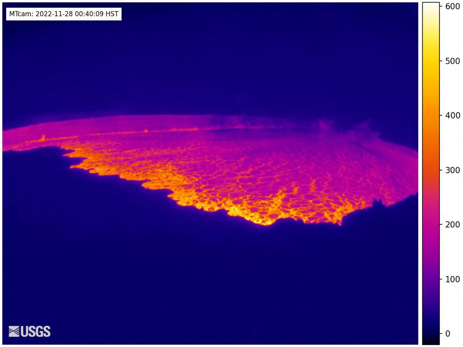
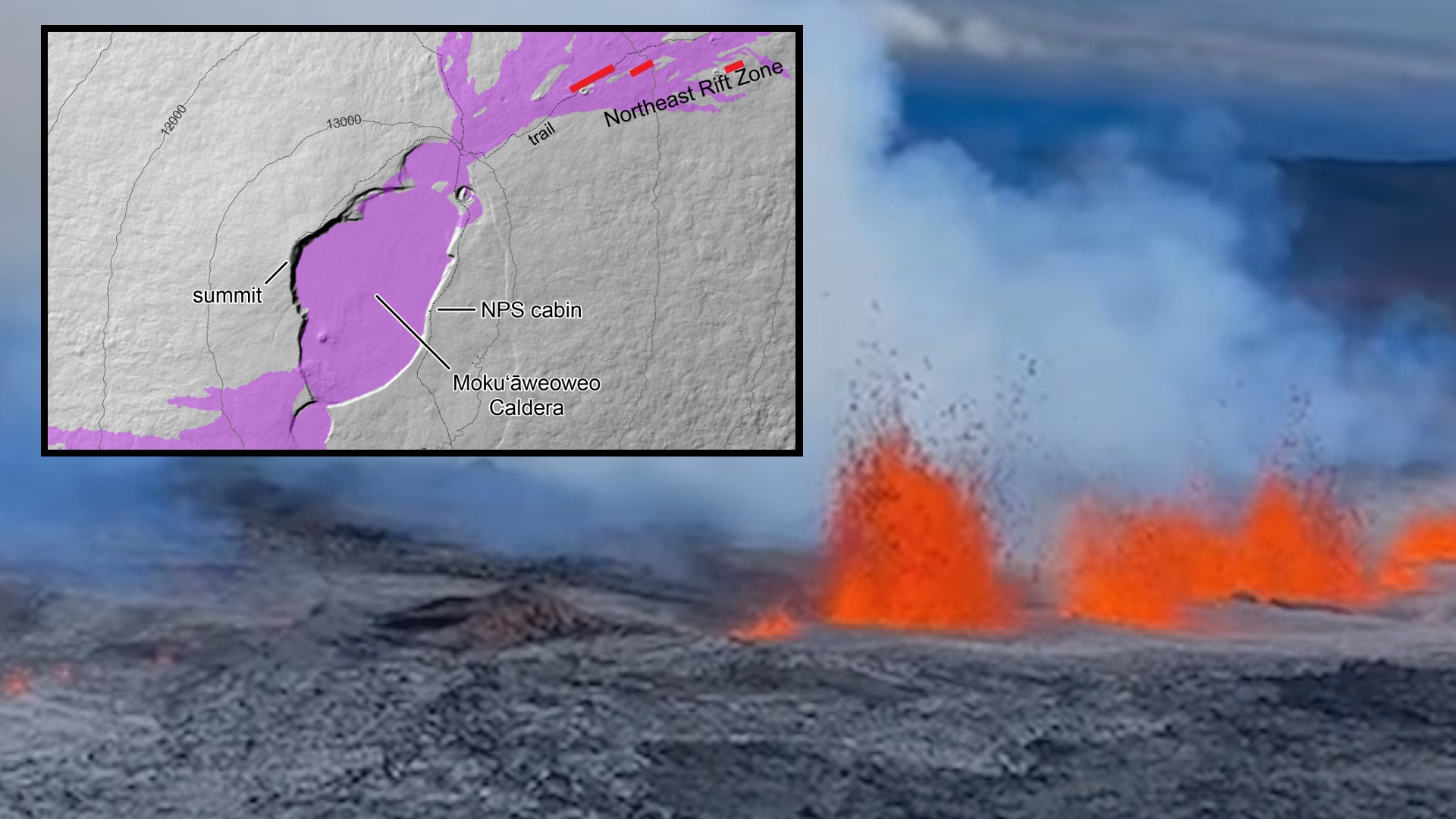
The earthquake activity this morning (vnet reported) at Mauna Loa was an indicator of the beginning of an eruption. On the LiveCam you can see that an eruption fissure has opened in the caldera and lava is flowing out. It is currently flooding the caldera floor.

The HVO reports that the eruption started around 23:30 HST (10.30 UCT). The activity is so far confined to the Moku'āweoweo summit caldera and poses no danger to residents. Nevertheless, the alert status has been raised to "red". Volcanologists stress that the wind may blow volcanic gases and possibly fine ash and Pele's hair. Health authorities are in close contact with the HVO and close monitoring is being done to see if any health hazard develops for humans and animals. As early as October, residents were warned to prepare for evacuations if a volcanic eruption occurred at Mauna Loa. If cracks form on the volcano's flanks, then residents living near the volcano are in danger. Lava at Mauna Loa is usually thin and flows quickly.

The eruption started quite surprisingly now, as there was no major seismic crisis beforehand. Although seismicity and inflation had been elevated since September, both parameters had declined slightly in the last few days. Only when the fissure opened did a small swarm of earthquakes begin. A noticeable number of earthquakes had magnitudes greater than 2. The quakes were close to the surface. When I inspected the LiveCam this morning as part of my earthquake news, nothing had yet been seen.

Photos are being shared on social media showing a red illuminated night sky over the volcano. In these shots, it looks like an eruption fissure has also opened on the volcano's flank!

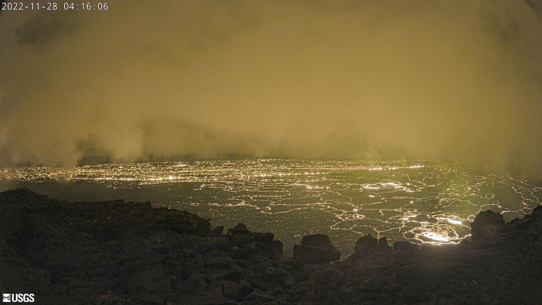
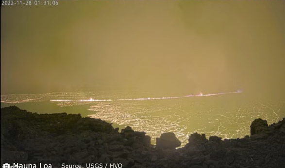
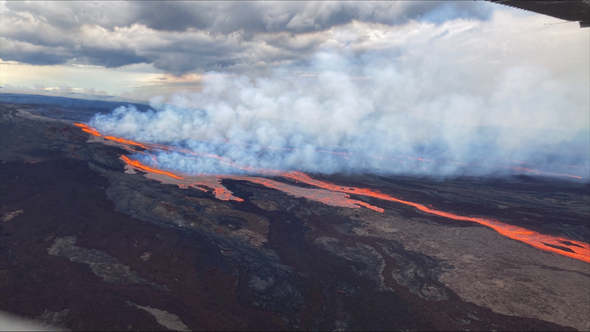
Update 17:00: Apparently fissures have now opened on the volcano's flank. Some sources speak of 3 fissures. One seems to be quite long. Lava could now reach inhabited areas and also flow into the ocean.


END OF ARTICLE


Mauna Loa on Hawaii: Eruption fissures on the flank
28 November 2022 • by Marc Szeglat

State: USA | Location: 19.47, -155.59 | Activity: Lava flow


maunaloa-bild.jpg

m9.jpg

M-6.jpg

Fissures on the northeast flank of Mauna Loa volcano

What the sparrows have been whistling for the last few hours has now been confirmed by HVO officials: Several fissures opened on the northeast drift. Lava flows are heading towards Mauna Loa Weather Observatory. There is no further official data so far. However, on the live graphs of the geophysical parameters one can see that the inclinometers jumped shortly before the eruption started and detected a very fast inflation of up to 100µrad. So a larger magma body must have risen. However, these are raw data that still have to be evaluated by volcanologists. The EMSC detected a good 70 quakes with magnitudes of 2 and above. Seismicity remains high and further fissure openings must be expected.

MOK-TILT-1wk.jpg


END OF ARTICLE


About Mauna Loa
by Marc Szeglat


Mauna Loa is not only the most powerful volcano in Hawaii, but also the largest active fire mountain on earth: if you measure it from the seabed, it is almost 9200 m high. This makes it tower over even Mount Everest. The overseas part of the volcano is an impressive 4170 m high. Its diameter is 120 km. Its mass is so enormous that the volcano is even denting the Pacific plate. It is only surpassed by the neighbouring volcano Mauna Kea by a few metres. However, Mauna Kea's volume and mass are smaller than Mauna Loa's.

Mauna Loa is a typical shield volcano that produces relatively thin tholeiitic basalt lava. Two nested calderas spread out at its summit. The outer one measures 6x8 km, the inner one 3x5 km. The latter was formed only about 600 years ago after a major eruption. Two rift systems emanate from the summit crater Mokuaweoweo, along which magma rises.

For an active volcano, Mauna Loa is comparatively old: it began growing from the seabed a good 1,000,000 years ago. In this first stage as a seamount, it produced pillow lava and hyaloclastite. This is the typical pyroclastics of submarine volcanoes. Hyaloclastite contains a lot of volcanic glass and is formed in the absence of oxygen. Mauna Loa reached the water surface 400,000 years ago and thus entered its 2nd life cycle as a shield volcano of a hot spot.

Since the islands of Hawaii were settled relatively late, only a few records of volcanic eruptions exist. One of the first descriptions dates from 1832, and 33 eruptions are known since then. In the 19th century, an eruption occurred that lasted a year and produced 4.1 cubic kilometres of lava. The largest known eruption of Mauna Loa began in 1950, opening a 20 km fissure along one of the rift systems. Lava fountains fed lava flows that reached the sea within 4 hours. The fastest lava flow reached a speed of 48 km per hour. Another series of eruptions occurred in 1975. The last eruption so far took place in 1984.

Years earlier, inflation had already begun and the volcano began to swell. In spring, swarm quakes were recorded: the strongest single quake had a magnitude of 6.6. On 24 March, tremors set in and one day later the eruption began. A fissure opened in the southwest of the summit caldera and a lava fountain generated lava flows that flooded the bottom of the caldera. A few hours later, the northeastern rift zone opened 650 m below the summit. Lava flows headed towards the island's capital, but stopped at the outskirts. The eruption ended after a little more than 3 weeks.

Since then, it has been relatively quiet at Mauna Loa. However, volcanologists have observed slight inflation in recent years. Since spring 2015, seismicity has been increasing somewhat. A new eruption cycle of the volcano could start soon.

END OF ARTICLE
 
Mauna Loa, Hawai'i
28 Nov 2022

There are not so many images people have posted. Here are two, from afar. Overall, Mauna Loa is so extremely mighty that you don't really get a grip over the size of that volcano. For example: When we lived at Ocean View in the southeast, and you look up towards the volcano; all you can see is a gentle rise into infinity. You never see the top of the volcano - it is that large.

Mauna-loa-from-liliuokalani.jpg
Matthew Liano, Kailua Kona, Hawai'i Big Island

Matthew-Liano,-Kailua-Kona-Big-Island.jpg
Matthew Liano, Kailua-Kona, Hawai'i


Flow Chart from earlier eruptions

Notice how extremely fast the lava from Mauna Loa can be - sometimes it took only 3.5+ hours [in year 1950] to reach the ocean (South Kona, Ocean View etc) in the Red Zone

Vwatch-map-2021-V8-blind_KM_edited_0.jpg
 
News from Hawai'i

If you like you follow the news from Hawai'i - here is one source which covers everything revolving Hawai'i


Here a photo from USGS when the eruption started:

USGS: “Aerial photos taken at 7:15 AM local time (HST) from Civil Air Patrol flight. Northeast rift zone eruption of Mauna Loa.”

2022-11-28-mauna-loa-NE-03.jpg


Below in the link

you find an overview from the mighty Moku‘āweoweo caldera, before the eruption, on 28 Oct 2022, published 3 Nov 2022, with images and video.


202210281006_MULLIKEN_8651.JPG
 
Mauna Loa, Hawai'i
28 Nov 2022

317556341_517001950474278_2159069949904990544_n.jpg
USGS image taken November 28, 2022 around 10:00 am local time in Mauna Loa's Northeast Rift Zone by M. Zoeller.

USGS

HVO field crews are at the summit of Mauna Loa to make observations and collect information that will be used to create and update lava flow maps and inform hazard analysis.

To recap, at approximately 11:30 p.m. (local time) on November 27, 2022, an eruption began in Moku‘āweoweo, the summit caldera of Mauna Loa, inside Hawai‘i Volcanoes National Park. By 7:30 am on November 28, the eruption had migrated from the summit to the Northeast Rift Zone where fissures now feed several lava flows. The lava flows are not threatening any downslope communities and all indications are that the eruption will remain in the Northeast Rift Zone.

Stay up-to-date:
• Mauna Loa eruption updates from the USGS Hawaiian Volcano Observatory: https://www.usgs.gov/volcanoes/mauna-loa
• Alerts from the Hawaii County Civil Defense Agency: https://hawaii-county-volcano-hazards-hawaiicountygis.hub...
• Hawai‘i Volcanoes National Park road closures: Hawaiʻi Volcanoes National Park (U.S. National Park Service)
• Vog information: Vog Information Dashboard | IVHHN
 
Mauna Loa, Hawai'i
28-29 Nov 2022

2022-11-28-maunaloa-Saddle.jpg
Kilauea and Mauna Loa erupt together. Photo taken at 6:06 a.m. Monday, November 28 from Kūpinaʻi Pali in Hawaiʻi Volcanoes National Park. (NPS Photo/J.Ibasan)


2022-11-28-maunaloa-HVNP-01.jpg
Mauna Loa eruption seen from Daniel K. Inouye Highway / Saddle Road (NPS Photo/Janice Wei)
Note: I think to the left you see the Kilauea volcano withe the active lava lake inside the Halema'uma'u crater


2022-11-28-maunaloa-UPDATE-3-pic-2.jpg
USGS: “Aerial view of Mauna Loa summit with Lua Hou in the foreground followed by Lua Hohonu, South Pit, and Mokuʻāweoweo summit caldera. A small dusting of snow covers the ground east of the summit. The steaming fissure was active during the beginning of the eruption, but this morning the lava in the summit caldera had already cooled to a black color. The white plume in the background is rising from the fissures in the Northeast Rift Zone.” (USGS photo J. Schmith)


2022-11-28-maunaloa-UPDATE-3-pic-3.jpg
Aerial photo of a fissure and lava flows on Mauna Loa’s Northeast Rift Zone at approximately 9:30 a.m. HST on November 28, 2022. The photo view is to the NW, with Mauna Kea on the right hand side of the image. USGS photo by K. Lynn.


HAWAIʻI ISLAND
Currently, lava from the eruption is "heading in the best possible direction, which is away from our communities", officials say.


(BIVN) – New video of the eruption high up on Mauna Loa is being shared tonight across social media. The current direction of the lava flows, which shifted this morning the Northeast Rift Zone, indicates to emergency officials that there is no imminent threat to the community at this time.

“Our team is on full alert and is prepared to respond to whatever situation may arise as a result of the Mauna Loa eruption,” said Mayor Mitch Roth in a Monday news release. “That said, we’ve been told that the lava is heading in the best possible direction, which is away from our communities. We’ll continue to monitor the situation and will be providing updates to the community regularly. Until then, we thank our State and County partners, departments, and agencies for their quick action and attention to every detail.”

The current Mauna Loa Volcano Alert Level remains at WARNING / RED. According to the USGS HVO just before 5 p.m. HST:

The eruption of Mauna Loa continues on the Northeast Rift Zone. Three fissures erupted and as of 1:30 PM, only the lowest of the three fissures was active. Estimates of the tallest fountain heights are between 100–200 ft (30 – 60 m), but most are a few yards (meters) tall. The fissures sent lava flows to the northeast and parallel to the rift zone. Lava flows from the two higher fissures moved downslope but stalled about 11 miles (18 km) from Saddle Road. Fissure 3 is currently feeding lava flows moving east parallel to the Northeast Rift Zone. These remain at above 10,000 feet elevation and over 10 miles (16 km) away from Saddle Road. We do not expect upper fissures to reactivate. However, additional fissures could open along the Northeast Rift Zone below the current location, and lava flows can continue to travel downslope.
There is no active lava within Moku’āweoweo caldera, and there is no lava erupting from the Southwest Rift Zone. We do not expect any eruptive activity outside the Northeast Rift Zone. No property is at risk currently. There is a visible gas plume from the erupting fissure fountains and lava flows, with the plume primarily being blown to the Northwest.

The communities in South Kona near and around the Southwestern Rift Zone appear to be in the clear, as long as the eruption follows the patterns that have been observed historically.

Ken Hon, the Scientist-in-charge of the US Geological Survey Hawaiian Volcano Observatory, spoke at a virtual media briefing on Monday:

“We know in any historic precedence that there has never been a eruption of Mauna Loa that activated both rift zones at the same time or during the same eruption. So we presume at this point that all of the future activity is going to be on the Northeast Rift Zone of Mauna Loa, and not on the Southwest Rift Zone. So those residents in that area do not have to worry about lava flows.
Currently, right now, because the Northeast Rift Zone empties into the Saddle Area, there’s no real habitation up there. Pōhakaloa Training Area, their facilities are outside of where we consider any initial lava flows to go, and the only real facility up there is the Mauna Loa weather Observatory, which is not directly threatened, but there’s a chance its road could perhaps be cut by these lava flows.”

2022-11-28-maunaloa-UPDATE-3-pic-4.jpg
USGS: “An eruption of Mauna Loa volcano started at 11:30 p.m. on Sunday, November 27, 2022. Initial fissures covered the floor of Moku‘āweoweo caldera with new lava, but this area was mostly inactive by the time HVO field crews arrived after sunrise on Monday morning. Other fissures spilled lava to the southwest of the summit region, but this area was also inactive by that time.

HVO field crews observed active lava flowing to the north of the upper Northeast Rift Zone, in the direction of the access road to the NOAA Mauna Loa Observatory, but not reaching it. New fissures opened in a northeasterly direction along the rift throughout the day. By the time HVO field crews left the area (due to adverse weather) at 1:30 p.m., most of the eruptive activity was focused at a single fissure marked here in dark purple. This fissure was sending lava flows in multiple directions, but the most vigorous and farthest travelled was a set of three lobes moving to the northeast, marked here by red dots. Cloudy weather hampered mapping efforts on Monday; more complete lava flow maps are expected in the coming days.”


“In the long term: eventually, this kind of lava flow is very similar to what happened in 1984 and potentially could threaten populated areas around Hilo, but we’re looking at somewhere around a week before we expect lava to get anywhere near that direction. We’re hoping that it will parallel the 1984 eruption in becoming more viscous as time goes on, hitting flatter slopes around the Saddle that slow it down. And this actually prevented the lava from getting into Hilo, and historically this has been the case. Only a couple of eruptions have made it into the outskirts of what is current Hilo, so we’re hoping that this lava flow will.

It will be a big spectacular event. It occupies a fairly small proportion of the island and hopefully it will have relatively minor effect on the residents and visitors to the island.”
The Hawaiʻi Department of Health is also advising the public to be prepared for air quality impacts due to the Mauna Loa eruption. They say the eruption could cause vog conditions, ash in the air, and levels of sulfur dioxide to increase and fluctuate in various areas of the state.
 
El Salvador

The Chaparrastique volcano in
San Miguel has officially started an eruptive phase intensity 1. Authorities have issued a green alert for the municipalities of San Jorge, Chinameca and San Rafael Oriente de San Miguel. The safety radius was extended to 6 km from the crater....
---
The volcano increased its activity since last November 15. Since then, 176 explosions have been registered, with an average of 14 per day. The maximum height that the emissions have reached is 1,100 meters, according to PROCIVIL.


Mauna Loa, Hawai'i
1 Dec 2022

I gathered a couple of images from the USGS site - and here seems to be the general (extensive) photo library they have, fairly regularly updated during the ongoing eruption of mighty Mauna Loa.


The latest published lava flow chart

It appears that the lava stream is closing in to the Saddle Road, which is the major road between west and east on Big Island Hawai'i - albeit the lands there are flat, so perhaps the larger lava stream might move eastwards ?

MicrosoftTeams-image-(13)_0.jpg


2022-11-30.jpg
Fissure 3 of the Northeast Rift Zone Mauna Loa eruption with a plume of volcanic gases and fine volcanic ash and Pele's hair being wafted in a near vertical plume. Taken at about 7:15 AM on November 30, 2022.


MicrosoftTeams-image-(4)_2.png.jpg
Aerial photograph of the dominant fissure 3 erupting on the Northeast Rift Zone of Mauna Loa, taken at approximately 8 a.m. HST November 29, 2022. Fissure 3 fountains were up to 25 m (82 ft) this morning and the vent was feeding the main lava flow to the northeast. USGS photo by M. Patrick.


multimediaFile-3722.jpg
This image, taken during a helicopter overflight on the afternoon of November 29, shows the advancing flow front from Mauna Loa. This flow was erupted from a vent high up on the Northeast Rift Zone and is flowing to the north. USGS image by L. Gallant.


DSC_1830_0.JPG
DSC_1748_0.JPG
Aerial photo captured during an overflight of the Northeast Rift Zone eruption of Mauna Loa at approximately 5-6:30 p.m. HST on November 28, 2022. This photo is looking at the line of fissure vents erupting above 10,000 ft elevation on the Northeast Rift Zone of Mauna Loa. Lava flows being generated from the line of fissure vents are on the northeast flank of Mauna Loa. Image courtesy of Civil Air Patrol.


1880-81 Eruption

image1-1439.jpg
The 1880-1881 eruption of Mauna Loa produced lava flows that came within 1.7 km (1.1 mi) of the Hilo Bay shoreline. This painting by Charles Furneaux, "Night View 1880–1881, Eruption from Hilo Bay," illustrates the first two flows as they would have been in November 1880. In reality, however, both flows would not have been visible from this vantage.

The story of this eruption can be read in great detail in this new USGS publication [pdf file 73 MB) with plenty of illustrations, maps and paintings - really well made and interesting who likes Hawai'i, and the interactions/observations between humans and volcanism on this fascinating island.
 
Mauna Loa, Hawai'i
1-2 Dec 2022

The latest summary from HVO about the Mauna Loa eruption.

IMG_3768.JPG

IMG_5499.jpg
View of fissure 3 on Mauna Loa's Northeast Rift Zone erupting during the morning of December 1, 2022. Fissure 3 continues to be the dominant of two erupting fissures on Mauna Loa's Northeast Rift Zone.

HAWAIIAN VOLCANO OBSERVATORY DAILY UPDATE
U.S. Geological Survey • Thursday, December 1, 2022, 9:09 AM HST (Thursday, December 1, 2022, 19:09 UTC)

MAUNA LOA (VNUM #332020)
19°28'30" N 155°36'29" W, Summit Elevation 13681 ft (4170 m)
Current Volcano Alert Level: WARNING
Current Aviation Color Code: RED


Activity Summary:

The Northeast Rift Zone eruption of Mauna Loa continues, with two active fissures feeding lava flows downslope. Fissure 3 remains the dominant source of the largest lava flow. The fissure 3 lava flows are traveling to the north toward the Daniel K. Inouye Highway (Saddle Road) but have reached relatively flatter ground and have slowed down significantly as expected. Advance of the largest flow slowed over the past 24 hours to a rate of 0.025 miles per hour (40 meters per hour).

As of 7 a.m. HST today, the flow front is about 3.4 miles (5.4 km) from the Daniel K. Inouye Highway (Saddle Road). Advance rates may be highly variable over the coming days and weeks due to the way lava is emplaced on flat ground. At the rate observed over the past 24 hours, the earliest the lava flow might be expected to reach the Daniel K. Inouye Highway (Saddle Road) is one week. However, there are many variables at play and both the direction and timing of flow advance are fluid and are expected to change over periods of hours to days.

Fissure 4 is still active with lava flows moving toward the northeast at a rate of 0.04 miles per hour (60 meters per hour). The northeast fissure 4 lava flow crossed the Mauna Loa Weather Observatory road overnight. A small lobe is moving to the east from fissure 4 at a slower rate than the main lobe. Volcanic gas plumes are lofting high and vertically into the atmosphere. Pele's hair (strands of volcanic glass) is falling in the Humu‘ula Saddle area.

Our seismic monitoring detects tremor (high rates of earthquakes) in the location of the currently active fissures. This indicates that magma is still being supplied, and activity is likely to continue as long as we see this signal.

There is no active lava within Moku'āweoweo caldera, and the Southwest Rift Zone is not erupting. We do not expect any eruptive activity outside the Northeast Rift Zone. No property is at risk currently.
 
Mauna Loa, Hawai'i
1-2 Dec 2022

Lots of material - especially from one photographer ("Paradise Helicopters") - whose images are simply amazing, having a photographical eye (e.g. not just documenting the lava flows, but putting them into truly beautiful compositions) Those I put in a second entry, by themselves.

First a video
Lavaflows from helicopter

In this spectacular video shot yesterday afternoon by Sky Makai we can see the active front of the main lava flow fed by the ongoing effusive eruption on the north-eastern flank of Mauna Loa, Hawaii. This is a type AA flow, i.e. characterised by a rough surface formed by numerous lava blocks, which is several metres thick and is advancing up the flanks of the volcano at a speed of only 40 metres per hour due to the almost flat topography of the area. Currently, the most advanced front of the flow is located at an altitude of 2,000 metres and is at least 5.2 kilometres from one of the island's main roads, Saddle Road.

Note: make sure to select HD quality, instead of SD.


Patrice-Zwenger_smaller.jpg
Patrice Zwenger i believe took this shot ?


The Lava Flow chart at Mauna Loa, from 1 Dec 2022

2022-12-01.jpg
 
Back
Top Bottom