Volcanoes Erupting All Over


Source

[#西之島 Voyage report] Volcanic gas ejected Nishinoshima .. You have to go south to see the crater, but you can't go because it's leeward. I managed to shoot the crater from the southwest today .. You will be overwhelmed by the huge crater over 400m. Check here for Nishinoshima! http://jamstec.go.jp/verc/j/mv/nish

RnkDVuzi
 
Mount Otake, a volcano on Suwanosejima, an island in southwestern Japan, erupted on Monday morning, the Japan Meteorological Agency said, rising the volcanic alert level from 2 to 3 on a scale of 5.

6 hours ago - 10:36

28 DEC, 2020
 
Along with what might be an uptick in earthquake activity, a new dome has been sighted at La Soufriére volcano in St Vincent, a volcano that's been considered quiescent for the past 41 years. And, although i haven't looked into it, it would appear that there may be something going on at Kilauea, Hawaii, with lava noted to be continuing to pour into a lava lake. I'm pretty sure i've seen a few Tweets regarding the activity at this volcano recently.
 
Last edited:
Along with what might be an uptick in earthquake activity, a new dome has been sighted at La Soufriére volcano i

Volcano - Saint Vincent and the Grenadines Set An "Orange Alert" After Magma Expulsion
Premiered 2 hours ago

December 31, 2020, ~ Explosion ~ Sakurajima Volcano, Japan ~ 17:14 JST #volcano #sakurajima #japan

Kilauea Update - Eruption Vigor Appears To Be Decreasing (Dec. 29, 2020)

Kīlauea Message Thu, 31 Dec 2020 18:05:31 HST: Kīlauea summit eruption within Halemaʻumaʻu crater continues. Gas emissions remain elevated & hazardous. HVO continues to closely monitor the situation but will post new status updates only in the event of changing conditions.
 
Sinabung volcano has erupted, spewing ash 3.6 kilometers into the sky.

BY: MARTIN - 5 Jan 2021

Posted by Teo Blašković on January 5, 2021


Activity of #Volcán#Popocatépetl at this time. Webcam #EnVivo 24/7
http://webcamsdemexico.com/webcam-popocatepetl-tlamacas since #Tlamacas ,#EdoMex . Via:#CENAPRED @CNPC_MX
The Volcanic Warning Stoplight is at #AmarilloFase2 . You are urged NOT to approach the volcano.
https://twitter.com/USGSVolcanoes

USGS Volcanoes Jan 9 2021
#Kilauea2021: helicopter overflight on Jan 7, captures visual & thermal imagery for updated #map of #Halemaumau. Dimensions of lava lake are 831 yd by 514 yd (69 acres). #Lava levees and cooler perimeter are visible on the right side of the #lavalake, in photo taken Jan 6.

Hawaii Kilauea Volcano Eruption Lava Lake Weekend Update 🌋- 1/10/2021

•Jan 11, 2021
This January 10th, 2021 Kilauea Volcano Eruptions update presentation video contains two of the latest USGS lava flow and aerial video with several additional improvements such as motion enlargements, sharpness increase, vibration reduction and additional sound effects enhanced videos. According to the USGS HVO Scientists, the lava lake is still rising it is around 194 m (636 ft) deep and has about 27 million cubic meters (36 million cubic yards). A newly installed instrument showed that the lake level rose about a meter (yard) since the start of the switch from deflationary to inflationary tilt yesterday evening. The most recent thermal map (Jan. 7) provided the perched lake dimensions as 760 by 470 m (830 by 540 yds) for a total area of 28 ha (69 acres) but only the western half was active. (https://www.usgs.gov/maps/december-30...). The lake is now perched about a meter (yard) above its narrow edges as measured Sunday morning (Jan. 3); overflows onto the narrow edge slowly elevated a low wall around the lake similar to the wall around an above-ground swimming pool. The media & data obtained from University of Hawaii USGS and Google Earth with some of the details from; USGS at https://www.usgs.gov/volcanoes/kilaue..., earthquakes data and http://pgf.soest.hawaii.edu/Kilauea_i....

Compilation 2020
Jan 4, 2021 / 2:45 i ameztoy
Imagery published in 2020. Sentienl-2, Landsat-8, SNPP-VIIRS, MODIS Terra & Aqua, Himawari-8, GOES,... satellites
 
Last edited:
The lava dome at Soufriere volcano continues to grow, and the alert level remains at Orange.

BY: MARTIN - 15 Jan 2021

Posted by Teo Blašković on January 15, 2021

Published on 15.1.2021 (2:59)
 

Popocatépetl en este día hasta las 18:00 hrs...Jan 16, 2021

Indonesia

CSN located 7,826 earthquakes in Chile during 2020. Of the total number of events processed by the National Seismological Center, 302 were reported as perceived and 73 had a magnitude equal to or greater than 5.0. Check out the full report here:https://csn.uchile.cl/csn-localizo-7


#volcan#volcano#Merapi A probably larger portion of the dome came loose that night-> pyroclastic flow / A bigger portion of the new lava dome seems to have collapsed tonight-> Pyroclastic Density Current
 

Volcano Daily Report
Posted on 2021-01-17 06:29:00 (43 minutes ago) by Washington VAAC (Sangay)
Posted on 2021-01-17 06:09:00 (an hour ago) by Washington VAAC (Popocatepetl)
Posted on 2021-01-17 05:50:00 (an hour ago) by Tokyo VAAC (Klyuchevskoy)
Volcanic Ash AT 20210117/0120Z Flight Level 200 Extended Northeast Observed Volcanic Ash Date and Time 17/0120Z
Posted on 2021-01-17 01:54:00 (5 hours ago) by Tokyo VAAC (Klyuchevskoy)
Posted on 2021-01-16 17:50:00 (13 hours ago) by Darwin VAAC (Sinabung)
Continued:


IMAGE 2021-01-19 15:13:50.jpg

Mama Etna in Sicily, in full swing...

Yesterday, 18 Jan 2021, with another Paroxysm which ended before midnight. I do not know who took the first photo - but it's just amazing. My husband send it to me while out in town (here in Stockholm)

He says this photo is taken from Giarre (east coast of Sicily).

The photo below was taken by Massimo Lo Giudice (also yesterday) which looks to me (assuming) like the New Southeast crater.


IMAGE 2021-01-19 15:13:54.jpg
 
Line 1: #volcan#volcano#Klyuchevskoy Since last night, lava has been flowing again in the Apakontchich ravine (south-eastern slope). Since last night the lava flows in the Apakontchich Gully (South-East Flanck) again
Line 2: The situation seen from space, via @sentinel_hub @esa @CopernicusEU

active-volcano-map.jpg


The Watchers report that there's another quake swarm in the Canary islands, and linked in the comments is a paper detailing the impact that a significant eruption could have by way of a tsunami on the Americas. Maybe one to keep an eye on, although as of yet it doesn't seem as though there's cause for any alarm, although it is notable that last year the quake swarms went from one a year to five in one year:

Earthquake swarm under Cumbre Vieja volcano, Canary Islands​


Posted by Teo Blašković on February 1, 2021 at 11:28 UTC (55 minutes ago)


Earthquake swarm under Cumbre Vieja volcano, Canary Islands


A new earthquake swarm started under the Cumbre Vieja volcano on La Palma island, Spain's Canary Islands on January 31, 2021. This is the second swarm of earthquakes in this area since December 23, 2020, and 8th since 2017.

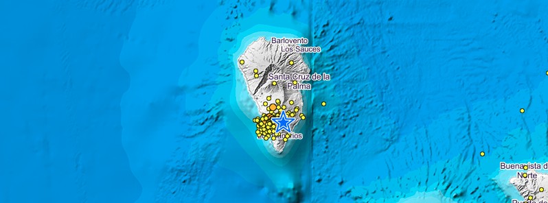
Of the numerous seismic events detected since the swarm started at 04:11 UTC on January 31 to 17:59 UTC on the same day, 96 of them have been located by the Canary Island Seismic Network in La Palma.

The quakes are taking place on the western slope of the volcano at depths between 15 and 20 km (9 - 12 miles).
The maximum observed magnitude was 1.8.
cubre-vieja-earthquake-swarm-january-31-2021-bg.jpg

The figure shows the epicenters of the new earthquake swarm in red color and seismicity during the last 3 years in black
. Credit: INVOLCAN

This new seismic swarm poses no danger to residents and visitors to La Palma given the small magnitudes and depths of earthquakes, INVOLCAN said.

The alert level remains at GREEN - continue your activities normally, know your physical environment and learn what to do in case of a change in volcanic activity.

In the short and medium terms, no significant change in volcanic activity is expected.

There have been 8 seismic swarms under the volcano since 2017 -- 1 in 2017, 1 in 2018, 5 in 2020, and 1 in 2021.

There have been no significant horizontal and vertical shifts detected through the Canary GPS Network in La Palma in recent years; therefore, no deformation of the ground has been observed at the volcano.

The occurrence of events of this type in an active volcanic zone is within normality and does not present any risk to the population, IGN experts said.

Regarding the geochemical program for monitoring the volcanic activity of Cumbre Vieja, it is worth highlighting the observation of significant changes in the diffuse emission of hydrogen into the atmosphere by the Cumbre Vieja volcano linked to recent seismic swarms, as well as an increasing trend in the diffuse flux of carbon dioxide at the LP04 geochemical station.

earthquakes-la-palma-90-days-to-february-1-2021-bg.jpg


Earthquakes detected at La Palma, Canary Islands, Spain in 90 days to February 1, 2021. Credit: IGN

Geological summary​

The 47-km-long (29 miles) wedge-shaped island of La Palma, the NW-most of the Canary Islands, is composed of two large volcanic centers. The older northern one is cut by the massive steep-walled Caldera Taburiente, one of several massive collapse scarps produced by edifice failure to the SW.


The younger Cumbre Vieja, the southern volcano, is one of the most active in the Canaries.

The elongated volcano dates back to about 125 000 years ago and is oriented N-S. Eruptions during the past 7 000 years have originated from the abundant cinder cones and craters along the axis of Cumbre Vieja, producing fissure-fed lava flows that descend steeply to the sea.

Historical eruptions at La Palma, recorded since the 15th century, have produced mild explosive activity and lava flows that damaged populated areas.
The southern tip of the island is mantled by a broad lava field produced during the 1677-1678 eruption. Lava flows also reached the sea in 1585, 1646, 1712, 1949, and 1971. (GVP)

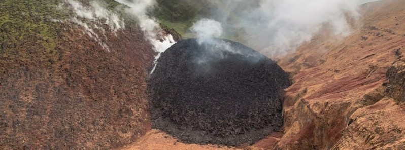
Featured image credit: IGN

An extract from the paper:


Cumbre Vieja Volcano -- Potential collapse and tsunami at La Palma, Canary Islands


Steven N. WardInstitute of Geophysics and Planetary Physics, University of California, Santa Cruz California, USA
Simon DayBenfield Greig Hazard Research Centre, Department of Geological Sciences, University College, London, UK

Abstract. Geological evidence suggests that during a future eruption, Cumbre Vieja Volcano on the Island of La Palmamay experience a catastrophic failure of its west flank, drop-ping 150 to 500 km3 of rock into the sea. Using a geologically reasonable estimate of landslide motion, we model tsunami waves produced by such a collapse. Waves generated by the run-out of a 500 km3 (150 km3) slide block at 100 m/s couldtransit the entire Atlantic Basin and arrive on the coasts of theAmericas with 10-25 m (3-8 m) height.
1612353255145.png
View attachment 42295
 
Last edited:
Back
Top Bottom