Sitting under a historic storm in the NE, first time in history that the entire state of NJ is put under a blizzard warning. Just yesterday the last bits of the last storm had finally melted away and we're getting a lot of brand new snow on the ground.
You are using an out of date browser. It may not display this or other websites correctly.
You should upgrade or use an alternative browser.
You should upgrade or use an alternative browser.
What's the weather where you are?
- Thread starter Maia
- Start date
Well, winter is leaving us in central Mexico; the days are slowly feeling warmer. My peach tree is already beginning to bloom. It has the typical small pink flowers. Also the jacarandas (purple/lilac-flowered trees) will soon start to bloom in Mexico City.

The Peach Tree (Valley of Toluca)

The Jacaranda tree in Mexico City (file photo)
The Peach Tree (Valley of Toluca)
The Jacaranda tree in Mexico City (file photo)
palestine
The Living Force
Here in Geneva Switzerland it has been raining for almost three weeks non-stop; every day. Only since last two days, do we have the sun back. Lawns were becoming mud battlefields and I have some moss growing on my plants.
EDITED: was thinking about the Inter Tropical Zone shifting North
EDITED: was thinking about the Inter Tropical Zone shifting North
Also the jacarandas (purple/lilac-flowered trees) will soon start to bloom in Mexico City.
I love jarcarandas. The tree shape is so interesting and the flowers are gorgeous. It was a bummer to find out they won't grow in zone 7.

I love jarcarandas. The tree shape is so interesting and the flowers are gorgeous. It was a bummer to find out they won't grow in zone 7.
The jacaranda trees that adorn Mexico City originally come from South America (mainly Brazil, Paraguay, and Argentina). They were introduced and planted en masse in the capital in the 1920s by Japanese gardener and immigrant Tatsugoro Matsumoto, who suggested their use as an alternative to Japanese cherry trees, as Mexico's temperate climate was perfect for them.
And it was a complete success: the jacaranda trees adapted to the temperate climate and soil of Mexico City, allowing them to spread along avenues such as Reforma and Insurgentes.

And it was a complete success: the jacaranda trees adapted to the temperate climate and soil of Mexico City, allowing them to spread along avenues such as Reforma and Insurgentes.


The weather has been a bit extreme here lately, last week it rained every day, almost all day long, and there were even flood warnings in my area, southwestern Warren County, OH., —fortunately, not in my neighborhood.
And starting at least last Thursday, there was a high-wind warning in my area, although it affected the entire state, winds similar to those of a Category 1 hurricane; some areas lost power, but fortunately not in my neighborhood.
Yesterday, the temperature dropped from 20°C at night to 2°C now, with a chance of snow showers this afternoon.
Today, Wednesday, April 1st

 www.facebook.com
Overcast weather, with heavier rainfall in the Pyrenees.
Across much of western France, the weather is gloomy. From the English Channel and Hauts-de-France to the Pyrenees, cloud cover remains dense from morning to evening, with a few showers from Brittany and Lower
Normandy to the Pays de la Loire, and more frequent and sometimes heavy rain elsewhere.
In the Pyrenees, precipitation will intensify and accumulate throughout the day, with significant snowfall above 1200m, and even 1400m in the west during the afternoon.
Significant accumulations are expected, particularly in Ariège. From the Grand Est to Bourgogne-Franche-Comté and Rhône-Alpes, the sky is also very cloudy in the morning, but precipitation is infrequent and light, with some snow above 600 to 700m.
Showers remain possible in the afternoon, turning to snow above 700 to 800 meters, but the clouds will break up, giving way to increasingly sunny spells as the day progresses.
In the Mediterranean regions, the weather will remain dry and sunny from Languedoc to Provence-Alpes-Côte d'Azur (PACA), more mixed elsewhere, but the north to northwest wind will remain quite strong, with gusts of up to 80 to 90 km/h for the Mistral and Tramontane winds.
In Corsica, after a sunny morning, showers will develop during the afternoon, and overcast and rainy conditions will set in during the evening. As for temperatures, minimums will range from 0 to +4 degrees Celsius, locally as low as -1 degree Celsius from the Grand Est region to Auvergne-Rhône-Alpes, northern Occitanie, and eastern PACA, and from 3 to 8 degrees Celsius elsewhere, locally reaching 8 to 10 degrees Celsius near the Mediterranean coast. Maximum temperatures will range from 9 to 14 degrees across a large northeastern quarter up to the Massif Central and the Alps, from 12 to 17 degrees elsewhere, locally reaching 18 degrees near the Mediterranean.
WEATHER WARNING FRANCE 65000 Prefecture
Avalanches
Flooding
The Next Few Days
En langue française
Météo Pyrénées | Mérens-lès-Vals
Météo Pyrénées, Mérens-lès-Vals. 367,205 likes · 46,943 talking about this · 20 were here. Actualité météo, prévision, enneigement, avalanche, infos vent et risque orageux dans les Pyrénées
www.facebook.com
On Wednesday, there is a high risk of avalanches, accompanied by heavy snowfall across the eastern Pyrenees. Fresh snow accumulations could exceed 50 cm above 1,800 meters.The Mistral and Tramontane winds are subsiding but remain strong, with gusts reaching 80 km/h. meteofrance.com/actualites-e...clement__rosay (Alps)
Overcast weather, with heavier rainfall in the Pyrenees.
Across much of western France, the weather is gloomy. From the English Channel and Hauts-de-France to the Pyrenees, cloud cover remains dense from morning to evening, with a few showers from Brittany and Lower
Normandy to the Pays de la Loire, and more frequent and sometimes heavy rain elsewhere.
In the Pyrenees, precipitation will intensify and accumulate throughout the day, with significant snowfall above 1200m, and even 1400m in the west during the afternoon.
Significant accumulations are expected, particularly in Ariège. From the Grand Est to Bourgogne-Franche-Comté and Rhône-Alpes, the sky is also very cloudy in the morning, but precipitation is infrequent and light, with some snow above 600 to 700m.
Showers remain possible in the afternoon, turning to snow above 700 to 800 meters, but the clouds will break up, giving way to increasingly sunny spells as the day progresses.
In the Mediterranean regions, the weather will remain dry and sunny from Languedoc to Provence-Alpes-Côte d'Azur (PACA), more mixed elsewhere, but the north to northwest wind will remain quite strong, with gusts of up to 80 to 90 km/h for the Mistral and Tramontane winds.
In Corsica, after a sunny morning, showers will develop during the afternoon, and overcast and rainy conditions will set in during the evening. As for temperatures, minimums will range from 0 to +4 degrees Celsius, locally as low as -1 degree Celsius from the Grand Est region to Auvergne-Rhône-Alpes, northern Occitanie, and eastern PACA, and from 3 to 8 degrees Celsius elsewhere, locally reaching 8 to 10 degrees Celsius near the Mediterranean coast. Maximum temperatures will range from 9 to 14 degrees across a large northeastern quarter up to the Massif Central and the Alps, from 12 to 17 degrees elsewhere, locally reaching 18 degrees near the Mediterranean.
WEATHER WARNING FRANCE 65000 Prefecture
Avalanches
Flooding
The Next Few Days
En langue française
It seems that spring has decided to skip over much of Mexico. The rainy season in Mexico, which officially begins in May, has arrived early, and low temperatures continue to be recorded. The Popocatepetl and Nevado de Toluca volcanoes are now covered in snow. According to "Meteorología México", this phenomenon is due to the arrival of a cold vortex.
Snow in the Middle of Spring

Due to recent weather conditions, snowfall has been reported in the #Popocatepetl and Paso de Cortés areas, treating us to an incredible sight this Tuesday, March 31.
#Morelos
Persistent drought conditions in the SE US.

Drought Status Update for the Southeast | April 16, 2026 | Drought.gov
- Moderate to Exceptional Drought (D1-D4) conditions cover 96.83% of the Southeast, and Severe to Exceptional Drought (D2-D4) conditions cover 81.75% of the region. This is the largest area of drought (D1-D4) and of Severe Drought or worse (D2-D4) for the Southeast since the U.S. Drought Monitor started in 2000.
- The entire Southeast has precipitation deficits dating back to July 2025. For most of the region, precipitation deficits range from 8.00 to 16.00 inches over the past nine months.
- Georgia, North Carolina, and South Carolina have experienced record dry conditions for September 2025-March 2026, with records dating back to 1895. September–March was the second driest for Alabama, third driest for Florida, ninth driest for Tennessee, and tenth driest for Virginia.
- ...
- For the next three months, conditions may improve in some areas if a consistent, wetter pattern sets up. However, current moisture deficits do not put the region in a good situation as temperatures continue to increase and the rainfall pattern switches to summer convection, leading to more localized and inconsistent rainfall.
Here is the greater US map from the April 16 report.

Latest Seasonal Assessment - Extensive drought conditions continue across much of the nation, with over 60-percent of the contiguous United States currently experiencing drought conditions as of the April 7 US Drought Monitor. During the last month, widespread drought expansion and intensification occurred across the West, the central US, and the Southeast south of the Ohio River, as dry conditions and above-normal temperatures combined with increasing Spring evapotranspiration rates to rapidly dry soils and reduce streamflow levels. In contrast, several rounds of heavy precipitation eased drought across much of the Ohio Valley and Great Lakes region. A potent Kona Low brought flooding rainfall and eased drought conditions across Hawaii, while Alaska, Puerto Rico, and the US Virgin Islands remain drought free.
Magnolia
Jedi Master
In northeast US, there is deliberate understatement of the cold temperatures this spring.
For example, this week alone, wunderground.com states:
- sustained high temp for the day = 58 degrees. In fact, the high was 53, and only for an hour.
- the low temp at night = 34. In fact, it was 23.
- the current temp this morning is 42. In fact, it is 34, and the sun is already up.
Almost every day plays out like this. The only time it hit the mark was when the temperatures were abnormally high (e.g., one day, a few weeks ago, the temp was 78 for a few hours. They called that one right).
I have a locked-in oil price for the winter. The fellow refilled the tank last week and noted that (without the price lock) it would cost $5.95 a gallon for heating oil this week. That would cost $3,600 to run the heat for just 2 hours in the morning and 2 hours at night for 5 months; barely enough to keep the pipes from freezing.
Re spring gardening: I have noticed that the seeds I purchased and planted are doing very poorly. However, any seeds I saved from last year's garden, are surviving the cold rather well. They are better adjusted to this climate (and soil).
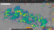
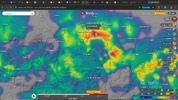
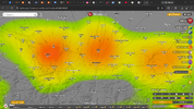
Mother Nature just opened a can of Wupp-ass in the Region of Occitanie with some of the darkest clouds I've seen since my return in Feb.
The system was accompanied by mild lightning and long, rolling thunder.
Estimates of the sudden deluge of precipitation were 31.6/h mm.
I know it seems mild, but it was the system's intensity that peaked with Shock and Awe and lasted about 30 minutes.
Telle est la vie, sur la grande bille bleue.
The system was accompanied by mild lightning and long, rolling thunder.
Estimates of the sudden deluge of precipitation were 31.6/h mm.
I know it seems mild, but it was the system's intensity
that peaked with Shock and Awe and lasted about 30 minutes.Telle est la vie, sur la grande bille bleue.
Attachments
Last edited:
Trending content
-

-

-
Thread 'Coronavirus Pandemic: Apocalypse Now! Or exaggerated scare story?'
- wanderingthomas
Replies: 30K -