What's the weather where you are?

Gaby said:
First day of autumn near where I live:

_GranizadaenTeruel225614534_8a.jpg


A few people were hospitalized due to hypothermia after a man's car got flooded underneath a bridge by the copious amounts of water and hail that fell. Those who rescued him had to swim in iced water. Cold adaptation would have come in handy!

Wow :shock: My first thought was that these are perfect conditions for building a snowman but I'm not so sure I would be so happy to build one in September!

Where was this photo taken Gaby? I guess if this weather resulted in people being hospitalised due to hypothermia all that snow must have come as a big surprise.
 
Ant22 said:
Where was this photo taken Gaby? I guess if this weather resulted in people being hospitalised due to hypothermia all that snow must have come as a big surprise.

It was in North Eastern, Spain. Here is the news source:

https://es.sott.net/article/54837-Primer-dia-de-otono-una-gran-granizada-deja-4-personas-atendidas-por-hipotermia-y-provoca-caos-circulatorio-en-Teruel-Espana

It is not snow, it is hail. I slept through all that adventure because I went to bed early. I woke up very early and there was no electricity. I thought I heard a big thunder at mid-night, but it was only after 9 am that I realized that a switch went off due to the thunderstorm.

I live nearby in higher ground where it didn't hailed as much and thus, it didn't accumulated.
 
Gaby said:
Ant22 said:
Where was this photo taken Gaby? I guess if this weather resulted in people being hospitalised due to hypothermia all that snow must have come as a big surprise.

It was in North Eastern, Spain. Here is the news source:

https://es.sott.net/article/54837-Primer-dia-de-otono-una-gran-granizada-deja-4-personas-atendidas-por-hipotermia-y-provoca-caos-circulatorio-en-Teruel-Espana

It is not snow, it is hail. I slept through all that adventure because I went to bed early. I woke up very early and there was no electricity. I thought I heard a big thunder at mid-night, but it was only after 9 am that I realized that a switch went off due to the thunderstorm.

I live nearby in higher ground where it didn't hailed as much and thus, it didn't accumulated.


Gosh, Gaby I think you're lucky you were safe at home and you slept through all this rather than being out in town. Getting caught in this would have been a very painful experience!

I hope your electricity is back now. I'm glad you live in an area that wasn't affected as much and hopefully you won't have trouble getting to work because of the hail.

I found a video on YouTube that shows results of a hail storm in Northern Spain in 2014 (I don't understand the language though). Yet another evidence that global warming is fake :scared:


Very cold in Macedonia also. It is cloudy and rainy for a few days. Temperatures are about 10-12C during the day and 7-8 C during the night. We had to turn the heating on for the first time in September.
Forecasts for next few days are that the rain will stop and the daily temperatures will go higher but the night temperatures will go down to 2-3 C.
Last week the first snow fell on the highest mountain peaks.
 
The winter weather is further creeping in with a continued winter storm warning for parts of the Province of Alberta (Environment Canada):

Hazardous winter conditions are expected.

Heavy snow and gusty winds continue in southern Alberta tonight. Another 5 to 10 cm is expected this evening south of Calgary, with higher amounts of 20 cm in the Cypress Hills.

Snow and gusty winds will taper off slowly this evening through Okotoks and Brooks regions and overnight in the Lethbridge region. Snow along with gusty winds will linger into Tuesday morning in southeastern Alberta.

Surfaces such as highways, roads, walkways and parking lots may become difficult to navigate due to accumulating snow. Visibility may be suddenly reduced at times in heavy snow. Poor weather conditions may contribute to transportation delays.

This includes southern Saskatchewan. In the North, blizzard conditions are developing in the Nunavut area:

Blizzard conditions with poor visibility in snow and blowing snow are expected or occurring.

A low pressure system over northern Baffin Island will intensify and produce strong winds over the eastern Kitikmeot Tuesday into Wednesday. Blizzard conditions will develop in Gjoa Haven Tuesday morning as winds gusting to 70 km/h will combine with fresh snow to produce blowing snow. Winds will continue to increase with gusts to 90 km/h Tuesday night.

With more snow forecast Tuesday night, blizzard conditions may develop in Taloyoak and Kugaaruk and warnings will be issued if necessary.
 
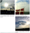
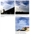
Hole-punch clouds were observed on Tuesday the 3rd of October 2017 over Northern Zealand which is north of Copenhagen in Denmark? It was reported by DMI:
_http://www.dmi.dk/nyheder/arkiv/nyheder-2017/oktober/fly-slog-hul-i-nordsjaellands-morgenhimmel/ said:
"The clouds - or the phenomenon - called a hole-punch cloud," says climatologist and DMI's cloud expert John Cappelen.
"The English name implies that someone or something has punched a hole in the cloud cover. I'm leaning most to a plane passed through the deck of altocumulus. It is the typical story of the kind of cloud holes," says senior climatologist.

Water, there is water, even when it ought to be ice
A hole occurs because cloud droplets in the altocumulus layer has been liquid water, but hypothermic. They have had a temperature below 0°C without being frozen to ice.
"The interference from a plane provokes freezing of the supercooled cloud droplets. The drops suddenly changed phase from a liquid to a solid; from water to ice. Ice crystals then sprinkled out of the cloud, have formed a featherlike ice cloud and left a gap," explains John Cappelen.
The feather cloud in the middle is actually the falling snow also called virga or fall stripes.
On the basis of the time stamps on the photos, DMI has received Tuesday morning, it is most likely that there have been (at least) three hole-punch-clouds on the game. They were then moved from the southwest to the northeast by the relatively strong wind.
The DMI article refers to an article:
_http://science.sciencemag.org/content/333/6038/77 said:
Formation and Spread of Aircraft-Induced Holes in Clouds
Andrew J. Heymsfield1,*, Gregory Thompson1, Hugh Morrison1, Aaron Bansemer1, Roy M. Rasmussen1, Patrick Minnis2, Zhien Wang3, Damao Zhang3
Science 01 Jul 2011:
Vol. 333, Issue 6038, pp. 77-81
DOI: 10.1126/science.1202851
Abstract
Hole-punch and canal clouds have been observed for more than 50 years, but the mechanisms of formation, development, duration, and thus the extent of their effect have largely been ignored. The holes have been associated with inadvertent seeding of clouds with ice particles generated by aircraft, produced through spontaneous freezing of cloud droplets in air cooled as it flows around aircraft propeller tips or over jet aircraft wings. Model simulations indicate that the growth of the ice particles can induce vertical motions with a duration of 1 hour or more, a process that expands the holes and canals in clouds. Global effects are minimal, but regionally near major airports, additional precipitation can be induced.
If it was a plane, or rather planes, because they say there were at least three holes why did they not check the data and flight plan to see if any of the ones could have done it, taking flight routes, flight levels and known cloud altitude into consideration?

The Wikipedia call them fall streak holes: as the hole appears because something begins to fall.
_https://en.wikipedia.org/wiki/Fallstreak_hole said:
A fallstreak hole (also known as a hole punch cloud, punch hole cloud, skypunch, cloud canal or cloud hole) is a large gap, usually circular or elliptical, that can appear in cirrocumulus or altocumulus clouds. Such holes are formed when the water temperature in the clouds is below freezing but the water, in a supercooled state, has not frozen yet due to the lack of ice nucleation. When ice crystals do form, a domino effect is set off due to the Bergeron process, causing the water droplets around the crystals to evaporate: this leaves a large, often circular, hole in the cloud.[1]
It is thought that the introduction of large numbers of tiny ice crystals into the cloud layer sets off this domino effect of fusion which creates the hole.
The ice crystals can be formed by passing aircraft, which often have a large reduction in pressure behind the wing- or propeller-tips. This cools the air very quickly, and can produce a ribbon of ice crystals trailing in the aircraft's wake. These ice crystals find themselves surrounded by droplets, and grow quickly by the Bergeron process, causing the droplets to evaporate and creating a hole with brush-like streaks of ice crystals below it.
What if the sudden freezing of the cloud droplets was caused by and inrush of cold air from above? Might that also be possible?
From the session of March 23, 2013 there was:
https://cassiopaea.org/forum/index.php/topic said:
[…]Q …(L) Oh yeah, we were driving home from the fabric store the other day, and as we were coming along, we saw every single kind of cloud in the sky. There were roll clouds to the southwest, there were high cirrus clouds, there were buttermilk-looking clouds, mare's tails, and then there was a really peculiar circular cloud that looked like a big oval smoke ring in the sky. (Andromeda) And it was in an area where it was raining and sunny at the same time. (L) It was pouring rain, the sun was shining, it was just the most bizarre thing. And every kind of cloud that is listed in cloud lists was in the sky all at the same time. It was bizarre. Any comment on our circular cloud and the other...?

A: Smoke ring, eh?

Q: (Andromeda) That's what I said! It looks like something had happened there in that area, because besides that smoke ring cloud, there was another cloud that almost had like a hole in it. This one was one that was more like a ring, and then by it was one that had the circular thing.

A: Punched from upper atmosphere air burst.

Q: (Perceval) Is that what most of those hole-punch clouds are?

A: Yes.[/b]

Q: (Perceval) Those have been around for like decades. (Kniall) It's literally a smoke ring. (L) But coming from the other direction. (Perceval) And they come up with all sorts of fancy explanations for how they form that have nothing to do with the actual cause. […]
The question thus is if the hole-punch clouds over Northern Zealand were caused by a plane as the expert climatologist think, or following the suggestion of the C's by three upper atmospheric air bursts, which would need the help of an astronomer and a physicist rather than an climatologist. If it was a plane, why did at least three appear at about the same time. Might it have been a break up of an incoming meteoroid, see _https://en.wikipedia.org/wiki/Meteoroid and meteor air bursts _https://en.wikipedia.org/wiki/List_of_meteor_air_bursts
If there was upper atmospheric bursts one might expect cold air to be pushed down and provide cooling of the droplets, and as fragmentation is common for incoming objects, I tend to favour a hypothesis involving upper atmospheric air bursts as an explanation for the appearance of at least three hole-punch clouds over Northern Zealand on the morning of October 3rd.
Screen shots from the page of DMI are attached.
 

Attachments

  • Hole-punch cloud Oct 3, 2017 -Denmark.PNG
    Hole-punch cloud Oct 3, 2017 -Denmark.PNG
    613.6 KB · Views: 179
  • Hole-punch cloud Oct 3, 2017 -Denmark 2.PNG
    Hole-punch cloud Oct 3, 2017 -Denmark 2.PNG
    631.2 KB · Views: 170
Warm and sunny in Spallato, Dalmazzia - and i can't go to the Buche Beach cause i've started a new job (curiously it doesn't bother me that much - am i done with Adriatic in some way :huh:)... so i'm considering for tomorrow to go somewhere for some dippin' an' Vit D collectin'

:violin:

:bye:
 
In the Netherlands summer has returned for a couple of days, incidentally producing the hottest October 16 ever recorded: 21.5 degrees C was measured in De Bilt, breaking the 21.2 degrees record of 1949.

Several other places went even higher (as they usually do) but no local records were broken:

DMQ1VkaX4AEcExd.jpg


More about this here:

https://nltimes.nl/2017/10/16/warmest-october-16th-ever-netherlands
http://www.dutchnews.nl/news/archives/2017/10/bright-start-to-holiday-week-as-temperatures-soar-to-25c/
 
Cool weather came here on Tuesday. Typical for this time of year is very cool mornings and glorious, warm afternoons. Lovely while it lasts. Eastern NC, USA.
 
En France, sur la Côte d'Azur, toujours pas de pluie depuis fin avril début mai...
La sécheresse s’aggrave...
Les températures se sont rafraîchies mais le beau temps persiste, ciel bleu et soleil...

In France, on the Côte d'Azur, there is still no rain since late April beginning of May ...
Drought worsens ...
The temperatures are refreshed but the weather still persists, blue sky and sun ...
 
We have had very heavy rains here.

Vancouver is being pelted with rain from a ‘river in the sky’

https://globalnews.ca/news/3812841/vancouver-river-in-the-sky/?utm_source=Other&utm_medium=MostPopular&utm_campaign=2014
 
Hello H2O said:
We have had very heavy rains here.

Vancouver is being pelted with rain from a ‘river in the sky’

https://globalnews.ca/news/3812841/vancouver-river-in-the-sky/?utm_source=Other&utm_medium=MostPopular&utm_campaign=2014

It looks like there's been quite a lot of flooding there, I hope it doesn't last long Hello H2O!


Meanwhile London has experienced a very warm October with temperatures fluctuating from mid/late teens to early 20ies Celsius (60-70 Fahrenheit). There's been a couple of colder days but in general the weather has been very pleasant.
 
Summer is back here in Dalmazzia. Split is being bathed in Sun for days and days at cca 24°C. I've also got me-self bath at Bucche The Beach where i spent the whole afternoon :-[. I guess temperature there was around 27°C. Watched sunset, sent greetings to Sun and DCM and Laura while sun gazing (a sort of)...

On the other side sea water could be 19°C which is not quite convenient cold protocol wise :-[ - still there are outside showers in operative mode - YeeSSSSS! :halo:

:-[

:bye:
 
On Monday, there was strong winds in North Wales, probably partially due to Hurricane Ophelia. In the night time it grew less windy and showers took over. The power and a few phone towers went out regionally for a few hours in the night too.

More information here : http://www.dailypost.co.uk/news/north-wales-news/north-wales-officially-windiest-place-13774675

More heavy winds are forecasted : http://www.dailypost.co.uk/news/north-wales-news/storm-brian-70mph-winds-weekend-13784108

In North West England today, there has been rain scattered throughout the day. It has been raining mainly with the temperature dropping gradually over the past week.

The weather is going haywire globally lately (flat earth or not :lol:) and Earth Changes are definitely on the up.

Here is hoping everyone is safe and are able to use resources and preparation to navigate whatever lies ahead where necessary.

To those more severely affected, deepest condolences.
 
Traveling home All Hollows' Eve, hit a snow blizzard along the way to the point that the road had no lanes or edges - this is when you realize you are moving and yet visually you are not moving (it's unnerving and dangerous). Fortunately, ducked out of the storm closer to home and then a good 15cm was on the ground the next morning. Winter cometh early. Steady temperature plunge followed and last night it was -20C (51 degrees Western North America).

I'm still getting emails from people on the perils of man-made global warming - and they don't live far away from me.
 
Back
Top Bottom