What's the weather where you are?

Shade or a library.
We as teenagers would duke the heat out and we call it a "short summer". Until the summer of 98' much precipitation and heat. Now the summers are shorter; ac and fans are sold out.
Shade in this heat did not help in the least- Libraries around here were still closed but I heard at least some if not all opened during the heat as cooling shelters but with limited capacity- hoping they allowed people to come in anyway. I used to complain about 90- 94 degree weather but it feels so much better than it did the last few days.
 
It is hot here in Moose Jaw, Saskatchewan,. located at 54 degrees latitude, approx 200miles from the US border, in about the center of the province. 31 degrees at 5PM CST. supposed to reach 37 this Friday, with no letup until Sunday at 28 with 32% chance of rain, followed by 25 Monday with clear skies and mid 20s well into next week. Skies are presently clear, bit of a breeze. The population is used to extreme weather, particularly in winter and summer, so we're prepared for it, physically and mentally, although in August of 2018, I think, we experienced three consistent weeks of high 30s, low 40s. That was hard to take.
Most, if not all, houses and apartments have AC. If not, there are cooling centers, or you can just hangout at a fast food outlet: they're all air conditioned.
 
Here in southern Germany it's pretty wet in the last weeks and many thunderstorms. The thunderstorms appear almost on a daily basis at the moment. We had in June about one week when it could be called summer (with above 30°C), but since the first storms came it is just about 22°C maximum during a day and lots of rain. It feels like a bit like year without spring and summer and so-called April weather, only that it is a bit warmer.

Here is an example from Stuttgart:

 
Here in southern Germany it's pretty wet in the last weeks and many thunderstorms. The thunderstorms appear almost on a daily basis at the moment. We had in June about one week when it could be called summer (with above 30°C), but since the first storms came it is just about 22°C maximum during a day and lots of rain. It feels like a bit like year without spring and summer and so-called April weather, only that it is a bit warmer.

We have exactly the same weather in western Poland at the moment. There was a short heatwave earlier this month for around 10 days, and two very warm (yet cloudy, muggy and a bit rainy) days of 30 C this week. Today it's back to 22 degrees and the weather forecast says we will have rain every day for the rest of the week. I feel like I'm back in London where such weather would be more fitting. Maybe minus the sounds of thunders as neither London nor western Poland normally have them daily. Early morning temperatures oscillate around 13-16 C. I always enjoyed warm summer nights in Poland but I don't get to experience them this year much.
 
Sheets of rain in Mexico

Storm Enrique dissipating, but the rains will continue in Mexico. Enrique is in the process of weakening, however, he will still generate storms for the next 48 hours in some regions of Baja California Sur. On the other hand, the rain continues in much of the country.

The media has mentioned the break of the Siglo XXI highway that connects Lázaro Cárdenas with Morelia.
daños lluvias guerrero1.jpg

Heavy rains cause floods in the State of Mexico. The municipalities most affected by the heavy rains are Ecatepec, Cuautitlán Izcalli, Tlalnepantla, Atizapán and Huixquilucan, and the Los Remedios river overflowed.
1624417708_908845_1624418097_noticia_normal_recorte1.jpg
llegan-abundantes-lluvias-esta-semana-en-mexico-346871-1_768.jpeg

I live in the State of Mexico but my area has not yet been affected by the torrential rains.
 
Since before the weekend, we've been having our first heat wave this season, at the Northern Adriatic and Croatia in general, with today's highest temperature here so far 34°C. Depending on the definition of a heat wave though, it's earlier than last year (first one was around end of July), but a bit later than 2019 (officially started on June 12th).

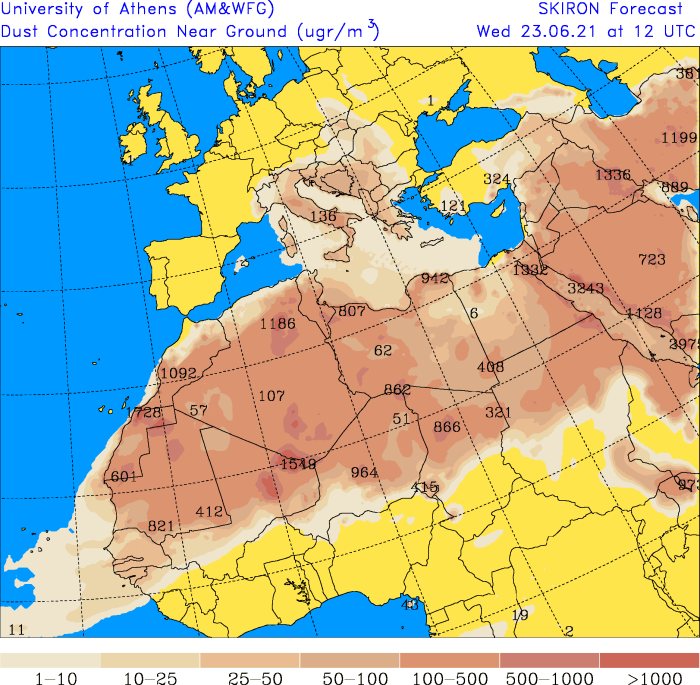
Strange thing about the weather is that sky is not clear, it's dimmed and blurred, but there are no clouds anywhere. First thought was that's kind of a haze, due to high relative humidity, common thing from time to time here over the bay of Kvarner, but I was wrong since hygrometer on the wall hasn't shown much above 60% (now even ~45% on online data from automatic local weather station).

On Monday, we went up to Učka mountain top nearby and realized that this "haze" is not only above the Kvarner (1st photo below), but also on the other side, above Istria as well (2nd photo).

View attachment 46384

View attachment 46385


And yesterday evening saw a FB friend's post with explanation that it's dust/sand from Sahara (image below), with forecast saying that it'll reach maximum concentration tomorrow and only go down during the following weekend.

072.zoomdconc.png

Sky got cleared of all the dust/sand from Sahara even before the weekend, but the heat remained here at the Northern Adriatic, Kvarner Bay.
It was 33°C-34°C for most of the afternoon every day (and well above 20°C during the night which made sleeping somewhat challenging) until today, when with the slightly fresh breeze came also some clouds (even ominous looking ones) passing by above and temperature 'dropped' to much more tolerable 30°C (and lower).
Still not a drop of rain though, for what seems more than two weeks now, which is very/highly unusual for this region.
 
Well here in BC, Canada, we are still sweltering in the heat with no respite, now this devastating news, from Lytton, the whole town has to be evacuated due to wildfires.


The mayor of Lytton, B.C., said he has ordered the entire town to be evacuated after a fast-moving wildfire swept in on Wednesday evening.

Mayor Jan Polderman said he told everyone in town to leave as the situation rapidly deteriorated.

"It's dire. The whole town is on fire," Polderman told CBC News. "It took like a whole 15 minutes from the first sign of smoke to all of a sudden there being fire everywhere."

Fire information officers with the B.C. Wildfire Service said they were unable to provide an update on the situation in the Fraser Canyon village.

This week, Lytton recorded the highest temperature ever seen.
 
It´s autumn here in NRW, Germany; I woke up to 13 degrees, my kids are wearing full autumn clothes for school - jacket and long sleeves.

It´s wet from rain that keeps falling, no sun in the sky in last 4 days and prognosis is the same for the next 10 days - clouds and rain, although the temperature should go up to 22, some days to 27 degrees - with overcast and more rain.

I don´t think that´s normal; I was not born here, but I do remember that in last years, there were periods of rain, and it was colder in the morning like 14-15 degrees, but it would go over 25 in the afternoon, so one would have to wear layers of clothes.
It just seems more rain and clouds than before....

For example I found some statistics for NRW; I summarized data for spring below, and in general temperatures were lower than average with more rain and less sunshine. On the other hand, winter was a bit warmer than average, although it didn´t feel like that. I feel like this cold weather is prolongated to spring and now to summer, which is also shown by the data below.

Cold, wet and less sunshine: Spring 2021

The below-average temperatures from March to May are also reflected throughout spring. At 7.6 ° C, spring 2021 was 1.9 Kelvin below the mean (9.5 ° C) for the reference period 1991-2020. Spring 2021 is the coldest since 2013 and is number 12 of the coldest springs since 1881. In the overall view, a very clear rise in spring temperature of 1.7 Kelvin can also be seen here.
1881-19101961-19901991-20202021
7,8 °C8,3 °C9,5 °C7,6 °C

Rainfall
1881-19101961-19901991-20202021
172 l/m²205 l/m²177 l/m²190 l/m²

Hours of sunshine
1951-19801961-19901991-20202021
459 h441 h497 h474 h

The baseline days in spring 2021 show the average cooler temperatures. The 20 frost days for the WAST station are divided into 8 in March and 12 in April. Due to the situation, there was no more frost day at the VKTU* station. In general, the temperatures at the WAST* station are cooler and reach a minimum value of below 0 ° C, while the minimum temperature at the VKTU station is just above 0 ° C. The few summer days for both stations were registered in May.

*the station Köln –Turiner Straße (VKTU) is shown as an inner-city station, and on the other hand, the Warstein station (WAST) in Warstein

Cold and wet: May 2021

The weather was also rather cool in May, but there was an above-average amount of precipitation with correspondingly below-average sunshine.

Just like April, May was 10.9 ° C, well below the temperature of the reference period 1991-2020 (13.3 ° C) and thus follows on from 2020 and 2019. Compared to the total period since 1881, May 2021 is the coldest May 21st. It was also the coldest May since 2011.
Overall, as can be seen in the table, the temperatures rose by around 1 Kelvin in May, despite the below-average temperatures of the last two years.
1881-19101961-19901991-20202021
12,2 °C12,4 °C13,3 °C10,9 °C

Rainfall
1881-19101961-19901991-20202021
60 l/m²72 l/m²64 l/m²90 l/m²

In addition to the above-average rainfall, this year's May had a below-average length of sunshine hours (202 hours) with 158 hours. May is the 13th month with the least sunshine on record. In general, however, May shows an increase in the number of hours of sunshine over the 30-year-old average.
1951-19801961-19901991-20202021
195 h190 h201 h158 h

This shows the generally below-average temperatures of May 2021.


Sunny, dry, cold: April 2021

Initially warm temperatures under the influence of subtropical air were replaced by cold, northern currents in the rest of the month. April was sunny and dry, but also cold.

At 6.2 ° C, April was 3.3 Kelvin below the average for the new reference period 1991-2020. The last time such a large discrepancy was recorded was in 1986. After April in the previous year with 11.2 ° C was significantly above the average of the reference period 1991-2020, April 2021 was 5 K colder than April 2020. April 2021 was the 17th-coldest April since records began. The following table shows very clearly that despite this cold April 2021, the temperatures rose massively in the new reference period.
1881-19101961-19901991-20202021
7,6 °C7,9 °C9,5 °C6,2 °C

Rainfall
1881-19101961-19901991-20202021
49 l/m²62 l/m²48 l/m²41 l/m²

Sunshine
1951-19801961-19901991-20202021
154 h148 h174 h174 h

The cold April can be concretely mapped using the distribution of the knowledge days for Cologne and Warstein. While there were no frost days for VKTU, WAST has 12 frost days. In March there was another summer day. April, on the other hand, has no summer days at either station. The fact that the maximum temperatures for both stations are below 10 ° also speaks for a cold April. Due to the location, WAST was overall significantly cooler than VKTU.


After extreme in February, back to normal: March 2021

Average temperatures, little precipitation and many hours of sunshine. This is how March 2021 can be briefly described. After a February with temperature extremes, it became average again in March.

At 5.8 ° C, the temperature in March 2021 was slightly above the average temperature of the reference period 1991 - 2020. An increase in temperatures was noticeable this year, especially towards the end of the month. Since the beginning of the recording in 1881 there has been a clear increase in the air temperature in March of almost 2 Kelvin.
1881-19101961-19901991-20202021
3,7 °C4,5 °C5,7 °C5,8 °C

Rainfall
1881-19101961-19901991-20202021
62 l/m²71 l/m²65 l/m²59 l/m²

Sunshine
1951-19801961-19901991-20202021
110 h103 h122 h142 h

March was marked by fewer extremes.


Average: Winter 2020/2021

After December 2020 started a little too warm, January and February almost corresponded to the average temperature of the long-term reference period 1991-2020, so that there is a slight upward deviation of +0.6 ° C for winter 2020/2021.
1881-19101961-19901991-20202021
1,0 °C1,7 °C2,7 °C3,3 °C

Rainfall
1881-19101961-19901991-20202021
190 l/m²223 l/m²237 l/m²228 l/m²

Sunshine
1951-19801961-19901991-20202021
146 h151 h165 h160 h
 
Here in Alaska, it is warm with the 3rd sunny day in a row. It has reached 80F the 1st day, 82F the 2nd, and today it looks like it will go higher, but the temp doesn't peak until 3:00PM or so.

Yesterday there were contrails all over the sky, and they turned the sky lighter blue and made cirrus type clouds. The jets were going both north and south, and one squad of 4 made a box pattern of contrails. They were higher than the normal jet skylanes, as I saw the normal jet traffic that wasn't leaving contrails.
 
Sky got cleared of all the dust/sand from Sahara even before the weekend, but the heat remained here at the Northern Adriatic, Kvarner Bay.
It was 33°C-34°C for most of the afternoon every day (and well above 20°C during the night which made sleeping somewhat challenging) until today, when with the slightly fresh breeze came also some clouds (even ominous looking ones) passing by above and temperature 'dropped' to much more tolerable 30°C (and lower).
Still not a drop of rain though, for what seems more than two weeks now, which is very/highly unusual for this region.

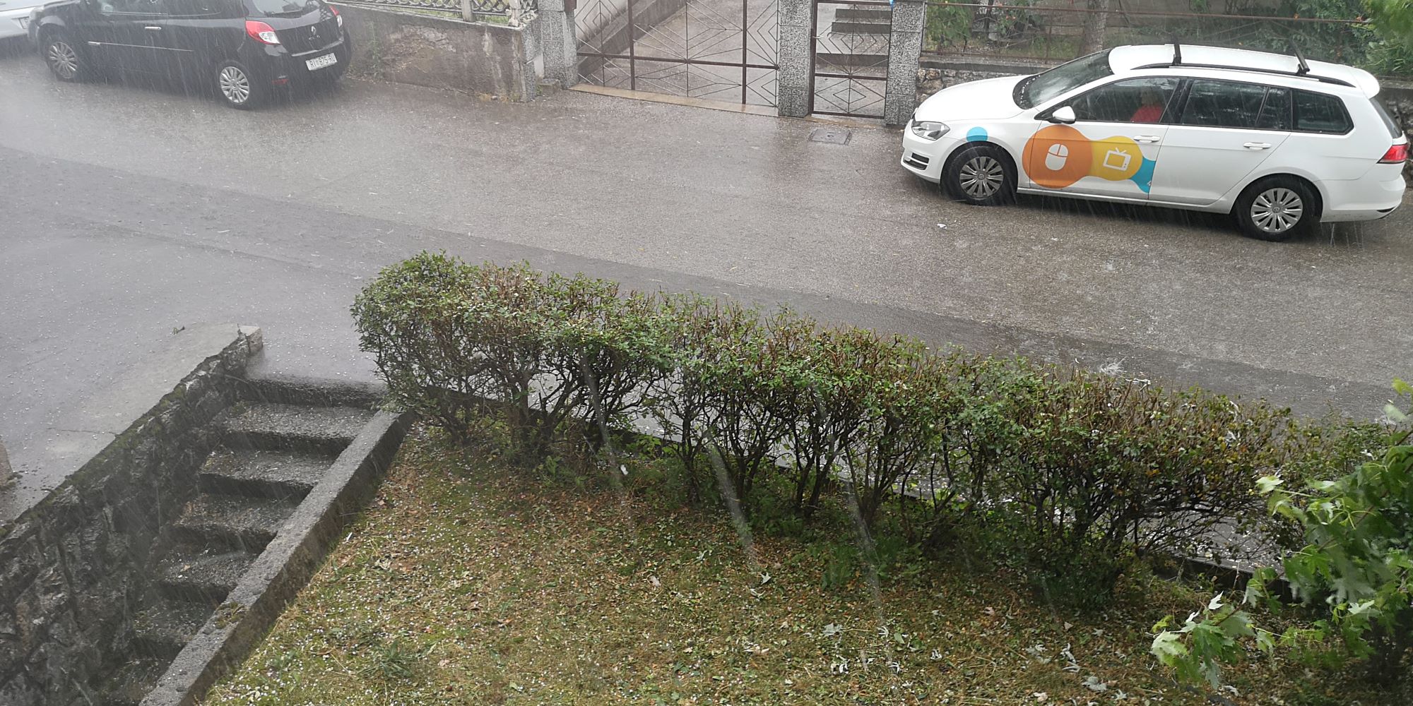
Finally some well desired rain today with temperature drop to 18°C.
Unfortunately, there was also hail (as big in size as ping-pong balls) in some/many parts of Rijeka, Kvarner Bay biggest city. :-(

tuca-drenova-010721.jpg


On the other side, together with nice freshness, the sky was rather beautiful afterwards (photo below, Učka mountain in the background).

20210701_195120.jpg
 
Back
Top Bottom