You are using an out of date browser. It may not display this or other websites correctly.
You should upgrade or use an alternative browser.
You should upgrade or use an alternative browser.
What's the weather where you are?
- Thread starter Maia
- Start date
The Northern and Adirondack region of New York State has so far experienced a very different July than the norm. Sheets of rain and flooding in some areas are reported. The ground is saturated and cannot take all that has been coming. Normally, July is quite hot as well and high 80's and into the 90's is the norm. This year it hangs in the high 60's and low to mid 70's with rare breaks of sunshine. This trend is especially noticeable because this is a tourist area with many rural sections where tourism is the main income for many. Having gone through the limitations of last season many businesses were hoping to make it up this year just to survive. I do not know how tourism has been affected as yet and we still have some time left in the summer season. People are anxious to get out of the cities and come here as so many are vaccinated and they feel safe and yet, I see them wearing their masks in the fresh mountain air...
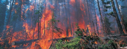
Here's an article to go along with the photo.Forest fires in Northern Saskatchewan:View attachment 47317
XPan
The Living Force
A fantastic display of
Noctilucent Clouds over Stockholm
One of the prettiest and largest displays I can remember, because everything radiates outwards in almost symmetric way - and that I haven't seen for quite a while. Now that the nights are not as bright anymore - Noctilucent Clouds stand out much more pronounced. This is a stitched panorama display made out of 3 images (with a 50 mm ƒ 1.2 L lens - handheld around 0.4 seconds without a tripod - yet razor sharp. You can also see low clouds at 1.5 km height as horizontal stripes appearing dark against the 80 km high noctilucent clouds.
The air is fresh - around +15°C. and the winds a bit gusty (but giving a nice cooling effect in our apartment, having all the windows open, chasing out the excessive heat built-up from daytime).

40 minutes later
Here is a photo i took 40 minutes later showing the fine details in the higher layers meandering.

another 20 minutes later

Noctilucent Clouds over Stockholm
One of the prettiest and largest displays I can remember, because everything radiates outwards in almost symmetric way - and that I haven't seen for quite a while. Now that the nights are not as bright anymore - Noctilucent Clouds stand out much more pronounced. This is a stitched panorama display made out of 3 images (with a 50 mm ƒ 1.2 L lens - handheld around 0.4 seconds without a tripod - yet razor sharp. You can also see low clouds at 1.5 km height as horizontal stripes appearing dark against the 80 km high noctilucent clouds.
The air is fresh - around +15°C. and the winds a bit gusty (but giving a nice cooling effect in our apartment, having all the windows open, chasing out the excessive heat built-up from daytime).
40 minutes later
Here is a photo i took 40 minutes later showing the fine details in the higher layers meandering.
another 20 minutes later
It is summer in Mexico, however, it feels cold in Toluca. We have a temperature of 13 grade Celsius and it is a stormy afternoon as a consequence of the passage of Tropical Storm Guillermo over the Mexican Pacific. The National Meteorological Service indicates that all rainfall will be accompanied by electric shocks.
XPan
The Living Force
Noctilucent Clouds changing fast
as they now make funny figures in the sky... It is really fascinating to watch the show. As the sun is slowly rising, the sky is getting ever so slightly brighter - the Noctilucent clouds are "rising" higher as well expand to the east horizon (= more of them get illuminated, which earlier were invisible when the sun was lower) - at the same time they are starting to fade...
Before they fade entirely, they can cover more than half of the sky.
Last edited:
Metrist
The Living Force
In Alaska today it is cloudy and 64°F
Theory for strange weather
After this recent heat wave in Alaska, it clouded over and cooled, although the temps dropped, it seemed warmer than expected under the cloudy conditions.
So, day before yesterday, I was awaken by the sound of rain. Normally, our rain is like a drizzle, but this rainfall was heavy - with streams of water running off the roof. I don't hear it rain in the usual conditions. Luckily, it only lasted a few minutes, then slowed to a drizzle...
But, as well as the heavy rain, there was a vibration - I thought to be the beginning of a quake. So, I've been thinking about what is actually happening with the strange weather - the drought, rains, ect. And that the atmosphere is loading with moisture, and it is staying aloft until a shadow is cast, and then condensation, rain.
So, it got me wondering... If vibrations can trigger the rains just as cooling does. And when a earthquake happens it vibrates the dense air, leading to a similar outcome as condensation. And since the air is loaded with water, whence it becomes droplets, it has a avalanche effect, resulting in deluges, but rather than rolling down a mountain slope, it is nebulous, drawing into itself from the surrounding air... So rather than clouds getting so thick it cools and rains, a alternative is vibrations coming from the earth: quakes, volcanoes.
We see water - when vibrated form those beautiful structures - well, that is the thinking behind this theory.
Long range forecast has changed. For next 2 weeks, temps in high 20s with minimal possibility of rain. Night temps approx low 20s, not too bad for sleeping. Smoke pollution from fires in the north, Alberta, BC, and Manitoba, but it's been a lot worse where you could smell it.
34 today. but dropping to 12 tonight for well-needed relief. SW wind at 14k/hr. Wind, scirocco-like, very hot and dry. Real danger of fires in dried out crops and pastures. Ranchers must be getting anxious. Hay crops are probably suffering and surface water supplies are also probably heavily impacted. Good news is smoke pollution has pretty well cleared up. There is a thunderstorm watch for this evening, so hopefully it will bring some needed moisture, if it happens, and that's a big if.
Had helicopters on reconnaissance last night as smoke dropped heavy into the valley - nothing large wildfire-wise close by, though.Smoke pollution from fires in the north, Alberta, BC, and Manitoba, but it's been a lot worse where you could smell it.
Curiously, the last three nights (despite day time warming) it has been very cool, down to 7 C with overnight moisture recovery. These are usually late August conditions.
XPan
The Living Force
Scattered Thunderstorms
over Stockholm, 28 July 2021
Just some scattered, erratic thunderstorms hovering over our city with nice thunder sounds rolling though the air - but nothing special or dramatic, and they appear every 3-4 minutes; well, the Nordic style, you know; you just never get that dramatic central or south European "fireworks" style...
After a long time of really warm to hot weather up to 30°C/86°F (last days) - it seems we are now transitioning into a cooler phase with max 20°C / 68°F during daytime. The last nights have felt sticky with a "tropical feeling"; humid, warm and cloudy.
Cool calm and preparing.
lilies
The Living Force
37°C / 99°F in shadow. Hot air is blown around by medium strength winds in another heatwave in Hungary, ~90 miles west of the Ukrainian border. We had almost a week of relief: ~8°C degrees down from the above max. Meteorologists say next week it'll cool down. In such a heatwave by ~01:30am the air cools down sufficiently so I can sleep.
Last edited:
XPan
The Living Force
Small line of Thunderstorms
Stockholm, 29 July 2021
Just as a side note, I just heard a rumble realizing that a line of thunderstorms are passing by Stockholm. Albeit it much more lively inland of Sweden in terms of showers and thunderstorms. Temperature here is 23°C / 73°F

Summer 2021*
Stockholm Station A (City)
Since I haven't looked at the archived MIN & MAX temperatures for Stockholm in several months, I downloaded the numbers from SMHI today, in order to see them transformed into my own illustrations; And that's what it looks like: As you can see, in this part of the world, summer has this far been a very warm story. A few times even hot at or over 30°C / 86°F
Overall summer has been a lot warmer than normal for 2 months in a row, with daily MAX never below 20°C (quite remarkable!), and many been above 25°C, which we call "a summer day".
*) 1 June to 27 July 2021


Stockholm, 29 July 2021
Just as a side note, I just heard a rumble realizing that a line of thunderstorms are passing by Stockholm. Albeit it much more lively inland of Sweden in terms of showers and thunderstorms. Temperature here is 23°C / 73°F
Summer 2021*
Stockholm Station A (City)
Since I haven't looked at the archived MIN & MAX temperatures for Stockholm in several months, I downloaded the numbers from SMHI today, in order to see them transformed into my own illustrations; And that's what it looks like: As you can see, in this part of the world, summer has this far been a very warm story. A few times even hot at or over 30°C / 86°F
Overall summer has been a lot warmer than normal for 2 months in a row, with daily MAX never below 20°C (quite remarkable!), and many been above 25°C, which we call "a summer day".
*) 1 June to 27 July 2021
Trending content
-

-

-
Thread 'Coronavirus Pandemic: Apocalypse Now! Or exaggerated scare story?'
- wanderingthomas
Replies: 30K -