What's the weather where you are?

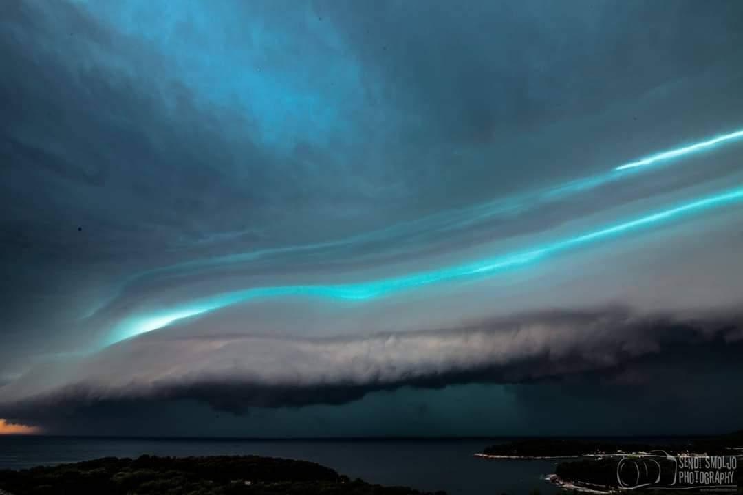
Northeastern Pennsylvania - In the last two weeks, day temps have averaged around 86-92F with high humidity.

For the last three days, around 4:30 - 5PM - dark gray clouds will roll in. The rain doesn't start out with just a few sprinkles - there will be a loud clap of thunder and then "all-hell-breaks-loose"! Large heavy rain drops pelt everything. The sound is almost deafening. Within about ten minutes - roads and sidewalks turn into raging rivers.

Another ten minutes later, the rain abruptly stops, the sky begins to clear and get brighter and you could almost hear "a pin drop" it's so quiet? I'm totally convinced - I'm living in the Twilight Zone! Tomorrow is forecasted to be a repeat. Oh Joy!

We're only 4 months away from getting some serious snow - I pray, the snow doesn't come down like these rain drops?
 
Last night Split@Dalmazzia experienced some real nasty storm that felt almost like tornado. It did come suddenly and violently shortly noticed by some freakin' wind jet bursts that lifted copious dust and debris in the air 🌬 and clouds covered wider area in matter of seconds. After little time rain followed in copious amounts "falling" almost horizontally/all directions - sometimes even upwards ⏫.

Curious thig is that i observed multitudes of lightning flashes in skies - but heard no sounds of thunder :umm:

Today i've witnessed a lot of leaves and broken branches on local roads...and really nice supercell was photographed:

shelf_clouds1.jpeg


obn6xomg1scklo7dprzk.jpg


Last edited:
A new Heatwave over Macedonia. Yesterday was probably the hottest day this year. In the place where I live, it was over 40C during the day and at evening it was still very hot so when I went outside I was like someone is blowing with a hairdryer in your face.
Very hard to sleep and to function normally during the day.
 
If this summer began with about average thunderstorm and weird weather activity in Southern Scandinavia/Denmark, it has continued. Now at the end of the summer, it is tme to present a couple of highlights. The Wiki says that there were many waterspouts in 1999 and 2002, but this year has also had something to show, and very similar to what Palinurus reported above. One waterspout from August 8 over Hornbæk gave many people an opportunity to take some great photos, as the weather was alright on the beach: Imponerende skypumpe ud for Hornbæk torsdag - se billeder og videoer
31275
And earlier in July there was one over the island of Lolland:
On one occasion around June 20, very large hails fell: Så usædvanlige var kæmpehaglene over Vestjylland
And on June 14, in the town of Aabenraa there was a small, but short lived tornado Biler blev væltet rundt - Aabenraa var ramt af tornado
31279
Last week one place got hit by two downpours in one day, (during each event there fell more than 15mm/half an inch in 30 minutes). I happened to observe one of them, and if I had some experience and had not paid close attention to the speed of the clouds, while it was seemingly still calm where we were sitting, we would have become wet, because it changed within seconds and the street lights came on. The way the clouds moved that day was something to remember, their colour was within the normal dark thundercloud range, but their speed - scarry!
 

Attachments

  • 1565796033526.png
    1565796033526.png
    516.7 KB · Views: 3
  • 1565796234023.png
    1565796234023.png
    433.9 KB · Views: 3
National heat wave confirmed in the Netherlands, the second one for this year.
<...>
Two national heat waves in a year is very rare, according to the weather service. This is only the fourth time it's happened in the Netherlands since temperature measurements started in 1901. The other years with two heatwaves were last year, 2006, and 1941.

This heat wave also broke the record for the latest heatwave in a year. The previous record dates from 2001, when there was a heat wave between August 22nd and 26th. This one will last at least until today, August 27th.
<...>

More details here:
Second national heat wave in NL; smog warning issued
It's official: second nationwide heatwave hits the Netherlands - DutchNews.nl
 
Last edited:
Correction. Much farther north of here near Lyon, Italy, and Switzerland.
 
Brazil's Southeast:

We're still in winter but temperatures are already 22°C at 6 in the morning and 38°C in mid-afternoon. I averaged the maximum temperature reading for September in my current city from 2001 to 2018 and the result was 33°C. That's a difference of 5°C, although there were peaks above 37°C in 2004, 2011 and 2015, all for September.

I highlighted the highest value for each month in the tables below (source). The first table gives the maximum temperature in a given month, the second gives the monthly average of the highest daily temperature. Things have been heating up around here since about 2014/2015. May, August and September 2019 have the highest max temps since 2001.

31625

31626
 
Mid North Coast NSW, Australia

Two days ago it was a mild 25*C, & then the next day temps dropped to 15*C overcast & cold (by Aussie standards), today hovered at 19*C. We had a bit of rain on the coast, but our farmers are still not getting any out West :/
 
Significantly colder weather this morning in western parts of Macedonia. At 8:00 am the temp was only 9C.
On higher places it was much colder. Maybe the winter is coming much earlier this year.
 
Back
Top Bottom