What's the weather where you are?

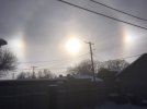
I went for a walk yesterday and wondered about this strange sky beforehand. It was like it was somehow surreal. Everything was yellow/orange. And it was eerily quiet... although cars were driving. I can't really describe it. Unfortunately, I only had my mobile phone with me to take pictures and with all the automatic enhancements that modern mobile phone cameras have, I couldn't capture this image. It was very strange.
Then this morning I found this article on Sott.net and maybe it could have been an offshoot of that. But I don't know. We live in Nuremberg, which is towards the south in Germany. Today the sky seems to be back to normal, but heavy snowfall is predicted by the weather services in our area as well. I am grateful for home office for the next 4 weeks. :cool2:

Wow @Mililea

You are truly observant.
What you likely saw was the dust blowing from the Sahara northwards all the way to Southern Germany ! It was reported in the Alps, due to the strong flow of very mild air over Southern Europe drifting to the north.


Auto White Balance issues

Yeah, and those mobile phones sux, because their automatic white balance always iron out any color shifts. What you could do, is to enable a filter on purpose, so that the final results resemble what you naked eye saw ! That is a workaround to the problems with auto white balance.


Tropical Night in Sicily

In Sicily the stream of warm air created very strong Scirocco wind (kind of like Föhn winds in the Alps can do, which exaggerate high temperatures due to their nature of falling down behind a mountain chain, on the lee side it dries out, and the movement down accelerates the rise of temperature further. Often attached to very high wind speeds)

So, that situation created over the North Coast of Sicily temperatures up to 29°C in Palermo and 28° in other locations along the North Coast - as well a few places recorded tropical nights (MIN temperatures not going below 20°C). Even in Catania on the east coast of Sicily, reported a MAX of 25°C

My husbands ex Wife, Mary, went to the beach of Catania, taking a swim !!!

The photo below, from 6 Feb 2021, I got from a friend who lives in Catania.


IMAGE 2021-02-07 12:31:58.jpg
 
Yeah, and those mobile phones sux, because their automatic white balance always iron out any color shifts. What you could do, is to enable a filter on purpose, so that the final results resemble what you naked eye saw ! That is a workaround to the problems with auto white balance.
I tried to edit one of the pictures I took from my window after the walk to what it really looked like. But you really can't take it exactly like that, because that whole strange mood also contributed to it. Even my husband's 10-year-old son said it looked like apocalypse. :flowers:
yellow sky.jpg
 
2021-02-07_05.jpg

I have never seen it myself

Except when I visited Antalya, Turkey on 6 Apr 2008 - as all of the sudden approaching Thunderstorms had a weird reddish-yellow glow coming down over the Sea. As it was right in the middle of the day, i only could have been sand from Africa pulling in. After all, the distance to the South Coast of Turkey isn't that far. Luckily I also saved a satellite chart - which confirmed the presence of sand blowing into Turkey.

In Sicily it is pretty common with Sand blowing from Africa, since the distance is even closer to the African continent.

2021-02-07_04.jpg
 
I took this photo yesterday afternoon. The second day in a row for sun dogs. We get them a few times a year, but yesterday's solar show was brighter than any I can remember. With the windchill, the temp. was hovering near -40 C.
 

Attachments

  • IMG_2843.JPG
    IMG_2843.JPG
    33.8 KB · Views: 9
A few observations from Scandinavia/Northwestern Europe
From Norway:

From summer paradise to winter paradise
Published 5. Feb. at15:51 Updated 5. Feb. at 19:42
Ski trails on beaches at the far end of the sea are a rare sight in the southernmost parts of the country. Now there are many who replace shoes with skis on the legs.
1612786045478.png
There was also:
Current consumption record: - Do not charge the electric car in the morning
Thursday morning we used more electricity than ever before in Norway. Now Statnett is asking people not to charge and heat the electric car in the morning.
From Sweden - sea ice increasing in the Baltic Sea
For the Southern Baltic sea there is now a warning about the formation of new ice from the Swedish Meteorological and Hydrological Institute www.smhi.se
1612784761812.png

From Denmark - ice suitable for skating is forming on the lakes
In Denmark there has been frost on a permanent basis for about 10 days with 0-8 degrees Celsius below and mostly 0-5 since it is close to the sea. However the lakes have been gathering ice and some have begun to skate. Probably not solidly safe just yet, so today they issued advice on how to move safely on lake ice. For instance:


As a general rule, the ice must be 13-18 cm thick before you should move out on it, but the carrying capacity of the ice also depends, among other things, on current conditions at the individual location. Ice, which to the naked eye looks safe, can therefore be an insidious affair and life-threatening to move out on.
'As a rule of thumb, ice is said to grow by 0.1 millimeters per minus degree per hour. [...] 'says DMI's climatologist Mikael Scharling.

Example:

The temperature is constantly at five degrees below zero for a whole day
24 hours * 5 degrees frost * 0.1 millimeters ⇒ 12 mm increase in ice
'However, it is only a rule of thumb and the ice formation on a lake is affected by many other factors. That is why you should never use the rule to assess whether the ice is safe on a lake, 'warns Mikael Scharling.

How fast the ice grows also depends on how thick the ice is and whether there is snow cover.
Since ice on the lakes approaching the level where skating is permittable has not been a regular yearly occurrence they have some suggestions what to do in case there is a problem.
Deep cracks in the ice are called curtains. They can be used to judge the thickness of the ice, as the ice is always at least as thick as the curtains.
If the ice breaks in star pattern when you step on it, it is not thick enough to walk on.
If the star pattern in the ice is surrounded by circular cracks, then you are about to go through the ice.

If you fall through the ice
Avoid panic and get control of your breathing.
Search back to where you fell in and put your elbows on the ice.
Cry for help!
Swim with your legs, kick backwards and climb up on the ice.
Move your way forward towards land until the ice can bear again.
Save your energy if you can not get up. Move as little as possible.

Help someone who has fallen through the ice
Call [Emergency service number].
Do not go close to the hole in the ice, you will fall in yourself.
Lie down on your stomach.
Throw a lifebuoy or other rescue device to the person in the water and hold on to the line.
Use a branch or scarf in the absence of rescue equipment.
Never reach out your arm!
 
2021-02-10.jpg

Cold Sweden

But nothing out of the ordinary. After all - we have now reached the lowest point of the annual mean temperature curve - where cold temperatures is exactly what we find now, but by no means anything extreme.

All of Sweden is covered with snow ⛄ now
All stations report temperatures below 0°C / 32°F (24 hours)


Svanberga -27°C / -17°F

Near Stockholm you see an area just 75 km NE of Stockholm - called Svanberga / Norrtälje. That location sticks out considerably with -27°C / -17°F since 2 days - while all surrounding stations reported higher temperatures. Today the same "cold pool area" (dark blue) has spread and become a little wider (and colder), even starting to include Stockholm City as well the southern outskirts where I live (it felt ice cold as I walked home from work an hour ago, around -17°C / 1°F)


A Little Cold Pool

I believe the present little "cold pool" north of Stockholm, has something to do with that the area, is free from clouds, has weak winds from NE, and the ice towards the close Åland islands, create ideal conditions for very cold temperatures just inland.

While the Area south of Stockholm has cloudy weather (and some weak snow showers pulling in) dampening the temperatures, especially at the coast, reporting only -4°C / 25°F (Landsort Station)


Swedish (Scandinavian) Cold Record** -63°F

Was recorded back in February 1966 with -52.6°C / -63°F in a place called Vuoggatjålme*

Now try to melt
that on your tongue... :lol::lol2:


*) Vuoggatjålme with -52.6°C is considered to be the cold record for entire Scandinavia (Danish Greenland excluded)
**) A private measurement in Malgovik / Malkoemehkie , with -53°C / -63.4°F Dec 1941 - is acknowledged as a comment by the Swedish weather authority SMHI.
 
1612993124336.pngIt has beaen very cold here in south East England Last few nights there has been a sprinkling of snow and image is out of my window where we see a little gathering.
Forecast is just for a few days here it will be cold like this and then warm up relatively quickly.
 
I have only recently lived in southern Ohio and I have never seen it snow as much in the last 5 years as it has these last two weeks this winter and it is now -6 C and by the weekend it will be down to -15 C by midnight.


149436522_270454221274587_2095366080026053332_n.jpg146672960_992830214576377_6246853606884796684_n.jpg147310386_226875252459169_9015474625877755264_n.jpg
 
If you like detailed temperature charts of Europe ?

Then I have two links for you, which show every day the >MINIMA (link) and >MAXIMA (link) temperatures measured around Europe (and a bit outside), in a tight grid coded with colors, which makes them visually easily accessible. The original charts are nicely big (1440 × 1080 px). I use them every day when I study weather parameters.


Good to know:

1) Many of these stations are automatic stations; in relatively rare cases, one can report wrong numbers. (It happens quite often with Precipitation Charts where one suddenly bails out showing extreme amounts).

2) Another phenomena that can happen is, that a whole area has no reports of temperatures.

3) Keep in mind a phenomena not easy to discern: You can see unusual low minimum temperatures in an area (for example Lisbon, Portugal) - because the station from which is reported from, is located on other side of the Tejo River (Montijo Air Base). During autumn-winter-spring it is usually much colder there, compared to the City core of Lisbon. (6-8°C difference) It took me a couple months to understand what was going on :wow: If unknown to the viewer, you are given the impression that "a city reports extreme low temperatures" - but the answer can be a geographical one...

4) All temperatures are shown in °C


Enjoy 💕


To give you an example of how these MIN/MAX charts look like:


MIN.jpg

MAX.jpg
 
In February, in Bonn, the average high-temperature is 5.2°C (41.4°F), and the average low-temperature is -0.2°C (31.6°F).

Well, we have last days -10 in the night and around -1 to 0 in the day.

There was a bit of snow but it doesn’t last long here. Bonn has some micro climate caused by Rhein river and long time residents say that there never was much snow...
Temperature should go up next week to 8°C... Well see...
 
East EU, Hungary, Carpathian Basin:
Weather forecast predicted 9mm of snow for today. Ten times of that amount fell however: about four inches. They also predict way below freezing temps for the weekend. So, I figured it will snow a lot more and it will ice-over badly in the next couple days.

They don't list snow for Friday, only the "deep" freeze:
Snow Management.jpg

Marked my intervention with a red circle. (2x) Around 17:00 today, before sunset*. Effects, if any, should be observable by morning. The weather-service updates their charts real-time, so the above capture from Thursday afternoon usually changes by next day. The above pic is what they thought the weather will be.

Normally, untouched natural-weather (as per forecast) should be: everything frozen badly on Friday, creating very hazardous icing on the walkways and risky-for-biking, uneven frozen-hard snow on roads.

In order to not have to shovel inordinate amounts of fresh snow in the next three days, decrease the heating bill and also to prevent [city-wide] the elderly falling / slipping and breaking their bones on the ice (and me skidding with my bicycle which has puny, thin tires):
I employed the new method, reported here last year. Its a round-breathing of [possibly] +/- ion charge from [possibly] the ionosphere.
As I reported here years ago, the previous (old method) always increased temperatures city-wide, melted the snow, cleared the ice and it rained a lot instead, without the rain freezing during winter nights.

New method:
Preliminary (casual) applications in December 2020 showed similar results. What I'm curious about how it will affect these "very low" sub-zero temps forecast.

Today, what snow fell, already started to freeze badly. Both methods effects usually kick in on an average of 12 hours after application. Delay is more if the weather system is strong & stable = hard to "push around".

Observation #1:
I always noticed this new method is easy, when using the sunlight* as a delivery method. So this is why I did it before sunset (18:00). (Reference N#3.)

Observation #2:
This was the first test of the new method in heavy snowfall. To my surprise I noticed a significantly increased "ion / energy conductance" probably made possible by the snow. Chi-wise / energetically it felt as if the heavy snowfall facilitated "long hanging metal wires" reaching down from the ionosphere. These made it significantly easier to ""breath in more ion-charge"", as if the energy was delivered by invisible "snow-wires" hanging down from high altitude.

I tried to research, how the alleged neutrally charged snowfall could facilitate significantly increased ion-flow [called/attracted down] from [possibly] the ionosphere..
Ref.N#4.:
the parameters characterising the electrical
properties of snow are its volume conductivity,
dielectric constant, salt content, water content, volume
density, crystal structure and size, impurities, as well as
the electric field and frequency to which it is submitted
, but I was unable to figure it out. The science material is way over my head. I'm just a user of this method.

References:
1. Study: Earth and Space Weather Connected | Live Science
2. Ionospheric Weather Expert Service Centre (I-ESC)
3. photons (the quantum carriers of light energy)
4. Electrical properties of snow (PDF)
 
After several days of 10-15°F weather, it is back up to 32°F right at the freezing mark. It has been snowing just about every day, but only accumulations of only a inch or so a day.

We had a severe cold weather alert a few days ago, but it was a little further north, so we were spared from the coldness.
 
Back
Top Bottom