What's the weather where you are?

This night was also windy weather here in NRW, Germany. Wind was so strong with rain that I thought that wind will blow out my windows.

Today is quiet, with usual overcast and the rain that falls every single day, gray weather as usual for this time of the year. I think I saw the sun 1-2 times in last month. :(
Last week we had 1 night and not full 1 day of snow before it melted and started to rain - again.
Temperature today as usual 5-6 degrees.

I feel with you !! 💕

It's the same scenario up here in Stockholm (and I assume also Baltic Countries, Finland, West Russia and of course like you, in Germany) - just overwhelmingly dominated by constant overcast weather, with all the flavors that come with that weather type.

Also January has continued to go in the same line as Dec 2020 did in Stockholm with totally only 4 hours, and so far in Jan 2021 only (preliminary) 9.5 hours sunshine in total.

That is really "Not much to hang on a tree", is a Swedish saying (e.g. there is not much substance) and "Not much flesh on the bones" as my german grandmother Elfriede used to say.

Well dah... it really isn't.


View attachment 42053


Winter in Stockholm has been replaced

to my surprizee - with another period of mild weather up to 5°C / 41°F - so all snow is gone. We had at the most 14 cm snow in Stockholm - but nothing is left. A new period of freezing weather is underway, though. During the night, the water in streets and on walkways refreeze - making it highly treacherous to walk on.

The so called normal average max temperatures this time of the year in the City core of Stockholm (1960-91) is -1.0°C (30.2°F) and the average min -5.4°C (22.3°F) - and with that we are soon reaching the coldest period of the year - usually in the first week of February. Then the normal average temperatures starts to rise... Weeheeeee :wow:

But that's just the average fingerprint of things...

Weather is anything but average.
 
I feel with you !! 💕

It's the same scenario up here in Stockholm (and I assume also Baltic Countries, Finland, West Russia and of course like you, in Germany) - just overwhelmingly dominated by constant overcast weather, with all the flavors that come with that weather type.

Also January has continued to go in the same line as Dec 2020 did in Stockholm with totally only 4 hours, and so far in Jan 2021 only (preliminary) 9.5 hours sunshine in total.

That is really "Not much to hang on a tree", is a Swedish saying (e.g. there is not much substance) and "Not much flesh on the bones" as my german grandmother Elfriede used to say.

Well dah... it really isn't.


Winter in Stockholm has been replaced

to my surprizee - with another period of mild weather up to 5°C / 41°F - so all snow is gone. We had at the most 14 cm snow in Stockholm - but nothing is left. A new period of freezing weather is underway, though. During the night, the water in streets and on walkways refreeze - making it highly treacherous to walk on.

The so called normal average max temperatures this time of the year in the City core of Stockholm (1960-91) is -1.0°C (30.2°F) and the average min -5.4°C (22.3°F) - and with that we are soon reaching the coldest period of the year - usually in the first week of February. Then the normal average temperatures starts to rise... Weeheeeee :wow:

But that's just the average fingerprint of things...

Weather is anything but average.
The Missing Sunshine hour chart for Stockholm

2021-01-24-at-15-38-08.jpg
 
2021-01-26_02.jpg

2021-01-26_01.jpg


26 Jan 2021 • Winter Impressions from Stockholm

That went quick :wow: All of the sudden - fairytale winter is back in our city. This time it appears to stay that way, as temperatures are forecast to stay below freezing, at times going all the way down to -10°C / 14°F (which is nothing exceptional during winter). But later on, there are indications (GFS prognosis) that winter may still not made up it's mind about our latitude... Oh well.

The images I took, were made an hour ago on my way home from work in the morning - while it is overcast and a temperature around -3°C / 26.6°F without winds - making the views truly enjoyable to take in, while walking slowly...
 
Source: First day of moderate frost since January 2019

Sunday, January 31, 2021 - 19:30
First day of moderate frost since January 2019

The Netherlands experienced its first day of moderate frost since the beginning of January 2019. At the official weather station in De Bilt, a temperature of -5.1 degrees was measured on Sunday morning. This put an end to a record period of 740 days without moderate frost.

The town of Eelde in Drenthe recorded the coldest temperature. There, in the night from Saturday to Sunday, it was 10.4 degrees below zero.

The level of moderate frost is reached when the temperature falls below -5 degrees Celcius. The last time this was recorded was on January 21, 2019, when temperatures dropped to -8.1 degrees.

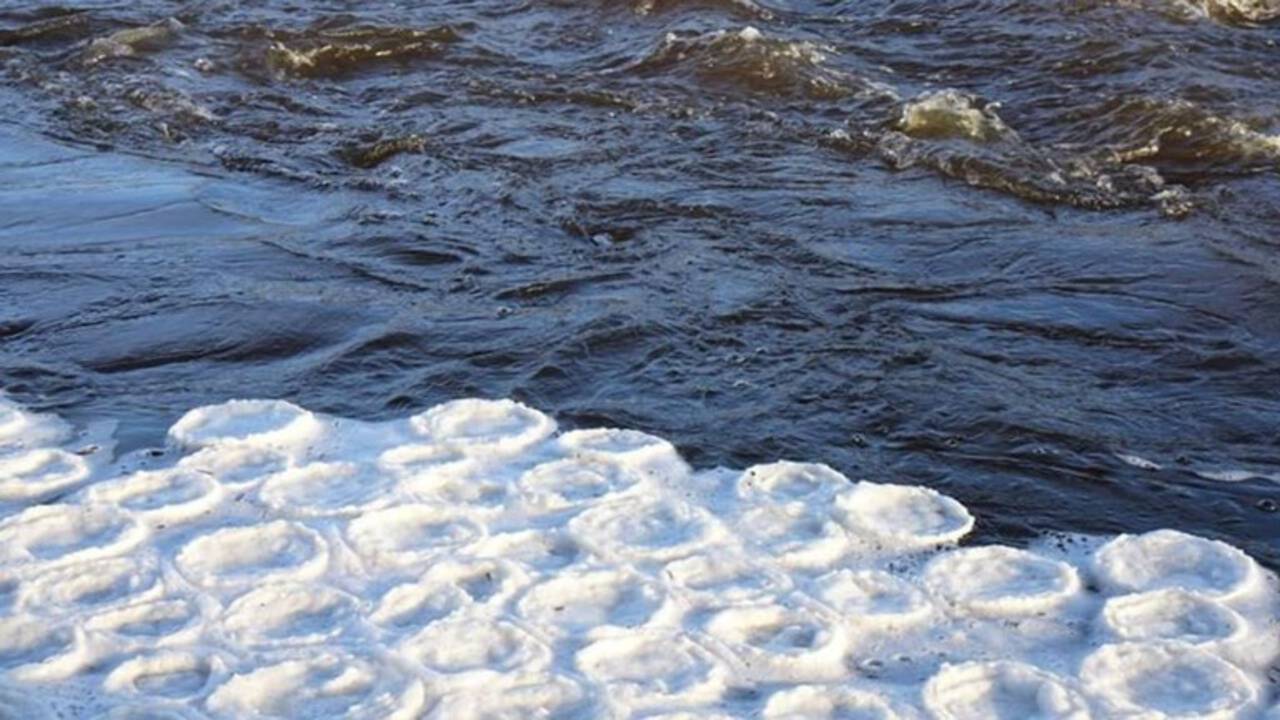
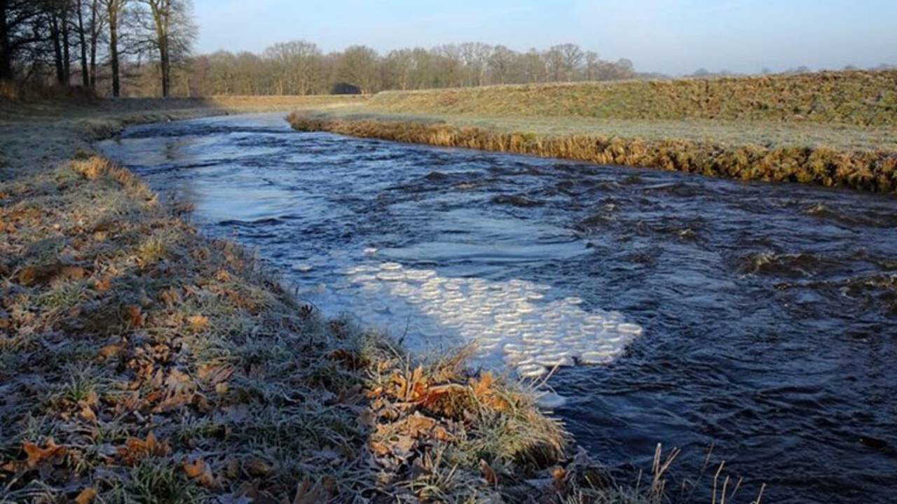
In one place. this caused a rather rare weather phenomenon: ice pancakes.

1280x720a.jpg

Ice pancakes in the Schipbeek brook - Image: Mathilde te Lintelo

1280x720a.jpg

The ice pancakes are frozen to each other
- Image: Mathilde te Lintelo

Source (in Dutch): Bijzonder natuurverschijnsel in Gelderse beek: ijspannenkoeken


NOS News - Regional News - Remarkable - today, 12:07
Special natural phenomenon in Gelderland stream: ice pancakes

'Ice pancakes' have been observed on the water surface of the Schipbeek near Rietmolen, in Gelderland. Ice pancakes, or ice circles, form on top of flowing water when small ice particles stick together and start to spin.

"That's pretty special, you don't see that very often," says Weerplaza weatherman Wouter van Bernebeek to Omroep Gelderland Radio. "They collide against the current, always against each other. That's how the round shapes are created."

Normally ice pancakes float separately from each other, but those in the Schipbeek have frozen to each other. According to Van Bernebeek, that's because the pancakes ended up outside the current.

Translated with www.DeepL.com/Translator (free version)
 
2021-02-04_01.jpg


@Palinurus

I have heard about that phenomena of Ice Pancakes several times in the Swedish recordings at the Swedish Meteorological institute - and seen photos - but never with my own naked eyes. It's really fascinating. And beautiful (especially from a photographical point of view), as well cool that it happened in Holland !

Another snow phenomena I recall is that of "snow rollers" [Wikipedia link] Where patches of snow (on a snow cover / flat surfaces) create funny rolls all over the place.... It's very rare, from what I understand and still somewhat poorly understood, how exactly they come to pass.


February 2021 in Stockholm

Started with 6 hours of sunshine. I don't know how many times my husband and went to the windows, looking out just because it felt so.... rare and beautiful, finally to have this amount of sunshine (after so long times of almost none). As of lately sunshine has been ramping up with light (and it feels slightly stronger, too). I even see that in some of my plants starting to recover - while many others are still very sad.

As you can see in the chart below, the daily sunshine hours have been exceptionally poor in Stockholm. While January 2021 made it to a total of 23 hours (preliminary numbers) - which however are still a lot lower than average.


2021-02-04_03.jpg


The temperatures

have been dipping down to -20.8°C [-6°F] at Tullinge station the other morning - at a typical "cold hole" known for it's extremes -located 7 km located from my place south of Stockholm, so we don't get it that bitingly cold - but still down to -17°C / 1.4°F. The city of Stockholm was a lot "warmer" with around -9°C. / 15.8°F. (at the lowest)


2021-02-04_02.jpg


Snow, Snow, Snow • 2 Feb 2021

:wow: Yesterday it snowed like all day long - with big classic flakes - and again, we went constantly to the windows, watching the show. And it really was.... amazing. Everything just white ! Snow depths has now increased from 13 cm to 23 cm / from 5.1 to 9.0 inch. Nothing unusual really - because not that long time ago we had at the most 50 cm / 19.7 inch (not really common) - while the all time high record for Stockholm (City) registered is I believe 66 cm / 26 inch. (year to me unknown)

Nevertheless - it is simply beautiful. It also gives a great break from the gloomy, monotone dark gray which dominated the scene for too many weeks since November, making people moody and tired. (We have been good in taking high doses of Vitamin D3+K2 around IU 5000-10000) - so I barely experienced any days of "where you never seem to wake up, and look like wrinkly puffy lemon" :scared:

With love to you from Stockholm

💕
 
The last couple days here in Alaska, were typical January conditions. About 20°F in the day and close to 0°F at night. It is a change from the normally above average temps between 20° to 30°F that has been the trend. We haven't gotten any heavy snowfalls, just a inch or two here and there.

Soon, the snow will evaporate directly and then as the heat rises and gets warmer, the break up will come and all will be mushy. But I'm getting ahead of myself.
 
En France, sur la Côte d'Azur ciel bleu et soleil, 15° en journée, il fait juste un peu frais le matin...

In France, on the French Riviera, blue sky and sunshine, 15° during the day, it's just a little bit cool in the morning...
 
Explore One of the Worlds Oldest Temperature Series
that from Stockholm, Sweden 1756 - 2021


In the link above, comes from the Stockholm's University • Bolin Center for Climate Research - you are given a unique opportunity to study the mean temperature through all years, since 1756 in a easy navigated, graphical interface.

Navigation: I don't recommend any mobile phone for playing with the flexible chart, really. Easiest and optically most beautiful is when you do it on a large screen - just slide the slider to any year you wish ! It is interesting to see, how extreme mild winters happened even back in the end of 17xx something. But also bizarre cold winters, as well.


A reminder

Stockholm isn't really that super cold, really - because of the position located near the Baltic Sea, which has a dampening effect, as well being more in the South of Sweden. In our region of the world, we are within the "westerlies", like an autostrada, the cyclones can move in an endless chain over Scandinavia.

During Winter - it usually means means plenty of clouds, mild air, rain/snow and a strong mix of the layers in the atmosphere, preventing temperatures from plunging. However - also anti-cyclones, can often bring low clouds for weeks, and usually slightly below freezing temperatures (inversions: cold air layer getting "stuck" on the ground, while warm air in the lower/middle atmosphere = overcast skies)

Well that happened most of the time Nov 2020 - Jan 2021 as the very latest example - with extreme little sunshine (as it did in Dec 1934) as consequence. Strange it is not, when you think about it...; the more cyclones dancing over the lands, the less the sun comes out.

I give you some examples of how the graphics look like - by giving you some examples. 1779, 1867, 2020.

Have fun playing ! 💕

Note:
What you see as a line (red/blue) are temperature
deviations from "normal mean temperature" for Stockholm, e.g. you see mean or Ø temperatures for each day, but no actual ones (like min/max). The Gray line / zone marks the outer extremes of mean temperatures (e.g. not min/max) which occurred throughout almost the entire time span of 1756-2005)


2021-02-06_01.jpg

2021-02-06_02.jpg

2021-02-06_04.jpg
 
Last edited:
We are expecting snow in the south-east of England in the next few hours. We have had the wettest winter I can remember for a long time. The flood plain of our local river is no longer a flood plain as such, it is a massive lake with the odd tussock popping through. My family went on a 10 mile hike yesterday through endless mud and squelch. We all nearly lost our footing many times. One small trackway was so deep in water it came up to the top of my wellingtons. The others, in standard walking boots, suffered more. One of our party fell over in the water...did we laugh....no, of course not...🤭😂😀...that would have been unkind.

If we get as much snow as has been forecast, it will add hugely to the already very high water table.
 
I went for a walk yesterday and wondered about this strange sky beforehand. It was like it was somehow surreal. Everything was yellow/orange. And it was eerily quiet... although cars were driving. I can't really describe it. Unfortunately, I only had my mobile phone with me to take pictures and with all the automatic enhancements that modern mobile phone cameras have, I couldn't capture this image. It was very strange.
Then this morning I found this article on Sott.net and maybe it could have been an offshoot of that. But I don't know. We live in Nuremberg, which is towards the south in Germany. Today the sky seems to be back to normal, but heavy snowfall is predicted by the weather services in our area as well. I am grateful for home office for the next 4 weeks. :cool2:
 
Back
Top Bottom