WORLDWIDE EARTHQUAKE REPORT SEPTEMBER 28
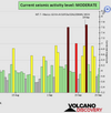
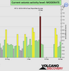
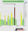
Based on the averages of all earthquakes during the last hours we had a
MODERATE seismic activity level.
Global seismic activity level chart
~11 quakes above magnitude 5
~54 quakes between magnitude 4 and 5
~94 quakes between magnitude 3 and 4
~268 quakes between magnitude 2 and 3
~472 quakes below magnitude 2 that people normally don't feel.
~899 quakes past 24 h. (911 earthquakes in the 24 hours prior to this report) Estimated combined seismic energy released: 6.6 x 10¹³ joules (18.3 gigawatt hours, equivalent to 15747 tons of TNT or 1 atomic bombs!)
Volcanodiscovery earthquake report 24h
▪︎Strongest earthquake: M 5.5 - northern East Pacific Rise
2022-09-28 22:34:47 (UTC)
8.542°N 102.733°W. 10.0 km depth
USGS earthquake alert
▪︎M 5.1 - 245 km NE of Saipan, Northern Mariana Islands
2022-09-28 21:41:07 (UTC)
16.946°N 147.180°E. 29.9 km depth
USGS earthquake alert
▪︎M 5.0 - Antigua and Barbuda region, Leeward Islands
2022-09-28 19:48:37 (UTC)
17.868°N 61.433°W. 27.8 km depth
USGS earthquake alert
▪︎M 5.1 - 239 km NE of Saipan, Northern Mariana Islands
2022-09-28 17:35:12 (UTC)
16.952°N 147.092°E. 32.7 km depth
USGS earthquake alert
▪︎On September 28th earthquake swarm continues in Reykjanes Ridge. According to USGS data 14 earthquakes so far. However, in the last 9 hours only one M4.7 earthquake has occurred.
M4.6 at 00:22:52 (UTC)
M4.9 at 00:55:09 (UTC)
M4.8 at 01:43:26 (UTC)
M4.5 at 02:22:36 (UTC)
M4.6 at 03:41:36 (UTC)
M4.7 at 06:09:46 (UTC)
M5.0 at 06:46:22 (UTC)
M4.9 at 07:59:37 (UTC)
M4.6 at 09:06:07 (UTC)
M4.7 at 09:50:58 (UTC)
M5.1 at 10:03:05 (UTC)
M4.6 at 12:30:44 (UTC)
M4.6 at 12:49:10 (UTC)
M4.7 at 21:11:18 (UTC)
This release of energy could also trigger things in Iceland which in geological terms is next door, 3000 km, I would think. So it could trigger earthquakes or volcanoes on Iceland too. Iceland is already fairly active with frequent swarms of small earthquakes.
Indeed, Reykjanes Ridge is connected to Iceland via the Mid-Atlantic Ridge.
The image below shows the spreading tectonic plates and where the Mid-Atlantic Ridge passes through Iceland. It enters the southwest on the Reykjanes Peninsula, going to the east and turning north. Red triangles show the main central volcanoes.