Earthquakes around the world

WORLDWIDE EARTHQUAKE REPORT SEPTEMBER 21

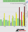
Based on the averages of all earthquakes during the last 24 hours we had a MODERATE seismic activity level. Global seismic activity level chart

~4 quakes above magnitude 5
~46 quakes between magnitude 4 and 5
~88 quakes between magnitude 3 and 4
~251 quakes between magnitude 2 and 3
~663 quakes below magnitude 2 that people normally don't feel.
~1052 quakes past 24 h. (1000 earthquakes in the 24 hours prior to this report) Estimated combined seismic energy released: 4.6 x 10¹³ joules (12.6 gigawatt hours, equivalent to 10877 tons of TNT or 0.7 atomic bombs!)
Volcanodiscovery earthquake report 24h

▪︎Strongest earthquake M5.7 - 138 km N of Lae, Papua New Guinea
2022-09-21 09:30:48 (UTC)
5.470°S 147.026°E. 210.0 km depth
USGS earthquake alert

▪︎M 5.0 - 198 km WSW of Tual, Indonesia
2022-09-21 11:57:51 (UTC)
6.056°S 131.008°E. 60.1 km depth
USGS earthquake alert

▪︎M 5.1 - Turkey-Iran border region
2022-09-21 17:57:59 (UTC)
38.506°N 44.979°E 45.5 km depth
USGS earthquake alert

▪︎M 5.0 - 68 km SSE of Hasaki, Japan
2022-09-21 22:24:41 (UTC)
35.210°N 141.243°E. 17.4 km depth
USGS earthquake alert
 

Attachments

  • chrome_screenshot_1663802247956.png
    chrome_screenshot_1663802247956.png
    366.5 KB · Views: 2
Wow there has just been a strong earthquake, it is 01:20 local time (06:20 UTC).

M 7.0 - 39 km SSW of Aguililla, Mexico
2022-09-22 06:16:11 (UTC)18.400°N 102.900°W61.0 km depth
USGS earthquake alert

SSN adjusts magnitude from M7.0 to M6.9 with epicenter 84 km south of Coalcomán, Michoacán. It was felt in Michoacán, Colima, Jalisco, Guerrero and Mexico City.

It is the largest aftershock of the 7.7 earthquake of September 19; these aftershocks will continue for weeks and even months but will eventually become less frequent.

It happened at 01:16 a.m. and the earthquake lights could be seen again in the night sky.

Damage was reported in Michoacan, epicenter of this earthquake.
 
WORLDWIDE EARTHQUAKE REPORT SEPTEMBER 22

Based on the averages of all earthquakes during the last 24 hours we had a HIGH seismic activity level. Global seismic activity level chart

~1 quake above magnitude 6
~2 quakes between magnitude 5 and 6
~46 quakes between magnitude 4 and 5
~100 quakes between magnitude 3 and 4
~221 quakes between magnitude 2 and 3
~651 quakes below magnitude 2 that people normally don't feel.
~1021 quakes past 24 h. (1052 earthquakes in the 24 hours prior to this report) Estimated combined seismic energy released: 1.5 x 10¹⁵ joules (406 gigawatt hours, equivalent to 3.5 x 10⁵ tons of TNT or 21.8 atomic bombs!)
Volcanodiscovery earthquake report 24h

▪︎Major magnitude 6.9 earthquake - North Pacific Ocean, 149 km southeast of Colima, Mexico, on Thursday, Sep 22, 2022 at 1:16 am (06:16 UTC) - 17 hours ago. Estimated energy: 1.4 x 10¹⁵ joules (392 gigawatt hours, equivalent to 3.4 x 10⁵ tons of TNT or 21.1 atomic bombs)

▪︎M 5.2 - 59 km N of Picton, New Zealand
2022-09-22 09:07:04 (UTC)
40.760°S 174.098°E. 62.9 km depth
USGS earthquake alert

▪︎M 5.2 - 113 km NNE of Hihifo, Tonga
2022-09-22 16:18:52 (UTC)
14.956°S 173.550°W. 20.5 km depth
USGS earthquake alert

Two moderate earthquakes hit Italy

▪︎M 4.4 - 1 km N of Bogliasco, Italy
2022-09-22 13:40:00 (UTC)
44.398°N 9.068°E. 10.0 km depth
USGS earthquake alert

▪︎M 4.6 - 3 km WSW of Abetone, Italy
2022-09-22 15:47:57 (UTC)
44.135°N 10.624°E. 18.7 km depth
USGS earthquake alert

▪︎M 4.6 - 144 km S of Burica, Panama
2022-09-22 19:50:34 (UTC)
6.740°N 82.698°W. 10.0 km depth
USGS earthquake alert
 

Attachments

  • chrome_screenshot_1663887592915.png
    chrome_screenshot_1663887592915.png
    336.1 KB · Views: 1
M 6.2 - 40 km SSW of Meulaboh, Indonesia
2022-09-23 20:52:59 (UTC)
3.810°N 95.987°E 48.6 km depth
USGS earthquake alert
Estimated energy: 8.9 x 10¹³ joules (24.8 gigawatt hours, equivalent to 21301 tons of TNT or 1.3 atomic bombs

Data for the same earthquake reported by different agencies​

Info: The more agencies report about the same quake and post similar data, the more confidence you can have in the data. It takes normally up to a few hours until earthquake parameters are calculated with near-optimum precision.
Mag.DepthLocationSource
6.171 kmNorthern Sumatra, IndonesiaGFZ
6.040 kmNORTHERN SUMATRA, INDONESIAEMSC
6.168 kmNorthern Sumatra, IndonesiaRaspberryShake

Very atypical earthquake in Durango Mexico

Earthquake Magnitude 4.1 Loc 19 km southeast of PAPASQUIARO, DGO 23/09/22 15:18:23 Lat 25.00 Lon -105.24 Depth 11km

 
Strong earthquake in Chile

M 6.1 - 156 km WNW of Ancud, Chile
2022-09-23 22:53:26 (UTC)
41.380°S 75.582°W
10.0 km depth
USGS earthquake alert
Estimated energy4.5 x 1013 joules (12.4 gigawatt hours, equivalent to 10676 tons of TNT or 0.7 atomic bombs.

Data for the same earthquake reported by different agencies​

Info: The more agencies report about the same quake and post similar data, the more confidence you can have in the data. It takes normally up to a few hours until earthquake parameters are calculated with near-optimum precision.
Mag.DepthLocationSource
5.910 kmOff Coast of Southern ChileGFZ
6.210 kmOFF COAST OF LOS LAGOS, CHILEEMSC
5.910 kmOff Coast of Southern ChileRaspberryShake
 
WORLDWIDE EARTHQUAKE REPORT SEPTEMBER 23

For the second consecutive day, based on the averages of all earthquakes during the last 24 hours we had a HIGH seismic activity level. Global seismic activity level chart
chrome_screenshot_1663975197182.png

~2 quakes above magnitude 6 (Sumatra and Chile)
~5 quakes between magnitude 5 and 6
~41 quakes between magnitude 4 and 5
~81 quakes between magnitude 3 and 4
~224 quakes between magnitude 2 and 3
~631 quakes below magnitude 2 that people normally don't feel.
~984 quakes past 24 h. (1021 earthquakes in the 24 hours prior to this report) Estimated combined seismic energy released: 3.8 x 10¹⁴ joules (106 gigawatt hours, equivalent to 91265 tons of TNT or 5.7 atomic bombs)
Volcanodiscovery earthquake report 24h

▪︎M 5.4 - 98 km WNW of Kandrian, Papua New Guinea
2022-09-23 12:34:26 (UTC)
5.996°S 148.687°E. 69.0 km depth
USGS earthquake alert

▪︎M 5.2 - Banda Sea
2022-09-23 20:51:25 (UTC)
5.133°S 125.599°E 10.3 km depth
USGS earthquake alert

▪︎Mainshock and aftershocks Båth's law

The empirical Båth's law states that the average difference in magnitude between a mainshock and its largest aftershock is 1.2, regardless of the mainshock magnitude. Example with latest earthquake in México

Mainshock: M7.6 sep 19/22
Largest aftershock: M6.9 sep 22/22
Difference: 0.7

▪︎ Energy migration

It is expected that the energy from the M7.6 earthquake will migrate to South America. And as we can see Chile has registered a M6.1 earthquake.

250px-Placas_Sudamericanas.png

The eastern edge of the plate lies within a subduction zone beneath the South American plate, which has given rise to the Andes mountain range and the Peruvian-Chilean rift. The southern boundary of the Nazca plate with respect to the Antarctic plate is formed by the Chile ridge, and the western boundary with the Pacific plate by the Eastern Pacific ridge. In the north, the boundary of the Nazca plate with the Cocos plate is largely formed by the Galapagos ridge. The boundaries with these three oceanic plates are divergent, although transform paths are also abundant.
Nazca plate

Other earthquakes in South America past 24h (Nazca Plate)

M 4.6 - 116 km WSW of Santiago de Cao, Peru
2022-09-23 17:58:58 (UTC)
8.542°S 80.122°W 32.2 km depth
USGS earthquake alert

▪︎M 4.5 - 92 km SE of San Pedro de Atacama, Chile
2022-09-23 07:49:15 (UTC)
23.439°S 67.502°W. 144.4 km depth
USGS earthquake alert

▪︎M 4.5 - 122 km SW of Pacocha, Peru
2022-09-23 01:39:25 (UTC)
18.522°S 72.058°W. 24.6 km depth
USGS earthquake alert

▪︎M 4.5 - Tarapaca-Antofagasta border region, Chile
2022-09-23 00:28:37 (UTC)
21.969°S 69.001°W. 141.6 km depth
USGS earthquake alert
 
M 4.8 - 44km W of Petrolia, California
2022-09-24 19:27:37 (UTC)
40.320°N 124.808°W. 2.4 km depth

Estimated energy1 x 1012 joules (278 megawatt hours, equivalent to 239 tons of TNT)

Data for the same earthquake reported by different agencies​

Info: The more agencies report about the same quake and post similar data, the more confidence you can have in the data. It takes normally up to a few hours until earthquake parameters are calculated with near-optimum precision.
Mag.DepthLocationSource
4.82.4 km44km W of Petrolia, CAUSGS
4.836 kmOFFSHORE NORTHERN CALIFORNIAEMSC
4.82.4 km44km W of Petrolia, CARaspberryShake
4.910 kmNear Coast Of Northern Calif.IRIS
4.710 kmNear Coast of Northern CaliforniaGFZ

 
WORLDWIDE EARTHQUAKE REPORT SEPTEMBER 24

Based on the averages of all earthquakes during the last 24 hours we had a LOW seismic activity level. Global seismic activity level chart

~4 quakes above magnitude 5
~39 quakes between magnitude 4 and 5
~87 quakes between magnitude 3 and 4
~186 quakes between magnitude 2 and 3
~482 quakes below magnitude 2 that people normally don't feel.
~798 quakes past 24 h. (984 earthquakes in the 24 hours prior to this report) Estimated combined seismic energy released: 2.2 x 10¹³ joules (5.99 gigawatt hours, equivalent to 5152 tons of TNT or 0.3 atomic bombs!)
Volcanodiscovery earthquake report 24h

▪︎Strongest earthquake M5.1 South Pacific Ocean.
2022-09-24 01:14:23 (UTC)
34.43256°S 178.73599°W. 33 km depth
Volcanodiscovery

▪︎M 5.0 - Mauritius - Reunion region
2022-09-24 17:00:24 (UTC)
20.054°S 66.458°E. 10.0 km depth
USGS earthquake alert

▪︎M 5.0 - 11 km W of Port-Olry, Vanuatu
2022-09-24 19:38:53 (UTC)
15.042°S 166.961°E. 38.0 km depth
USGS earthquake alert

▪︎M 5.0 - South Sandwich Islands region
2022-09-24 21:45:17 (UTC)
59.049°S 25.624°W. 42.6 km depth
USGS earthquake alert

▪︎M 4.6 - 14 km SSW of Caxitepec, Mexico
2022-09-24 15:27:21 (UTC)
17.180°N 99.036°W. 52.2 km depth
USGS earthquake alert

According to the SSN up to 16:00 hours on 24/September/2022, 2,234 aftershocks of the M 7.7 earthquake that occurred in Michoacán on 19/September/2022 have been recorded, the largest of M 6.9.

▪︎M 4.6 - 38 km SW of Puerto El Triunfo, El Salvador
2022-09-24 06:58:29 (UTC)
13.060°N 88.817°W. 78.3 km depth
USGS earthquake alert

▪︎M 4.3 - 51 km SW of Niquero, Cuba
2022-09-24 20:01:42 (UTC)
19.677°N 77.879°W. 16.3 km depth
USGS earthquake alert
 

Attachments

  • chrome_screenshot_1664062144916.png
    chrome_screenshot_1664062144916.png
    324.7 KB · Views: 1
Maybe the sun played a role in the seismic activity in the last days.
(I added the date for some of the peaks)
Screenshot_2022-09-25_09-49-48.png

Around the 4th the proton flux was normal, but there where geomagnetic storms going on:
Screenshot_2022-09-25_09-58-02.png
Screenshot_2022-09-25_09-58-29.png

From the 9th to the 22th the proton flux was elevated:

Screenshot_2022-09-12_06-14-43.png

Screenshot_2022-09-18_08-21-56.png


Screenshot_2022-09-24_08-28-11.png

Kp-index was relatively low/minor or not long lasting during that period:

Screenshot_2022-09-13_07-25-19.png

Screenshot_2022-09-18_08-21-31.png

Screenshot_2022-09-24_08-27-37.png
 
While I'm at it..

Screenshot_2022-09-25_09-49-48.png

Going backward in time, around August 29th the was some minor geomagnetic activity, but also a higher proton flux:
Screenshot_2022-08-31_06-52-37.png

Screenshot_2022-09-25_10-38-37.png

Screenshot_2022-09-25_10-39-05.png

Around August 23th K-index was low. I don't have screenshots of the proton flux in that time, which could mean there wasn't much going on so I didn't take one, but I'm don't know exactly.

Screenshot_2022-09-25_10-40-40.png

Screenshot_2022-09-25_10-46-31.png

Screenshot_2022-09-25_10-46-48.png

On 14th proton flux was low, k-index was low with some activity the days before:

Screenshot_2022-09-25_10-50-42.png

Screenshot_2022-09-25_10-51-33.png
 
Back
Top Bottom