Earthquakes around the world

▪︎Reykjanes Ridge update

On September 29th earthquake swarm continues in Reykjanes Ridge. According to USGS data 14 earthquakes so far. Four earthquakes with magnitude 5 or higher.

M4.9 at 00:38:28 (UTC)
M4.6 at 02:06:46 (UTC)
M5.1 at 02:24:00 (UTC)
M5.0 at 04:08:23 (UTC)
M4.8 at 04:45:07 (UTC)
M4.6 at 05:38:52 (UTC)
M4.8 at 06:36:03 (UTC)
M4.7 at 06:58:37 (UTC)
M4.7 at 07:50:12 (UTC)
M4.7 at 08:14:52 (UTC)
M5.1 at 09:55:58 (UTC)
M4.7 at 12:16:39 (UTC)
M4.8 at 15:11:02 (UTC)

M5.7 at 15:32:30 (UTC)
53.747°N 35.192°W. 10.0 km depth.
Estimated energy released: 5351 tons of TNT or 0.3 atomic bombs
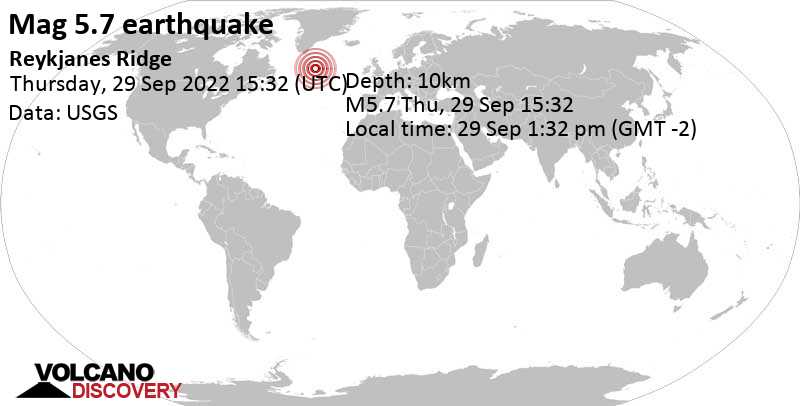
Data for the same earthquake reported by different agencies​

Info: The more agencies report about the same quake and post similar data, the more confidence you can have in the data. It takes normally up to a few hours until earthquake parameters are calculated with near-optimum precision.
Mag.DepthLocationSource
5.710 kmReykjanes RidgeUSGS
5.710 kmREYKJANES RIDGEEMSC
5.710 kmReykjanes RidgeRaspberryShake
5.90.8 kmReykjanes Ridge [Sea]INGV
5.110 kmNear ReykjavíkRENASS
5.810 kmReykjanes RidgeGFZ
5.710 kmReykjanes RidgeIRIS
5.810 kmReykjanes RidgeGeoAu
 
WORLDWIDE EARTHQUAKE REPORT SEPTEMBER 29

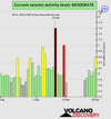
Based on the averages of all earthquakes during the last hours we had a HIGH seismic activity level. Global seismic activity level chart
chrome_screenshot_1664491051554.png

~1 quake above magnitude 6
~8 quakes between magnitude 5 and 6
~53 quakes between magnitude 4 and 5
~91 quakes between magnitude 3 and 4
~225 quakes between magnitude 2 and 3
~506 quakes below magnitude 2 that people normally don't feel.
~884 quakes past 24 h. (899 earthquakes in the 24 hours prior to this report) Estimated combined seismic energy released: 105 tons of TNT or 6.6 atomic bombs.
Volcanodiscovery earthquake report 24h

▪︎Strongest earthquake:

M6.5 - east of the South Sandwich Islands
2022-09-29 03:03:24 (UTC)
60.846°S 20.027°W. 11.0 km depth

▪︎Seismic activity in Reykjanes Ridge has ceased in the last seven hours. Last earthquake M 5.7 at 15:32:30 UTC on September 29

▪︎M 5.5 - 83 km SE of Mawlaik, Myanmar
2022-09-29 22:22:37 (UTC)
23.054°N 94.909°E. 159.3 km depth
USGS earthquake alert

M 5.4 - 89 km WNW of Abepura, Indonesia
2022-09-29 11:34:44 (UTC)
2.434°S 139.848°E 20.6 km depth
USGS earthquake alert

▪︎Earthquake Forecast
As stated in the latest Forecast, planetary geometry remains critical in the final days of September 2022, which means a higher probability of larger seismic activity in the coming days. SSGEOS
 
WORLDWIDE EARTHQUAKE REPORT SEPTEMBER 30

▪︎After the M 5.7 earthquake at 15:32:30 UTC on September 29th, the swarm in Reykjanes Ridge seems to have ceased. Up to 20:00 UTC on September 30, only 5 earthquakes have been recorded, the largest one with a magnitude of 4.8

M 4.6 at 03:22:17 (UTC)
M 4.6 at 11:38:53 (UTC)
M 4.6 at 12:21:08 (UTC)
M 4.8 at 12:50:10 (UTC)
M 4.8 at 19:52:05 (UTC)

Strongest earthquakes today

M 5.9
- 40 km NNE of Sibolga, Indonesia
2022-09-30 19:28:39 (UTC)
2.089°N 98.897°E. 13.2 km depth
USGS earthquake alert

Data for the same earthquake reported by different agencies​

Info: The more agencies report about the same quake and post similar data, the more confidence you can have in the data. It takes normally up to a few hours until earthquake parameters are calculated with near-optimum precision.
Mag.DepthLocationSource
6.010 kmIndonesia: Di Darat 15 Km BaratLaut TapanuliUtaraBMKG
5.840 kmNORTHERN SUMATRA, INDONESIAEMSC
5.913 kmNorthern Sumatra, IndonesiaRaspberryShake
5.410 kmIndonesia: Near MedanRENASS
5.710 kmNorthern Sumatra, IndonesiaGFZ
5.820 kmNorthern Sumatera, Indonesia [Land: Indonesia]INGV
5.944 kmNorthern Sumatra, IndonesiaGeoAu
5.913 km40 Km NNE of Sibolga, IndonesiaUSGS

▪︎M 5.8 - southeast of the Loyalty Islands
2022-09-29 22:59:01 (UTC)22.963°S 172.220°E10.0 km depth
USGS earthquake alert

▪︎M 5.8 - 40 km NNE of Sibolga, Indonesia
2022-09-30 19:28:39 (UTC)
2.089°N 98.897°E. 13.2 km depth
USGS earthquake alert

▪︎M 5.2 - 110 km SSW of Intipucá, El Salvador
2022-09-30 17:32:35 (UTC)
12.240°N 88.332°W. 9.8 km depth
USGS earthquake alert

▪︎M 5.3 - 259 km W of Puerto Chacabuco, Chile
2022-09-30 06:15:46 (UTC)
45.817°S 76.111°W. 10.0 km depth
USGS earthquake alert

▪︎M 5.1 - 111 km NW of Yakutat, Alaska
2022-09-29 23:08:10 (UTC)
60.221°N 141.192°W. 11.2 km depth
USGS earthquake alert

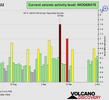
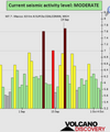
Based on the averages of all earthquakes during the last hours we had a MODERATE seismic activity level. Global seismic activity level chart

~1 quake above magnitude 6
~8 quakes between magnitude 5 and 6
~53 quakes between magnitude 4 and 5
~122 quakes between magnitude 3 and 4
~256 quakes between magnitude 2 and 3
~570 quakes below magnitude 2 that people normally don't feel.
~1010 quakes past 24 h. (899 earthquakes in the 24 hours prior to this report) Estimated combined seismic energy released: 17088 tons of TNT or 1.1 atomic bombs
Volcanodiscovery earthquake report 24h
 

Attachments

  • chrome_screenshot_1664581867541.png
    chrome_screenshot_1664581867541.png
    353.1 KB · Views: 0
▪︎After the M 5.7 earthquake at 15:32:30 UTC on September 29th, the swarm in Reykjanes Ridge seems to have ceased. Up to 20:00 UTC on September 30, only 5 earthquakes have been recorded, the largest one with a magnitude of 4.8

M 4.6 at 03:22:17 (UTC)
M 4.6 at 11:38:53 (UTC)
M 4.6 at 12:21:08 (UTC)
M 4.8 at 12:50:10 (UTC)
M 4.8 at 19:52:05 (UTC)
After a seismic silence of five hours strong earthquake in Reykjanes Ridge.

M 6.0 - Reykjanes Ridge
2022-10-01 01:18:53 (UTC)53.711°N 35.527°W10.0 km depth
USGS earthquake alert
Estimated energy release 15080 tons of TNT or 0.9 atomic bombs

Data for the same earthquake reported by different agencies​

Info: The more agencies report about the same quake and post similar data, the more confidence you can have in the data. It takes normally up to a few hours until earthquake parameters are calculated with near-optimum precision.
Mag.DepthLocationSource
6.010 kmReykjanes RidgeUSGS
5.910 kmREYKJANES RIDGEEMSC
6.010 kmReykjanes RidgeRaspberryShake
5.410 kmNear ReykjavíkRENASS
5.90.8 kmReykjanes Ridge [Sea]INGV
5.810 kmReykjanes RidgeGFZ
6.010 kmReykjanes RidgeGeoAu
Volcanodiscovery
 
WORLDWIDE EARTHQUAKE REPORT OCTOBER 01

Although the number of earthquakes recorded today (752) is less than those recorded yesterday (1010), the estimated energy released and the magnitude of the earthquakes are higher.

After the M6 Reykjanes Ridge earthquake the seismic swarm has ceased. In the last 24h only three M4+ earthquakes have been recorded.

Seismic activity may increase in magnitude according to latest SSGEOS forecast

Strongest earthquakes today

▪︎M 5.7 - 27 km SE of Kushima, Japan
2022-10-01 15:02:32 (UTC)
31.322°N 131.457°E 28.3 km depth
USGS earthquake alert

▪︎M 5.5 - 98 km SSW of Manuel Ávila Camacho (Ponte Duro), Mexico
2022-10-01 16:36:50 (UTC)15.022°N 94.015°W23.7 km depth
USGS earthquake alert

An earthquake of magnitude 5.6 was registered today in Chiapas 130 kilometers southwest of the municipality of Pijijiapan, it was on Saturday morning October 1st at 11:36:51 hours, as reported by the National Symological Service (SSN).

The earthquake in Chiapas was felt in Mexico city, Oaxaca and Veracruz; however, the seismic alert was not activated for any of these states or for Mexico City (CDMX).

The Mexican authority SASMEX mentioned that "it did not merit a seismic alert because the energy estimate in the first seconds did not exceed the pre-established levels. [greater than or equal to magnitude 6]

▪︎M 5.0 - Bonin Islands, Japan region
2022-10-01 12:44:47 (UTC)
28.646°N 140.482°E. 48.5 km depth
USGS earthquake alert

Based on the averages of all earthquakes during the last hours we had a MODERATE seismic activity level. Global seismic activity level chart
chrome_screenshot_1664668287045.png

~1 quake above magnitude 6
~7 quakes between magnitude 5 and 6
~48 quakes between magnitude 4 and 5
~86 quakes between magnitude 3 and 4
~202 quakes between magnitude 2 and 3
~408 quakes below magnitude 2 that people normally don't feel.
~752 quakes past 24 h. (1010 earthquakes in the 24 hours prior to this report) Estimated combined seismic energy released: 35581 tons of TNT or 2.2 atomic bombs.
Volcanodiscovery earthquake report 24h

▪︎Earthquake Forecast
Critical planetary geometry on 30 September and 1 October can trigger larger seismic activity, most likely 1-3 October, potentially reaching 7+ magnitude.

 
Strong earthquake in Greece

M 5.3 - 88 km SSE of Ierápetra, Greece
2022-10-02 04:04:01 (UTC)
34.264°N 26.089°E10.0 km depth
USGS earthquake alert

The quake hit at a shallow depth of 10 km beneath the epicenter near Ierapetra, Lasíthi, Crete, Greece, early morning on Sunday, October 2nd, 2022, at 6:04 am local time.

Based on the preliminary seismic data, the quake should not have caused any significant damage, but was probably felt by many people as light vibration in the area of the epicenter.

Estimated energy release: 477 tons of TNT

Earthquake Forecast
Critical planetary geometry on 30 September and 1 October can trigger larger seismic activity, most likely 1-3 October, potentially reaching 7+ magnitude.

▪︎Earthquake Forecast Update October 02, 04:40 UTC

Atmospheric fluctuation could point to Kermadec (New Zealand), Fiji/Tonga, Loyalty Islands/Vanuatu, Kuril Islands (Japan)/Kamchatka. This is an estimate. Other regions are not excluded. SSGEOS
 
Last week saw 4 M6 and again 1 M7, being a M7.6 in Mexico. One of the M6 was a M6.8 also in Mexico.
In the usual area, there were 4 out of 115 earthquakes worldwide equal to or greater than 4.5 and 1784 out of 2329 quakes of all sizes.
Percentage: 76.6%
Last week saw 2 M6 earthquakes with the strongest being a M6.5 in the South Sandwich Islands.
In the usual area, there were 1 out of 198 earthquakes worldwide equal to or greater than 4.5 and 1538 out of 2225 quakes of all sizes.
Percentage: 69.1%
I think this could be the lowest in the last 3 years of following this segment of America on USGS). It could signal that pressure is not being released but instead is building.
Earthquakes 7 days to October 2nd 2022.gif
 
WORLDWIDE EARTHQUAKE REPORT OCTOBER 02

According to the SSGEOS forecast the planetary configuration may trigger large seismic activity. The highest magnitude earthquake occurred in the Sandwich Islands and reached M5.7

SSN reported an earthquake magnitude 5.6, with epicenter 125 km Northeast of San Jose del Cabo, Baja California Sur at a depth of 10 km. So far, authorities in San Jose del Cabo, have reported no serious damage; however, more details are being awaited.

An earthquake M4.7 hit Turkey, this is the second earthquake in the region in the last 24 h (first one in Greece M5.3)

The number of earthquakes recorded today exceeded the number of earthquakes recorded yesterday, however, the combined estimate of seismic energy released is lower.

Strongest earthquakes today

▪︎M 5.7 - South Sandwich Islands region
2022-10-02 13:05:41 (UTC)
57.768°S 25.410°W. 35.0 km depth
USGS earthquake alert

▪︎M 5.6 - 70 km E of La Rivera, Mexico
2022-10-02 19:00:22 (UTC)
23.514°N 108.898°W. 10.0 km depth
USGS earthquake alert

▪︎M 5.5 - Mid-Indian Ridge
2022-10-02 07:32:25 (UTC)
37.957°S 77.878°E. 10.0 km depth
USGS earthquake alert

▪︎M 5.4 - Mariana Islands region
2022-10-02 18:31:19 (UTC)
16.974°N 147.128°E. 28.5 km depth
USGS earthquake alert

▪︎M 4.7 - 28 km NNE of Ortaca, Turkey
2022-10-02 10:58:04 (UTC)
37.064°N 28.913°E. 10.0 km depth
USGS earthquake alert

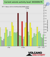
Based on the averages of all earthquakes during the last hours we had a MODERATE seismic activity level. Global seismic activity level chart

Summary:

~7 quakes above magnitude 5
~29 quakes between magnitude 4 and 5
~104 quakes between magnitude 3 and 4
~266 quakes between magnitude 2 and 3
~514 quakes below magnitude 2 that people normally don't feel.
~920 quakes past 24 h. (752 earthquakes in the 24 hours prior to this report) Estimated combined seismic energy released: 19860 tons of TNT or 1.2 atomic bombs
Volcanodiscovery earthquake report 24h
 

Attachments

  • chrome_screenshot_1664753926135.png
    chrome_screenshot_1664753926135.png
    357.3 KB · Views: 0
WORLDWIDE EARTHQUAKE REPORT OCTOBER 03

Due to three earthquakes greater than or equal to magnitude 5, the activity in the past 24h is considered moderate, however, most of the earthquakes of the period were smaller than magnitude 4 and in places where earthquakes are commonly recorded. The Reykjanes Ridge region returned to activity after 24h. Peru was hit with two M4+ earthquakes within 15 minutes of each other.

Strongest earthquakes today:

▪︎M 5.5 - South Sandwich Islands region
2022-10-03 07:00:39 (UTC)
56.400°S 26.035°W. 10.0 km depth
USGS earthquake alert

▪︎M 5.2 - Reykjanes Ridge
2022-10-03 18:08:21 (UTC)
53.714°N 35.512°E. 10.0 km depth
USGS earthquake alert

▪︎M 5.0 - 3 km ENE of Libas, Philippines
2022-10-03 08:07:54 (UTC)
9.901°N 126.010°E. 69.4 km depth
USGS earthquake alert

▪︎M 4.6 - 62 km ESE of Uchiza, Peru
2022-10-03 01:48:49 (UTC)
8.629°S 75.923°W. 10.0 km depth
USGS earthquake alert

▪︎M 4.5 - 44 km ESE of Uchiza, Peru
2022-10-03 02:00:39 (UTC)
8.561°S 76.074°W. 10.0 km depth
USGS earthquake alert

▪︎Summary

Based on the averages of all earthquakes during the last hours we had a MODERATE seismic activity level. Global seismic activity level chart

~3 quakes above magnitude 5
~33 quakes between magnitude 4 and 5
~94 quakes between magnitude 3 and 4
~243 quakes between magnitude 2 and 3
~520 quakes below magnitude 2 that people normally don't feel.
~893 quakes past 24 h. (920 earthquakes in the 24 hours prior to this report) Estimated combined seismic energy release: 6849 tons of TNT or 0.4 atomic bombs
Volcanodiscovery earthquake report 24h
 

Attachments

  • chrome_screenshot_1664839667168.png
    chrome_screenshot_1664839667168.png
    352.1 KB · Views: 0
WORLDWIDE EARTHQUAKE REPORT OCTOBER 04

The past 24 hours have been characterized by low magnitude earthquakes in areas that commonly have moderate to greater seismic activity. At the time of writing this report an M5.7 earthquake occurred in Iran. It may be that this earthquake has a cosmic-human component due to the growing demonstrations against the oppression of women in that country. This was the largest event in the period.

M 5.7 - 11 km ESE of Khowy, Iran
2022-10-05 00:21:29 (UTC)
38.523°N 45.081°E 10.0 km depth
USGS earthquake alert

Based on the preliminary seismic data, the quake was probably felt by many people in the area of the epicenter. It should not have caused significant damage, other than objects falling from shelves, broken windows, etc.
In Marand (pop. 124,200) located 34 km from the epicenter, and Khowy (pop. 175,400) 44 km away, the quake should have been felt as light shaking.

Weak shaking might have been felt in Salmas (pop. 81,600) located 58 km from the epicenter, Qarah Ẕīā'od Dīn (pop. 31,900) 67 km away, Tabriz (pop. 1,424,600) 84 km away, Urmia (pop. 577,300) 94 km away, Nakhichivan (pop. 64,800) 94 km away, and Bonāb (pop. 80,400) 127 km away.

Estimated energy: 5351 tons of TNT or 0.3 atomic bombs

Data for the same earthquake reported by different agencies​

Info: The more agencies report about the same quake and post similar data, the more confidence you can have in the data. It takes normally up to a few hours until earthquake parameters are calculated with near-optimum precision.
Mag.DepthLocationSource
5.710 kmArmenia-Azerbaijan-Iran Border RegionUSGS
5.410 kmNORTHWESTERN IRANEMSC
5.710 kmArmenia-Azerbaijan-Iran Border Reg.RaspberryShake
5.75 kmIRANKOERI-RETMC
5.210 kmIran: Near TabrizRENASS
5.410 kmIran: 7 Km of Khoy, West AzarbaijanIRSC
5.859 kmIran [Land]INGV
5.557 km11 Km ESE of Khowy, IranGFZ
5.710 kmArmenia-Azerbaijan-Iran Bord RegIRIS
Volcanodiscovery

M 5.1 - Pulau Pulau Tanimbar, Indonesia
2022-10-04 22:11:50 (UTC)
7.678°S 130.125°E. 40.2 km depth
USGS earthquake alert

▪︎Summary

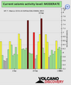
Prior to the earthquakes in Indonesia and Iran, the level of global seismic activity was low: Global seismic activity level chart
chrome_screenshot_1664928297874.png

Now the level has changed to moderate

chrome_screenshot_1664931147649.png

~3 quakes above magnitude 5
~37 quakes between magnitude 4 and 5
~104 quakes between magnitude 3 and 4
~243 quakes between magnitude 2 and 3
~495 quakes below magnitude 2 that people normally don't feel.
~882 quakes past 24 h. (893 earthquakes in the 24 hours prior to this report) Estimated combined seismic energy release: 10154 tons of TNT or 0.6 atomic bombs
Volcanodiscovery earthquake report 24h
 
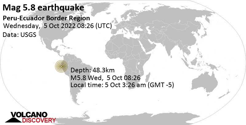
Strong earthquake Peru-Ecuador border region.

An earthquake of magnitude 5.8 occurred early morning on Wednesday, October 5th, 2022, at 3:26 am local time near Sullana, Provincia de Sullana, Piura, Peru,

According to experts, this earthquake was expected to happen as a consequence of the movement of energy towards the Nazca plate after the M7.7 earthquake in Mexico last September 19.

M 5.8 - Peru-Ecuador border region
2022-10-05 08:26:21 (UTC)
4.912°S 80.560°W. 48.3 km depth
USGS earthquake alert

Based on the preliminary seismic data, the quake should have been widely felt by almost everyone in the area of the epicenter. It might have caused light to moderate damage.

Observe the reaction of a dog seconds before the violent earthquake.

Moderate shaking probably occurred in El Salto (pop. 210) located 6 km from the epicenter, Tambo Grande (pop. 30,000) 14 km away, Querecotillo (pop. 25,400) 20 km away, and Sullana (pop. 160,800) 24 km away. In Marcavelica (pop. 25,600) located 26 km from the epicenter, Piura (pop. 325,500) 38 km away, San Martin (pop. 130,000) 40 km away, Chulucanas (pop. 68,800) 41 km away, and Catacaos (pop. 57,300) 48 km away, the quake should have been felt as light shaking.

Estimated energy released: 3.2 x 10¹³ joules (8.78 gigawatt hours, equivalent to 7558 tons of TNT or 0.5 atomic bombs)

Data for the same earthquake reported by different agencies​


Mag.DepthLocationSource
5.848 kmPeru-Ecuador Border RegionUSGS
5.835 kmPERU-ECUADOR BORDER REGIONEMSC
5.848 kmPeru-Ecuador Border RegionRaspberryShake
5.458 kmPeru: Near PiuraRENASS
5.835 kmPeru-Ecuador Border RegionGFZ
6.020 kmPeru [Land]INGV
5.810 kmPeru-Ecuador Border RegionIRIS
6.310 kmPeru-Ecuador Border Region, A 19.39 Km De SullanaIGEPN
5.964 kmPeru-Ecuador Border RegionGeoAu
 

Attachments

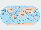
  • Plate-Tectonics-Map-Major-Plates-0-425x319.png
    Plate-Tectonics-Map-Major-Plates-0-425x319.png
    113.4 KB · Views: 1
WORLDWIDE EARTHQUAKE REPORT OCTOBER 05

The results of seismic activity during the month of September were published. As expected, September became the month with the highest seismic activity with 22634 earthquakes and with the highest release of seismic energy equivalent to the explosion of 723.4 atomic bombs, due to the occurrence of three Magnitude 7+ earthquakes

Previously the month with the highest seismic activity was March with 15065 earthquakes, a release of energy equivalent to 215.6 atomic bombs. There was undoubtedly a big difference.

The strongest earthquake occurred in Mexico two weeks ago on monday, Sep 19, 2022 at 1:05 pm (06:05 UTC) with a Mag 7.7 North Pacific Ocean, 99 km southeast of Tecoman, Colima, Mexico.

Other strong earthquakes in September occurred in Papua New Guinea with M7.6 and (sep 11) and Vanuatu with a M7.0 (sep 14)

So far in 2022, there has not been an earthquake of magnitude 8 or greater.

Summary for September:
Magnitude 9+: none
Magnitude 8+: none
Magnitude 7+: 3 earthquakes
Magnitude 6+: 15 earthquakes
Magnitude 5+: 149 earthquakes
Magnitude 4+: 1650 earthquakes
Magnitude 3+: 5859 earthquakes
Magnitude 2+: 14958 earthquakes
Volcanodiscovery earthquake report September 2022

▪︎Total earthquakes September: 22634
Total seismic energy estimate: 4.8 x 10¹⁶ joules (13451 gigawatt hours, equivalent to 1.2 x 10⁷ tons of TNT or 723.4 atomic bombs!)

▪︎Total earthquakes August: 12432
Total seismic energy estimate: 3.3 x 10¹⁵ joules (908 gigawatt hours, equivalent to 7.8 x 10⁵ tons of TNT or 48.8 atomic bombs!)

▪︎Total earthquakes July: 13698
Total seismic energy estimate: 5.3 x 10¹⁵ joules (1480 gigawatt hours, equivalent to 1.3 x 10⁶ tons of TNT or 79.6 atomic bombs)

▪︎Total earthquakes Jun: 12,069
Total seismic energy estimate: 2.5 x 10¹⁵ joules (700 gigawatt hours, equivalent to 6 x 10⁵ tons of TNT or 37.6 atomic bombs!)

▪︎Total earthquakes May: 12456
Total seismic energy estimate: 9.1 x 10¹⁵ joules (2516 gigawatt hours, equivalent to 2.2 x 10⁶ tons of TNT or 135.3 atomic bombs!)

▪︎Total earthquakes April: 12750
Total seismic energy estimate: 3.2 x 10¹⁵ joules (876 gigawatt hours, equivalent to 7.5 x 10⁵ tons of TNT or 47.1 atomic bombs)

▪︎Total earthquakes March: 15065
Total seismic energy estimate: 1.4 x 10¹⁶ joules (4009 gigawatt hours, equivalent to 3.4 x 10⁶ tons of TNT or 215.6 atomic bombs!)

▪︎Total earthquakes February:11198
Total seismic energy estimate: 3.5 x 10¹⁵ joules (979 gigawatt hours, equivalent to 8.4 x 10⁵ tons of TNT or 52.6 atomic bombs!)

▪︎Total earthquakes January: 12435
Total seismic energy estimate: 5.8 x 10¹⁵ joules (1620 gigawatt hours, equivalent to 1.4 x 10⁶ tons of TNT or 87.1 atomic bombs)

Today, October 5th seismic activity has remained at a moderate levels. 3 earthquakes of magnitude 5+ have been registered and the largest one happened in the border between Peru and Ecuador this morning with a magnitude of 5.8. Other earthquakes:

▪︎M 5.3 - South Sandwich Islands region- South Atlantic Ocean
2022-10-05 16:17:18 (UTC)
58.675°S 25.201°W. 31.8 km depth
USGS earthquake alert

▪︎M 5.1 - South Sandwich Islands region-
South Atlantic Ocean
2022-10-05 18:16:49 (UTC)
58.699°S 25.104°W. 10.0 km depth
USGS earthquake alert

Summary

Based on the averages of all earthquakes during the last hours we had a MODERATE seismic activity level. Global seismic activity level chart

~3 quakes above magnitude 5
~29 quakes between magnitude 4 and 5
~96 quakes between magnitude 3 and 4
~245 quakes between magnitude 2 and 3
~564 quakes below magnitude 2 that people normally don't feel.
~937 quakes past 24 h. (882 earthquakes in the 24 hours prior to this report) Estimated combined seismic energy release: 15204 tons of TNT or 1 atomic bomb
Volcanodiscovery earthquake report 24h
 

Attachments

  • chrome_screenshot_1665010229535.png
    chrome_screenshot_1665010229535.png
    335.6 KB · Views: 0
WORLDWIDE EARTHQUAKE REPORT OCTOBER 06

In the last 24 hours the region south of the Sandwich Islands has recorded five M5+ earthquakes. This region is located between two tectonic plates: the South American plate and the Scotia plate. An M5.1 earthquake also occurred very close to that area and on the Mid-Atlantic Ridge.

Japan was hit by two moderate magnitude earthquakes. A very deep 5.3 quake occurred between the Eurasian plate zone and the Philippine plate, while a M4.5 quake occurred at 18:14 UTC on the Pacific plate.

Three earthquakes of magnitude 8+ were recorded in 2021: M8.2 Alaska (July 28)
M8.1 New Zealand (March 04) M8.1 South Sandwich Islands (August 12) 279 days have elapsed in 2022 without an M8.0+ earthquake.

Strongest earthquakes today

M 5.3 - 154 km NW of Nago, Japan
2022-10-06 16:36:09 (UTC)
27.620°N 126.912°E. 177.3 km depth
USGS earthquake alert

M 5.3 - South Sandwich Islands region
2022-10-06 03:50:20 (UTC)
55.968°S 28.119°W. 123.3 km depth
USGS earthquake alert

M 5.1 - South Sandwich Islands region
2022-10-06 02:02:23 (UTC)
58.721°S 25.176°W. 35.0 km depth
USGS earthquake alert

M 5.1 - southern Mid-Atlantic Ridge
2022-10-06 19:27:40 (UTC)
47.218°S 12.081°W. 10.0 km depth
USGS earthquake alert

M 4.9 - South Sandwich Islands region.
(This earthquake was recorded M5.0 by Volcanodiscovery)
2022-10-06 01:05:03 (UTC)
58.687°S 25.215°W. 35.0 km depth
USGS earthquake alert

Summary

Based on the averages of all earthquakes during the last hours we had a MODERATE seismic activity level. Global seismic activity level chart

~5 quakes above magnitude 5
~27 quakes between magnitude 4 and 5
~69 quakes between magnitude 3 and 4
~209 quakes between magnitude 2 and 3
~503 quakes below magnitude 2 that people normally don't feel.
~813 quakes past 24 h. (937 earthquakes in the 24 hours prior to this report) Estimated combined seismic energy release: 7135 tons of TNT or 0.4 atomic bombs
Volcanodiscovery earthquake report 24h
 

Attachments

  • chrome_screenshot_1665095982124.png
    chrome_screenshot_1665095982124.png
    361.5 KB · Views: 0
Felt earthquake in Oregon

M 4.4 - 16 km ESE of Lacomb, Oregon
2022-10-07 12:52:36 (UTC)
44.540°N 122.551°W. 13.2 km depth
USGS earthquake alert

▪︎Earthquake Forecast

Critical planetary geometry on the 7th is followed by a high lunar peak on the 8th, which can result in larger seismic activity, most likely around the 9. Critical planetary and lunar geometry on the 12th may trigger larger seismic activity 12-14 October.

 
WORLDWIDE EARTHQUAKE REPORT OCTOBER 07

Today the level of seismic activity has been low. The largest event was an M5.5 earthquake originally reported as M5.8 near Vailoa, Palauli, Samoa.

M 5.5 - 129 km NE of Hihifo, Tonga
2022-10-07 09:24:49 (UTC)
15.117°S 172.948°W. 10.0 km depth
USGS earthquake alert

Summary

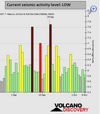
Based on the averages of all earthquakes during the last hours we had a LOW seismic activity level. Global seismic activity level chart

~1 quake above magnitude 5
~31 quakes between magnitude 4 and 5
~86 quakes between magnitude 3 and 4
~206 quakes between magnitude 2 and 3
~494 quakes below magnitude 2 that people normally don't feel.
~818 quakes past 24 h. (813 earthquakes in the 24 hours prior to this report) Estimated combined seismic energy release: 4835 tons of TNT or 0.3 atomic bombs.
Volcanodiscovery earthquake report 24h
 

Attachments

  • chrome_screenshot_1665182799095.png
    chrome_screenshot_1665182799095.png
    324 KB · Views: 0

Trending content

Back
Top Bottom